

Water resources management in modern Egypt
Encyclopedia
Water resources management in modern Egypt is a complex process that involves multiple stakeholders who use water for irrigation, municipal and industrial water supply, hydropower generation and navigation. In addition, the waters of the Nile
support aquatic ecosystems that are threatened by abstraction and pollution. Egypt
also has substantial fossil groundwater resources in the Western Desert.
A key problem of modern water resources management in Egypt is the imbalance between increasing water demand and limited supply. In order to ensure future water availability coordination with the nine upstream Nile riparian countries is essential. The Nile Basin Initiative
provides a forum for such cooperation. In the 1990s the government launched three mega-projects to increase irrigation on "new lands". They are located in the Toshka area (the "New Valley
"), on the fringe of the Western Nile Delta
, and in the Northern Sinai. These projects all require substantial amounts of water that can only be mobilized through better irrigation efficiency and reuse of drainage water and treated wastewater on already irrigated "old lands".
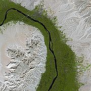
 The history of modern water management in Egypt begins with the construction of the Old Aswan Dam in 1902 and barrages on the Nile in the 19th and early 20th century. The Old Aswan Dam partially stored the waters of the Nile to allow the growing of multiple crops per year in the Nile Delta, while the barrages raised the water level of the Nile so that water could be diverted into large irrigation channels running in parallel to the river. The water regime of the river was changed fundamentally in 1970 when the Aswan High Dam was completed, eliminating the annual Nile flood. The dam brought major benefits such as increased water availability for Egyptian agriculture including during drought years leading to higher income and employment, hydropower production, flood control, improved navigation, and the creation of fisheries in Lake Nasser. But it also had environmental and social impacts including resettlement, loss of fertile silt that now accumulates in the reservoir behind the dam, waterlogging and an increase in soil salinity, and increased coastal erosion.
Unrelated to the construction of the Aswan High Dam, water quality deteriorated through drainage return flows and discharges of untreated municipal and industrial wastewater. Beginning in the 1980s wastewater treatment improved and water quality in the Nile also gradually improved again. Until 1992 the government decided which crops farmers had to grow, which allowed it to deliver specific volumes of water to each canal based on the water needs of the crops. In 1992 a major change occurred when cropping patterns were liberalized and farmers were free to grow what they wanted. At the same time the government began to transfer the responsibility for the management of branch canals to water user associations, a process also called "irrigation transfer". In the mid-1990s the government also initiated three mega-projects to expand irrigation to "new lands" in the desert.
. The High Dam protects Egypt from floods, stores water for year-round irrigation and produces hydro power.
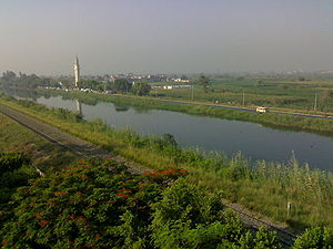 Downstream of the Aswan Dam, there are seven barrages to increase the river's water level so that it can flow into first-level irrigation canals. One of them is the 350 km long Ibrahimiya Canal
completed in 1873, the largest artificial canal in the world. It branches off the left bank of the Nile in Assiut and then runs parallel to the river. Its discharge is increased by the Assiut Barrage
completed in 1903. Other large barrages exist at Esna
and Naga Hammadi on the main Nile, as well as the Delta Barrage
, the zifta
Barrage and the Damietta
Barrage on the Damietta branch and the Edfina barrage on the Rosetta branch of the Nile. Water also flows from the Nile to the Faiyum Oasis
through a canal called Bahr Yussef
that dates back to Pharaonic times. From the oasis it flows to the Birket Qarun (Lake Moesis). The Fresh Water Canal
runs from Cairo to Ismailia
and the Sweet Water Canal
runs in parallel to the Suez Canal
, supplying drinking water to the cities along the Canal. Both canals were completed in 1863. The Mahmoudiya Canal links the Nile to Alexandria. Completed in 1820 it used to have an important role for navigation, but nowadays is used primarily for irrigation and to supply Alexandria with drinking water.
Irrigation canals are classified into principal canals (Rayah), main canals (first level canals), branch canals (second level canals), distribution canals (Mesqas, or third level canals) and irrigation ditches (Merwas). Flow in the principal and main canals is continuous; in the branch and distribution canals it is on a rotation basis. However, the government aims at converting some of the lower-level canals gradually to continuous flow. Farmers pump water from the mesqas to irrigate fields (lift: about 0.5-1.5 m). A Mesqa typically serves an area of 50 to 200 feddan
(20 to 80 hectares). In areas where there is no formal operational structure for proper water distribution, the tail-end users usually are not getting enough water to maintain crops. Water user associations have been formed beginning in the 1990s to better distribute water among farmers on a mesqa and to rationalize pumping, with the aim of reducing water abstraction, pumping costs and to increase yields.
In 1994 Egypt had approximately 30,000 km of public canals (first and second level), 17,000 km of public drains, 80,000 km of private third-level canals (mesqas) and irrigation ditches, 450,000 private water-lifting devices (sakia
s or pumps), 22,000 public water-control structures, and 670 large public pumping stations for irrigation.
Drainage
through sub-surface drains and drainage channels is essential to prevent a deterioration of crop yields from soil salinization and waterlogging
. By 2003 more than 2 million ha have been equipped with a subsurface drainage system
and approximately 7.2 billion m3 of water is drained annually from areas with these systems. The total investment cost in agricultural drainage over 27 years from 1973 to 2002 was about 3.1 billion US$ covering the cost of design, construction, maintenance, research and training. During this period 11 large scale projects were implemented with financial support from World Bank and other donors
or drip irrigation
. Instead they are based on the observation that when farmers lack control of the timing and quantities of water supply, they irrigate too soon and apply too much water.
The feasibility of water savings in Egyptian agriculture was first assessed through pilot projects under the USAID-supported Egypt Water Use and Management Project (EWUP) begun in 1977. The pilots showed that in order to achieve water savings, it was important to allow farmers to participate more in irrigation management through water user associations, to provide continuous flow instead of rotational flow in branch canals, to replace Mesqas, to replace individual by collective pumping, and to create an irrigation advisory service. The 1980 "Strategy for Irrigation Development in Egypt up to the year 2000" already envisaged the improvement of control and distribution of irrigation water as a first phase of the strategy, to be followed by the development of field irrigation systems and direct pricing of irrigation water were to be introduced at later stages. Based on the lessons of EWUP
and the irrigation strategy the government set out the National Irrigation Improvement Program (IIP) in 1984, which was approved by the National Assembly in 1985. Its implementation began, again with support from USAID, in eleven pilot areas, beginning with the Serri Canal with 120,000 feddan (50,400 hectares) in Minya Governorate
. The project replaced the old low-lying Mesqas either with raised Mesqas, from which water would flow to the fields via gravity, or with buried pressurized pipes. By 1998 about 1,100 water user associations had been formed and systems irrigating 129,000 feddan had been modernized. The project reduced water losses, improved water quality at the tail end of mesqas, made more water available to farmers at the tail end of canals, saved land due to the smaller size of the new mesqas, reduced pumping costs by more than 50% and increased yields between 5% and 30%. Building on this success the concept of farmer participation in irrigation management was extended to branch canals with the creation of Branch Canal Water Users Association (BCWUAs) beginning in 1997 in Qemri, Bahr el Dahram and Balaqtar branch canals (Lower Egypt) and El Reity canal (Upper Egypt), as well as in Fayoum.
From 1996 onwards the World Bank
and Germany's development bank KfW
supported the IIP with the ultimate objective to increase agricultural production and income. As part of this project, 2906 water user associations were created irrigating more than 200 thousand feddan (84,000 hectares) in the Western Delta (Mahmoudia) and the Northern Delta (Manaifa and Wasat). However, net revenues increased only by 6-9% due to reduced pumping costs compared to a target of 30%, so that the project was rated as "marginally satisfactory" by the World Bank in 2007.
Beginning in 1996 the government also initiated the creation of drainage user associations (DUAs) to manage drainage canals collectively. However, these associations remained marginal and apparently farmers are not interested in organizing themselves in drainage matters only.
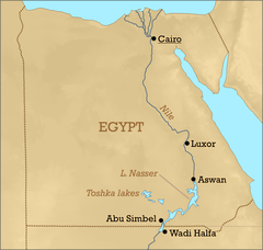
The New Valley Project
(Toshka project) is a system of canals around Sheikh Zayed Canal, fed from Lake Nasser through the Mubarak Pumping Station to irrigate 234,000 hectares in the Sahara. The project was begun in 1997, the pumping station was completed in 2003 and the entire project is scheduled to be completed before 2020.
The Infrastructure Project for Irrigation Improvement in the West Delta Region to improve irrigation on 500 thousand feddan, reclamation of 170 thousand feddan and rehabilitation of infrastructure serving 250 thousand feddan. The latter will be implemented through a public-private partnership
.
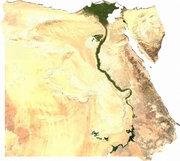
.jpg) Egypt depends for 97% of its water supply on the Nile
Egypt depends for 97% of its water supply on the Nile
. Rainfall is minimal at 18 mm per year, occurring mainly during autumn and winter time. The 1959 Nile waters treaty between Egypt and Sudan allocates 55.5 billion cubic meter of water per year to Egypt, without specifying any allocation for upstream riparians besides Sudan (18.5 billion cubic meter per year). There is no water sharing agreement among all ten riparian countries of the Nile. However, the riparian countries cooperate through the Nile Basin Initiative
.
 Egypt has four main groundwater
aquifer
s: the Nile Aquifer, the Nubian Sandstone Aquifer, the Moghra Aquifer between the West of the Nile Delta and the Qattara Depression
, and coastal aquifers on the North-Western coast. The Nile Aquifer, the Moghra Aquifer and the Coastal Aquifer are renewable. The Nubian Sandstone Aquifer System
which contains 150,000 billion m³ of freshwater, equivalent to almost 3,000 times the annual flow of the Nile, is non-renewable. It is shared with Sudan
, Chad
and Libya
. Egypt’s non-conventional water resources include agricultural drainage, sea water desalination
, brackish water
desalination and municipal wastewater reuse
* ) See also: Irrigation from the Aswan dam for agriculture and the water flow chart
Developments in Sudan, Ethiopia or other riparian countries could reduce water availability to Egypt, for example through increased abstractions for irrigation. However, they could also increase water availability, for example through the draining of swamps such as the Sudd
where large amounts of water currently evaporate.
Furthermore, climate change
is likely to affect water availability to Egypt, although the direction of change is uncertain. According to Nahla Abou El-Fotouh of the National Water Research Centre (NWRC) “Some experts say that there will be water increase with more rainfall from the Ethiopian plateau, and some say there will be a decrease because of water evaporation." According to Mohamed al-Raey, a professor of environmental studies at Alexandria University, some studies foresee a decline of up to 70 percent in Nile water availability, while other studies project an increase in Nile water levels by 25 percent.
Seawater desalination
, which already is used in some resorts on the Red Sea, is also likely to become an increasingly important source for municipal water supply in coastal areas of Egypt. For example, in October 2009 the West Delta Electricity Production Company awarded a contract for a power plant with a 10,000 m3/day seawater desalination plant near Alexandria. Brackish water desalination for irrigation may also become more important.
(IPCC) expects the sea level to rise by up to 59 cm in the worst of all considered scenarios by 2100.
According to studies quoted by the IPCC, climate change could lead to the loss of a "sizable proportion of the northern part of the Nile delta" to "a combination of inundation and erosion". A 0.5-m rise in sea level would lead to estimated losses of land, installations, and tourism of more than US$32.5 billion in the Governorate of Alexandria alone, cutting off the city of Alexandria from the Delta. Erosion already increased in the Nile Delta since the construction of the Aswan High Dam in the 1970s which trapped much of the Nile sediments. Furthermore, agricultural land losses will occur as a result of soil salinization.
The extent of vulnerability of the Nile delta to increases in sea level varies. One study estimates that 30% of the Delta and Alexandria coast is vulnerable, 55% is "invulnerable" and 15% was artificially protected in 2003. High-risk areas in and near the Delta include parts of Alexandria, Behaira, Damietta and Port Said governorates. According to Omran Frihy, a retired coastal researcher, authorities are spending US$300 million to build concrete sea walls to protect the beaches of Alexandria. Sand is being dumped in some areas to replenish dwindling beaches.
According to a report in The Guardian
senior Egyptian environmental officials do not believe climate change is real or are convinced the problem is so great that human intervention is useless.
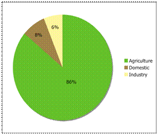 The main water-using sector in Egypt is agriculture, followed by municipal and industrial uses. Total water withdrawal in 2000 was estimated at 68.3 km3.
Navigation. The Nile is also important for navigation, especially for tourism, which makes it necessary to maintain a minimum flow of the Nile year-round.
Ecology. Last but not least the Nile River also has ecological functions that require minimum flows to be maintained, especially for the brackish lakes in the Delta (see below under biodiversity).
Discharge to the sea. Drainage water that is too saline to be used for agriculture is discharged from drainage canals in the Delta to the sea and the northern lakes via drainage pump stations. The total amount of drainage water that was pumped to the sea in 1995/96 has been estimated at 12.4 BCM. This includes about 2.0 BCM/year of seawater that seeps into the drains in the Delta.
has good water quality with only small organic substance
concentrations, which makes its water a reference point for water quality along the river and its branches. According to reports by the Egyptian Environmental Affairs Agency, in 2007 average organic loads in 11 governorates along the Nile remained below the allowed limit of 6 mg/liter of biological oxygen demand (BOD). This is due to the high self-assimilation capacity of the Nile. However, in the same year chemical oxygen demand
was above the allowed limit of 10 mg/liter in 7 of 11 governorates. The report does not include data for some governorates on the Nile such as Monufia and Sharqia. The average level of dissolved oxygen was slightly higher than the allowed minimum of 5 mg/liter in all governorates. The report by the Environmental Authority only shows averages and does not indicate the frequency of standards violations.
A detailed study undertaken in 2002 by a research team working for the Ministry of Water and Irrigation and USAID confirms that the water quality of the Nile River was good despite high organic loads discharged from some of the drains and industrial activities. Water contamination is worst in drainage canals (drains), particularly in all drains in the Delta and some drains in Upper Egypt. The study ranks water pollutants according to their severity to public health and the environment: Pathogenic microorganisms are ranked first, followed by organic compounds. Pesticides and heavy metals are ranked third, while noting that very little information is available to quantify the magnitude of the problem.
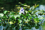 Nitrogen fertilizers whose consumption has doubled between 1980 and 1993 present another source of pollution. Water hyacinth
flourishing at the downstream of water ways due to increased nutrients lead to clogging of canals and is combated with mechanical and biological technologies.
Salinity
is another important water quality issue. Drainage return flows to the Nile result into an increase in salinity of the water from 250 ppm (mg/l) at Aswan to 2,700 ppm at the Delta barrages. However, more salts are being discharged into the Mediterranean Sea
than are entering at Aswan (see Irrigation for agriculture in Egypt) so that in the long run the salinity of the water at the Delta barrages is expected to decrease.
 The Northern Lakes of Egypt are important to preserve biodiversity. From West to East the lakes in the Nile Delta
are Lake Mariout
South of Alexandria, Lake Edku East of Alexandria, Lake Burullus
East of Rosetta and Lake Manzala
between Damietta and Port Said. Another important Northern Lake is Lake Bardawil
in Northern Sinai that is not fed by the Nile. Several hundred thousand water birds winter in these lakes, including the world’s largest concentrations of little gull
s and whiskered tern
s. Other birds making their homes in the delta include grey heron
s, Kentish Plover
s, shovelers
and cormorant
s. Also found are egret
s and ibis
es. Lake Bardawil
and Lake Burullus
are protected wetlands of international importance under the Ramsar Convention
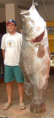
. Despite of the flourishing fish production in Egypt, only 17 species remain as of 1995 out of 47 species in 1948. The Nile Perch
is one of the more prominent fish species in the Egyptian Nile. It is found in Lake Nasser
and in Lake Mariout
in the Nile Delta. Other fish found in the delta include the Striped mullet and soles
. Other animals found in the delta include frog
s, turtle
s, tortoise
s, mongoose
s, and the Nile monitor
.
Lake Manzala
, which used to be a significant source of inexpensive fish for human consumption in Egypt, has been affected by pollution and reduced water inflow. In 1985 the lakes fishery was an open area of 89,000 ha
and employed roughly 17,000 workers. The government drained substantial portions of the lake in an effort to convert its rich Nile deposits to farmland. The project was unprofitable: crops did not grow well in the salty soil and the value of resulting produce was less than the market value of the fish that the reclaimed land had formerly yielded. By 2001, Lake Manzala had lost approximately 80 percent of its former area through the effects of drainage efforts.
that is believed to be from high levels of heavy metals and organchlorine pesticides found in the soil and water. Exposure to cadmium
may be from heavy metals and pesticides found in the water. The water exceeds the European Community Standards of fecal contamination and there is a high salinization and saline intrusion in the delta. Schistosomiasis
has been found in irrigation canals along with benthic cyanobacteria forming mats. Microbiological contamination of water includes fecal coliform bacteria pathogens include hookworm
s and other intestinal helminth eggs.
Among the laws and decrees for environmental protection are:
The important task of water quality monitoring is shared among MWRI, MoHP and MSEA. Each of the three Ministries has its own monitoring sites along the Nile and canals. Groundwater quality is monitored exclusively by MWRI. In addition, three institutes within the National Water Research Center monitor water quality. According to a UN report "Despite the multiplicity of (water quality monitoring) programmes, they have sometimes lacked accurate information and have not been linked up". To improve the quality of monitoring and reporting, Egypt has received support from the Canadian Association for Environmental Analytical Laboratories. Furthermore, a water quality unit has been established, which gathers water quality data from various sections of MWRI and other ministries and collects them in a database with "more than 40 indicators and covering more than 435 sites".
To ensure co-ordination among Ministries involved in water resources there are several committees, including the Supreme Committee of the Nile, headed by the minister of Water and Irrigation,the Committee for Land Reclamation and the Inter-Ministerial Committee on Water Planning. The latter was established in 1977 as a part of the Master Water Plan project.
The following authorities operate under MWRI:
. Rather than being an actual plan, the document aimed at introducing planning tools such as data bases and flow models that would allow better planning. In subsequent years a number of events increased water scarcity. These include a drought in 1979-88; cessation in 1983 of construction works on the Jonglei Canal
in Sudan; and a revitalization of a land reclamation program, requiring one billion m3 of additional water each year. These events helped trigger a greater emphasis on integrated long-term water planning. In 1990 the government adopted its first national water plan covering the period until 2000. Under the plan the government stopped releases of water from Lake Nasser that was only destined for power generation. It also decided to replace old barrages with new ones and it launched the National Irrigation Improvement Program. Furthermore, it aimed to increase the re-use of drainage water and the use of groundwater. On the demand side, water release to the sea at times of low water demand in winter for the sole purpose of maintaining navigation and to regulate sea water intrusion in the Delta was to be reduced. During the period of the plan land reclamation was to continue at a rate of 60,000 hectares per year. The Plan assumed that the Jonglei Canal would be built by 2000.
Some elements of the plan were implemented. Others – such as the Jonglei Canal – did not materialize or were delayed, such as the Irrigation Improvement Program.
Beginning in 1998 the Dutch government provided technical assistance to prepare a second national water plan. The National Water Resources Plan (NWRP) was completed in 2003 with a time horizon until 2017. The plan, which is not publicly available, is based on four principles: to develop additional resources, make better use of existing resources, protect public health and the environment, and improve institutional arrangements. According to the FAO
the plan includes both "vertical expansion" through more efficient water use and increased agricultural productivity and "horizontal expansion" by increasing the existing agricultural area of 7.8 million feddan (about 3.12 million ha) by an additional 1.4 million feddan (about 560 000 ha). In June 2005 the Ministry presented an Integrated Water Resources Management Plan, which was prepared with technical assistance from the World Bank, as a "transitional strategy including further reform interventions" building on the NWRP. The Plan, which reads more like a World Bank report than a report by the Egyptian government, includes 39 actions in the fields of institutional reform and strengthening, policies and legislation, physical interventions, capacity building, technological and information systems, water quality, economic and financial framework, research, raising awareness, monitoring and evaluation and transboundary cooperation. The physical interventions mentioned include irrigation improvement and rural sanitation without mentioning the government's mega-projects that are at the heart of Egypt's actual water policy.
Concerning investment financing, the Soviet Union financed the Aswan High Dam during the 1960s. After Egypt opened itself to the West in the 1970s, the United States, various European countries and the World Bank provided major investment financing for water supply and sanitation and for irrigation and drainage. The Gulf countries partially financed mega-projects to develop new lands for irrigation in the New Valley (supported by the United Arab Emirates) and in Northern Sinai (supported by Kuwait an Saudi Arabia). Concerning technical assistance, the Netherlands, the World Bank and UNDP played important roles in supporting successive national water master plans since the 1980s. UNDP and the National Water Research Center have developed a computer-supported Decision Support System
for Water Resources, which can produce various climate change scenarios for the Nile basin and therefore help to improve water resource planning and management.
Nile
The Nile is a major north-flowing river in North Africa, generally regarded as the longest river in the world. It is long. It runs through the ten countries of Sudan, South Sudan, Burundi, Rwanda, Democratic Republic of the Congo, Tanzania, Kenya, Ethiopia, Uganda and Egypt.The Nile has two major...
support aquatic ecosystems that are threatened by abstraction and pollution. Egypt
Egypt
Egypt , officially the Arab Republic of Egypt, Arabic: , is a country mainly in North Africa, with the Sinai Peninsula forming a land bridge in Southwest Asia. Egypt is thus a transcontinental country, and a major power in Africa, the Mediterranean Basin, the Middle East and the Muslim world...
also has substantial fossil groundwater resources in the Western Desert.
A key problem of modern water resources management in Egypt is the imbalance between increasing water demand and limited supply. In order to ensure future water availability coordination with the nine upstream Nile riparian countries is essential. The Nile Basin Initiative
Nile Basin Initiative
The Nile Basin Initiative is a partnership among the Nile riparian states that “seeks to develop the river in a cooperative manner, share substantial socioeconomic benefits, and promote regional peace and security”...
provides a forum for such cooperation. In the 1990s the government launched three mega-projects to increase irrigation on "new lands". They are located in the Toshka area (the "New Valley
New Valley
New Valley may refer to:* New Valley LLC, an investment company based in Miami, Florida* New Valley Continuation High School, a high school in California* New Valley Governorate, Egypt-See also:* New Hall Valley* New Hope Valley* New Klang Valley...
"), on the fringe of the Western Nile Delta
Nile Delta
The Nile Delta is the delta formed in Northern Egypt where the Nile River spreads out and drains into the Mediterranean Sea. It is one of the world's largest river deltas—from Alexandria in the west to Port Said in the east, it covers some 240 km of Mediterranean coastline—and is a rich...
, and in the Northern Sinai. These projects all require substantial amounts of water that can only be mobilized through better irrigation efficiency and reuse of drainage water and treated wastewater on already irrigated "old lands".
History
Unrelated to the construction of the Aswan High Dam, water quality deteriorated through drainage return flows and discharges of untreated municipal and industrial wastewater. Beginning in the 1980s wastewater treatment improved and water quality in the Nile also gradually improved again. Until 1992 the government decided which crops farmers had to grow, which allowed it to deliver specific volumes of water to each canal based on the water needs of the crops. In 1992 a major change occurred when cropping patterns were liberalized and farmers were free to grow what they wanted. At the same time the government began to transfer the responsibility for the management of branch canals to water user associations, a process also called "irrigation transfer". In the mid-1990s the government also initiated three mega-projects to expand irrigation to "new lands" in the desert.
Existing infrastructure
Water resources management in Egypt depends on a complex set of infrastructure along the entire length of the river. The key element of this infrastructure is the Aswan High Dam that forms Lake NasserLake Nasser
Lake Nasser is a vast reservoir in southern Egypt, and northern Sudan, and is one of the largest man-made lakes in the world. Strictly, "Lake Nasser" refers only to the much larger portion of the lake that is in Egyptian territory , with the Sudanese preferring to call their smaller body of water...
. The High Dam protects Egypt from floods, stores water for year-round irrigation and produces hydro power.
Ibrahimiya Canal
The Ibrahimiyah Canal is an irrigation canal in Egypt built in 1873. It was the most important public work executed under the then newly established Ministry of Public Works. It was built during the reign of Ismail Pasha when he was Khedive of Egypt...
completed in 1873, the largest artificial canal in the world. It branches off the left bank of the Nile in Assiut and then runs parallel to the river. Its discharge is increased by the Assiut Barrage
Assiut Barrage
The Assiut Barrage is a dam on the Nile in the city of Assiut in Upper Egypt . It was designed by the famous British engineer Sir William Willcocks who also designed and built the Aswan Dam...
completed in 1903. Other large barrages exist at Esna
Esna
Esna , known to the ancient Egyptians as Egyptian: Iunyt or Ta-senet; Greek: or or ; Latin: Lato, is a city in Egypt. It is located on the west bank of the River Nile, some 55 km south of Luxor...
and Naga Hammadi on the main Nile, as well as the Delta Barrage
Delta Barrage
The Delta Barrage is barrage that was completed in 1862. Its purpose was to improve irrigation in the Nile Delta area of Egypt.It was recorded by historians that Muhammad Ali of Egypt's grandson Abbas sacrificed one of the pyramids in order to build the dam which was very poorly financed.When it...
, the zifta
Zifta
Zifta: is an Egyptian town in the Nile delta, belongs to Gharbia governorate. It is across the nile from Mit Ghamr city of Ad Daqahliyah governorate.-History:...
Barrage and the Damietta
Damietta
Damietta , also known as Damiata, or Domyat, is a port and the capital of the Damietta Governorate in Egypt. It is located at the intersection between the Mediterranean Sea and the Nile, about north of Cairo.-History:...
Barrage on the Damietta branch and the Edfina barrage on the Rosetta branch of the Nile. Water also flows from the Nile to the Faiyum Oasis
Faiyum Oasis
The Faiyum Oasis is a depression or basin in the desert immediately to the west of the Nile south of Cairo. The extent of the basin area is estimated at between 490 mi² and 656 mi²...
through a canal called Bahr Yussef
Bahr Yussef
The Bahr Yussef, which roughly translates from Arabic as "the waterway of Joseph", is a canal which connects the Nile River with Fayyum in Egypt. This was originally in prehistoric times a natural offshoot of the Nile which created a lake to the west during high floods. Beginning with the 12th...
that dates back to Pharaonic times. From the oasis it flows to the Birket Qarun (Lake Moesis). The Fresh Water Canal
Fresh Water Canal
The Fresh Water Canal is a modern canal of Egypt, also called the Ismaïlia Canal, that runs through the now dry distributary of the Wadi Tumilat and from Cairo to Suez...
runs from Cairo to Ismailia
Ismaïlia
-Notable natives:*Osman Ahmed Osman, a famous and influential Egyptian engineer, contractor, entrepreneur, and politician, was born in this town on 6 April 1917....
and the Sweet Water Canal
Sweet Water Canal
The Sweet Water Canal is a modern canal of Egypt, running along the northern periphery of the now dry distributary of the Wadi Tumilat and extending from Port Said in the north all the way to Suez in the south....
runs in parallel to the Suez Canal
Suez Canal
The Suez Canal , also known by the nickname "The Highway to India", is an artificial sea-level waterway in Egypt, connecting the Mediterranean Sea and the Red Sea. Opened in November 1869 after 10 years of construction work, it allows water transportation between Europe and Asia without navigation...
, supplying drinking water to the cities along the Canal. Both canals were completed in 1863. The Mahmoudiya Canal links the Nile to Alexandria. Completed in 1820 it used to have an important role for navigation, but nowadays is used primarily for irrigation and to supply Alexandria with drinking water.
Irrigation canals are classified into principal canals (Rayah), main canals (first level canals), branch canals (second level canals), distribution canals (Mesqas, or third level canals) and irrigation ditches (Merwas). Flow in the principal and main canals is continuous; in the branch and distribution canals it is on a rotation basis. However, the government aims at converting some of the lower-level canals gradually to continuous flow. Farmers pump water from the mesqas to irrigate fields (lift: about 0.5-1.5 m). A Mesqa typically serves an area of 50 to 200 feddan
Feddan
A feddan is a unit of area. It is used in Egypt, Sudan, and Syria. The feddan is not an SI unit and in Arabic, the word means 'a yoke of oxen': implying the area of ground that could be tilled by them in a certain time. In Egypt the feddan is the only non-metric unit which remained in use...
(20 to 80 hectares). In areas where there is no formal operational structure for proper water distribution, the tail-end users usually are not getting enough water to maintain crops. Water user associations have been formed beginning in the 1990s to better distribute water among farmers on a mesqa and to rationalize pumping, with the aim of reducing water abstraction, pumping costs and to increase yields.
In 1994 Egypt had approximately 30,000 km of public canals (first and second level), 17,000 km of public drains, 80,000 km of private third-level canals (mesqas) and irrigation ditches, 450,000 private water-lifting devices (sakia
Sakia
A sakia , tympanum or tablia is a water wheel, somewhat similar to a noria, and used primarily in Egypt. It is a large hollow wheel, normally made of galvanized sheet steel, with scoops or buckets at the periphery...
s or pumps), 22,000 public water-control structures, and 670 large public pumping stations for irrigation.
Drainage
Drainage
Drainage is the natural or artificial removal of surface and sub-surface water from an area. Many agricultural soils need drainage to improve production or to manage water supplies.-Early history:...
through sub-surface drains and drainage channels is essential to prevent a deterioration of crop yields from soil salinization and waterlogging
Waterlogging
Waterlogging or water logging may refer to:* Waterlogging , saturation of the soil by groundwater sufficient to prevent or hinder agriculture...
. By 2003 more than 2 million ha have been equipped with a subsurface drainage system
Drainage system (Agriculture)
An agricultural drainage system is a system by which the water level on or in the soil is controlled to enhance agricultural crop production.-Classification:Figure 1 classifies the various types of drainage systems...
and approximately 7.2 billion m3 of water is drained annually from areas with these systems. The total investment cost in agricultural drainage over 27 years from 1973 to 2002 was about 3.1 billion US$ covering the cost of design, construction, maintenance, research and training. During this period 11 large scale projects were implemented with financial support from World Bank and other donors
Irrigation Improvement Program
Water savings in agriculture are an important objective of Egypt’s water strategy to serve a growing population with limited resources. However, the magnitude of potential water savings in agriculture and how best to achieve such savings have been a subject of some debate. While field-level irrigation efficiencies may be low due to the predominance of flood irrigation, the overall system efficiency is quite high due to return flows. Water savings strategies in Egypt therefore do not focus much on water-saving irrigation technologies such as sprinklerIrrigation sprinkler
Irrigation sprinklers are sprinklers used on farms, golf courses, and yards, to provide water to vegetation and plants in the event of drought. They may also be used for recreation, as a cooling system, or to keep down the amount of airborne dust....
or drip irrigation
Drip irrigation
Drip irrigation, also known as trickle irrigation or microirrigation or localized irrigation , is an irrigation method which saves water and fertilizer by allowing water to drip slowly to the roots of plants, either onto the soil surface or directly onto the root zone, through a network of valves,...
. Instead they are based on the observation that when farmers lack control of the timing and quantities of water supply, they irrigate too soon and apply too much water.
The feasibility of water savings in Egyptian agriculture was first assessed through pilot projects under the USAID-supported Egypt Water Use and Management Project (EWUP) begun in 1977. The pilots showed that in order to achieve water savings, it was important to allow farmers to participate more in irrigation management through water user associations, to provide continuous flow instead of rotational flow in branch canals, to replace Mesqas, to replace individual by collective pumping, and to create an irrigation advisory service. The 1980 "Strategy for Irrigation Development in Egypt up to the year 2000" already envisaged the improvement of control and distribution of irrigation water as a first phase of the strategy, to be followed by the development of field irrigation systems and direct pricing of irrigation water were to be introduced at later stages. Based on the lessons of EWUP
and the irrigation strategy the government set out the National Irrigation Improvement Program (IIP) in 1984, which was approved by the National Assembly in 1985. Its implementation began, again with support from USAID, in eleven pilot areas, beginning with the Serri Canal with 120,000 feddan (50,400 hectares) in Minya Governorate
Minya Governorate
Minya Governorate is one of the governorates of Upper Egypt. The name originates from the chief city of the governorate, originally known in Sahidic Coptic as Tmoone and in Bohairic as Thmonē , meaning “the residence”, in reference to a monastery formerly in the area...
. The project replaced the old low-lying Mesqas either with raised Mesqas, from which water would flow to the fields via gravity, or with buried pressurized pipes. By 1998 about 1,100 water user associations had been formed and systems irrigating 129,000 feddan had been modernized. The project reduced water losses, improved water quality at the tail end of mesqas, made more water available to farmers at the tail end of canals, saved land due to the smaller size of the new mesqas, reduced pumping costs by more than 50% and increased yields between 5% and 30%. Building on this success the concept of farmer participation in irrigation management was extended to branch canals with the creation of Branch Canal Water Users Association (BCWUAs) beginning in 1997 in Qemri, Bahr el Dahram and Balaqtar branch canals (Lower Egypt) and El Reity canal (Upper Egypt), as well as in Fayoum.
From 1996 onwards the World Bank
World Bank
The World Bank is an international financial institution that provides loans to developing countries for capital programmes.The World Bank's official goal is the reduction of poverty...
and Germany's development bank KfW
KFW
KFW may refer to:*Keith Fullerton Whitman , an American musician*KfW or Kreditanstalt für Wiederaufbau, a German public-sector financial institution...
supported the IIP with the ultimate objective to increase agricultural production and income. As part of this project, 2906 water user associations were created irrigating more than 200 thousand feddan (84,000 hectares) in the Western Delta (Mahmoudia) and the Northern Delta (Manaifa and Wasat). However, net revenues increased only by 6-9% due to reduced pumping costs compared to a target of 30%, so that the project was rated as "marginally satisfactory" by the World Bank in 2007.
Beginning in 1996 the government also initiated the creation of drainage user associations (DUAs) to manage drainage canals collectively. However, these associations remained marginal and apparently farmers are not interested in organizing themselves in drainage matters only.
Mega-projects under construction
The North Sinai Development Project includes the Al-Salam Canal in front of Damietta Lock and Dam with the purpose of reclaiming 220 thousand feddans west of the Suez Canal, of which 180 thousand feddan are already irrigated. A siphon was built in 1997 under the Suez Canal to bring water to the Sinai through the Al-Sheikh Gaber Al-Sabah Canal to reclaim 400 thousand feddans east of the Suez Canal.The New Valley Project
New Valley Project
The New Valley Project consists of building a system of canals to carry water from Lake Nasser to irrigate the sandy wastes of the Western Desert of Egypt, which is part of the Sahara Desert. In 1997 the Egyptian government decided to develop a "new" valley where agricultural and industrial...
(Toshka project) is a system of canals around Sheikh Zayed Canal, fed from Lake Nasser through the Mubarak Pumping Station to irrigate 234,000 hectares in the Sahara. The project was begun in 1997, the pumping station was completed in 2003 and the entire project is scheduled to be completed before 2020.
The Infrastructure Project for Irrigation Improvement in the West Delta Region to improve irrigation on 500 thousand feddan, reclamation of 170 thousand feddan and rehabilitation of infrastructure serving 250 thousand feddan. The latter will be implemented through a public-private partnership
Public-private partnership
Public–private partnership describes a government service or private business venture which is funded and operated through a partnership of government and one or more private sector companies...
.
Current resources
Nile
The Nile is a major north-flowing river in North Africa, generally regarded as the longest river in the world. It is long. It runs through the ten countries of Sudan, South Sudan, Burundi, Rwanda, Democratic Republic of the Congo, Tanzania, Kenya, Ethiopia, Uganda and Egypt.The Nile has two major...
. Rainfall is minimal at 18 mm per year, occurring mainly during autumn and winter time. The 1959 Nile waters treaty between Egypt and Sudan allocates 55.5 billion cubic meter of water per year to Egypt, without specifying any allocation for upstream riparians besides Sudan (18.5 billion cubic meter per year). There is no water sharing agreement among all ten riparian countries of the Nile. However, the riparian countries cooperate through the Nile Basin Initiative
Nile Basin Initiative
The Nile Basin Initiative is a partnership among the Nile riparian states that “seeks to develop the river in a cooperative manner, share substantial socioeconomic benefits, and promote regional peace and security”...
.
Groundwater
Groundwater is water located beneath the ground surface in soil pore spaces and in the fractures of rock formations. A unit of rock or an unconsolidated deposit is called an aquifer when it can yield a usable quantity of water. The depth at which soil pore spaces or fractures and voids in rock...
aquifer
Aquifer
An aquifer is a wet underground layer of water-bearing permeable rock or unconsolidated materials from which groundwater can be usefully extracted using a water well. The study of water flow in aquifers and the characterization of aquifers is called hydrogeology...
s: the Nile Aquifer, the Nubian Sandstone Aquifer, the Moghra Aquifer between the West of the Nile Delta and the Qattara Depression
Qattara Depression
The Qattara Depression is a depression in the north west of Egypt in the Matruh Governorate and is part of the Libyan Desert. It lies below sea level and is covered with salt pans, sand dunes and salt marshes. The region extends between latitudes of 28°35' and 30°25' North and longitudes of 26°20'...
, and coastal aquifers on the North-Western coast. The Nile Aquifer, the Moghra Aquifer and the Coastal Aquifer are renewable. The Nubian Sandstone Aquifer System
Nubian Sandstone Aquifer System
The Nubian Sandstone Aquifer System is the world’s largest known fossil water aquifer system. It is located underground in the Eastern end of the Sahara Desert and spans the political boundaries of four countries in north-eastern Africa...
which contains 150,000 billion m³ of freshwater, equivalent to almost 3,000 times the annual flow of the Nile, is non-renewable. It is shared with Sudan
Sudan
Sudan , officially the Republic of the Sudan , is a country in North Africa, sometimes considered part of the Middle East politically. It is bordered by Egypt to the north, the Red Sea to the northeast, Eritrea and Ethiopia to the east, South Sudan to the south, the Central African Republic to the...
, Chad
Chad
Chad , officially known as the Republic of Chad, is a landlocked country in Central Africa. It is bordered by Libya to the north, Sudan to the east, the Central African Republic to the south, Cameroon and Nigeria to the southwest, and Niger to the west...
and Libya
Libya
Libya is an African country in the Maghreb region of North Africa bordered by the Mediterranean Sea to the north, Egypt to the east, Sudan to the southeast, Chad and Niger to the south, and Algeria and Tunisia to the west....
. Egypt’s non-conventional water resources include agricultural drainage, sea water desalination
Desalination
Desalination, desalinization, or desalinisation refers to any of several processes that remove some amount of salt and other minerals from saline water...
, brackish water
Brackish water
Brackish water is water that has more salinity than fresh water, but not as much as seawater. It may result from mixing of seawater with fresh water, as in estuaries, or it may occur in brackish fossil aquifers. The word comes from the Middle Dutch root "brak," meaning "salty"...
desalination and municipal wastewater reuse
| Water Resources and Extraction in Egypt *) | |
|---|---|
| Type of Water Resources |
Quantity in billion m³ per year |
| Nile River | 56.8 |
| Precipitation | 1.8 |
| Fossil Groundwater Extraction | 1 |
| Sea Water Desalination | 0.1 |
| Sum | 59.7 |
| Reuse of Spilled Water Resources *) | |
| Renewable Groundwater Extraction | 2.3 |
| Wastewater Reuse | 2.9 |
| Agricultural Drainage Reuse | 7.5 |
| Sum | 12.7 |
Future resources
It is forecasted that in 2025 the population of Egypt will increase from about 75 million in 2008 to about 95 million, leading to a decrease in per capita water availability from 800 to 600 m³ per year assuming that total water availability remains constant.Developments in Sudan, Ethiopia or other riparian countries could reduce water availability to Egypt, for example through increased abstractions for irrigation. However, they could also increase water availability, for example through the draining of swamps such as the Sudd
Sudd
The Sudd , also known as the Bahr al Jabal, As Sudd or Al Sudd, is a vast swamp in South Sudan, formed by the White Nile. The word “sudd” is derived from the Arabic word “sadd”, meaning “block.” The term has come to refer to any large solid floating vegetation island or mat...
where large amounts of water currently evaporate.
Furthermore, climate change
Climate change
Climate change is a significant and lasting change in the statistical distribution of weather patterns over periods ranging from decades to millions of years. It may be a change in average weather conditions or the distribution of events around that average...
is likely to affect water availability to Egypt, although the direction of change is uncertain. According to Nahla Abou El-Fotouh of the National Water Research Centre (NWRC) “Some experts say that there will be water increase with more rainfall from the Ethiopian plateau, and some say there will be a decrease because of water evaporation." According to Mohamed al-Raey, a professor of environmental studies at Alexandria University, some studies foresee a decline of up to 70 percent in Nile water availability, while other studies project an increase in Nile water levels by 25 percent.
Seawater desalination
Desalination
Desalination, desalinization, or desalinisation refers to any of several processes that remove some amount of salt and other minerals from saline water...
, which already is used in some resorts on the Red Sea, is also likely to become an increasingly important source for municipal water supply in coastal areas of Egypt. For example, in October 2009 the West Delta Electricity Production Company awarded a contract for a power plant with a 10,000 m3/day seawater desalination plant near Alexandria. Brackish water desalination for irrigation may also become more important.
Impact of sea level rise in the Nile Delta
The Intergovernmental Panel on Climate ChangeIntergovernmental Panel on Climate Change
The Intergovernmental Panel on Climate Change is a scientific intergovernmental body which provides comprehensive assessments of current scientific, technical and socio-economic information worldwide about the risk of climate change caused by human activity, its potential environmental and...
(IPCC) expects the sea level to rise by up to 59 cm in the worst of all considered scenarios by 2100.
According to studies quoted by the IPCC, climate change could lead to the loss of a "sizable proportion of the northern part of the Nile delta" to "a combination of inundation and erosion". A 0.5-m rise in sea level would lead to estimated losses of land, installations, and tourism of more than US$32.5 billion in the Governorate of Alexandria alone, cutting off the city of Alexandria from the Delta. Erosion already increased in the Nile Delta since the construction of the Aswan High Dam in the 1970s which trapped much of the Nile sediments. Furthermore, agricultural land losses will occur as a result of soil salinization.
The extent of vulnerability of the Nile delta to increases in sea level varies. One study estimates that 30% of the Delta and Alexandria coast is vulnerable, 55% is "invulnerable" and 15% was artificially protected in 2003. High-risk areas in and near the Delta include parts of Alexandria, Behaira, Damietta and Port Said governorates. According to Omran Frihy, a retired coastal researcher, authorities are spending US$300 million to build concrete sea walls to protect the beaches of Alexandria. Sand is being dumped in some areas to replenish dwindling beaches.
According to a report in The Guardian
The Guardian
The Guardian, formerly known as The Manchester Guardian , is a British national daily newspaper in the Berliner format...
senior Egyptian environmental officials do not believe climate change is real or are convinced the problem is so great that human intervention is useless.
Water use
Agriculture and reuse of drainage water
Data on agricultural water use in Egypt are not precise and often contradictory. The total area equipped for irrigation was 3.4 million hectares in 2002; 85 percent of this area is in the Nile Valley and Delta. Agriculture used about 59 km3 of freshwater in 2000 (86 percent of total use). All drainage water in Upper Egypt, south of Cairo, flows back into the Nile and the irrigation canals; this amount is estimated at 4 km3/yr. Drainage water in the Nile Delta is estimated at 14 km3/yr. As mentioned below about 10 km3/year of drainage water in the Delta that originates from freshwater is being pumped to the sea. Reuse of drainage water occurs in three different ways:- Official reuse through public pumping stations that pump water from drains to irrigation canals. This accounts for about 4.5 BCM/year in the Delta and 0.9 BCM/year in Upper Egypt and Faiyoum.
- Unofficial reuse done by farmers themselves when they are short of canal water. In the Delta alone this has been estimated to be around 2.8 BCM/year.
- Indirect reuse from drains in Upper Egypt that discharge into the Nile, amounting to about 4 BCM/year.
Municipal and industrial use
5.3 km3 of water was used for municipal uses (8 percent) and 4.0 km3 by industry (6 percent). It has been estimated that about 3.5 BCM/year of municipal waste water was being discharged into the Nile and the sea in 2002, out of which only 1.6 BCM/year (about 45%) were treated. Industrial effluents contribute to about 1.3 BCM/yr of waste water being discharged to surface waters, only some of which is being treated.Other uses
Hydropower. An important use of water in Egypt is for the production of hydropower. This use is non-consumptive and is thus available for other uses further downstream. Hydropower plants exist at the Aswan High Dam (2100 MW), the old Aswan Dam (270 MW)and power plants at the Esna (90 MW) and Naga Hammadi weirs (64 MW). Together these plants accounted for 16% of installed electricity generation capacity in 2004. The share of hydropower in power generation declines since the hydropower potential is largely exploited and power demand increases rapidly.Navigation. The Nile is also important for navigation, especially for tourism, which makes it necessary to maintain a minimum flow of the Nile year-round.
Ecology. Last but not least the Nile River also has ecological functions that require minimum flows to be maintained, especially for the brackish lakes in the Delta (see below under biodiversity).
Discharge to the sea. Drainage water that is too saline to be used for agriculture is discharged from drainage canals in the Delta to the sea and the northern lakes via drainage pump stations. The total amount of drainage water that was pumped to the sea in 1995/96 has been estimated at 12.4 BCM. This includes about 2.0 BCM/year of seawater that seeps into the drains in the Delta.
Surface water quality
Water quality in the Nile deteriorates along the course of the river. Lake NasserLake Nasser
Lake Nasser is a vast reservoir in southern Egypt, and northern Sudan, and is one of the largest man-made lakes in the world. Strictly, "Lake Nasser" refers only to the much larger portion of the lake that is in Egyptian territory , with the Sudanese preferring to call their smaller body of water...
has good water quality with only small organic substance
concentrations, which makes its water a reference point for water quality along the river and its branches. According to reports by the Egyptian Environmental Affairs Agency, in 2007 average organic loads in 11 governorates along the Nile remained below the allowed limit of 6 mg/liter of biological oxygen demand (BOD). This is due to the high self-assimilation capacity of the Nile. However, in the same year chemical oxygen demand
Chemical oxygen demand
In environmental chemistry, the chemical oxygen demand test is commonly used to indirectly measure the amount of organic compounds in water. Most applications of COD determine the amount of organic pollutants found in surface water or wastewater, making COD a useful measure of water quality...
was above the allowed limit of 10 mg/liter in 7 of 11 governorates. The report does not include data for some governorates on the Nile such as Monufia and Sharqia. The average level of dissolved oxygen was slightly higher than the allowed minimum of 5 mg/liter in all governorates. The report by the Environmental Authority only shows averages and does not indicate the frequency of standards violations.
A detailed study undertaken in 2002 by a research team working for the Ministry of Water and Irrigation and USAID confirms that the water quality of the Nile River was good despite high organic loads discharged from some of the drains and industrial activities. Water contamination is worst in drainage canals (drains), particularly in all drains in the Delta and some drains in Upper Egypt. The study ranks water pollutants according to their severity to public health and the environment: Pathogenic microorganisms are ranked first, followed by organic compounds. Pesticides and heavy metals are ranked third, while noting that very little information is available to quantify the magnitude of the problem.
Water hyacinth
The seven species of water hyacinth comprise the genus Eichhornia. Water hyacinth are a free-floating perennial aquatic plant native to tropical and sub-tropical South America. With broad, thick, glossy, ovate leaves, water hyacinth may rise above the surface of the water as much as 1 meter in...
flourishing at the downstream of water ways due to increased nutrients lead to clogging of canals and is combated with mechanical and biological technologies.
Salinity
Salinity
Salinity is the saltiness or dissolved salt content of a body of water. It is a general term used to describe the levels of different salts such as sodium chloride, magnesium and calcium sulfates, and bicarbonates...
is another important water quality issue. Drainage return flows to the Nile result into an increase in salinity of the water from 250 ppm (mg/l) at Aswan to 2,700 ppm at the Delta barrages. However, more salts are being discharged into the Mediterranean Sea
Mediterranean Sea
The Mediterranean Sea is a sea connected to the Atlantic Ocean surrounded by the Mediterranean region and almost completely enclosed by land: on the north by Anatolia and Europe, on the south by North Africa, and on the east by the Levant...
than are entering at Aswan (see Irrigation for agriculture in Egypt) so that in the long run the salinity of the water at the Delta barrages is expected to decrease.
Biodiversity
Nile Delta
The Nile Delta is the delta formed in Northern Egypt where the Nile River spreads out and drains into the Mediterranean Sea. It is one of the world's largest river deltas—from Alexandria in the west to Port Said in the east, it covers some 240 km of Mediterranean coastline—and is a rich...
are Lake Mariout
Lake Mariout
Lake Mariout Buhayrat Mariyyut is a brackish lake in northern Egypt. The lake area covered 200 km² at the beginning of the 20th century, but at the beginning of the 21th century it coveres only about 50 km². It is separated from the Mediterranean Sea by the narrow isthmus on which the...
South of Alexandria, Lake Edku East of Alexandria, Lake Burullus
Lake Burullus
Lake Burullus is a brackish water lake in the Nile Delta in Egypt. It is located in Kafr el-Sheikh Governorate east of Rosetta, bordered by the Mediterranean Sea in the north and agricultural land to the south.-Hydrology:...
East of Rosetta and Lake Manzala
Lake Manzala
Lake Manzala is a brackish lake, sometimes called a lagoon, in northeastern Egypt on the Nile Delta near Port Said and a few miles from the ancient ruins at Tanis. It is the largest of the northern deltaic lakes of Egypt. As of 2008 it is 47km long and 30km wide.-Geography:Lake Manzala is long but...
between Damietta and Port Said. Another important Northern Lake is Lake Bardawil
Lake Bardawil
Lake Bardawil is a large, very saline lake in Egypt on the north coast of the Sinai Peninsula. The lagoon is shallow and is separated from the Mediterranean Sea by a narrow sandbar. It has Ramsar Convention protected wetlands.Lake Bardawil is about long, and wide...
in Northern Sinai that is not fed by the Nile. Several hundred thousand water birds winter in these lakes, including the world’s largest concentrations of little gull
Little Gull
The Little Gull, Hydrocoloeus minutus or Larus minutus, is a small gull which breeds in northern Europe and Asia. It also has small colonies in parts of southern Canada. It is migratory, wintering on coasts in western Europe, the Mediterranean and the northeast USA. As is the case with many gulls,...
s and whiskered tern
Whiskered Tern
The Whiskered Tern is a seabird of the tern family Sternidae. This bird has a number of geographical races, differing mainly in size and minor plumage details....
s. Other birds making their homes in the delta include grey heron
Grey Heron
The Grey Heron , is a wading bird of the heron family Ardeidae, native throughout temperate Europe and Asia and also parts of Africa. It is resident in the milder south and west, but many birds retreat in winter from the ice in colder regions...
s, Kentish Plover
Kentish Plover
The Kentish Plover, Charadrius alexandrinus, is a small wader in the plover bird family. Despite its name, this species no longer breeds in Kent, or even Great Britain...
s, shovelers
Northern Shoveler
The Northern Shoveler , Northern Shoveller in British English, sometimes known simply as the Shoveler, is a common and widespread duck. It breeds in northern areas of Europe and Asia and across most of North America, and is a rare vagrant to Australia...
and cormorant
Cormorant
The bird family Phalacrocoracidae is represented by some 40 species of cormorants and shags. Several different classifications of the family have been proposed recently, and the number of genera is disputed.- Names :...
s. Also found are egret
Egret
An egret is any of several herons, most of which are white or buff, and several of which develop fine plumes during the breeding season. Many egrets are members of the genera Egretta or Ardea which contain other species named as herons rather than egrets...
s and ibis
Ibis
The ibises are a group of long-legged wading birds in the family Threskiornithidae....
es. Lake Bardawil
Lake Bardawil
Lake Bardawil is a large, very saline lake in Egypt on the north coast of the Sinai Peninsula. The lagoon is shallow and is separated from the Mediterranean Sea by a narrow sandbar. It has Ramsar Convention protected wetlands.Lake Bardawil is about long, and wide...
and Lake Burullus
Lake Burullus
Lake Burullus is a brackish water lake in the Nile Delta in Egypt. It is located in Kafr el-Sheikh Governorate east of Rosetta, bordered by the Mediterranean Sea in the north and agricultural land to the south.-Hydrology:...
are protected wetlands of international importance under the Ramsar Convention
Ramsar Convention
The Ramsar Convention is an international treaty for the conservation and sustainable utilization of wetlands, i.e., to stem the progressive encroachment on and loss of wetlands now and in the future, recognizing the fundamental ecological functions of wetlands and their economic, cultural,...
. Despite of the flourishing fish production in Egypt, only 17 species remain as of 1995 out of 47 species in 1948. The Nile Perch
Nile perch
The Nile perch is a species of freshwaterfish in family Latidae of order Perciformes. It is widespread throughout muchof the Afrotropic ecozone, being native to the Congo, Nile, Senegal, Niger, and Lake Chad, Volta, Lake Turkana and other river basins. It also occurs in the brackish waters of...
is one of the more prominent fish species in the Egyptian Nile. It is found in Lake Nasser
Lake Nasser
Lake Nasser is a vast reservoir in southern Egypt, and northern Sudan, and is one of the largest man-made lakes in the world. Strictly, "Lake Nasser" refers only to the much larger portion of the lake that is in Egyptian territory , with the Sudanese preferring to call their smaller body of water...
and in Lake Mariout
Lake Mariout
Lake Mariout Buhayrat Mariyyut is a brackish lake in northern Egypt. The lake area covered 200 km² at the beginning of the 20th century, but at the beginning of the 21th century it coveres only about 50 km². It is separated from the Mediterranean Sea by the narrow isthmus on which the...
in the Nile Delta. Other fish found in the delta include the Striped mullet and soles
Sole (fish)
Sole is a group of flatfish belonging to several families. Generally speaking, they are members of the family Soleidae, but, outside Europe, the name sole is also applied to various other similar flatfish, especially other members of the sole suborder Soleoidei as well as members of the flounder...
. Other animals found in the delta include frog
Frog
Frogs are amphibians in the order Anura , formerly referred to as Salientia . Most frogs are characterized by a short body, webbed digits , protruding eyes and the absence of a tail...
s, turtle
Turtle
Turtles are reptiles of the order Testudines , characterised by a special bony or cartilaginous shell developed from their ribs that acts as a shield...
s, tortoise
Tortoise
Tortoises are a family of land-dwelling reptiles of the order of turtles . Like their marine cousins, the sea turtles, tortoises are shielded from predators by a shell. The top part of the shell is the carapace, the underside is the plastron, and the two are connected by the bridge. The tortoise...
s, mongoose
Mongoose
Mongoose are a family of 33 living species of small carnivorans from southern Eurasia and mainland Africa. Four additional species from Madagascar in the subfamily Galidiinae, which were previously classified in this family, are also referred to as "mongooses" or "mongoose-like"...
s, and the Nile monitor
Nile monitor
The Nile Monitor, Water Leguaan, or River Leguaan is a large member of the monitor lizard family ....
.
Lake Manzala
Lake Manzala
Lake Manzala is a brackish lake, sometimes called a lagoon, in northeastern Egypt on the Nile Delta near Port Said and a few miles from the ancient ruins at Tanis. It is the largest of the northern deltaic lakes of Egypt. As of 2008 it is 47km long and 30km wide.-Geography:Lake Manzala is long but...
, which used to be a significant source of inexpensive fish for human consumption in Egypt, has been affected by pollution and reduced water inflow. In 1985 the lakes fishery was an open area of 89,000 ha
Hectare
The hectare is a metric unit of area defined as 10,000 square metres , and primarily used in the measurement of land. In 1795, when the metric system was introduced, the are was defined as being 100 square metres and the hectare was thus 100 ares or 1/100 km2...
and employed roughly 17,000 workers. The government drained substantial portions of the lake in an effort to convert its rich Nile deposits to farmland. The project was unprofitable: crops did not grow well in the salty soil and the value of resulting produce was less than the market value of the fish that the reclaimed land had formerly yielded. By 2001, Lake Manzala had lost approximately 80 percent of its former area through the effects of drainage efforts.
Groundwater quality
Groundwater is contaminated from nitrogen and fertilisers (the use of which has quadrupled between 1960 and 1988) and the impact of pesticide and herbicide use, the latter being used to control weeds in canals. Shallow aquifers, in particular in the Nile Delta, are often heavily contaminated.Health impact
In villages where the only available water is from irrigation canals, water is used for domestic purposes and dumped back into the drains. Villagers drinking polluted water have been affected with kidney and liver diseases. The northeast Nile Delta region has a high incident rate of pancreatic cancerPancreatic cancer
Pancreatic cancer refers to a malignant neoplasm of the pancreas. The most common type of pancreatic cancer, accounting for 95% of these tumors is adenocarcinoma, which arises within the exocrine component of the pancreas. A minority arises from the islet cells and is classified as a...
that is believed to be from high levels of heavy metals and organchlorine pesticides found in the soil and water. Exposure to cadmium
Cadmium
Cadmium is a chemical element with the symbol Cd and atomic number 48. This soft, bluish-white metal is chemically similar to the two other stable metals in group 12, zinc and mercury. Similar to zinc, it prefers oxidation state +2 in most of its compounds and similar to mercury it shows a low...
may be from heavy metals and pesticides found in the water. The water exceeds the European Community Standards of fecal contamination and there is a high salinization and saline intrusion in the delta. Schistosomiasis
Schistosomiasis
Schistosomiasis is a parasitic disease caused by several species of trematodes , a parasitic worm of the genus Schistosoma. Snails often act as an intermediary agent for the infectious diseases until a new human host is found...
has been found in irrigation canals along with benthic cyanobacteria forming mats. Microbiological contamination of water includes fecal coliform bacteria pathogens include hookworm
Hookworm
The hookworm is a parasitic nematode that lives in the small intestine of its host, which may be a mammal such as a dog, cat, or human. Two species of hookworms commonly infect humans, Ancylostoma duodenale and Necator americanus. A. duodenale predominates in the Middle East, North Africa, India...
s and other intestinal helminth eggs.
Legal and institutional framework
Legal framework
There is no single overarching water resources law in Egypt. The main laws of relevance for water resources management include laws about irrigation and drainage on the one hand, and laws to protect the environment on the other hand. Among the irrigation and drainage laws are:- Law 12 for the year 1984 for the Irrigation and drainage, and
- Law 213 for the year 1994 for farmer participation and cost sharing.
Among the laws and decrees for environmental protection are:
- Law 93 for the year 1962 for the discharge to open streams and its modifications for the years 1962, 1982, and 1989,
- Law 27 for the year 1978 for the regulation of water resources and treatment of wastewater,
- Law 48 for the year 1982 Regarding the protection of the River Nile and waterways from pollution,
- Law 4 for the year 1994 for Environment Protection.
Key institutions
Several ministries are involved in water resources management in Egypt. The Ministry of Water Resources and Irrigation (MWRI) plays a key role. It is in charge of development and management of water resources, and operating and maintaining dams, weirs, irrigation canals and drainage canals. It also monitors water quality. The Ministry of Agriculture and Land Reclamation (MALR) is involved in improving agricultural activities and land reclamation, including water management at the on-farm level. The Ministry of Housing, Utilities and New Communities (MHUNC) provides water supply and sanitation services. The Ministry of Health and Population (MoHP), the Ministry of State for Environmental Affairs (MSEA) and the Egyptian Environmental Affairs Agency (EEAA), and the Ministry of Local Development (MoLD) also have specific roles in the sector.The important task of water quality monitoring is shared among MWRI, MoHP and MSEA. Each of the three Ministries has its own monitoring sites along the Nile and canals. Groundwater quality is monitored exclusively by MWRI. In addition, three institutes within the National Water Research Center monitor water quality. According to a UN report "Despite the multiplicity of (water quality monitoring) programmes, they have sometimes lacked accurate information and have not been linked up". To improve the quality of monitoring and reporting, Egypt has received support from the Canadian Association for Environmental Analytical Laboratories. Furthermore, a water quality unit has been established, which gathers water quality data from various sections of MWRI and other ministries and collects them in a database with "more than 40 indicators and covering more than 435 sites".
To ensure co-ordination among Ministries involved in water resources there are several committees, including the Supreme Committee of the Nile, headed by the minister of Water and Irrigation,the Committee for Land Reclamation and the Inter-Ministerial Committee on Water Planning. The latter was established in 1977 as a part of the Master Water Plan project.
The following authorities operate under MWRI:
- The Egyptian Public Authority for the High Dam and Aswan Reservoir is responsible for operation of the Aswan High Dam.
- The Egyptian Public Authority for Drainage Projects (EPADP) is responsible for the construction and maintenance of drains.
- The Egyptian Public Authority for Shore Protection, also called Shore Protection Authority (SPA), is responsible for the planning of shore protection activities.
- The National Water Research Center comprises 12 institutes and is the scientific body of MWRI for all aspects related to water resources management.
National water planning
The concept of formal long-term national water resources planning was introduced in Egypt through foreign technical assistance during the 1970s. In 1981 a Master Plan for Water Resources Development and Use was finalized with the support of UNDP and the World BankWorld Bank
The World Bank is an international financial institution that provides loans to developing countries for capital programmes.The World Bank's official goal is the reduction of poverty...
. Rather than being an actual plan, the document aimed at introducing planning tools such as data bases and flow models that would allow better planning. In subsequent years a number of events increased water scarcity. These include a drought in 1979-88; cessation in 1983 of construction works on the Jonglei Canal
Jonglei Canal
The Jonglei Canal is a project that has been proposed, started but never completed to divert water through the vast Sudd wetlands of South Sudan so as to deliver more water downstream to Sudan and Egypt for use in agriculture.-Concept:...
in Sudan; and a revitalization of a land reclamation program, requiring one billion m3 of additional water each year. These events helped trigger a greater emphasis on integrated long-term water planning. In 1990 the government adopted its first national water plan covering the period until 2000. Under the plan the government stopped releases of water from Lake Nasser that was only destined for power generation. It also decided to replace old barrages with new ones and it launched the National Irrigation Improvement Program. Furthermore, it aimed to increase the re-use of drainage water and the use of groundwater. On the demand side, water release to the sea at times of low water demand in winter for the sole purpose of maintaining navigation and to regulate sea water intrusion in the Delta was to be reduced. During the period of the plan land reclamation was to continue at a rate of 60,000 hectares per year. The Plan assumed that the Jonglei Canal would be built by 2000.
Some elements of the plan were implemented. Others – such as the Jonglei Canal – did not materialize or were delayed, such as the Irrigation Improvement Program.
Beginning in 1998 the Dutch government provided technical assistance to prepare a second national water plan. The National Water Resources Plan (NWRP) was completed in 2003 with a time horizon until 2017. The plan, which is not publicly available, is based on four principles: to develop additional resources, make better use of existing resources, protect public health and the environment, and improve institutional arrangements. According to the FAO
Fão
Fão is a town in Esposende Municipality in Portugal....
the plan includes both "vertical expansion" through more efficient water use and increased agricultural productivity and "horizontal expansion" by increasing the existing agricultural area of 7.8 million feddan (about 3.12 million ha) by an additional 1.4 million feddan (about 560 000 ha). In June 2005 the Ministry presented an Integrated Water Resources Management Plan, which was prepared with technical assistance from the World Bank, as a "transitional strategy including further reform interventions" building on the NWRP. The Plan, which reads more like a World Bank report than a report by the Egyptian government, includes 39 actions in the fields of institutional reform and strengthening, policies and legislation, physical interventions, capacity building, technological and information systems, water quality, economic and financial framework, research, raising awareness, monitoring and evaluation and transboundary cooperation. The physical interventions mentioned include irrigation improvement and rural sanitation without mentioning the government's mega-projects that are at the heart of Egypt's actual water policy.
External cooperation
External cooperation has played an important role in shaping Egypt's modern water resources management through both investment financing and technical assistance.Concerning investment financing, the Soviet Union financed the Aswan High Dam during the 1960s. After Egypt opened itself to the West in the 1970s, the United States, various European countries and the World Bank provided major investment financing for water supply and sanitation and for irrigation and drainage. The Gulf countries partially financed mega-projects to develop new lands for irrigation in the New Valley (supported by the United Arab Emirates) and in Northern Sinai (supported by Kuwait an Saudi Arabia). Concerning technical assistance, the Netherlands, the World Bank and UNDP played important roles in supporting successive national water master plans since the 1980s. UNDP and the National Water Research Center have developed a computer-supported Decision Support System
Decision support system
A decision support system is a computer-based information system that supports business or organizational decision-making activities. DSSs serve the management, operations, and planning levels of an organization and help to make decisions, which may be rapidly changing and not easily specified in...
for Water Resources, which can produce various climate change scenarios for the Nile basin and therefore help to improve water resource planning and management.
See also
- Egyptian Public WorksEgyptian Public WorksThe Egyptian Department of Public Works was established in the early Nineteenth Century, and concentrates mainly on public works relating to irrigation and hydraulic engineering. These irrigation projects have constituted the bulk of work performed by this entity in Egypt...
- Water supply and sanitation in EgyptWater supply and sanitation in EgyptWater supply and sanitation in Egypt is characterized by both achievements and challenges. Among the achievements are an increase of piped water supply between 1990 and 2006 from 89% to 99% in urban areas and from 39% to 82% in rural areas despite rapid population growth; the elimination of open...
- Aswan Dam#Irrigation for agriculture