
Volcanic Legacy Scenic Byway
Encyclopedia

U.S. state
A U.S. state is any one of the 50 federated states of the United States of America that share sovereignty with the federal government. Because of this shared sovereignty, an American is a citizen both of the federal entity and of his or her state of domicile. Four states use the official title of...
s of California
California
California is a state located on the West Coast of the United States. It is by far the most populous U.S. state, and the third-largest by land area...
and Oregon
Oregon
Oregon is a state in the Pacific Northwest region of the United States. It is located on the Pacific coast, with Washington to the north, California to the south, Nevada on the southeast and Idaho to the east. The Columbia and Snake rivers delineate much of Oregon's northern and eastern...
. It is roughly 500 miles (800 km) long and travels through the Cascade Range
Cascade Range
The Cascade Range is a major mountain range of western North America, extending from southern British Columbia through Washington and Oregon to Northern California. It includes both non-volcanic mountains, such as the North Cascades, and the notable volcanoes known as the High Cascades...
past numerous volcano
Volcano
2. Bedrock3. Conduit 4. Base5. Sill6. Dike7. Layers of ash emitted by the volcano8. Flank| 9. Layers of lava emitted by the volcano10. Throat11. Parasitic cone12. Lava flow13. Vent14. Crater15...
es. It is composed of two separate National Scenic Byway
National Scenic Byway
A National Scenic Byway is a road recognized by the United States Department of Transportation for its archeological, cultural, historic, natural, recreational, and/or scenic qualities. The program was established by Congress in 1991 to preserve and protect the nation's scenic but often...
s, the Volcanic Legacy Scenic Byway - Oregon and Volcanic Legacy Scenic Byway - California. The latter also wholly includes the Lassen Scenic Byway.
Oregon section
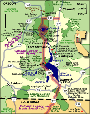
Chemult, Oregon
Chemult is an unincorporated community in Klamath County, Oregon, United States, on U.S. Route 97. Chemult has a population of about 300 people. Chemult's elevation is ....
, the byway heads west on Oregon Route 138 before turning south on Oregon Route 209
Oregon Route 209
Oregon Route 209 was an Oregon state highway that joined Oregon Route 58 at the Crescent Lake Junction and Crater Lake National Park. It was eliminated in the 1950s....
into Crater Lake National Park
Crater Lake National Park
Crater Lake National Park is a United States National Park located in southern Oregon. Established in 1902, Crater Lake National Park is the sixth oldest national park in the United States and the only one in the state of Oregon...
, where Crater Lake
Crater Lake
Crater Lake is a caldera lake located in the south-central region of the U.S. state of Oregon. It is the main feature of Crater Lake National Park and famous for its deep blue color and water clarity. The lake partly fills a nearly deep caldera that was formed around 7,700 years agoby the...
fills the caldera
Caldera
A caldera is a cauldron-like volcanic feature usually formed by the collapse of land following a volcanic eruption, such as the one at Yellowstone National Park in the US. They are sometimes confused with volcanic craters...
of the destroyed Mount Mazama
Mount Mazama
Mount Mazama is a destroyed stratovolcano in the Oregon part of the Cascade Volcanic Arc and the Cascade Range. The volcano's collapsed caldera holds Crater Lake, and the entire mountain is located within Crater Lake National Park....
volcano. The byway includes Rim Drive which circumnavigates the lake.
South of Crater Lake, the byway continues down Oregon Route 62, with Mount Scott on the east, to Fort Klamath
Fort Klamath, Oregon
Fort Klamath was a military outpost near the western end of the Oregon Trail, between Crater Lake National Park and Upper Klamath Lake in Klamath County, Oregon, United States. The Fort Klamath Site, about a mile southeast of the present community of Fort Klamath, Oregon, is listed on the U.S...
, whereupon it heads west on Weed Road to Sevenmile Road, then south on West Side Road along the edge of the Upper Klamath National Wildlife Refuge
Upper Klamath National Wildlife Refuge
The Upper Klamath National Wildlife Refuge is a wildlife refuge located in southwestern Klamath County on the shores of Upper Klamath Lake in Oregon. It was established in 1928 and contains some of freshwater marshes. It is accessible only by boat...
and Upper Klamath Lake
Upper Klamath Lake
Upper Klamath Lake is a large, shallow freshwater lake east of the Cascade Range in south central Oregon in the United States. The largest freshwater body in Oregon, it is approximately 20 mi long and 8 mi wide and extends northwest from the city of Klamath Falls...
. The byway then passes Mount McLoughlin
Mount McLoughlin
Mount McLoughlin is a steep-sided lava cone built on top of a shield volcano in the Cascade Range of southern Oregon and within the Sky Lakes Wilderness area. It is one of the volcanic peaks in the Cascade Volcanic Arc. The mountain is north of Mount Shasta, south of Crater Lake, and west of Upper...
on the east as it joins Oregon Route 140 to Klamath Falls
Klamath Falls, Oregon
Klamath Falls is a city in Klamath County, Oregon, United States. Originally called Linkville when George Nurse founded the town in 1867, after the Link River on whose falls this city sat, although no falls currently exist; the name was changed to Klamath Falls in 1892...
.
From there, the route proceeds southwards on US 97, between Bear Valley National Wildlife Refuge
Bear Valley National Wildlife Refuge
The Bear Valley National Wildlife Refuge is a wildlife refuge located in the southwestern part of Klamath County, Oregon, near the California border. It was established in 1978 to protect the nesting areas of Bald Eagles...
and Lower Klamath National Wildlife Refuge
Lower Klamath National Wildlife Refuge
The Lower Klamath National Wildlife Refuge is a wildlife preserve operated by the United States Fish and Wildlife Service located in the Klamath Basin along a portion of the northern California and southern Oregon border near Klamath Falls, Oregon...
to the California border.
California section
Spur route
A spur route is a short road forming a branch from a longer, more important route . A bypass or beltway is never considered a true spur route as it typically reconnects with the major road...
heads east on State Route 161 and south on Route 139
California State Route 139
State Route 139 is a state highway in the U.S. state of California. Running from Susanville north to Oregon Route 39, it forms part of the shortest route between Reno, Nevada and Klamath Falls, Oregon. The entire route is part of the California Freeway and Expressway System, but is a two-lane road...
to Tulelake
Tulelake, California
Tulelake is a city in Siskiyou County, California, United States. It is named after the nearby Tule Lake. The population was 1,010 at the 2010 census, down from 1,020 at the 2000 census.-Geography:Tulelake is located at ....
. This section then turns west through the town along E Street/East West Road, then south down Hill Road through the Tule Lake National Wildlife Refuge
Tule Lake National Wildlife Refuge
The Tule Lake National Wildlife Refuge is a wildlife preserve operated by the United States Fish and Wildlife Service located in the Klamath Basin in northern California near the Oregon border south of Klamath Falls, Oregon....
on the western shore of Tule Lake
Tule Lake
Tule Lake is an intermittent lake covering an area of , long and across, in northeastern Siskiyou County and northwestern Modoc County in California, along the border with Oregon.-Geography:Tule Lake is fed by the Lost River...
, an area of wetland
Wetland
A wetland is an area of land whose soil is saturated with water either permanently or seasonally. Wetlands are categorised by their characteristic vegetation, which is adapted to these unique soil conditions....
s and marsh
Marsh
In geography, a marsh, or morass, is a type of wetland that is subject to frequent or continuous flood. Typically the water is shallow and features grasses, rushes, reeds, typhas, sedges, other herbaceous plants, and moss....
es, which greatly contrast with the harsh landscape of the Lava Beds National Monument
Lava Beds National Monument
Lava Beds National Monument is located in northeastern California, in Siskiyou and Modoc Counties. The Monument lies on the northeastern flank of the Medicine Lake Volcano, with the largest total area covered by a volcano in the Cascade Range....
, just ahead. The monument lies on the northeast flank of the Medicine Lake Volcano
Medicine Lake Volcano
Medicine Lake Volcano is a large shield volcano in northeastern California about northeast of Mount Shasta. The volcano is located in a zone of east-west crustal extension east of the main axis of the Cascade Volcanic Arc and the Cascade Range. The thick shield is from east to west and from...
, the largest volcano (total area covered) in the Cascades.
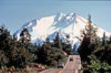
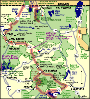
The main byway continues south on US 97 around Mount Shasta
Mount Shasta
Mount Shasta is located at the southern end of the Cascade Range in Siskiyou County, California and at is the second highest peak in the Cascades and the fifth highest in California...
, the second-tallest volcano in the country, to the city of Weed
Weed, California
Weed is a city located in Siskiyou County, California. As of the 2010 Census, the town had a total population of 2,967, down from 2,979 at the 2000 census. There are several unincorporated communities adjacent to, or just outside Weed proper. These include Edgewood, Carrick, Lake Shastina, Rancho...
, which is marked by a large totem pole that stands off of the intersection of Hwy 97 and Weed Blvd. Along Hwy 97 just north of Weed is Pluto's Cave, a collapsed lava tube that individuals can explore on their own. It then briefly joins Interstate 5, passing Black Butte, before heading east on Route 89
California State Route 89
State Route 89 is a California State Highway that travels in the north–south direction, and is the major thoroughfare for many mountain communities. It starts from U.S. Route 395 near Topaz Lake, winding its way up to the Monitor Pass, down to the Carson River, and up again over the Luther...
in the city of Mount Shasta
Mount Shasta, California
Mount Shasta is a city in Siskiyou County, California, located at around 3,600 ft on the flanks of Mount Shasta, a prominent northern California landmark. The city is less than southwest of the summit of its namesake volcano...
and heads on out to McCloud.
Besides volcanoes, the byway passes near a number of waterfall
Waterfall
A waterfall is a place where flowing water rapidly drops in elevation as it flows over a steep region or a cliff.-Formation:Waterfalls are commonly formed when a river is young. At these times the channel is often narrow and deep. When the river courses over resistant bedrock, erosion happens...
s. The McCloud River Falls are north of Lake McCloud
Lake McCloud
Lake McCloud is a reservoir on the McCloud River in Northern California. The lake forms behind an earthen dam finished in 1965 by the Pacific Gas and Electric Company to control water flows and for generating hydro-electric power...
, which lies south of the highway, near the town of McCloud
McCloud, California
McCloud is a small town and census-designated place in Siskiyou County, California, United States. The population was 1,101 at the 2010 census, down from 1,343 at the 2000 census.-Commerce and tourism:...
. McArthur-Burney Falls Memorial State Park
McArthur-Burney Falls Memorial State Park
Located approximately 6 miles north of Burney, California, McArthur-Burney Falls Memorial State Park is the second oldest state park in the California State Parks System. The park offers camping, fishing, watersports, hiking and horseback riding facilities. The park is mainly known for the...
is further along Route 89 at Lake Britton
Lake Britton
Lake Britton is a reservoir located in Shasta County, California. It is known for its wide variety of bass and trout. It is situated to the west of State Route 89, and is surrounded mostly by McArthur-Burney Falls Memorial State Park, and runs along North Shore campgrounds and Dusty Campgrounds. It...
.
Passing by a number of smaller volcanoes, Burney Mountain and Sugarloaf Peak , the byway makes it way south where it circles Lassen Peak
Lassen Peak
Lassen Peak is the southernmost active volcano in the Cascade Range. It is part of the Cascade Volcanic Arc which is an arc that stretches from northern California to southwestern British Columbia...
. At Route 44
California State Route 44
State Route 44 is a state highway in the U.S. State of California that travels in an east–west direction from Redding to Lassen Volcanic National Park before ending at Route 36 west of Susanville...
, the byway heads southeast to Route 36
California State Route 36
State Route 36 is an east–west state highway in the U.S. state of California that is routed from U.S. Route 101 in Humboldt County to U.S. Route 395 just east of Susanville in Lassen County. The portion of SR 36 travelling past Lassen Volcanic National Park and Lake Almanor is part of the...
, where it turns west. There is also a bypass along Route 147
California State Route 147
State Route 147 is a state highway in the U.S. state of California. The route runs along the eastern side of Lake Almanor. It serves as a bypass to connect State Route 89 and State Route 36 on the eastern side of the lake, whereas the two highways already meet on the western side in...
and Route 89 around Lake Almanor
Lake Almanor
Lake Almanor is a large artificial lake in northwestern Plumas County, northeastern California. The reservoir has a capacity of and a maximum depth of about 90 feet...
, rejoining Route 36 in the town of Chester
Chester, California
Chester is a census-designated place in Plumas County, California, United States. Chester is located on Lake Almanor, north-northwest of Quincy. The town is located along State Route 36. The US Postal Service ZIP code for the community is 96020...
. The byway continues along Routes 36/89 and follows Route 89 after they split through Lassen Volcanic National Park
Lassen Volcanic National Park
Lassen Volcanic National Park is a United States National Park in northeastern California. The dominant feature of the park is Lassen Peak; the largest plug dome volcano in the world and the southern-most volcano in the Cascade Range...
. On the other side of the park, Route 89 joins Route 44 eastward, returning to the starting point of the loop. This loop itself is designated the Lassen Scenic Byway.