
Villa Guerrero
Encyclopedia
The municipality of Villa Guerrero is located in the north of the state of Jalisco
, México
, between 103°22'30 and 103°50'00 longitude west and 21°54'00 and 22°10'00 latitude north, at an altitude of 1767 metres (5,797.2 ft) above sea level.
The municipality shares its border on the north with the state of Zacatecas
and the municipality of Mezquitic
, to the south with the municipalities of Bolaños
and Chimaltitán. To the east, it shares its border with the municipality of Totatiche
and to the west with the municipality of Mezquitic. The municipality covers an area of 1092 square kilometres (421.6 sq mi).
, Santa Rita, Las Adjuntas, Izolta, La Cienega de Marquez,Uribes and Patagua.
The municipality has suffered decreasing population in recent decades, largely due to emigration. In 2000, 31% of the working population was employed in agriculture and husbandry, 14% in construction, 13% in commerce and 13% in manufacturing.
). The area was conquered by the Spanish Captain Pedro Almíndez Chirino
, sent by Nuño Beltrán de Guzmán
in the year 1530. Shortly after the arrival of the Spanish into the area, the Huichol (Wixarika) migrated to the area's remote canyons and mountains. The Spanish settlement of the area at the end of the 16th century brought a number of Tlaxcaltec
colonizers to the area.
The oldest Spanish land grant in the area was in 1579 to Luis de los Rios Proaño. The grant was for approximately 120 km² in the valley of Juanacatic (from the indigenous name for the valley: Xoncacatic, meaning place of the onions). Missions were founded by the Franciscans in the area in the latter years of the 16th century. In the early 17th century, the area was the scene of a number of indigenous uprisings, including one by the Wixarika and Tepecan in 1607, resulting in its abandonment by the few Spanish settlers. In 1622, the descendants of the original grantee took interest once again in the land, seeking out titles in Zacatecas
. The land was eventually sold to Captain Juan de Escobedo and Captain Juan Diaz de Infante. Around 1673, European settlement in the region was still limited, with only one agricultural hacienda in the region known as Juanacatic.
In 1676, the Spanish military administrator for the region of Colotlán Toribio González de Escalante, began the extraction of saltpeter
in the valley. From this activity, the place gained the name of El Salitre. Eventually the extraction of saltpeter ceased due to its cost inefficiency and the administrator's inability to retain sufficient labor.
In 1702, the Tepehuan and Wixarika from the nearby mountains and canyons joined forces in a rebellion. The result was an ajudication by the Spanish Crown that forced the major Spanish landowner, Ana de Santiago, widow of Juan Diaz de Infante, to trade some of her agricultural land in the plateau for land in the canyon. Thus the Tepehuan regained part of their historic lands in a location known as Patahua. The Tepehuan community received an official grant for the land in 1733.
In 1779, the Juanacatic hacienda was acquired by Pedro de Llanos y Valdés as the area began to experience large flows of European immigration. Agricultural activity and husbandry benefited from the mining activities in nearby Bolaños
, which had begun large scale production in the 1730s. El Salitre became a regular stopover of the mule trains that transported the ore out of the canyon.
There were several battles in 1810 during the war for independence fought in the region. Many of the local indigenous groups, including the Wixarika fought on the side of the Spanish Crown.
Political reforms, such as the Iguala Plan undertaken in 1821 by the newly independent government extinguished separate treatment of indigenuos communities and communal lands of the Tepehuan were distributed to individuals. In 1838, the area was made part of the 8th Canton of the free and sovereign state of Jalisco, within the Mexican Republic and was assigned to the municipality of Totatiche
within that canton.
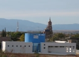
Construction on a stone church to replace the adobe chapel of the town of El Salitre began in 1905. The work was completed nearly two decades later, following the Mexican Revolution
. Soon thereafter, in 1921, the municipailty was separated from the municipality of Totatiche and declared an independent municipality by the state legislature and renamed Villa Guerrero in honor of Vicente Guerrero
.
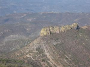 The most common type of terrain in the municipality is mountainous (46%) followed by plains (34%) and rolling hills (20%). The altitudes in the municipality vary greatly, ranging from 900 to 2,100 meters (2,950–6,900) above sea level. Their highest elevations are: in the north, Mount of the Cross (Cerro de la Cruz), to the west, White Deer Mountain (Cerro del Venado Blanco), the Toril Mesa
and the Chihuahua Mesa; to the south and southeast, Pine Mountain (Cerro del Pino) and Thistles Mountain (Cerro de los Cardos).
 In the highest altitude zones there are natural forests composed of pine
. In the lower altitudes, oak
and live oak
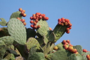
trees dominate. In the hills and lower altitudes there are cacti
, acacia
, Arizona kidneywood and other plant species. The foothills and the plains are covered by natural grass
es.
s, hare
s, deer
, reptile
s, mountain lions and other smaller species inhabit in this region.
Jalisco
Jalisco officially Estado Libre y Soberano de Jalisco is one of the 31 states which, with the Federal District, comprise the 32 Federal Entities of Mexico. It is located in Western Mexico and divided in 125 municipalities and its capital city is Guadalajara.It is one of the more important states...
, México
Mexico
The United Mexican States , commonly known as Mexico , is a federal constitutional republic in North America. It is bordered on the north by the United States; on the south and west by the Pacific Ocean; on the southeast by Guatemala, Belize, and the Caribbean Sea; and on the east by the Gulf of...
, between 103°22'30 and 103°50'00 longitude west and 21°54'00 and 22°10'00 latitude north, at an altitude of 1767 metres (5,797.2 ft) above sea level.
The municipality shares its border on the north with the state of Zacatecas
Zacatecas
Zacatecas officially Estado Libre y Soberano de Zacatecas is one of the 31 states which, with the Federal District, comprise the 32 Federal Entities of Mexico. It is divided in 58 municipalities and its capital city is Zacatecas....
and the municipality of Mezquitic
Mezquitic
Mezquitic is a town and municipality in the north of the state of Jalisco, Mexico.It is bordered to the north east and west by the state of Zacatecas...
, to the south with the municipalities of Bolaños
Bolaños
The municipality of Bolaños is located in the north of the Mexican state of Jalisco.The municipality shares its border on the north with the municipalities of Mezquitic and Villa Guerrero and to the southeast with the municipality of Chimaltitán...
and Chimaltitán. To the east, it shares its border with the municipality of Totatiche
Totatiche
The municipality and town of Totatiche is located in the northern extreme of the state of Jalisco, Mexico between 21°48’30” and 22°06’00” latitude north and 103°20’00” and 103°34’00” longitude east at a height of above sea level. The municipality is bordered on the north and southeast by the...
and to the west with the municipality of Mezquitic. The municipality covers an area of 1092 square kilometres (421.6 sq mi).
Population
The population of the municipality in 2005 was 5,182 inhabitants, of which 3,503 lived in the municipal seat of Villa Guerrero. The remaining population was spread throughout the rural areas within the municipality's borders. Some other notable localities within these borders include Ojo de Agua, AzqueltánAzqueltán
Azqueltán is a small settlement located on the banks of the Bolaños River in the municipality of Villa Guerrero, Jalisco, Mexico. "Azqueltán" means "place of the ants" in the Tepehuán language....
, Santa Rita, Las Adjuntas, Izolta, La Cienega de Marquez,Uribes and Patagua.
The municipality has suffered decreasing population in recent decades, largely due to emigration. In 2000, 31% of the working population was employed in agriculture and husbandry, 14% in construction, 13% in commerce and 13% in manufacturing.
History
Prior to the Spanish conquest, the municipality of Villa Guerrero was inhabited by the indigenous Tepecan (TepehuanTepehuán
The Tepehuán are a Native American ethnic group in northwest Mexico, whose villages at the time of Spanish conquest spanned a large territory along the Sierra Madre Occidental from Chihuahua and Durango in the north to Jalisco in the south...
). The area was conquered by the Spanish Captain Pedro Almíndez Chirino
Pedro Almíndez Chirino
Pedro Almíndez Chirino was a conquistador and member of several councils that governed New Spain while Hernán Cortés was traveling to Honduras, in 1525-26...
, sent by Nuño Beltrán de Guzmán
Nuño Beltrán de Guzmán
Nuño Beltrán de Guzmán or sometimes Nuño de Guzmán was a Spanish conquistador and colonial administrator in New Spain. He was Governor of the province of Pánuco from 1525–1533, and of Nueva Galicia from 1529–1534, President of the first Audiencia from 1528-30. He founded several cities in...
in the year 1530. Shortly after the arrival of the Spanish into the area, the Huichol (Wixarika) migrated to the area's remote canyons and mountains. The Spanish settlement of the area at the end of the 16th century brought a number of Tlaxcaltec
Tlaxcaltec
The Tlaxcalteca were an indigenous group of Nahua ethnicity that inhabited the Kingdom of Tlaxcala located in what is now the Mexican state of Tlaxcala.-Pre-hispanic history:...
colonizers to the area.
The oldest Spanish land grant in the area was in 1579 to Luis de los Rios Proaño. The grant was for approximately 120 km² in the valley of Juanacatic (from the indigenous name for the valley: Xoncacatic, meaning place of the onions). Missions were founded by the Franciscans in the area in the latter years of the 16th century. In the early 17th century, the area was the scene of a number of indigenous uprisings, including one by the Wixarika and Tepecan in 1607, resulting in its abandonment by the few Spanish settlers. In 1622, the descendants of the original grantee took interest once again in the land, seeking out titles in Zacatecas
Zacatecas, Zacatecas
Zacatecas is a city and municipality in Mexico and the capital of the state of Zacatecas. It is located in the north central part of the country. The city had its start as a Spanish mining camp in the mid 16th century. Prior to this, the area's rich deposits in silver and other minerals were known...
. The land was eventually sold to Captain Juan de Escobedo and Captain Juan Diaz de Infante. Around 1673, European settlement in the region was still limited, with only one agricultural hacienda in the region known as Juanacatic.
In 1676, the Spanish military administrator for the region of Colotlán Toribio González de Escalante, began the extraction of saltpeter
Potassium nitrate
Potassium nitrate is a chemical compound with the formula KNO3. It is an ionic salt of potassium ions K+ and nitrate ions NO3−.It occurs as a mineral niter and is a natural solid source of nitrogen. Its common names include saltpetre , from medieval Latin sal petræ: "stone salt" or possibly "Salt...
in the valley. From this activity, the place gained the name of El Salitre. Eventually the extraction of saltpeter ceased due to its cost inefficiency and the administrator's inability to retain sufficient labor.
In 1702, the Tepehuan and Wixarika from the nearby mountains and canyons joined forces in a rebellion. The result was an ajudication by the Spanish Crown that forced the major Spanish landowner, Ana de Santiago, widow of Juan Diaz de Infante, to trade some of her agricultural land in the plateau for land in the canyon. Thus the Tepehuan regained part of their historic lands in a location known as Patahua. The Tepehuan community received an official grant for the land in 1733.
In 1779, the Juanacatic hacienda was acquired by Pedro de Llanos y Valdés as the area began to experience large flows of European immigration. Agricultural activity and husbandry benefited from the mining activities in nearby Bolaños
Bolaños
The municipality of Bolaños is located in the north of the Mexican state of Jalisco.The municipality shares its border on the north with the municipalities of Mezquitic and Villa Guerrero and to the southeast with the municipality of Chimaltitán...
, which had begun large scale production in the 1730s. El Salitre became a regular stopover of the mule trains that transported the ore out of the canyon.
There were several battles in 1810 during the war for independence fought in the region. Many of the local indigenous groups, including the Wixarika fought on the side of the Spanish Crown.
Political reforms, such as the Iguala Plan undertaken in 1821 by the newly independent government extinguished separate treatment of indigenuos communities and communal lands of the Tepehuan were distributed to individuals. In 1838, the area was made part of the 8th Canton of the free and sovereign state of Jalisco, within the Mexican Republic and was assigned to the municipality of Totatiche
Totatiche
The municipality and town of Totatiche is located in the northern extreme of the state of Jalisco, Mexico between 21°48’30” and 22°06’00” latitude north and 103°20’00” and 103°34’00” longitude east at a height of above sea level. The municipality is bordered on the north and southeast by the...
within that canton.
Construction on a stone church to replace the adobe chapel of the town of El Salitre began in 1905. The work was completed nearly two decades later, following the Mexican Revolution
Mexican Revolution
The Mexican Revolution was a major armed struggle that started in 1910, with an uprising led by Francisco I. Madero against longtime autocrat Porfirio Díaz. The Revolution was characterized by several socialist, liberal, anarchist, populist, and agrarianist movements. Over time the Revolution...
. Soon thereafter, in 1921, the municipailty was separated from the municipality of Totatiche and declared an independent municipality by the state legislature and renamed Villa Guerrero in honor of Vicente Guerrero
Vicente Guerrero
Vicente Ramón Guerrero Saldaña was one of the leading revolutionary generals of the Mexican War of Independence, who fought against Spain for independence in the early 19th century, and served briefly as President of Mexico...
.
Orography
Mesa
A mesa or table mountain is an elevated area of land with a flat top and sides that are usually steep cliffs. It takes its name from its characteristic table-top shape....
and the Chihuahua Mesa; to the south and southeast, Pine Mountain (Cerro del Pino) and Thistles Mountain (Cerro de los Cardos).
Hydrography
The municipality's hydrologic resources are provided mainly by the Bolaños River. Other larger streams with permantent flow include: Sataray River, Blue Puddle (Charco Azul) River and La Villa River. There are also streams with seasonal flow, including: Chihuahua Creek, Nogales Creek, Zacatequillas Creek, New Water (Agua Nueva) Creek, Rinconada Creek, La Labor Creek, Las Planillas Creek and Juanacatic CreekClimate
The municipality's climate is semiarid, with dry winters and springs, and a temperate and dry winter without a well defined spring season. The annual average temperature is of 18.7 °C (66 °F), with a high of 27.6 °C (82 °F) and low of 9.8 °C (50 °F). Rainy season occurs in the months of June, July and August, and includes an average rainfall of 803.2 millimetres (31.6 in). There are an annual average of 11 days of frost. The dominant winds are in direction of the southeast.Vegetation and Flora
Pine
Pines are trees in the genus Pinus ,in the family Pinaceae. They make up the monotypic subfamily Pinoideae. There are about 115 species of pine, although different authorities accept between 105 and 125 species.-Etymology:...
. In the lower altitudes, oak
Oak
An oak is a tree or shrub in the genus Quercus , of which about 600 species exist. "Oak" may also appear in the names of species in related genera, notably Lithocarpus...
and live oak
Live oak
Live oak , also known as the southern live oak, is a normally evergreen oak tree native to the southeastern United States...
trees dominate. In the hills and lower altitudes there are cacti
Cactus
A cactus is a member of the plant family Cactaceae. Their distinctive appearance is a result of adaptations to conserve water in dry and/or hot environments. In most species, the stem has evolved to become photosynthetic and succulent, while the leaves have evolved into spines...
, acacia
Acacia
Acacia is a genus of shrubs and trees belonging to the subfamily Mimosoideae of the family Fabaceae, first described in Africa by the Swedish botanist Carl Linnaeus in 1773. Many non-Australian species tend to be thorny, whereas the majority of Australian acacias are not...
, Arizona kidneywood and other plant species. The foothills and the plains are covered by natural grass
Grass
Grasses, or more technically graminoids, are monocotyledonous, usually herbaceous plants with narrow leaves growing from the base. They include the "true grasses", of the Poaceae family, as well as the sedges and the rushes . The true grasses include cereals, bamboo and the grasses of lawns ...
es.
Fauna
RabbitRabbit
Rabbits are small mammals in the family Leporidae of the order Lagomorpha, found in several parts of the world...
s, hare
Hare
Hares and jackrabbits are leporids belonging to the genus Lepus. Hares less than one year old are called leverets. Four species commonly known as types of hare are classified outside of Lepus: the hispid hare , and three species known as red rock hares .Hares are very fast-moving...
s, deer
Deer
Deer are the ruminant mammals forming the family Cervidae. Species in the Cervidae family include white-tailed deer, elk, moose, red deer, reindeer, fallow deer, roe deer and chital. Male deer of all species and female reindeer grow and shed new antlers each year...
, reptile
Reptile
Reptiles are members of a class of air-breathing, ectothermic vertebrates which are characterized by laying shelled eggs , and having skin covered in scales and/or scutes. They are tetrapods, either having four limbs or being descended from four-limbed ancestors...
s, mountain lions and other smaller species inhabit in this region.
Land Use
The composition of the municipality's soil includes Haplic Feozem, Regosol and Chromic Luvisol. The municipality has a territorial surface of 1,092.03 km² (269,846 acres), of which 282.98 km² (69,926 acres) are utilized for agriculture, 2,330.26 km² (575,820 acres) in livestock activities, 500 km² (123,553 acres) for forestry. Urban areas cover 0.3 km² (74 acres) and 75.73 km² have other uses. 1047.03 km² (258,727 acres) are owned by private parties and 45 km² (11,120 acres) are communal property.External links
- Villa Guerrero Social Network website
- Tony Cordero Photography of Villa Guerrero
- History and Explanation of Villa Guerrero Coat of Arms
Sources
- Enciclopedia de los Municipios de México, State of Jalisco http://www.e-local.gob.mx/work/templates/enciclo/jalisco/mpios/14115a.htm
- Robert Dennis Shadow, Tierra Trabajo y Ganado en la Region Norte de Jalisco
- Nicolas Valdés Huerta, Historia de Villa Guerrero
- Insituto Nacional de Estadística, Geografía e Informática http://www.inegi.gob.mx
- Sistema de información del Estado de Jalisco http://seijal.jalisco.gob.mx