
Bolaños
Encyclopedia
The municipality of Bolaños is located in the north of the Mexican
state of Jalisco
.
The municipality shares its border on the north with the municipalities of Mezquitic
and Villa Guerrero and to the southeast with the municipality of Chimaltitán. To the south, it shares a border with the municipality of San Martín de Bolaños
and to the southwest, it shares a border with the state of Nayarit
.
which is an autonomous Wixárika (Huichol) village with a population of 944 inhabitants. The municipality suffers one of the highest poverty rates in the state of Jalisco. More than 48 percent of its inhabitants spoke an indigenous language according to the census. Most of these would be speakers of Huichol who inhabit one of the numerous indigenous communities within the borders of the municipality, including Tuxpán de Bolaños
.
Of the economically active population, the largest group is employed in agriculture and husbandry (21 percent). The second largest group is employed in industry and manufacturing (15 percent), followed by mining (13 percent).
 Prior to the Spanish conquest, the municipality of Bolaños was inhabited by the indigenous Tepecan (Tepehuan
). The area was conquered by the Spanish Captain Pedro Almíndez Chirino
, sent by Nuño Beltrán de Guzmán
in the year 1530. Shortly after the arrival of the Spanish into the area, the Huichol (Wixarika) migrated to the area's remote canyons and mountains.
The original Spanish land grantee in the region was Toribio de Bolaños, in whose honor the municipality was named. In 1548, he received a trusteeship (encomienda) for all of the indigenous inhabitants of the area and the right to mine silver. The mining operations lasted only a few years before they were shut down by indigenous rebellions. The area was not resettled until the early 17th century when the Franciscan
s founded a mission in Chimaltitán.
In 1730, a new vein of silver was discovered and a new mining camp was established near the existing camps of Tepec and Santa Rosa Alburquerque. In 1748, yet another vein was discovered near the old Bolaños mine by an indigenous man named José Barranco. Other mining discoveries included: La Cocina; la del Espíritu Santo, llamada también La Conejera; El Parián; El Barranco o de La Conquista; La Castellana; La Perla; Zapopan; La Montañesa; Los Laureles; y La Trinidad. Until 1780, Bolaños was one of the top three mining regions in New Spain.
The mining population in Bolaños reached upwards of 1,500 mine workers plus all of the ancillary labor. In 1792, the mines produced 120,166 marks and 4 ounces of silver. Around 1830, silver production dropped off dramatically, leading to a general economic depression in the region.
After the War of Independence
, Bolaños was assigned to the 8th canton of the free and sovereign state of Jalisco. A decree published on 19 February 1833 officially made the Bolaños a municipality.
Mexico
The United Mexican States , commonly known as Mexico , is a federal constitutional republic in North America. It is bordered on the north by the United States; on the south and west by the Pacific Ocean; on the southeast by Guatemala, Belize, and the Caribbean Sea; and on the east by the Gulf of...
state of Jalisco
Jalisco
Jalisco officially Estado Libre y Soberano de Jalisco is one of the 31 states which, with the Federal District, comprise the 32 Federal Entities of Mexico. It is located in Western Mexico and divided in 125 municipalities and its capital city is Guadalajara.It is one of the more important states...
.
The municipality shares its border on the north with the municipalities of Mezquitic
Mezquitic
Mezquitic is a town and municipality in the north of the state of Jalisco, Mexico.It is bordered to the north east and west by the state of Zacatecas...
and Villa Guerrero and to the southeast with the municipality of Chimaltitán. To the south, it shares a border with the municipality of San Martín de Bolaños
San Martín de Bolaños
San Martín de Bolaños is a town and municipality, in Jalisco in central-western Mexico. The municipality covers an area of 991.99 km².As of 2005, the municipality had a total population of 3,205....
and to the southwest, it shares a border with the state of Nayarit
Nayarit
Nayarit officially Estado Libre y Soberano de Nayarit is one of the 31 states which, with the Federal District, comprise the 32 Federal Entities of Mexico. It is divided in 20 municipalities and its capital city is Tepic.It is located in Western Mexico...
.
Climate
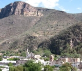
Bolaños is surrounded with mountains and semi-desert and due to its topographical position in the canyon, Bolaños is often very hot. Bolaños is frequently one of the hottest spots in Mexico during the summer months, April–June with maximum temperature as high as 55 celsius and in nighttime it can drop to only 7 celsius. In the winter it can drop as low as -27 celsius and in daytime high as 27 celsius.Population
The population of Bolaños totaled 5,019 inhabitants according to the 2005 census. Of these, 826 lived in the municipal seat and the remainder lived in other communities within the municipality. The community with the largest population within the municipality is not the municipal seat, but rather Tuxpán de BolañosTuxpan de Bolaños
Tuxpán de Bolaños is an autonomously governed Wixárika village located in Bolaños, Jalisco, Mexico. The village is called Tutsipa in the native Wixárika language. The village is located at 21.5229 degrees latitude North and 104.0047 degrees longitude West. It rests at an altitude of 1,120...
which is an autonomous Wixárika (Huichol) village with a population of 944 inhabitants. The municipality suffers one of the highest poverty rates in the state of Jalisco. More than 48 percent of its inhabitants spoke an indigenous language according to the census. Most of these would be speakers of Huichol who inhabit one of the numerous indigenous communities within the borders of the municipality, including Tuxpán de Bolaños
Tuxpan de Bolaños
Tuxpán de Bolaños is an autonomously governed Wixárika village located in Bolaños, Jalisco, Mexico. The village is called Tutsipa in the native Wixárika language. The village is located at 21.5229 degrees latitude North and 104.0047 degrees longitude West. It rests at an altitude of 1,120...
.
Of the economically active population, the largest group is employed in agriculture and husbandry (21 percent). The second largest group is employed in industry and manufacturing (15 percent), followed by mining (13 percent).
History
Tepehuán
The Tepehuán are a Native American ethnic group in northwest Mexico, whose villages at the time of Spanish conquest spanned a large territory along the Sierra Madre Occidental from Chihuahua and Durango in the north to Jalisco in the south...
). The area was conquered by the Spanish Captain Pedro Almíndez Chirino
Pedro Almíndez Chirino
Pedro Almíndez Chirino was a conquistador and member of several councils that governed New Spain while Hernán Cortés was traveling to Honduras, in 1525-26...
, sent by Nuño Beltrán de Guzmán
Nuño Beltrán de Guzmán
Nuño Beltrán de Guzmán or sometimes Nuño de Guzmán was a Spanish conquistador and colonial administrator in New Spain. He was Governor of the province of Pánuco from 1525–1533, and of Nueva Galicia from 1529–1534, President of the first Audiencia from 1528-30. He founded several cities in...
in the year 1530. Shortly after the arrival of the Spanish into the area, the Huichol (Wixarika) migrated to the area's remote canyons and mountains.
The original Spanish land grantee in the region was Toribio de Bolaños, in whose honor the municipality was named. In 1548, he received a trusteeship (encomienda) for all of the indigenous inhabitants of the area and the right to mine silver. The mining operations lasted only a few years before they were shut down by indigenous rebellions. The area was not resettled until the early 17th century when the Franciscan
Franciscan
Most Franciscans are members of Roman Catholic religious orders founded by Saint Francis of Assisi. Besides Roman Catholic communities, there are also Old Catholic, Anglican, Lutheran, ecumenical and Non-denominational Franciscan communities....
s founded a mission in Chimaltitán.
In 1730, a new vein of silver was discovered and a new mining camp was established near the existing camps of Tepec and Santa Rosa Alburquerque. In 1748, yet another vein was discovered near the old Bolaños mine by an indigenous man named José Barranco. Other mining discoveries included: La Cocina; la del Espíritu Santo, llamada también La Conejera; El Parián; El Barranco o de La Conquista; La Castellana; La Perla; Zapopan; La Montañesa; Los Laureles; y La Trinidad. Until 1780, Bolaños was one of the top three mining regions in New Spain.
The mining population in Bolaños reached upwards of 1,500 mine workers plus all of the ancillary labor. In 1792, the mines produced 120,166 marks and 4 ounces of silver. Around 1830, silver production dropped off dramatically, leading to a general economic depression in the region.
After the War of Independence
Mexican War of Independence
The Mexican War of Independence was an armed conflict between the people of Mexico and the Spanish colonial authorities which started on 16 September 1810. The movement, which became known as the Mexican War of Independence, was led by Mexican-born Spaniards, Mestizos and Amerindians who sought...
, Bolaños was assigned to the 8th canton of the free and sovereign state of Jalisco. A decree published on 19 February 1833 officially made the Bolaños a municipality.
Sources
- Enciclopedia de los Municipios del Estado de Jalisco http://www.e-local.gob.mx/work/templates/enciclo/jalisco/mpios/14019a.htm
- Nicolas Valdes Huerta, Historia de Villa Guerrero
- Instituto Nacional de Estadística, Geografía e Informática http://www.inegi.gob.mx