

Vallum (Hadrian's Wall)
Encyclopedia
Hadrian's Wall
Hadrian's Wall was a defensive fortification in Roman Britain. Begun in AD 122, during the rule of emperor Hadrian, it was the first of two fortifications built across Great Britain, the second being the Antonine Wall, lesser known of the two because its physical remains are less evident today.The...
in England
England
England is a country that is part of the United Kingdom. It shares land borders with Scotland to the north and Wales to the west; the Irish Sea is to the north west, the Celtic Sea to the south west, with the North Sea to the east and the English Channel to the south separating it from continental...
. Unique on any Roman
Roman Empire
The Roman Empire was the post-Republican period of the ancient Roman civilization, characterised by an autocratic form of government and large territorial holdings in Europe and around the Mediterranean....
frontier, it runs from coast to coast to the south of the wall.
The earliest surviving mention of the earthwork is by Bede
Bede
Bede , also referred to as Saint Bede or the Venerable Bede , was a monk at the Northumbrian monastery of Saint Peter at Monkwearmouth, today part of Sunderland, England, and of its companion monastery, Saint Paul's, in modern Jarrow , both in the Kingdom of Northumbria...
(Historia
Historia ecclesiastica gentis Anglorum
The Historia ecclesiastica gentis Anglorum is a work in Latin by Bede on the history of the Christian Churches in England, and of England generally; its main focus is on the conflict between Roman and Celtic Christianity.It is considered to be one of the most important original references on...
, I.12), who refers to a vallum
Vallum
Vallum is a term applied either to the whole or a portion of the fortifications of a Roman camp. The vallum usually comprised an earthen or turf rampart with a wooden palisade on top, with a deep outer ditch...
, or earthen rampart, as distinct from the wall, or murus; the term is still used despite the fact that the essential element is a ditch, or fossa. It was for long thought that the Vallum predated the stone wall, the most elaborate phasing being presented in 1801 by William Hutton, who thought that the south vallum mound and the marginal mound, with a ditch between, were the work of Agricola
Gnaeus Julius Agricola
Gnaeus Julius Agricola was a Roman general responsible for much of the Roman conquest of Britain. His biography, the De vita et moribus Iulii Agricolae, was the first published work of his son-in-law, the historian Tacitus, and is the source for most of what is known about him.Born to a noted...
, the vallum ditch and north mound were added by Hadrian
Hadrian
Hadrian , was Roman Emperor from 117 to 138. He is best known for building Hadrian's Wall, which marked the northern limit of Roman Britain. In Rome, he re-built the Pantheon and constructed the Temple of Venus and Roma. In addition to being emperor, Hadrian was a humanist and was philhellene in...
, and the stone wall was the work of Severus.
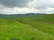
Layout and course
The Vallum comprises a ditch, nominally 6 metres (19.7 ft) wide and 3 metres (9.8 ft) deep, with a flat bottom, flanked by two mounds about 6 metres wide and 2 metres (6.6 ft) high, set back some 9 metres (29.5 ft) from the ditch edges. For a great deal of its length a third lower mound, the so-called marginal mound occupies the south berm (flat area between mound and ditch), right on the southern lip of the ditch. The total width of the fortification (consisting, from north to south, of mound, berm, ditch, marginal mound, berm, mound) was thus about 36 metres (118.1 ft).The distance of the Vallum from the Wall varies. In general there was a preference for the earthwork to run close to the rear of the Wall where topography allowed. In the central sector the Wall runs along the top of the crags of the Whin Sill
Whin Sill
The Whin Sill or Great Whin Sill is a tabular layer of the igneous rock dolerite in County Durham and Northumberland in the northeast of England. It lies partly in the North Pennines Area of Outstanding Natural Beauty and partly in Northumberland National Park and stretches from Teesdale northwards...
, while the Vallum, laid out in long straight stretches, lies in the valley below to the south, as much as 700 metres (2,296.6 ft) away.
Archaeology and purpose
Prior to the mid-19th century, the Vallum was most commonly known as Agricola's Ditch, as antiquariansAntiquarian
An antiquarian or antiquary is an aficionado or student of antiquities or things of the past. More specifically, the term is used for those who study history with particular attention to ancient objects of art or science, archaeological and historic sites, or historic archives and manuscripts...
thought that it had been constructed during the period when Agricola
Gnaeus Julius Agricola
Gnaeus Julius Agricola was a Roman general responsible for much of the Roman conquest of Britain. His biography, the De vita et moribus Iulii Agricolae, was the first published work of his son-in-law, the historian Tacitus, and is the source for most of what is known about him.Born to a noted...
was governor of Brittania, the Roman province spanning what is now England, Wales
Wales
Wales is a country that is part of the United Kingdom and the island of Great Britain, bordered by England to its east and the Atlantic Ocean and Irish Sea to its west. It has a population of three million, and a total area of 20,779 km²...
and southern Scotland
Scotland
Scotland is a country that is part of the United Kingdom. Occupying the northern third of the island of Great Britain, it shares a border with England to the south and is bounded by the North Sea to the east, the Atlantic Ocean to the north and west, and the North Channel and Irish Sea to the...
. However, after the historian and archaeologist John Hodgson published the final portion of his History of Northumberland in 1840, it became generally accepted that the Wall and Vallum had been built during the reign of Hadrian. Hodgson based his view on evidence which included a stone tablet in the Museum of Antiquities, Newcastle upon Tyne
Newcastle upon Tyne
Newcastle upon Tyne is a city and metropolitan borough of Tyne and Wear, in North East England. Historically a part of Northumberland, it is situated on the north bank of the River Tyne...
, which had been found in milecastle
Milecastle
A milecastle was a small fort , a rectangular fortification built during the period of the Roman Empire. They were placed at intervals of approximately one Roman mile along several major frontiers, for example Hadrian's Wall in Great Britain , hence the name.Along Hadrian's Wall, milecastles were...
38 on the Wall in the previous century, its significance having been overlooked. The inscription on the tablet, probably made and erected to mark the completion of the milecastle, includes the names of Hadrian and Aulus Platorius Nepos
Aulus Platorius Nepos
Aulus Platorius Nepos was a Roman politician of the early 2nd century.Platorius Nepos was governor of Germania Inferior. He was a close friend and possible kinsman of the Emperor Hadrian and may have accompanied Hadrian on his visit to Britain in 122. In this year he was made governor of Roman...
(governor of Brittania during Hadrian's reign), as well as "Legio II Augusta
Legio II Augusta
Legio secunda Augusta , was a Roman legion, levied by Gaius Vibius Pansa Caetronianus in 43 BC, and still operative in Britannia in the 4th century...
" (Second Augustan Legion
Roman legion
A Roman legion normally indicates the basic ancient Roman army unit recruited specifically from Roman citizens. The organization of legions varied greatly over time but they were typically composed of perhaps 5,000 soldiers, divided into maniples and later into "cohorts"...
). It is now accepted that units of that Roman legion built the section of Hadrian's Wall which includes the milecastle, and they would have automatically included the names of the current emperor and governor on the tablet.
The first excavation was undertaken in 1893 at Great Hill (Heddon-on-the-Wall
Heddon-on-the-Wall
Heddon-on-the-Wall is a village just outside Throckley, Northumberland, England, located on Hadrian's Wall. Heddon-on-the-Wall is roughly nine miles west of the centre of Newcastle upon Tyne...
, near Newcastle upon Tyne), where it was observed that the Vallum ditch was cut through a seam of fire-clay which was deployed in both mounds. This excavation demonstrated that the main north and south mounds were contemporary and built using material dug from the ditch. In the late 20th century several excavations established that the marginal mound was also contemporary.
The Vallum is known to have been constructed some time after the wall was completed, as it deviates to the south around several wall-forts which were either completed or under construction when the wall was nearing completion. There would have been a crossing-point like a causeway or bridge to the south of each wall-fort—several such causeways are known, such as the one at Condercum
Condercum
Condercum was a Roman fort at modern-day Benwell, a suburb of Newcastle upon Tyne, England. It was the third fort on Hadrian's Wall, after Segedunum and Pons Aelius , and was situated to the west of the city. Today, nothing can be seen of the fort or its adjoining wall, as the site is covered by...
in Benwell
Benwell
Benwell is an area in the West End of Newcastle upon Tyne, England.-History:Benwell village was recorded in A.D. 1050 known as Bynnewalle which roughly translates as "behind the wall" or "by the wall". Referring to its position relative to Hadrian's Wall...
, a suburb of Newcastle. Causeways have also been detected to the south of several milecastles
Milecastle
A milecastle was a small fort , a rectangular fortification built during the period of the Roman Empire. They were placed at intervals of approximately one Roman mile along several major frontiers, for example Hadrian's Wall in Great Britain , hence the name.Along Hadrian's Wall, milecastles were...
.
Although there is no definitive historical evidence as to why the Roman army built this unusual barrier, modern archaeological opinion is that the Vallum established the southern boundary of a military zone bounded on the north by the wall itself. The zone would have been "out-of-bounds" to civilians and those with no valid reason to be there.
Sometime in the 2nd century AD, the Vallum was "slighted"—that is, the ramparts were broken through and the ditch filled in at fairly regular intervals along its length. Archaeologists and historians have deduced that either the vallum was then deemed unnecessary, or that it was proving to be a hindrance to military and authorised civilian traffic. Some have suggested that this coincided with the building of the Antonine Wall
Antonine Wall
The Antonine Wall is a stone and turf fortification built by the Romans across what is now the Central Belt of Scotland, between the Firth of Forth and the Firth of Clyde. Representing the northernmost frontier barrier of the Roman Empire, it spanned approximately 39 miles and was about ten feet ...
in Scotland and the partial abandonment of Hadrian's Wall.