

Valles Marineris
Encyclopedia
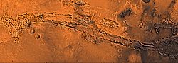
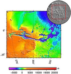
Valles Marineris is a system of canyons that runs along the Martian
surface east of the Tharsis
region. At more than 4,000 km long, 200 km wide and up to 7 km deep, the Valles Marineris rift system is one of the larger canyons of the Solar System, surpassed only by the rift valley
s of Earth and (in length only) by Baltis Vallis
on Venus.
Valles Marineris is located along the equator of Mars, on the east side of the Tharsis
Bulge, and stretches for nearly a quarter of the planet’s circumference. The Valles Marineris system starts in the west with the Noctis Labyrinthus
; proceeding to the east are Tithonium
and Ius
chasma
ta, then Melas
and Ophir
chasmata, then Coprates Chasma, then Ganges
, Capri and Eos
chasmata; finally it empties into an outflow channel region containing chaotic terrain that ends in the basin of Chryse Planitia
. Most researchers agree that Valles Marineris is a large tectonic
"crack" in the Martian crust that formed as the crust rose in the Tharsis
region to the west, and was subsequently widened by erosional forces. However, near the eastern flanks of the rift there appear to be some channels that may have been formed by water
or carbon dioxide
.
 There have been many different theories about the formation of Valles Marineris that have changed over the years. Ideas in the 1970s were erosion by water
or thermokarst
activity, which is the melting of permafrost
in glacial climes. Thermokarst activity may contribute, but erosion by water is not very likely because liquid water cannot exist in most current Martian surface conditions, which typically experience about 1% earth’s atmospheric pressure and a temperature range of 148 to 310 degrees kelvin
. However, scientists agree that there was liquid water
flowing on the Martian surface in the past. Valles Marineris may have been formed by flowing water at this time. Another hypothesis by McCauley in 1972 was that the canyons formed by withdrawal of subsurface magma. Around 1989 Tanaka and Golombek proposed a theory of formation by tensional fracturing. The most agreed upon theory today is that Valles Marineris was formed by rift faults like the East African Rift Valley
, later made bigger by erosion and collapsing of the rift walls.
Because Valles Marineris is thought to be a large rift valley, its formation is closely tied with the formation of the Tharsis
Bulge. The Tharsis Bulge was formed from the Noachian to Late Hesperian period of Mars. Tharsis was formed in three stages, appropriately named one, two and three. Stage one of the Tharsis construction consisted of a combination of volcanism and isostatic uplift; soon, however, the volcanism
loaded the crust to a point at which the crust could no longer support the added weight of Tharsis, leading to widespread graben
s in the elevated regions of Tharsis. Stage two consisted of more volcanism and a loss of isostatic equilibrium
; the source regions of the volcanism no longer resided underneath Tharsis, creating a very large load. Finally, the crust failed to hold up Tharsis and the radial fractures, like Valles Marineris, formed. Stage three mainly consisted of more volcanism and asteroid impacts. The crust, having already reached its failure point, just stayed in place and the younger volcanoes formed. Tharsis volcanism occurred at a very low viscosity magma
, forming shield volcanoes similar to the Hawaiian Island chain
, but, because there are no active plate tectonics on Mars, the hotspot activity kept loading the same spot over and over, creating some of the largest volcanoes in the solar system, including the biggest: Olympus Mons
.
, on the western edge of the Valles Marineris Rift System, north of the Syria Planum
and east of Pavonis Mons
, is a jumbled terrain composed of huge blocks which are heavily fractured. Also it contains canyons that run in different directions surrounding large blocks of older terrain. Most of the upper parts of the blocks are composed of younger fractured material thought to be of volcanic origin associated with the Tharsis Bulge. The other tops are composed of older fractured material thought also to be volcanic in origin, but differentiated from the younger material by more ruggedness and more impact craters. The sides of the blocks are composed of undivided material thought to be basement rock. The space between the blocks is composed mainly of either rough or smooth floor material. The rough floor material tends to be in the eastern portion of the Noctis Labyrinthus and is thought to be debris from the walls or maybe eolian features covering rough topography and landslides. The smooth floor material is thought to be composed of fluvial material and/or eolian features covering an otherwise rough and jumbled terrain. Terrains such as Noctis Labyrinthus are commonly found at the head of outflow channels, like the one explored by the Pathfinder mission and its Sojourner rover. They are interpreted to be a place of downward block faulting associated with the removal of ground fluid in catastrophic flood sequences. The fluid could be either carbon-dioxide ice and gas or water. Water is the prevailing theory , but Hoffman proposes carbon dioxide gas/liquid as an agent of flooding.
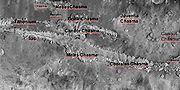
 Further to the east from Oudemans, Ius
and Tithonium
chasmata are located parallel to each other, Ius to the south and Tithonium to the north. Ius is the wider of the two, leading to Melas Chasma. Ius has a ridge down the center of it by the name of Geryon Montes, composed of the undivided basement rock. The floor of Ius Chasma is mostly composed of slide material that is really just a bunch of pristine landslides covering each other; pristine from a lack of cratering or erosion. The southern wall of Ius, and to a lesser extent the northern wall, has a lot of short valleys stretching off to the south. These valleys have a stubby theater headed leading edge very much like features seen on the Colorado Plateau near the Grand Canyon that appear from groundwater sapping
. Theater headed means that the head of the valley is a well-defined aerial U-shape that curves back under from the groundwater sapping and the valley is propagated by the continued erosion and the collapse of the wall. Tithonium Chasma is very similar to Ius, except it is lacking the sapping features on the south side and contains a small portion of stuff that is similar to the smooth floor features except that it appears to be an ash fall that has been eroded by the wind forming eolian features. Between the two canyons, the surface is composed of younger fractured material of lava flows and faults from crustal extension of the Tharsis Bulge.
, Candor
and Ophir
chasmata. Melas is east of Ius, Candor is east of Tithonium and Ophir appears as an oval that runs into Candor. All three chasmata are connected. The floor of Melas Chasma is about 70% younger massive material that is thought to be volcanic ash whipped up by the wind into eolian features. It also contains rough floor material from the erosion of the canyon walls. Also, in these central chasmata there is a portion of the floor that is higher than the rest of the floor, most likely left by the continued dropping of the other floor material. Around the edges of Melas is also a lot of slide material as seen in Ius and Tithonium chasmata. This is also the deepest part of the Valles Marineris system at eleven kilometers below the surrounding surface; from here the outflow channels are about a 0.03 degree slope upward to the northern plains, which means that if you filled the canyon with fluid, would have a lake with a depth of one kilometer before the fluid would flow out onto the northern plains.
On the floor of the canyon system between Candor and Melas chasmata is a grooved floor material that is interpreted to be alluvial deposits and/or material that has collapsed or contracted by the removal of ice or water. There are also portions of older and younger massive floor material of volcaniclastic
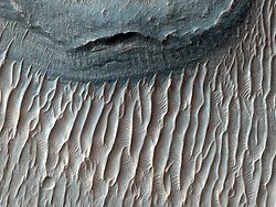
origin only separated in age by crater distribution. Also there is etched massive floor material that is like the younger and older massive material except that it has wind erosional features on it. There are also a few spires of undivided material composed of the same material as the canyon walls.
, which is very similar to Ius and Tithonium chasmata, except geographical location. Also Coprates differs from Ius is the eastern end which contains alluvial deposits and eolian material. Also, Coprates, like Ius, has layered deposits, although the deposits in the Coprates Chasma are much more well defined. These deposits pre-date the Valles Marineris system, suggesting erosion and sedimentary processes later cut by the Valles Marineris system. Newer data from Mars Global Surveyor
suggest that the origin of this layering is either just a succession of landslide
s, one over another, volcanic in origin, or it may be the bottom of a basin of either liquid or solid water ice suggesting that the peripheral canyons of the Valles Marineris system could have been at one time isolated lakes formed from erosional collapse. Another possible source of the layered deposits could be wind-blown, but the diversity of the layers suggests that this material is not dominant. Also noted is that only the upper layers are thin, while the bottom layers are very big, suggesting that the lower layers were composed of mass wasted rock and the upper layers come from another source. Some of this layering may have been transferred to the floor by landslides in which the layers are kept semi-intact yet looks like a highly deformed layered section with thickening and thinning beds that have multitudes of folds in them as seen in MOC image #8405. This complex terrain could also be just eroded sediment from an ancient Martian lake-bed and appear complex because all that we have is an aerial view like a geologic map and not enough elevation data to see if the beds are horizontal.
and Ganges
chasmata. Eos Chasma’s western floor is mainly composed of an etched massive material composed of either volcanic or eolian deposits later eroded by the Martian wind. The eastern end of the Eos chasma has a large area of streamlined bars and longitudinal striations. This is interpreted to be stream-carved plateau deposits and material transported and deposited by flowing fluid. Gangis Chasma is an offshoot chasma of Eos in a general east-west trend. The floor of Gangis is mainly composed of alluvial deposits from the canyon walls.
region of the northern plains of Mars at an elevation only one kilometer above the deepest point of Valles Marineris in Melas Chasma. The outflow regions of the northern plains are similar to the terrain seen at the Mars Pathfinder
landing site. A terrestrial counterpart of these outflow channels
on Earth would be the scablands
of eastern Washington. The eastern Washington scablands are a result of repeated catastrophic flooding due to the build-up of an ice dam at the head of Lake Missoula in the Late Pleistocene
. The ice dam would block the water for a while, but when it broke, the ice would float on top of the ensuing flood and vast areas would be stripped of topsoil and vegetation, leaving a large barren area of 'teardrop' islands, longitudinal grooves and terraced margins. Many of these features are also seen in Martian outflow channels, but on a larger scale.
The outflow occurs successively through several regions of chaotic terrain, Aurorae Chaos and Hydraotes Chaos
, and finally through Simud Valles
and Tiu Valles
into Chryse Planitia.
Mars
Mars is the fourth planet from the Sun in the Solar System. The planet is named after the Roman god of war, Mars. It is often described as the "Red Planet", as the iron oxide prevalent on its surface gives it a reddish appearance...
surface east of the Tharsis
Tharsis
The Tharsis region on Mars is a vast volcanic plateau centered near the equator in Mars’ western hemisphere. The region is home to the largest volcanoes in the Solar System, including the three enormous shield volcanoes Arsia Mons, Pavonis Mons, and Ascraeus Mons, which are collectively known as...
region. At more than 4,000 km long, 200 km wide and up to 7 km deep, the Valles Marineris rift system is one of the larger canyons of the Solar System, surpassed only by the rift valley
Rift valley
A rift valley is a linear-shaped lowland between highlands or mountain ranges created by the action of a geologic rift or fault. This action is manifest as crustal extension, a spreading apart of the surface which is subsequently further deepened by the forces of erosion...
s of Earth and (in length only) by Baltis Vallis
Baltis Vallis
Baltis Vallis is a sinuous channel on Venus ranging from one to three kilometers wide and more than 7,000 kilometers long, slightly longer than the Nile and the longest known channel of any kind in the solar system. It is thought that it once held a river of lava known as a lava channel.The channel...
on Venus.
Valles Marineris is located along the equator of Mars, on the east side of the Tharsis
Tharsis
The Tharsis region on Mars is a vast volcanic plateau centered near the equator in Mars’ western hemisphere. The region is home to the largest volcanoes in the Solar System, including the three enormous shield volcanoes Arsia Mons, Pavonis Mons, and Ascraeus Mons, which are collectively known as...
Bulge, and stretches for nearly a quarter of the planet’s circumference. The Valles Marineris system starts in the west with the Noctis Labyrinthus
Noctis Labyrinthus
Noctis Labyrinthus, "the labyrinth of the night", is a region of Mars between the Valles Marineris and the Tharsis upland. It is located in the Phoenicis Lacus quadrangle. The region is notable for its maze-like system of deep, steep-walled valleys...
; proceeding to the east are Tithonium
Tithonium Chasma
Tithonium Chasma is a large canyon in the Coprates quadrangle of Mars at 4.6° south latitude and 84.7° west longitude. It is about 810 km long and was named after a classical albedo feature name.- Valles Marineris Canyon System :...
and Ius
Ius Chasma
Ius Chasma is a large canyon in the Coprates quadrangle of Mars at 7° south latitude and 85.8° west longitude. It is about 938 km long and was named after a classical albedo feature name.- Valles Marineris Canyon System :...
chasma
Chasma
Chasma is a term used in astrogeology to refer to "a deep, elongated, steep-sided depression". The plural is chasmata. An example is Eos Chasma on Mars. Below are images of some of the major chasmata of Mars...
ta, then Melas
Melas Chasma
Melas Chasma is a canyon on Mars, the widest segment of the Valles Marineris canyon system, located east of Ius Chasma at 9.8°S, 283.6°E. It cuts through layered deposits that are thought to be sediments from an old lake that resulted from runoff of the valley networks to the west. Other theories...
and Ophir
Ophir Chasma
Ophir Chasma is a canyon in the Coprates quadrangle of Mars at 4° south latitude and 72.5° west longitude. It is about 317 km long and was named after the classical albedo feature name.- Valles Marineris Canyon System :...
chasmata, then Coprates Chasma, then Ganges
Ganges Chasma
The Ganges Chasma is a deep canyon at the eastern end of the vast Valles Marineris system on Mars, an offshoot of Eos Chasma. It is named after the River Ganges in South Asia. It has been tentatively identified as an outflow channel....
, Capri and Eos
Eos Chasma
Eos Chasma is a chasma in the southern part of the Valles Marineris canyon system of Mars.Eos Chasma’s western floor is mainly composed of an etched massive material composed of either volcanic or eolian deposits later eroded by the Martian wind. The eastern end of the Eos chasma has a large area...
chasmata; finally it empties into an outflow channel region containing chaotic terrain that ends in the basin of Chryse Planitia
Chryse Planitia
Chryse Planitia is a smooth circular plain in the northern equatorial region of Mars close to the Tharsis region to the west, centered at . Chryse Planitia lies partially in the Lunae Palus quadrangle and partially in the Oxia Palus quadrangle...
. Most researchers agree that Valles Marineris is a large tectonic
Tectonics
Tectonics is a field of study within geology concerned generally with the structures within the lithosphere of the Earth and particularly with the forces and movements that have operated in a region to create these structures.Tectonics is concerned with the orogenies and tectonic development of...
"crack" in the Martian crust that formed as the crust rose in the Tharsis
Tharsis
The Tharsis region on Mars is a vast volcanic plateau centered near the equator in Mars’ western hemisphere. The region is home to the largest volcanoes in the Solar System, including the three enormous shield volcanoes Arsia Mons, Pavonis Mons, and Ascraeus Mons, which are collectively known as...
region to the west, and was subsequently widened by erosional forces. However, near the eastern flanks of the rift there appear to be some channels that may have been formed by water
Water
Water is a chemical substance with the chemical formula H2O. A water molecule contains one oxygen and two hydrogen atoms connected by covalent bonds. Water is a liquid at ambient conditions, but it often co-exists on Earth with its solid state, ice, and gaseous state . Water also exists in a...
or carbon dioxide
Carbon dioxide
Carbon dioxide is a naturally occurring chemical compound composed of two oxygen atoms covalently bonded to a single carbon atom...
.
Formation
Water
Water is a chemical substance with the chemical formula H2O. A water molecule contains one oxygen and two hydrogen atoms connected by covalent bonds. Water is a liquid at ambient conditions, but it often co-exists on Earth with its solid state, ice, and gaseous state . Water also exists in a...
or thermokarst
Thermokarst
Thermokarst is a land surface characterised by very irregular surfaces of marshy hollows and small hummocks formed as ice-rich permafrost thaws, that occurs in Arctic areas, and on a smaller scale in mountainous areas such as the Himalayas and the Swiss Alps...
activity, which is the melting of permafrost
Permafrost
In geology, permafrost, cryotic soil or permafrost soil is soil at or below the freezing point of water for two or more years. Ice is not always present, as may be in the case of nonporous bedrock, but it frequently occurs and it may be in amounts exceeding the potential hydraulic saturation of...
in glacial climes. Thermokarst activity may contribute, but erosion by water is not very likely because liquid water cannot exist in most current Martian surface conditions, which typically experience about 1% earth’s atmospheric pressure and a temperature range of 148 to 310 degrees kelvin
Kelvin
The kelvin is a unit of measurement for temperature. It is one of the seven base units in the International System of Units and is assigned the unit symbol K. The Kelvin scale is an absolute, thermodynamic temperature scale using as its null point absolute zero, the temperature at which all...
. However, scientists agree that there was liquid water
Water on Mars
Water on Mars is a psychedelic rock and electronic music group from Quebec City, Québec, Canada. The music trio is led by Philippe Navarro, guitarist, vocalist, arranger, producer, principal lyricist, and music composer....
flowing on the Martian surface in the past. Valles Marineris may have been formed by flowing water at this time. Another hypothesis by McCauley in 1972 was that the canyons formed by withdrawal of subsurface magma. Around 1989 Tanaka and Golombek proposed a theory of formation by tensional fracturing. The most agreed upon theory today is that Valles Marineris was formed by rift faults like the East African Rift Valley
Great Rift Valley
The Great Rift Valley is a name given in the late 19th century by British explorer John Walter Gregory to the continuous geographic trench, approximately in length, that runs from northern Syria in Southwest Asia to central Mozambique in South East Africa...
, later made bigger by erosion and collapsing of the rift walls.
Because Valles Marineris is thought to be a large rift valley, its formation is closely tied with the formation of the Tharsis
Tharsis
The Tharsis region on Mars is a vast volcanic plateau centered near the equator in Mars’ western hemisphere. The region is home to the largest volcanoes in the Solar System, including the three enormous shield volcanoes Arsia Mons, Pavonis Mons, and Ascraeus Mons, which are collectively known as...
Bulge. The Tharsis Bulge was formed from the Noachian to Late Hesperian period of Mars. Tharsis was formed in three stages, appropriately named one, two and three. Stage one of the Tharsis construction consisted of a combination of volcanism and isostatic uplift; soon, however, the volcanism
Volcano
2. Bedrock3. Conduit 4. Base5. Sill6. Dike7. Layers of ash emitted by the volcano8. Flank| 9. Layers of lava emitted by the volcano10. Throat11. Parasitic cone12. Lava flow13. Vent14. Crater15...
loaded the crust to a point at which the crust could no longer support the added weight of Tharsis, leading to widespread graben
Graben
In geology, a graben is a depressed block of land bordered by parallel faults. Graben is German for ditch. Graben is used for both the singular and plural....
s in the elevated regions of Tharsis. Stage two consisted of more volcanism and a loss of isostatic equilibrium
Isostasy
Isostasy is a term used in geology to refer to the state of gravitational equilibrium between the earth's lithosphere and asthenosphere such that the tectonic plates "float" at an elevation which depends on their thickness and density. This concept is invoked to explain how different topographic...
; the source regions of the volcanism no longer resided underneath Tharsis, creating a very large load. Finally, the crust failed to hold up Tharsis and the radial fractures, like Valles Marineris, formed. Stage three mainly consisted of more volcanism and asteroid impacts. The crust, having already reached its failure point, just stayed in place and the younger volcanoes formed. Tharsis volcanism occurred at a very low viscosity magma
Magma
Magma is a mixture of molten rock, volatiles and solids that is found beneath the surface of the Earth, and is expected to exist on other terrestrial planets. Besides molten rock, magma may also contain suspended crystals and dissolved gas and sometimes also gas bubbles. Magma often collects in...
, forming shield volcanoes similar to the Hawaiian Island chain
Hawaii
Hawaii is the newest of the 50 U.S. states , and is the only U.S. state made up entirely of islands. It is the northernmost island group in Polynesia, occupying most of an archipelago in the central Pacific Ocean, southwest of the continental United States, southeast of Japan, and northeast of...
, but, because there are no active plate tectonics on Mars, the hotspot activity kept loading the same spot over and over, creating some of the largest volcanoes in the solar system, including the biggest: Olympus Mons
Olympus Mons
Olympus Mons is a large volcanic mountain on the planet Mars. At a height of almost , it is one of the tallest mountains in the Solar System, three times as tall as Mount Everest and more than twice the height of Mauna Kea the tallest mountain on Earth. Olympus Mons is the youngest of the large...
.
Regions of Valles Marineris
Noctis Labyrinthus
The Noctis LabyrinthusNoctis Labyrinthus
Noctis Labyrinthus, "the labyrinth of the night", is a region of Mars between the Valles Marineris and the Tharsis upland. It is located in the Phoenicis Lacus quadrangle. The region is notable for its maze-like system of deep, steep-walled valleys...
, on the western edge of the Valles Marineris Rift System, north of the Syria Planum
Syria Planum
Syria Planum is a broad plateau on surface of Mars, forming part of Tharsis region. It is located at the summit of the Tharsis bulge, and was the center of volcanic and tectonic activity in Martian history from the Noachian to the late Hesperian. It has been confirmed that low shield volcanoes...
and east of Pavonis Mons
Pavonis Mons
Pavonis Mons is a large shield volcano located in the Tharsis region of the planet Mars. It is the middle member of a chain of three volcanic mountains that straddle the Martian equator between longitudes 235°E and 259°E. The volcano was discovered by the Mariner 9 spacecraft in 1971 and was...
, is a jumbled terrain composed of huge blocks which are heavily fractured. Also it contains canyons that run in different directions surrounding large blocks of older terrain. Most of the upper parts of the blocks are composed of younger fractured material thought to be of volcanic origin associated with the Tharsis Bulge. The other tops are composed of older fractured material thought also to be volcanic in origin, but differentiated from the younger material by more ruggedness and more impact craters. The sides of the blocks are composed of undivided material thought to be basement rock. The space between the blocks is composed mainly of either rough or smooth floor material. The rough floor material tends to be in the eastern portion of the Noctis Labyrinthus and is thought to be debris from the walls or maybe eolian features covering rough topography and landslides. The smooth floor material is thought to be composed of fluvial material and/or eolian features covering an otherwise rough and jumbled terrain. Terrains such as Noctis Labyrinthus are commonly found at the head of outflow channels, like the one explored by the Pathfinder mission and its Sojourner rover. They are interpreted to be a place of downward block faulting associated with the removal of ground fluid in catastrophic flood sequences. The fluid could be either carbon-dioxide ice and gas or water. Water is the prevailing theory , but Hoffman proposes carbon dioxide gas/liquid as an agent of flooding.
Ius and Tithonium Chasmata
Ius Chasma
Ius Chasma is a large canyon in the Coprates quadrangle of Mars at 7° south latitude and 85.8° west longitude. It is about 938 km long and was named after a classical albedo feature name.- Valles Marineris Canyon System :...
and Tithonium
Tithonium Chasma
Tithonium Chasma is a large canyon in the Coprates quadrangle of Mars at 4.6° south latitude and 84.7° west longitude. It is about 810 km long and was named after a classical albedo feature name.- Valles Marineris Canyon System :...
chasmata are located parallel to each other, Ius to the south and Tithonium to the north. Ius is the wider of the two, leading to Melas Chasma. Ius has a ridge down the center of it by the name of Geryon Montes, composed of the undivided basement rock. The floor of Ius Chasma is mostly composed of slide material that is really just a bunch of pristine landslides covering each other; pristine from a lack of cratering or erosion. The southern wall of Ius, and to a lesser extent the northern wall, has a lot of short valleys stretching off to the south. These valleys have a stubby theater headed leading edge very much like features seen on the Colorado Plateau near the Grand Canyon that appear from groundwater sapping
Groundwater sapping
Groundwater sapping is the geomorphic process in which groundwater exits a bank or hillslope laterally as seeps and springs and erodes soil from the slope. This often causes the slope to be undermined and undergo mass wasting, hence the word sapping....
. Theater headed means that the head of the valley is a well-defined aerial U-shape that curves back under from the groundwater sapping and the valley is propagated by the continued erosion and the collapse of the wall. Tithonium Chasma is very similar to Ius, except it is lacking the sapping features on the south side and contains a small portion of stuff that is similar to the smooth floor features except that it appears to be an ash fall that has been eroded by the wind forming eolian features. Between the two canyons, the surface is composed of younger fractured material of lava flows and faults from crustal extension of the Tharsis Bulge.
Melas, Candor and Ophir Chasmata
The next portion of Valles Marineris to the east are three chasmata, that from south to north are MelasMelas Chasma
Melas Chasma is a canyon on Mars, the widest segment of the Valles Marineris canyon system, located east of Ius Chasma at 9.8°S, 283.6°E. It cuts through layered deposits that are thought to be sediments from an old lake that resulted from runoff of the valley networks to the west. Other theories...
, Candor
Candor Chasma
Candor Chasma is one of the largest canyons in the Valles Marineris canyon system on Mars. The feature is geographically divided into two halves: East and West Candor Chasmas, respectively...
and Ophir
Ophir Chasma
Ophir Chasma is a canyon in the Coprates quadrangle of Mars at 4° south latitude and 72.5° west longitude. It is about 317 km long and was named after the classical albedo feature name.- Valles Marineris Canyon System :...
chasmata. Melas is east of Ius, Candor is east of Tithonium and Ophir appears as an oval that runs into Candor. All three chasmata are connected. The floor of Melas Chasma is about 70% younger massive material that is thought to be volcanic ash whipped up by the wind into eolian features. It also contains rough floor material from the erosion of the canyon walls. Also, in these central chasmata there is a portion of the floor that is higher than the rest of the floor, most likely left by the continued dropping of the other floor material. Around the edges of Melas is also a lot of slide material as seen in Ius and Tithonium chasmata. This is also the deepest part of the Valles Marineris system at eleven kilometers below the surrounding surface; from here the outflow channels are about a 0.03 degree slope upward to the northern plains, which means that if you filled the canyon with fluid, would have a lake with a depth of one kilometer before the fluid would flow out onto the northern plains.
On the floor of the canyon system between Candor and Melas chasmata is a grooved floor material that is interpreted to be alluvial deposits and/or material that has collapsed or contracted by the removal of ice or water. There are also portions of older and younger massive floor material of volcaniclastic
Pyroclastic rock
Pyroclastic rocks or pyroclastics are clastic rocks composed solely or primarily of volcanic materials. Where the volcanic material has been transported and reworked through mechanical action, such as by wind or water, these rocks are termed volcaniclastic...
origin only separated in age by crater distribution. Also there is etched massive floor material that is like the younger and older massive material except that it has wind erosional features on it. There are also a few spires of undivided material composed of the same material as the canyon walls.
Coprates Chasma
Further to the east, the canyon system runs into Coprates ChasmaCorprates Chasma
Coprates Chasma is a huge canyon in the Coprates quadrangle of Mars, located at 13.4° south latitude and 61.4° west longitude. It is 966 km long and was named after a classical albedo feature name....
, which is very similar to Ius and Tithonium chasmata, except geographical location. Also Coprates differs from Ius is the eastern end which contains alluvial deposits and eolian material. Also, Coprates, like Ius, has layered deposits, although the deposits in the Coprates Chasma are much more well defined. These deposits pre-date the Valles Marineris system, suggesting erosion and sedimentary processes later cut by the Valles Marineris system. Newer data from Mars Global Surveyor
Mars Global Surveyor
The Mars Global Surveyor was a US spacecraft developed by NASA's Jet Propulsion Laboratory and launched November 1996. It began the United States's return to Mars after a 10-year absence. It completed its primary mission in January 2001 and was in its third extended mission phase when, on 2...
suggest that the origin of this layering is either just a succession of landslide
Landslide
A landslide or landslip is a geological phenomenon which includes a wide range of ground movement, such as rockfalls, deep failure of slopes and shallow debris flows, which can occur in offshore, coastal and onshore environments...
s, one over another, volcanic in origin, or it may be the bottom of a basin of either liquid or solid water ice suggesting that the peripheral canyons of the Valles Marineris system could have been at one time isolated lakes formed from erosional collapse. Another possible source of the layered deposits could be wind-blown, but the diversity of the layers suggests that this material is not dominant. Also noted is that only the upper layers are thin, while the bottom layers are very big, suggesting that the lower layers were composed of mass wasted rock and the upper layers come from another source. Some of this layering may have been transferred to the floor by landslides in which the layers are kept semi-intact yet looks like a highly deformed layered section with thickening and thinning beds that have multitudes of folds in them as seen in MOC image #8405. This complex terrain could also be just eroded sediment from an ancient Martian lake-bed and appear complex because all that we have is an aerial view like a geologic map and not enough elevation data to see if the beds are horizontal.
Eos and Ganges Chasmata
Further to the east lie EosEos Chasma
Eos Chasma is a chasma in the southern part of the Valles Marineris canyon system of Mars.Eos Chasma’s western floor is mainly composed of an etched massive material composed of either volcanic or eolian deposits later eroded by the Martian wind. The eastern end of the Eos chasma has a large area...
and Ganges
Ganges Chasma
The Ganges Chasma is a deep canyon at the eastern end of the vast Valles Marineris system on Mars, an offshoot of Eos Chasma. It is named after the River Ganges in South Asia. It has been tentatively identified as an outflow channel....
chasmata. Eos Chasma’s western floor is mainly composed of an etched massive material composed of either volcanic or eolian deposits later eroded by the Martian wind. The eastern end of the Eos chasma has a large area of streamlined bars and longitudinal striations. This is interpreted to be stream-carved plateau deposits and material transported and deposited by flowing fluid. Gangis Chasma is an offshoot chasma of Eos in a general east-west trend. The floor of Gangis is mainly composed of alluvial deposits from the canyon walls.
Chryse region
East of Eos and Ganges, Valles Marineris empties out into the ChryseChryse Planitia
Chryse Planitia is a smooth circular plain in the northern equatorial region of Mars close to the Tharsis region to the west, centered at . Chryse Planitia lies partially in the Lunae Palus quadrangle and partially in the Oxia Palus quadrangle...
region of the northern plains of Mars at an elevation only one kilometer above the deepest point of Valles Marineris in Melas Chasma. The outflow regions of the northern plains are similar to the terrain seen at the Mars Pathfinder
Mars Pathfinder
Mars Pathfinder was an American spacecraft that landed a base station with roving probe on Mars in 1997. It consisted of a lander, renamed the Carl Sagan Memorial Station, and a lightweight wheeled robotic rover named Sojourner.Launched on December 4, 1996 by NASA aboard a Delta II booster a...
landing site. A terrestrial counterpart of these outflow channels
Outflow channels
Outflow channels is the term used to describe extremely long, wide swathes of scoured ground on Mars, commonly containing the streamlined remnants of pre-existing topography and other linear erosive features indicating sculpting by fluids moving downslope...
on Earth would be the scablands
Channeled scablands
The Channeled Scablands are a unique geological erosion feature in the U.S. state of Washington. They were created by the cataclysmic Missoula Floods that swept periodically across eastern Washington and down the Columbia River Plateau during the Pleistocene epoch. Geologist J Harlen Bretz coined...
of eastern Washington. The eastern Washington scablands are a result of repeated catastrophic flooding due to the build-up of an ice dam at the head of Lake Missoula in the Late Pleistocene
Late Pleistocene
The Late Pleistocene is a stage of the Pleistocene Epoch. The beginning of the stage is defined by the base of the Eemian interglacial phase before the final glacial episode of the Pleistocene 126,000 ± 5,000 years ago. The end of the stage is defined exactly at 10,000 Carbon-14 years BP...
. The ice dam would block the water for a while, but when it broke, the ice would float on top of the ensuing flood and vast areas would be stripped of topsoil and vegetation, leaving a large barren area of 'teardrop' islands, longitudinal grooves and terraced margins. Many of these features are also seen in Martian outflow channels, but on a larger scale.
The outflow occurs successively through several regions of chaotic terrain, Aurorae Chaos and Hydraotes Chaos
Hydraotes Chaos
Hydraotes Chaos is a broken up region in the Oxia Palus quadrangle of Mars, located at 0.8° North and 35.4° West. It is 417.5 km across and was named after a classical albedo feature name. More information and more examples of Chaos can be found at Chaos terrain....
, and finally through Simud Valles
Simud Valles
Simud Valles is an ancient outflow channel in the Oxia Palus quadrangle of Mars, located at 19.8° N and 37.8° W. It is 945.0 km long and was named for the word for "Mars" in Sumerian. Note: Descriptor term changed to the plural , and coordinates redefined 3/31/2008....
and Tiu Valles
Tiu Valles
Tiu Valles is an outflow channel in the Oxia Palus quadrangle of Mars, located at 15.9° North and 35.7° West.It is 1,720 km long and was named after the word for "Mars" in old English ....
into Chryse Planitia.
External links
- Google Video Fly Through (narrated)
- Google Mars scrollable map - centered on Valles Marineris
- Computer Simulation of a flyby through Mariner Valley on "Maniac World"
- NASA/Arizona State University flythrough
- Flying around Candor Chasma at an altitude of 100 meters