

Groundwater sapping
Encyclopedia
Geomorphology
Geomorphology is the scientific study of landforms and the processes that shape them...
process in which groundwater
Groundwater
Groundwater is water located beneath the ground surface in soil pore spaces and in the fractures of rock formations. A unit of rock or an unconsolidated deposit is called an aquifer when it can yield a usable quantity of water. The depth at which soil pore spaces or fractures and voids in rock...
exits a bank or hillslope laterally as seeps
Seep (hydrology)
A Seep is a moist or wet place where water, usually groundwater, reaches the earth's surface from an underground aquifer.-Description:Seeps are usually not of sufficient volume to be flowing beyond their above-ground location. They are part of the limnology-geomorphology system...
and springs
Spring (hydrosphere)
A spring—also known as a rising or resurgence—is a component of the hydrosphere. Specifically, it is any natural situation where water flows to the surface of the earth from underground...
and erodes
Erosion
Erosion is when materials are removed from the surface and changed into something else. It only works by hydraulic actions and transport of solids in the natural environment, and leads to the deposition of these materials elsewhere...
soil
Soil
Soil is a natural body consisting of layers of mineral constituents of variable thicknesses, which differ from the parent materials in their morphological, physical, chemical, and mineralogical characteristics...
from the slope. This often causes the slope to be undermined and undergo mass wasting
Mass wasting
Mass wasting, also known as slope movement or mass movement, is the geomorphic process by which soil, regolith, and rock move downslope under the force of gravity. Types of mass wasting include creep, slides, flows, topples, and falls, each with its own characteristic features, and taking place...
, hence the word sapping.
This is one of the processes involved in the formation of gullies
Gully
A gully is a landform created by running water, eroding sharply into soil, typically on a hillside. Gullies resemble large ditches or small valleys, but are metres to tens of metres in depth and width...
, such as lavaka
Lavaka
Lavaka, the Malagasy word for "hole",with steep sides usually on the side of a hill is a type of erosional feature common in Madagascar. They are most abundant in the Central Highlands, where there are deep laterites developed on in steep terrain in a monsoonal climate...
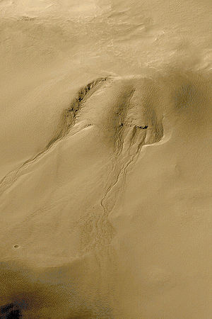
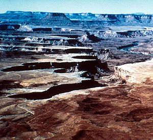
. Erosion by sapping tends to produce steep-sided U-shaped valley
U-shaped valley
A U-shaped valley also known as a glacial trough is one formed by the process of glaciation. It has a characteristic U-shape, with steep, straight sides, and a flat bottom. Glaciated valleys are formed when a glacier travels across and down a slope, carving the valley by the action of scouring...
s of fairly uniform width with box-like, "theater-shaped" headwall
Headwall
In physical geography and geology the headwall of a glacial cirque is its highest cliff.In civil engineering, a headwall is a small retaining wall placed at the outlet of a stormwater pipe or culvert....
s. This contrasts with the more common branching or dentritic pattern of V-shaped valleys produced by overland flows that become wider with distance from their source. Groundwater sapping has been suggested as the cause for erosion of the valley and channel networks on Mars
Valley networks (Mars)
Valley networks are branching networks of valleys on Mars that superficially resemble terrestrial river drainage basins. They are found mainly incised into the terrain of the martian southern highlands, and are typically - though not always - of Noachian age...
, although studies show that groundwater alone can not excavate and transport the material required to create these canyons.
External links
- Simulation of Groundwater Sapping
- Alan D. Howard, "Introduction: Groundwater Sapping on Mars and Earth" in Sapping Features of the Colorado Plateau, edited by A.D. Howard, R. C. Kochel, and H. R. Holt, NASA SP-491, p. 1-5 (1988)
- Julie E. Laity and Michael C. Malin, "Sapping processes and the development of theater-headed valley networks on the Colorado Plateau," Geological Society of America Bulletin: Vol. 96, No. 2 (1985), pp. 203–217 (Abstract).
- T.F. Stepinski and S. Coradetti, "Comparing morphologies of drainage basins on Mars and Earth using integral-geometry and neural maps."