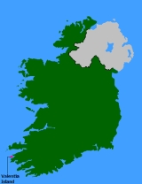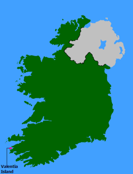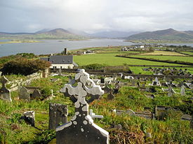
Valentia Island
Encyclopedia

Ireland
Ireland is an island to the northwest of continental Europe. It is the third-largest island in Europe and the twentieth-largest island on Earth...
's westernmost points, lying off the Iveragh Peninsula
Iveragh Peninsula
The Iveragh Peninsula is located in County Kerry in Ireland. It is the largest peninsula in southwestern Ireland. A mountain range, the Macgillycuddy's Reeks, lies in the centre of the peninsula...
in the southwest of County Kerry
County Kerry
Kerry means the "people of Ciar" which was the name of the pre-Gaelic tribe who lived in part of the present county. The legendary founder of the tribe was Ciar, son of Fergus mac Róich. In Old Irish "Ciar" meant black or dark brown, and the word continues in use in modern Irish as an adjective...
, Ireland
Republic of Ireland
Ireland , described as the Republic of Ireland , is a sovereign state in Europe occupying approximately five-sixths of the island of the same name. Its capital is Dublin. Ireland, which had a population of 4.58 million in 2011, is a constitutional republic governed as a parliamentary democracy,...
. It is linked to the mainland by the Maurice O'Neill Memorial bridge at Portmagee
Portmagee
Portmagee is a village in County Kerry, Ireland. The village is located on the west coast of Ireland, on Kerry's Iveragh peninsula south of Valentia Island. The name in Irish means 'the ferry', referring to its purpose as a crossing point to the island...
, as well as by a ferry
Ferry
A ferry is a form of transportation, usually a boat, but sometimes a ship, used to carry primarily passengers, and sometimes vehicles and cargo as well, across a body of water. Most ferries operate on regular, frequent, return services...
which sails from Reenard Point to Knightstown
Knightstown, County Kerry
Knightstown is the largest settlement on Valentia Island, County Kerry, Ireland. It lies within the townland of Farranreagh, at the eastern tip of the island. Knightstown has a population of 172 . In the 1830s the then Knight of Kerry commissioned Scottish Engineer Alexander Nimmo to draw up plans...
, the island
Island
An island or isle is any piece of sub-continental land that is surrounded by water. Very small islands such as emergent land features on atolls can be called islets, cays or keys. An island in a river or lake may be called an eyot , or holm...
's main settlement. The permanent population of the island is 650, and the island is approximately 11 kilometres (6.8 mi) long by almost 3 kilometres (1.9 mi) wide.
History
Valentia was the eastern terminus of the first commercially viable transatlantic telegraph cableTransatlantic telegraph cable
The transatlantic telegraph cable was the first cable used for telegraph communications laid across the floor of the Atlantic Ocean. It crossed from , Foilhommerum Bay, Valentia Island, in western Ireland to Heart's Content in eastern Newfoundland. The transatlantic cable connected North America...
. The first attempt in 1857 to land a cable from Ballycarbery Strand on the mainland just east of Valentia Island ended in disappointment. After subsequent failures of cables landed at Knightstown in 1858 and Foilhommerum Bay in 1865, the vast endeavor finally resulted in commercially viable transatlantic telegraph communications from Foilhommerum Bay to Heart's Content, Newfoundland in 1866. Transatlantic telegraph cables operated from Valentia Island for one hundred years, ending with Western Union International terminating its cable operations in 1966.
Prior to the transatlantic telegraph, American longitude measurements had a 2800 feet (853.4 m) uncertainty with respect to European longitudes. Because of the importance of accurate longitudes to safe navigation, the U.S. Coast Survey
U.S. National Geodetic Survey
National Geodetic Survey, formerly called the U.S. Coast and Geodetic Survey , is a United States federal agency that defines and manages a national coordinate system, providing the foundation for transportation and communication; mapping and charting; and a large number of applications of science...
mounted a longitude expedition in 1866 to link longitudes in the United States accurately to the Royal Observatory in Greenwich
Royal Observatory, Greenwich
The Royal Observatory, Greenwich , in London, England played a major role in the history of astronomy and navigation, and is best known as the location of the prime meridian...
. Benjamin Gould
Benjamin Apthorp Gould
Benjamin Apthorp Gould was a pioneering American astronomer. He is notable for creating the Astronomical Journal, discovering the Gould Belt, and for founding of the Argentine National Observatory and the Argentine National Weather Service.-Biography:He was born in Boston, Massachusetts, son of...
and his partner A. T. Mosman reached Valentia on 2 October 1866. They built a temporary longitude observatory beside the Foilhommerum Cable Station to support synchronized longitude observations with Heart's Content
Heart's Content, Newfoundland and Labrador
Heart's Content is an incorporated town in Trinity Bay on the Bay de Verde Peninsula of Newfoundland and Labrador, Canada. The natural harbour that makes up the town is located on the east side of Trinity Bay and it is built along the northeast side and the southeast base of this...
, Newfoundland. After many rainy and cloudy days, the first transatlantic longitude signals were exchanged between Foilhommerum and Hearts's Content on October 24, 1866.
In 1993, an undergraduate geology student discovered fossilised tetrapod
Tetrapod
Tetrapods are vertebrate animals having four limbs. Amphibians, reptiles, birds and mammals are all tetrapods; even snakes and other limbless reptiles and amphibians are tetrapods by descent. The earliest tetrapods evolved from the lobe-finned fishes in the Devonian...
trackway
Fossil trackway
A fossil trackway is a type of trace fossil, a trackway made by an organism. Many fossil trackways were made by dinosaurs, early tetrapods, and other quadrupeds and bipeds on land...
s (51.930868°N 10.343849°W), footprints in mud preserved in Devonian
Devonian
The Devonian is a geologic period and system of the Paleozoic Era spanning from the end of the Silurian Period, about 416.0 ± 2.8 Mya , to the beginning of the Carboniferous Period, about 359.2 ± 2.5 Mya...
rocks on the north coast of the island. About 385 million years ago, a primitive vertebrate
Vertebrate
Vertebrates are animals that are members of the subphylum Vertebrata . Vertebrates are the largest group of chordates, with currently about 58,000 species described. Vertebrates include the jawless fishes, bony fishes, sharks and rays, amphibians, reptiles, mammals, and birds...
passed along a muddy shoreline in the equatorial swampland that is now southwestern Ireland and left prints as if in wet concrete. The prints were preserved by silt overlying them, and were converted to rock over the ages. The Valentia Island trackways are among the oldest signs of vertebrate life on land and have been studied extensively by the palaeontologist
Paleontology
Paleontology "old, ancient", ὄν, ὀντ- "being, creature", and λόγος "speech, thought") is the study of prehistoric life. It includes the study of fossils to determine organisms' evolution and interactions with each other and their environments...
Dr Stössel.
Places of interest

Tourist destinations in Ireland
-Destinations by county:*Antrim**Antrim Coast and Glens**Ballycastle**Belfast, capital of Northern Ireland, second largest city on the island***Edwardian City Hall***the murals in Falls Road, Sandy Row and Shankill Road**Carrickfergus Castle...
, easily accessible from the popular Ring of Kerry
Ring of Kerry
The Ring of Kerry is a tourist trail in County Kerry, south-western Ireland. The route covers the 179 km circular road , starting from Killarney, heading around the Iveragh Peninsula and passing through Kenmare, Sneem, Waterville, Cahersiveen and Killorglin...
route.
- Geokaun Mountain and Fogher CliffsGeokaun Mountain and Fogher CliffsGeokaun Mountain is the highest mountain on Valentia Island, County Kerry. On its northern face the Fogher Cliffs meet the sea.From the summit there are views of the Skellig Islands, Dingle Peninsula, the Blasket Islands, Beginish Island, Cahersiveen, Portmagee and Macgillycuddy's Reeks, including...
: the highest mountain on Valentia Island and the sea cliffs of 600 feet (182.9 m) on its northern face. - On the northeast of the island stands Glanleam House amid sub-tropical gardens. Protected by windbreakWindbreakA windbreak or shelterbelt is a plantation usually made up of one or more rows of trees or shrubs planted in such a manner as to provide shelter from the wind and to protect soil from erosion. They are commonly planted around the edges of fields on farms. If designed properly, windbreaks around a...
s from Atlantic gales and never touched by frost, these gardens provide the mildest microclimateMicroclimateA microclimate is a local atmospheric zone where the climate differs from the surrounding area. The term may refer to areas as small as a few square feet or as large as many square miles...
in Ireland. Starting in the 1830s, Sir Peter George Fitzgerald, the 19th Knight of KerryKnight of KerryKnight of Kerry, also called the Green Knight, is one of three Anglo-Irish hereditary knighthoods, all of which existed in Ireland since feudal times. The others are the White Knight and the Knight of Glin...
(1808–1880), planted these gardens and stocked them with a unique collection of rare and tender plants from the southern hemisphere, normally grown under glass in IrelandIrelandIreland is an island to the northwest of continental Europe. It is the third-largest island in Europe and the twentieth-largest island on Earth...
. The gardens are laid out in a naturalistic style as a series of walks. There are plants from South America, Australia, New Zealand (the tallest tree ferns in Europe), Chile, and Japan. The gardens are memorialized in a selected golden-variegated Luma apiculataLuma (plant)Luma is a genus of two species of plants in the myrtle family Myrtaceae, native to the Valdivian temperate rain forests of southwestern South America. They are shrubs or small trees with evergreen foliage and smooth red or orange bark, typically reaching 10–20 m tall and up to 1 m trunk diameter...
"Glanleam Gold" that originated as a sport in the garden. The gardens are open to the public. - The recently reopened slate quarry provided slates for the British Houses of ParliamentPalace of WestminsterThe Palace of Westminster, also known as the Houses of Parliament or Westminster Palace, is the meeting place of the two houses of the Parliament of the United Kingdom—the House of Lords and the House of Commons...
. - The island also hosts a heritage centre which tells the story of the geology, human, natural and industrial history of the island, with exhibits on the Cable Station, the Marine Radio Station and the RNLI lifeboatLifeboat (rescue)A rescue lifeboat is a boat rescue craft which is used to attend a vessel in distress, or its survivors, to rescue crewmen and passengers. It can be hand pulled, sail powered or powered by an engine...
. - The Telegraph Field (or Longitude Field) is the site of the first permanent communications link between EuropeEuropeEurope is, by convention, one of the world's seven continents. Comprising the westernmost peninsula of Eurasia, Europe is generally 'divided' from Asia to its east by the watershed divides of the Ural and Caucasus Mountains, the Ural River, the Caspian and Black Seas, and the waterways connecting...
and the United StatesUnited StatesThe United States of America is a federal constitutional republic comprising fifty states and a federal district...
. Transatlantic telegraph cableTransatlantic telegraph cableThe transatlantic telegraph cable was the first cable used for telegraph communications laid across the floor of the Atlantic Ocean. It crossed from , Foilhommerum Bay, Valentia Island, in western Ireland to Heart's Content in eastern Newfoundland. The transatlantic cable connected North America...
s operated from Valentia Island from 1866.
| Dolmen Rock, western slope of Mt Geokaun | Balleyhearney House, Balleyhearney East. 'Famine Era' hospital adjacent to the Knights' Wood. | Rare Snow Day Main Road Valentia Island looking toward Knightstown, Valentia Harbour and Cahirciveen |
| Portion of the view from the summit of Mt Geokaun ("yo-kawn"). Valentia Harbour and Cahirciveen are in the background | Portion of the view from the summit of Mt Geokaun ("yo-kawn"). Valentia Harbour and Letter are in the background | View from Culloo Rock. Dingle Peninsula, Dingle Bay and the north shore of Valentia Island (including Folger Cliffs) are in the background. |
| Vertical view from Culloo Rock |
Weather Station
The Valentia Island Weather Station is located 51° 56' 23"N, 10° 14'40"W and is 11 metres (36 ft) above the mean sea level. Valentia Observatory is part of Met Éireann, the Irish Meteorological Service. The observatory was set up in August 1868. Valentia island is, on average, the wettest weather station in Ireland. The monthly averages for Sunshine and Rainfall are based on 2010 statistics which are around average apart from July, which received only 40% of its normal sunshine hours and 219% of its normal rainfall.Climate
Notable people
- Valentia is the home of former Gaelic footballGaelic footballGaelic football , commonly referred to as "football" or "Gaelic", or "Gah" is a form of football played mainly in Ireland...
er, Mick O'Connell and the birthplace of John J "Scéilig" O'KellyJohn J. O'KellyJohn Joseph O'Kelly was an Irish politician, author and publisher. He was a former president of the Gaelic League and of Sinn Féin. He was born on Valentia Island off the County Kerry coast.-Political career:He joined Sinn Féin at its inaugural meeting on November 5, 1905...
, the early 20th century Sinn FéinSinn FéinSinn Féin is a left wing, Irish republican political party in Ireland. The name is Irish for "ourselves" or "we ourselves", although it is frequently mistranslated as "ourselves alone". Originating in the Sinn Féin organisation founded in 1905 by Arthur Griffith, it took its current form in 1970...
politician. - It is also considered home to Mug RuithMug RuithMug Ruith is a figure in Irish mythology, a powerful blind druid of Munster who lived on Valentia Island, County Kerry. He could grow to enormous size, and his breath caused storms and turned men to stone. He wore a hornless bull-hide and a bird mask, and flew in a machine called the roth rámach,...
, a powerful blind druidDruidA druid was a member of the priestly class in Britain, Ireland, and Gaul, and possibly other parts of Celtic western Europe, during the Iron Age....
in Irish mythologyIrish mythologyThe mythology of pre-Christian Ireland did not entirely survive the conversion to Christianity, but much of it was preserved, shorn of its religious meanings, in medieval Irish literature, which represents the most extensive and best preserved of all the branch and the Historical Cycle. There are...
. - The American solo rock climber Michael ReardonMichael Reardon (climber)Michael Reardon was a professional American Free Solo Climber, filmmaker, motivational speaker and writer. Reardon perished after being swept to sea by a rogue wave, shortly after climbing a sea cliff in County Kerry, Ireland.-General information:...
died on 13 July 2007 at the Fogher cliffs of Valentia Island when he was swept out to sea following a successful climb.
Fishing
Valentia is a popular fishing location, and Valentia waters hold the Irish records for conger eel, red sea breamRed sea bream
Red sea bream is a name given to at least two species of fish of the family Sparidae, Pagrus major and Pagellus bogaraveo. Pagellus bogaraveo is also known as blackspot sea bream....
, Ray's bream and lesser spotted dogfish.
External links
- Valentia Heritage Centre
- Valentia Island
- Travel Information
- The Tetrapod Trackways
- The Laying of the Atlantic Telegraph Cable
- Telegraph Cable History Trail
- Cable History at the Valentia Heritage Centre
- Alan Hall - Sculptor of the First Transatlantic Cable and First message sent to USA 1856 Memorial
- Submarine Telegraphs, Their History, Construction, and Working by Charles Bright
- Linking European and American Longitude
- IEEE History Center: County Kerry Transatlantic Cable Stations, 1866
- The Transatlantic Longitude as Determined by the Coast Survey Expedition of 1866
- Valentia Island Sea Angling
- The Telegraph Field - Valentia Island
- Resources and Links about the Telegraph Field on Valentia Island

