

Utah State Route 143
Encyclopedia
State Route 143 is a state highway
in the U.S. state of Utah
. The entire highway has been designated the Brian Head-Panguitch Lake Scenic Byway as part of the Utah Scenic Byways
program. This road has also been designated as Utah's Patchwork Parkway as part of the Forest Service Byways program.
At just over 51 miles (82.1 km) long, it connects Parowan
to Panguitch
while providing access to Brian Head
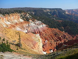
, Cedar Breaks National Monument
, and Panguitch Lake
. It is also the second-highest paved road in the state at 10626 feet (3,238.8 m) above sea level.
The western section of the road from Parowan started as a logging road for nineteenth century Mormon pioneers and was designated a state highway in 1933. Twenty years later, the route was extended to Cedar Breaks National Monument, and again in 1985 to its present-day eastern end in Panguitch.
just west of Parowan
as 200 South and travels through the center of town before turning south into Parowan Canyon. From here, the route climbs past the Vermillion Cliffs, named for their reddish color produced by iron oxide
s. Farther up the canyon, the highway passes by the White Cliffs as it enters Dixie National Forest
, and begins a steep climb up to Brian Head
. With the grade reaching 13% in places, precipitous enough that travel by RV
s or semi trucks is not recommended.
As the route climbs onto the Markagunt Plateau
at an elevation of nearly 10000 feet (3,048 m), it enters the town of Brian Head, Utah's highest incorporated city and the home of Utah's highest ski resort, Brian Head Ski Resort
. From the top of this plateau, vistas open up allowing for views of over 100 miles (160.9 km) in every direction. The area is populated with Engelman spruces, aspen
s, and alpine meadows full of wildflower
s. SR-143 continues climbing southward, passing the northern edge of Cedar Breaks National Monument
, a natural amphitheater canyon
eroded out of the western edge of the plateau similarly to Bryce Canyon. Here, the route reaches its highest point at 10626 feet (3,238.8 m) above sea level, the second-highest paved road in Utah behind the Mirror Lake Highway at 10715 feet (3,265.9 m). The route turns to the east here, while continuing south leads to the rest of Cedar Breaks National Monument and State Route 148
(the Cedar Breaks Scenic Byway).
 As the highway heads east, it descends through thick aspen forests interspersed with ancient lava fields. Distant views to the Escalante Mountains, Sevier Plateau, and the Pink Cliffs
of Paunsaugunt Plateau
are visible to the south and east. On this leg of the route, it passes around the south and east sides of Panguitch Lake
, which is popular for summertime fishing
as well as winter ice fishing
. SR-143 continues its descent, heading northeast alongside Panguitch Creek as it enters Garfield County
and exits Dixie National Forest. The route ends at U.S. Route 89 in the city of Panguitch
, 25 miles (40.2 km) from Bryce Canyon National Park
and just east of the Paunsaugunt Plateau.
used this route as far back as the Fremont culture
(AD 7001300). Evidence of their passage is found along the roadway in the form of rock art. More recently, around the time of European settlement, the area was inhabited by the Southern Paiute people who used much of the Markagunt Plateau
for hunting and gathering.
The town of Parowan
was settled in 1851 by Mormon pioneers, who built a wagon road up Parowan Canyon to access timber for buildings. Eventually, this road extended south to Cedar Breaks. In 1919, S. A. Halterman took the first automobile to Cedar Breaks via Parowan Canyon. With improvements to the road completed by 1921, he was able to take visitors on weekly trips to the area.
to the Dixie National Forest
boundary. The route was extended in 1953 to reach from U.S. Route 91 (former State Route 1) in Parowan (Main Street) to the north boundary of Cedar Breaks National Monument
, increasing its length to over 17 miles (27.4 km).
The construction of Interstate 15
(I-15) in the Parowan area caused the state legislature to twice modify the alignment of SR-143. The first change came in 1968, due to I-15 being constructed to bypass Parowan west of town, rather than following the route of US-91/SR-1 through the center of town. As a result, the state legislature moved SR-1 west onto the interstate alignment while keeping the old alignment in the state highway system. This was accomplished by designating the former southwestern part of SR-1 from I-15 at Summit
to Center street in Parowan as a new highway (SR-38) and extending SR-143 through north Parowan up to I-15, incorporating the northwestern part of the former SR-1 alignment.
In 1975, the construction of I-15 was complete, including a second Parowan interchange that had not been in the original plans. This interchange was located west of Parowan, between the Summit interchange to the southwest, and the Parowan interchange to the north. In response, the legislature rerouted SR-143 to connect to the west interchange. Instead of turning north on Main Street, SR-143 now turned south on Main Street for two blocks (coinciding with SR-38) and turned west to reach the new interchange. The two blocks of Main Street overlapping SR-38 were transferred to SR-143, with the remainder of that route deleted and withdrawn from the state highway system. The former route of SR-143 northerly through Parowan was re-designated SR-274.
 The other end of SR-143 has undergone route changes as well. Prior to 1969, SR-55 connected SR-14 with the southern boundary of Cedar Breaks National Monument. That year, as part of a major realignment
of state highways, SR-55 was deleted and its road was designated as part of SR-143. This left SR-143 as a non-contiguous highway, as the portion going through the national monument was not part of the highway designation.
In 1985, the southern portion of SR-143 between SR-14 and the southern Cedar Breaks National Monument boundary was re-designated SR-148, and Panguitch Lake
Road from the eastern monument boundary to US-89 in Panguitch
was added to SR-143. In this same legislative resolution, there was a provision that the portion of the route alignments inside the boundaries of the national monument would be included as part of the state highway system once the Utah Department of Transportation
was granted a right-of-way easement from federal authorities. In 1994, the legislative description of SR-143 was updated to reflect that this easement had been granted. Interestingly, SR-148 still ends at the south boundary of the national monument.
The route was designated as a Utah Scenic Byway called Brian Head-Panguitch Lake Scenic Byway in 1989, and as a Forest Service Byway called Utah's Patchwork Parkway in 2000. It is also currently being considered for nomination as a federal All-American Road.
State highway
State highway, state road or state route can refer to one of three related concepts, two of them related to a state or provincial government in a country that is divided into states or provinces :#A...
in the U.S. state of Utah
Utah
Utah is a state in the Western United States. It was the 45th state to join the Union, on January 4, 1896. Approximately 80% of Utah's 2,763,885 people live along the Wasatch Front, centering on Salt Lake City. This leaves vast expanses of the state nearly uninhabited, making the population the...
. The entire highway has been designated the Brian Head-Panguitch Lake Scenic Byway as part of the Utah Scenic Byways
Utah Scenic Byways
The legislature in the U.S. state of Utah has designated a system of Utah Scenic Byways in addition to the National Scenic Byways that are defined within the state. Some of the state designated routes overlap with the federal designations...
program. This road has also been designated as Utah's Patchwork Parkway as part of the Forest Service Byways program.
At just over 51 miles (82.1 km) long, it connects Parowan
Parowan, Utah
Parowan is a city in and the county seat of Iron County, Utah, United States. The population was 2,790 at the 2010 census.Parowan became the first incorporated city in Iron County in 1851. A fort that had been constructed on the east side of Center Creek the previous year was an initial in the...
to Panguitch
Panguitch, Utah
Panguitch is a city in and the county seat of Garfield County, Utah, United States. The population was 1,623 at the 2000 census.-Geography:Panguitch is located at ....
while providing access to Brian Head
Brian Head, Utah
Brian Head is a town in Iron County, Utah, United States. The population was 118 at the 2000 census, a small increase over the 1990 figure of 109.Brian Head is also the location of the Brian Head Ski Resort.- History :...
, Cedar Breaks National Monument
Cedar Breaks National Monument
Cedar Breaks National Monument is a U.S. National Monument located in the U.S. state of Utah near Cedar City. Cedar Breaks is a natural amphitheater canyon, stretching across , with a depth of over . The elevation of the rim of the canyon is over above sea level.The eroded rock of the canyon is...
, and Panguitch Lake
Panguitch Lake
Panguitch Lake was originally a large natural lake that has now been expanded by the creation of a dam to become a reservoir with a maximum surface area of . The lake, which drains into the Sevier River is located on the Markagunt Plateau, between Panguitch, Utah and Cedar Breaks National Monument...
. It is also the second-highest paved road in the state at 10626 feet (3,238.8 m) above sea level.
The western section of the road from Parowan started as a logging road for nineteenth century Mormon pioneers and was designated a state highway in 1933. Twenty years later, the route was extended to Cedar Breaks National Monument, and again in 1985 to its present-day eastern end in Panguitch.
Route description
State Route 143 begins at Interstate 15 in Iron CountyIron County, Utah
As of the census of 2000, there were 33,779 people, 10,627 households, and 8,076 families residing in the county. The population density was 10 people per square mile . There were 13,618 housing units at an average density of 4 per square mile...
just west of Parowan
Parowan, Utah
Parowan is a city in and the county seat of Iron County, Utah, United States. The population was 2,790 at the 2010 census.Parowan became the first incorporated city in Iron County in 1851. A fort that had been constructed on the east side of Center Creek the previous year was an initial in the...
as 200 South and travels through the center of town before turning south into Parowan Canyon. From here, the route climbs past the Vermillion Cliffs, named for their reddish color produced by iron oxide
Iron oxide
Iron oxides are chemical compounds composed of iron and oxygen. All together, there are sixteen known iron oxides and oxyhydroxides.Iron oxides and oxide-hydroxides are widespread in nature, play an important role in many geological and biological processes, and are widely utilized by humans, e.g.,...
s. Farther up the canyon, the highway passes by the White Cliffs as it enters Dixie National Forest
Dixie National Forest
Dixie National Forest is a United States National Forest in Utah with headquarters in Cedar City. It occupies almost two million acres and stretches for about 170 miles across southern Utah. The largest national forest in Utah, it straddles the divide between the Great Basin and the Colorado River...
, and begins a steep climb up to Brian Head
Brian Head, Utah
Brian Head is a town in Iron County, Utah, United States. The population was 118 at the 2000 census, a small increase over the 1990 figure of 109.Brian Head is also the location of the Brian Head Ski Resort.- History :...
. With the grade reaching 13% in places, precipitous enough that travel by RV
Recreational vehicle
Recreational vehicle or RV is, in North America, the usual term for a Motor vehicle or trailer equipped with living space and amenities found in a home.-Features:...
s or semi trucks is not recommended.
As the route climbs onto the Markagunt Plateau
Markagunt Plateau
The Markagunt Plateau is an plateau located in southwestern Utah between Interstate 15 and U.S. Route 89. It is one of the plateaus that make up the High Plateaus Section of the Colorado Plateau. The plateau encompasses Cedar Breaks National Monument and is part of Cedar Mountain District of...
at an elevation of nearly 10000 feet (3,048 m), it enters the town of Brian Head, Utah's highest incorporated city and the home of Utah's highest ski resort, Brian Head Ski Resort
Brian Head Ski Resort
Brian Head Ski Resort, officially called just "Brian Head Resort", is a ski area located at the town of Brian Head, Utah in the southern Wasatch Range at the base of Parowan, Utah, United States. Opened in 1965, it is Utah's highest ski resort...
. From the top of this plateau, vistas open up allowing for views of over 100 miles (160.9 km) in every direction. The area is populated with Engelman spruces, aspen
Aspen
Populus section Populus, of the Populus genus, includes the aspen trees and the white poplar Populus alba. The five typical aspens are all native to cold regions with cool summers, in the north of the Northern Hemisphere, extending south at high altitudes in the mountains. The White Poplar, by...
s, and alpine meadows full of wildflower
Wildflower
A wildflower is a flower that grows wild, meaning it was not intentionally seeded or planted. Yet "wildflower" meadows of a few mixed species are sold in seed packets. The term "wildflower" has been made vague by commercial seedsmen who are interested in selling more flowers or seeds more...
s. SR-143 continues climbing southward, passing the northern edge of Cedar Breaks National Monument
Cedar Breaks National Monument
Cedar Breaks National Monument is a U.S. National Monument located in the U.S. state of Utah near Cedar City. Cedar Breaks is a natural amphitheater canyon, stretching across , with a depth of over . The elevation of the rim of the canyon is over above sea level.The eroded rock of the canyon is...
, a natural amphitheater canyon
Canyon
A canyon or gorge is a deep ravine between cliffs often carved from the landscape by a river. Rivers have a natural tendency to reach a baseline elevation, which is the same elevation as the body of water it will eventually drain into. This forms a canyon. Most canyons were formed by a process of...
eroded out of the western edge of the plateau similarly to Bryce Canyon. Here, the route reaches its highest point at 10626 feet (3,238.8 m) above sea level, the second-highest paved road in Utah behind the Mirror Lake Highway at 10715 feet (3,265.9 m). The route turns to the east here, while continuing south leads to the rest of Cedar Breaks National Monument and State Route 148
Utah State Route 148
State Route 148 is a state highway in the U.S. state of Utah. The entire highway has been designated the Cedar Breaks Scenic Byway as part of the Utah Scenic Byways and Forest Service Byways programs.-Route description:...
(the Cedar Breaks Scenic Byway).
Pink Cliffs
The Pink Cliffs are a series of highly-dissected cliffs, approximately 35 mi long, along the southeast edge of the Paunsaugunt Plateau in southwestern Utah in the United States...
of Paunsaugunt Plateau
Paunsaugunt Plateau
The Paunsaugunt Plateau is a dissected plateau, rising to an elevation of , in southwestern Utah in the United States. Located in northern Kane County and southwestern Garfield County, it is approximately wide, and extends southward from the Sevier Plateau approximately , terminating in the Pink...
are visible to the south and east. On this leg of the route, it passes around the south and east sides of Panguitch Lake
Panguitch Lake
Panguitch Lake was originally a large natural lake that has now been expanded by the creation of a dam to become a reservoir with a maximum surface area of . The lake, which drains into the Sevier River is located on the Markagunt Plateau, between Panguitch, Utah and Cedar Breaks National Monument...
, which is popular for summertime fishing
Fishing
Fishing is the activity of trying to catch wild fish. Fish are normally caught in the wild. Techniques for catching fish include hand gathering, spearing, netting, angling and trapping....
as well as winter ice fishing
Ice fishing
Ice fishing is the practice of catching fish with lines and fish hooks or spears through an opening in the ice on a frozen body of water. Ice anglers may sit on the stool in the open on a frozen lake, or in a heated cabin on the ice, some with bunks and amenities.-Locations:It is a popular pastime...
. SR-143 continues its descent, heading northeast alongside Panguitch Creek as it enters Garfield County
Garfield County, Utah
Garfield County is a county located in the U.S. state of Utah. As of 2000 the population was 4,735. It was named for James A. Garfield, President of the United States in 1881. Its county seat and largest city is Panguitch.-Geography:...
and exits Dixie National Forest. The route ends at U.S. Route 89 in the city of Panguitch
Panguitch, Utah
Panguitch is a city in and the county seat of Garfield County, Utah, United States. The population was 1,623 at the 2000 census.-Geography:Panguitch is located at ....
, 25 miles (40.2 km) from Bryce Canyon National Park
Bryce Canyon National Park
Bryce Canyon National Park is a national park located in southwestern Utah in the United States. The major feature of the park is Bryce Canyon which, despite its name, is not a canyon but a giant natural amphitheater created by erosion along the eastern side of the Paunsaugunt Plateau...
and just east of the Paunsaugunt Plateau.
Early roads
Archaic hunter-gatherersGreat Basin tribes
The Indigenous peoples of the Great Basin are the Native American peoples of the Great Basin inhabited a cultural region between the Rocky Mountains and the Sierra Nevada, in what is now Nevada, and parts of Oregon, California, Idaho, Wyoming, and Utah. There is very little precipitation in the...
used this route as far back as the Fremont culture
Fremont culture
The Fremont culture or Fremont people is a pre-Columbian archaeological culture which received its name from the Fremont River in the U.S. state of Utah where the first Fremont sites were discovered. The Fremont River itself is named for John Charles Frémont, an American explorer. It inhabited...
(AD 7001300). Evidence of their passage is found along the roadway in the form of rock art. More recently, around the time of European settlement, the area was inhabited by the Southern Paiute people who used much of the Markagunt Plateau
Markagunt Plateau
The Markagunt Plateau is an plateau located in southwestern Utah between Interstate 15 and U.S. Route 89. It is one of the plateaus that make up the High Plateaus Section of the Colorado Plateau. The plateau encompasses Cedar Breaks National Monument and is part of Cedar Mountain District of...
for hunting and gathering.
The town of Parowan
Parowan, Utah
Parowan is a city in and the county seat of Iron County, Utah, United States. The population was 2,790 at the 2010 census.Parowan became the first incorporated city in Iron County in 1851. A fort that had been constructed on the east side of Center Creek the previous year was an initial in the...
was settled in 1851 by Mormon pioneers, who built a wagon road up Parowan Canyon to access timber for buildings. Eventually, this road extended south to Cedar Breaks. In 1919, S. A. Halterman took the first automobile to Cedar Breaks via Parowan Canyon. With improvements to the road completed by 1921, he was able to take visitors on weekly trips to the area.
Parowan to Cedar Breaks
State Route 143 was first commissioned in 1933 as the road from ParowanParowan, Utah
Parowan is a city in and the county seat of Iron County, Utah, United States. The population was 2,790 at the 2010 census.Parowan became the first incorporated city in Iron County in 1851. A fort that had been constructed on the east side of Center Creek the previous year was an initial in the...
to the Dixie National Forest
Dixie National Forest
Dixie National Forest is a United States National Forest in Utah with headquarters in Cedar City. It occupies almost two million acres and stretches for about 170 miles across southern Utah. The largest national forest in Utah, it straddles the divide between the Great Basin and the Colorado River...
boundary. The route was extended in 1953 to reach from U.S. Route 91 (former State Route 1) in Parowan (Main Street) to the north boundary of Cedar Breaks National Monument
Cedar Breaks National Monument
Cedar Breaks National Monument is a U.S. National Monument located in the U.S. state of Utah near Cedar City. Cedar Breaks is a natural amphitheater canyon, stretching across , with a depth of over . The elevation of the rim of the canyon is over above sea level.The eroded rock of the canyon is...
, increasing its length to over 17 miles (27.4 km).
The construction of Interstate 15
Interstate 15 in Utah
In the U.S. state of Utah, Interstate 15 runs north–south through the southwestern and central portions of the state, passing through many of the population centers of that state, including St. George, Provo, Salt Lake City, and Ogden, the latter three being part of the urban area known as...
(I-15) in the Parowan area caused the state legislature to twice modify the alignment of SR-143. The first change came in 1968, due to I-15 being constructed to bypass Parowan west of town, rather than following the route of US-91/SR-1 through the center of town. As a result, the state legislature moved SR-1 west onto the interstate alignment while keeping the old alignment in the state highway system. This was accomplished by designating the former southwestern part of SR-1 from I-15 at Summit
Summit, Utah
Summit is a census-designated place in Iron County, Utah, United States. The population was 160 at the 2010 census.-Demographics:As of the census of 2010, there were 160 people residing in the CDP. There were 79 housing units. The racial makeup of the town was 92.5% White, 3.1% American Indian and...
to Center street in Parowan as a new highway (SR-38) and extending SR-143 through north Parowan up to I-15, incorporating the northwestern part of the former SR-1 alignment.
In 1975, the construction of I-15 was complete, including a second Parowan interchange that had not been in the original plans. This interchange was located west of Parowan, between the Summit interchange to the southwest, and the Parowan interchange to the north. In response, the legislature rerouted SR-143 to connect to the west interchange. Instead of turning north on Main Street, SR-143 now turned south on Main Street for two blocks (coinciding with SR-38) and turned west to reach the new interchange. The two blocks of Main Street overlapping SR-38 were transferred to SR-143, with the remainder of that route deleted and withdrawn from the state highway system. The former route of SR-143 northerly through Parowan was re-designated SR-274.
Cedar Breaks to Panguitch
State highways deleted by the Utah State Legislature in 1969
A number of minor state highways in the U.S. state of Utah were deleted by the State Legislature in 1969.-State Route 50:State Route 50 was originally a branch of SR-122, but was split off as its own route in 1935, running from Wattis southeast to SR-122 east of Hiawatha...
of state highways, SR-55 was deleted and its road was designated as part of SR-143. This left SR-143 as a non-contiguous highway, as the portion going through the national monument was not part of the highway designation.
In 1985, the southern portion of SR-143 between SR-14 and the southern Cedar Breaks National Monument boundary was re-designated SR-148, and Panguitch Lake
Panguitch Lake
Panguitch Lake was originally a large natural lake that has now been expanded by the creation of a dam to become a reservoir with a maximum surface area of . The lake, which drains into the Sevier River is located on the Markagunt Plateau, between Panguitch, Utah and Cedar Breaks National Monument...
Road from the eastern monument boundary to US-89 in Panguitch
Panguitch, Utah
Panguitch is a city in and the county seat of Garfield County, Utah, United States. The population was 1,623 at the 2000 census.-Geography:Panguitch is located at ....
was added to SR-143. In this same legislative resolution, there was a provision that the portion of the route alignments inside the boundaries of the national monument would be included as part of the state highway system once the Utah Department of Transportation
Utah Department of Transportation
The Utah Department of Transportation is an agency of the state government for the U.S. state of Utah. The agency is usually referred to by its initials UDOT . UDOT is charged with maintaining the network of state highways in Utah. The agency is headquartered in the Calvin L. Rampton state office...
was granted a right-of-way easement from federal authorities. In 1994, the legislative description of SR-143 was updated to reflect that this easement had been granted. Interestingly, SR-148 still ends at the south boundary of the national monument.
The route was designated as a Utah Scenic Byway called Brian Head-Panguitch Lake Scenic Byway in 1989, and as a Forest Service Byway called Utah's Patchwork Parkway in 2000. It is also currently being considered for nomination as a federal All-American Road.