
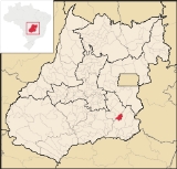
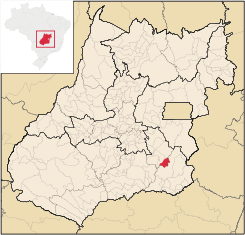
Urutaí
Encyclopedia
| Urutaí | |
|---|---|
| State | Goiás Goiás Goiás is a state of Brazil, located in the central part of the country. The name Goiás comes from the name of an indigenous community... |
| Coordinates: | 17°28′06"S 48°11′42"W |
| Area: | 626.7 km² |
| Population: | 2,727 (IBGE 2007) |
| Elevation: | 807 m |
| Postcode (CEP): | 75790-000 |
| IBGE statistical microregion: | 016 Pires do Rio Microregion Pires do Rio Microregion The Pires do Rio Microregion is a statistical region of south-central Goiás state, Brazil. The most important city is Pires do Rio. The area includes 10 cities with a population of 90,327 in an area of 9,449.80 km²... |
| Became a city: | 1947 |
| Distance to Goiânia Goiânia -Climate:The city has a tropical wet and dry climate with an average temperature of . There's a wet season, from October to April, and a dry one, from May to September. Annual rainfall is around 1,520 mm.... : |
163 km. |
| Website: | none |
Town
A town is a human settlement larger than a village but smaller than a city. The size a settlement must be in order to be called a "town" varies considerably in different parts of the world, so that, for example, many American "small towns" seem to British people to be no more than villages, while...
and municipality
Municipality
A municipality is essentially an urban administrative division having corporate status and usually powers of self-government. It can also be used to mean the governing body of a municipality. A municipality is a general-purpose administrative subdivision, as opposed to a special-purpose district...
in southeast Goiás
Goiás
Goiás is a state of Brazil, located in the central part of the country. The name Goiás comes from the name of an indigenous community...
state, Brazil
Brazil
Brazil , officially the Federative Republic of Brazil , is the largest country in South America. It is the world's fifth largest country, both by geographical area and by population with over 192 million people...
. It is a major producer of poultry products.
Location
Urutaí is located 163 kilometers from the state capital, Goiânia. Highway connections are made by BR-352 / Bela Vista de GoiásBela Vista de Goiás
Bela Vista de Goiás is a small city located in central Goiás state in Brazil.-Location:It is 45 kilometers from the state capital of Goiânia...
/ Cristianópolis
Cristianópolis
This article is about Cristianópolis, Goiás. For Cristianópolis, Mato Grosso see Cristianópolis, Mato GrossoCristianópolis is a small town and municipality in south-eastern Goiás state, Brazil.-Geographical Information:...
/ BR-352 / G-020 / Santa Cruz de Goiás
Santa Cruz de Goiás
Santa Cruz de Goiás is a small town and municipality in southeast Goiás state, Brazil.-Geography:Santa Cruz is located in the southeastern part of the state, 33 km. west of regional center, Pires do Rio...
/ Palmelo
Palmelo
Palmelo is a small town in southeast Goiás state, Brazil. It is the smallest municipality in the state and the only town in Brazil where most of the inhabitants follow the religion called Spiritism.-Location:...
. See Sepin for all the distances.
In the north it borders Pires do Rio
Pires do Rio
Pires do Rio is a small city and municipality in Goiás state, Brazil. It is a prosperous town and a major producer of poultry.-Location:It is located in the Pires do Rio Microregion. . It is located 144 kilometers from the state capital and is served by highways GO-020, 330 and 414, as well as...
and Orizona
Orizona
Orizona is a small town and municipality in Goiás state, Brazil.-Location:Orizona is 138 km from the state capital of Goiânia, 200 km from Brasília, 150 from Catalão and 260 from Uberlândia, which is located in the rich Triângulo Mineiro of Minas Gerais. It is part of the Pires do Rio...
; in the south and the east it borders Ipameri
Ipameri
Ipameri is a small city and municipality in southeastern Goiás state, in Brazil. The population was 23,114 in a total area of 4,368.6 km² . It is a major producer of soybeans, corn, and livestock.-Location and connections:...
; and in the east it borders Pires do Rio
Pires do Rio
Pires do Rio is a small city and municipality in Goiás state, Brazil. It is a prosperous town and a major producer of poultry.-Location:It is located in the Pires do Rio Microregion. . It is located 144 kilometers from the state capital and is served by highways GO-020, 330 and 414, as well as...
.
The elevation is between 654 and 988 meters with the municipal seat lying at 807 meters.
Political information
- Mayor: Ésio Bento Lemos do Prado (January 2005)
- City council: 09 members
- Eligible voters: 2,535 (December/2007)
Demographics
- Population density: 4.35 inhab/km² (2007)
- Population in 1980: 3,138
- Population in 2007: 2,727
- Urban population: 2,212 (2007)
- Rural population: 515 (2007)
- Population growth rate: -0.46% 1996/2007
The economy
The economy is based on subsistence agriculture, cattle raising, services, public administration, and small transformation industries.- Industrial units: 2 (2007)
- Commercial units: 29 (2007)
- Financial institutions: - Banco Itaú S.A.
- Cattle herd: 49,200 head (9,000 milk cows) (2006)
- Poultry: 2,000,000 head (2006)
- Main crops: pineapple, rice, bananas, coffee, sugarcane, beans, manioc, corn, and soybeans.
Agricultural data 2006
- Number of farms: 363
- Total area: 38,412 ha.
- Area of permanent crops: 158 ha.
- Area of perennial crops: 2,055 ha.
- Area of natural pasture: 26,830 ha.
- Area of woodland and forests: 8,363 ha.
- Persons dependent on farming: 760
- Farms with tractors: 52
- Number of tractors: 81
- Cattle herd: 49,200 head IBGE
Education (2006)
- Schools: 4
- Classrooms: 65
- Teachers: 86
- Students: 1,559
- Higher education: Centro Federal de Educação Tecnológica de Urutaí-CEFET-Urutaí
- Adult literacy rate: 88.3% (2000) (national average was 86.4%)
Health (2007)
- Hospitals: 0
- Hospital beds: 0
- Ambulatory clinics: 1
- Infant mortality rate: 24.45 (2000) (national average was 33.0).
History
Urutaí is a town that appeared with the coming of the railroad in 1914. At first houses were built around the railroad station to house workers and soon this settlement grew. In 1947 the town separated from IpameriIpameri
Ipameri is a small city and municipality in southeastern Goiás state, in Brazil. The population was 23,114 in a total area of 4,368.6 km² . It is a major producer of soybeans, corn, and livestock.-Location and connections:...
to become a municipality.
Municipal Human Development Index
Human Development Index
The Human Development Index is a composite statistic used to rank countries by level of "human development" and separate "very high human development", "high human development", "medium human development", and "low human development" countries...
- MHDI: 0.760
- State ranking: 54 (out of 242 municipalities in 2000)
- National ranking: 1,590 (out of 5,507 municipalities in 2000) For a complete list see Frigoletto.com
See also
- List of municipalities in Goiás
- Microregions of Goiás