

Upper Heyford, Oxfordshire
Encyclopedia
Upper Heyford is a village and civil parish about 6 miles (10 km) northwest of Bicester
in Oxfordshire
, England.
. "Upper" distinguishes it from Lower Heyford
which is about 1 miles (1.6 km) "lower", downstream along the Cherwell valley. Upper Heyford has access to the Oxford Canal
from Allens Lane (at Allens Lock) which runs parallel to the River Cherwell. The canal flows from Banbury
and Somerton
to the north towards Lower Heyford and Oxford
to the south.
road running parallel with the River Cherwell
on high ground about 1 miles (1.6 km) east of the river. Its course bisects Upper Heyford parish and passes just east of the village. Part of it forms a minor road to Kirtlington
.
of 1086 records the village as Haiford, with a manor
or 10 hides
that was one of the many estates of the Norman baron Robert D'Oyly
. Along with many manors of the D'Oyly estate, Heyford became part of the Honour of Wallingford
. The manor was tenanted by the de Chesney family until the late 12th century, when Maud de Chesney became married to Henry FitzGerold
, chamberlain to Henry II
. Maud left the manor to her eldest son Warin, who had succeeded to the manor by 1198 and after whom the village became called Heyford Warren. Warin's daughter Margaret married Baldwin de Redvers, son of William de Redvers, 5th Earl of Devon
. Heyford Warren remained with the Earls of Devon and thereby passed to Isabella de Fortibus, Countess of Devon in 1262.
Isabella outlived all her children, so after her death in 1293 her inheritance was disputed between Warin de Lisle and Hugh de Courtenay
, who later became 9th Earl of Devon
. Warin died in 1296 but his son Robert eventually won seisin
of Heyford Warren in 1310, except for two and a half virgate
s that were awarded to de Courtenay. Robert also received the nearby manor of Fritwell from the Countess's estate. In 1380 his great-grandson, also Robert de Lisle, sold the manor along with some land at Barford St. Michael for £1,000 to William of Wykeham
, Bishop of Winchester
, who made them part of his endowment for the foundation of New College, Oxford
.
In about 1400 or shortly thereafter New College had a tithe barn
built at Manor Farm in the village. Its plan is 120 feet (36.6 m) by 24 feet (7.3 m), it is of nine bays
and built of coursed
rubble
with ashlar
quoins
and buttress
es. The roof is of Stonesfield slate and has raised-cruck
truss
es. The building has similarities with tithe barns at Swalcliffe
and Adderbury
, both of which were also built for New College early in the 15th century. It is a scheduled monument and a Grade I listed building.
Upper Heyford's common land
s were enclosed
in 1842. New College still held the manor in the early 1950s.
of Saint Mary
may have been rebuilt in the latter part of the 15th century, but only the Perpendicular Gothic tower
survives from that time. Major repairs to the roof and south aisle were made in 1668 and 1769, but by the 1860s the nave and chancel were in a poor condition again. The architect Thomas Talbot Bury
, a pupil of A.W.N. Pugin, demolished all except the tower in 1865, and rebuilt them in a Gothic Revival
interpretation of Perpendicular Gothic. This Victorian building has extremely regular coursed
masonry, which departs conspicuously from the traditional Medieval rubble masonry
of the tower and, presumably, the previous church building. Bury preserved only a handful of features from the Medieval church: a Perpendicular Gothic window in the north wall of the chancel
, a piscina
, a tomb recess and a 13th century effigy of a priest.
The tower has three bells, the oldest of which is the tenor bell cast in 1624 by Richard I Purdue, who had foundries in places including Glastonbury
and Stoford in Somerset
. Mears & Stainbank of the Whitechapel Bell Foundry
cast the second bell in 1866 and the treble bell in 1946. St. Mary's has also a Sanctus bell of unknown date.
St. Mary's parsonage was designed by William Wilkinson and built in 1869.
St. Mary's is now part of the Cherwell Valley Benefice along with five other parishes: Ardley
, Fritwell
, Lower Heyford
, Somerton
and Souldern
.
 The village comprises just over 100 homes: a mixture of original 18th- and 19th-century Cotswold stone
cottages, converted barns, stone-brick houses, 1950s and 1960s brick bungalows and rendered houses. The most recent houses have Cotswold stone exteriors which is more in keeping with the village's character.
The village green is overlooked by the former school, now a private house. The village has allotments, a sports field (home of Heyford United football team), village hall, children's playground and a public house
: The Barley Mow. The village has a beer festival each August.
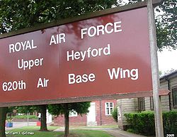
About 1 miles (1.6 km) east of the village is the former RAF Upper Heyford
air base. The RAF
used the air base from the 1920s as a bomber base, then in the 1950s assigned to the USAF
. Since its closure in 1994, the air base has become a substantial industrial and commercial estate. The runway (once the second longest in Europe) is used to store new cars awaiting delivery to dealers. Numerous Cold War
relics remain including disused bunkers, water towers, huts and fences. There is a large number of former MoD houses immediately south of the base and industrial area which are rented.
There is a suggestion that Upper Heyford may be renamed "Heyford Warren" (the name for the village from about 200 years ago) with the Upper Heyford name being retained for the housing at the RAF base. The base has been subject to much speculation regarding development for new housing. Several proposals (firstly for as many as 10,000 homes, then 1,000, then "several hundred") have been rejected. A further planning discussion is underway.
A planning application for RAF Upper Heyford was underway in 2007. The plan proposed the protection of most of the historic elements of the airbase. However, most if not all of the bungalows south of the airfield would be demolished to make way for about 1,000 new houses.
In 2010 it was proposed that Houses south of Camp Road were to be retained and renovated and a new primary school built as well as new homes with some for social housing.
Bicester
Bicester is a town and civil parish in the Cherwell district of northeastern Oxfordshire in England.This historic market centre is one of the fastest growing towns in Oxfordshire Development has been favoured by its proximity to junction 9 of the M40 motorway linking it to London, Birmingham and...
in Oxfordshire
Oxfordshire
Oxfordshire is a county in the South East region of England, bordering on Warwickshire and Northamptonshire , Buckinghamshire , Berkshire , Wiltshire and Gloucestershire ....
, England.
Location
Upper Heyford is on the east bank of the River CherwellRiver Cherwell
The River Cherwell is a river which flows through the Midlands of England. It is a major tributary of the River Thames.The general course of the River Cherwell is north to south and the 'straight-line' distance from its source to the Thames is about...
. "Upper" distinguishes it from Lower Heyford
Lower Heyford
Lower Heyford is a village and civil parish in Oxfordshire, beside the River Cherwell about west of Bicester.-Prehistory:Aves ditch is pre-Anglo-Saxon and may have been dug as a boundary ditch...
which is about 1 miles (1.6 km) "lower", downstream along the Cherwell valley. Upper Heyford has access to the Oxford Canal
Oxford Canal
The Oxford Canal is a narrow canal in central England linking Oxford with Coventry via Banbury and Rugby. It connects with the River Thames at Oxford, to the Grand Union Canal at the villages of Braunston and Napton-on-the-Hill, and to the Coventry Canal at Hawkesbury Junction in Bedworth just...
from Allens Lane (at Allens Lock) which runs parallel to the River Cherwell. The canal flows from Banbury
Banbury
Banbury is a market town and civil parish on the River Cherwell in the Cherwell District of Oxfordshire. It is northwest of London, southeast of Birmingham, south of Coventry and north northwest of the county town of Oxford...
and Somerton
Somerton
Somerton is a small town and civil parish in the South Somerset district of the English county of Somerset. It gave its name to the county of Somerset, was briefly, around the start of the 14th century, the county town, and around 900 AD was possibly the capital of Wessex...
to the north towards Lower Heyford and Oxford
Oxford
The city of Oxford is the county town of Oxfordshire, England. The city, made prominent by its medieval university, has a population of just under 165,000, with 153,900 living within the district boundary. It lies about 50 miles north-west of London. The rivers Cherwell and Thames run through...
to the south.
Pre-history
The Portway is a pre-RomanRoman Britain
Roman Britain was the part of the island of Great Britain controlled by the Roman Empire from AD 43 until ca. AD 410.The Romans referred to the imperial province as Britannia, which eventually comprised all of the island of Great Britain south of the fluid frontier with Caledonia...
road running parallel with the River Cherwell
River Cherwell
The River Cherwell is a river which flows through the Midlands of England. It is a major tributary of the River Thames.The general course of the River Cherwell is north to south and the 'straight-line' distance from its source to the Thames is about...
on high ground about 1 miles (1.6 km) east of the river. Its course bisects Upper Heyford parish and passes just east of the village. Part of it forms a minor road to Kirtlington
Kirtlington
Kirtlington is a village and civil parish in Oxfordshire about west of Bicester.-Archaeology:The Portway is a pre-Roman road running parallel with the River Cherwell on high ground about east of the river. It bisects Kirtlington parish and passes through the village. A short stretch of it is now...
.
Manor
The Domesday BookDomesday Book
Domesday Book , now held at The National Archives, Kew, Richmond upon Thames in South West London, is the record of the great survey of much of England and parts of Wales completed in 1086...
of 1086 records the village as Haiford, with a manor
Manorialism
Manorialism, an essential element of feudal society, was the organizing principle of rural economy that originated in the villa system of the Late Roman Empire, was widely practiced in medieval western and parts of central Europe, and was slowly replaced by the advent of a money-based market...
or 10 hides
Hide (unit)
The hide was originally an amount of land sufficient to support a household, but later in Anglo-Saxon England became a unit used in assessing land for liability to "geld", or land tax. The geld would be collected at a stated rate per hide...
that was one of the many estates of the Norman baron Robert D'Oyly
Robert D'Oyly
Robert D'Oyly was a Norman nobleman who accompanied William the Conqueror on the Norman Conquest, his invasion of England. He died in 1091.-Background:Robert was the son of Walter D'Oyly and elder brother to Nigel D'Oyly...
. Along with many manors of the D'Oyly estate, Heyford became part of the Honour of Wallingford
Honour of Wallingford
The Honour of Wallingford was a medieval English honour located circa 1066 to 1540 in present-day Oxfordshire.The Honour of Wallingford was established after the Norman conquest of England, which began in 1066. The Honour initially encompassed Wallingford and Harpsden and thereafter gained...
. The manor was tenanted by the de Chesney family until the late 12th century, when Maud de Chesney became married to Henry FitzGerold
Henry fitzGerold
Henry fitzGerold was a 12th-century Anglo-Norman nobleman and government official....
, chamberlain to Henry II
Henry II of England
Henry II ruled as King of England , Count of Anjou, Count of Maine, Duke of Normandy, Duke of Aquitaine, Duke of Gascony, Count of Nantes, Lord of Ireland and, at various times, controlled parts of Wales, Scotland and western France. Henry, the great-grandson of William the Conqueror, was the...
. Maud left the manor to her eldest son Warin, who had succeeded to the manor by 1198 and after whom the village became called Heyford Warren. Warin's daughter Margaret married Baldwin de Redvers, son of William de Redvers, 5th Earl of Devon
William de Redvers, 5th Earl of Devon
William de Reviers, 5th Earl of Devon was the son of Baldwin de Redvers, 1st Earl of Devon and Adelise Baluun. William de Redvers is also William de Vernon, because he was brought up at Vernon Castle, in Normandy, the seat of his grandfather.He took part in Richard the Lion-Hearted's second...
. Heyford Warren remained with the Earls of Devon and thereby passed to Isabella de Fortibus, Countess of Devon in 1262.
Isabella outlived all her children, so after her death in 1293 her inheritance was disputed between Warin de Lisle and Hugh de Courtenay
Hugh de Courtenay, 9th Earl of Devon
Hugh de Courtenay was the son of Hugh de Courtenay of Okehampton and Eleanor le Despenser, daughter of Lord Hugh le Despenser, the significant advisers to King Edward II. He was grandson of John de Courtenay of Okehampton by Isabel de Vere, daughter of Hugh, Earl of Oxford...
, who later became 9th Earl of Devon
Earl of Devon
The title of Earl of Devon was created several times in the Peerage of England, and was possessed first by the de Redvers family, and later by the Courtenays...
. Warin died in 1296 but his son Robert eventually won seisin
Seisin
Seisin is the term denoting the legal possession of a feudal fiefdom . It was used in the form of "the son and heir of X has obtained seisin of his inheritance", and thus is effectively a term concerned with conveyancing in the feudal era...
of Heyford Warren in 1310, except for two and a half virgate
Virgate
The virgate or yardland was a unit of land area measurement used in medieval England, typically outside the Danelaw, and was held to be the amount of land that a team of two oxen could plough in a single annual season. It was equivalent to a quarter of a hide, so was nominally thirty acres...
s that were awarded to de Courtenay. Robert also received the nearby manor of Fritwell from the Countess's estate. In 1380 his great-grandson, also Robert de Lisle, sold the manor along with some land at Barford St. Michael for £1,000 to William of Wykeham
William of Wykeham
William of Wykeham was Bishop of Winchester, Chancellor of England, founder of Winchester College, New College, Oxford, New College School, Oxford, and builder of a large part of Windsor Castle.-Life:...
, Bishop of Winchester
Bishop of Winchester
The Bishop of Winchester is the head of the Church of England diocese of Winchester, with his cathedra at Winchester Cathedral in Hampshire.The bishop is one of five Church of England bishops to be among the Lords Spiritual regardless of their length of service. His diocese is one of the oldest and...
, who made them part of his endowment for the foundation of New College, Oxford
New College, Oxford
New College is one of the constituent colleges of the University of Oxford in the United Kingdom.- Overview :The College's official name, College of St Mary, is the same as that of the older Oriel College; hence, it has been referred to as the "New College of St Mary", and is now almost always...
.
In about 1400 or shortly thereafter New College had a tithe barn
Tithe barn
A tithe barn was a type of barn used in much of northern Europe in the Middle Ages for storing the tithes - a tenth of the farm's produce which had to be given to the church....
built at Manor Farm in the village. Its plan is 120 feet (36.6 m) by 24 feet (7.3 m), it is of nine bays
Bay (architecture)
A bay is a unit of form in architecture. This unit is defined as the zone between the outer edges of an engaged column, pilaster, or post; or within a window frame, doorframe, or vertical 'bas relief' wall form.-Defining elements:...
and built of coursed
Course (architecture)
A course is a continuous horizontal layer of similarly-sized building material one unit high, usually in a wall. The term is almost always used in conjunction with unit masonry such as brick, cut stone, or concrete masonry units .-Styles:...
rubble
Rubble masonry
Rubble masonry is rough, unhewn building stone set in mortar, but not laid in regular courses. It may appear as the outer surface of a wall or may fill the core of a wall which is faced with unit masonry such as brick or cut stone....
with ashlar
Ashlar
Ashlar is prepared stone work of any type of stone. Masonry using such stones laid in parallel courses is known as ashlar masonry, whereas masonry using irregularly shaped stones is known as rubble masonry. Ashlar blocks are rectangular cuboid blocks that are masonry sculpted to have square edges...
quoins
Quoin (architecture)
Quoins are the cornerstones of brick or stone walls. Quoins may be either structural or decorative. Architects and builders use quoins to give the impression of strength and firmness to the outline of a building...
and buttress
Buttress
A buttress is an architectural structure built against or projecting from a wall which serves to support or reinforce the wall...
es. The roof is of Stonesfield slate and has raised-cruck
Cruck
A cruck or crook frame is a curved timber, one of a pair, which supports the roof of a building, used particularly in England. This type of timber framing consists of long, generally bent, timber beams that lean inwards and form the ridge of the roof. These posts are then generally secured by a...
truss
Truss
In architecture and structural engineering, a truss is a structure comprising one or more triangular units constructed with straight members whose ends are connected at joints referred to as nodes. External forces and reactions to those forces are considered to act only at the nodes and result in...
es. The building has similarities with tithe barns at Swalcliffe
Swalcliffe
Swalcliffe is a village and civil parish about west of Banbury, Oxfordshire.-History:North of the village are the site of an Iron Age hill fort on Madmarston Hill, the site of a Roman villa at Swalcliffe Lea, and course of a former Roman Road...
and Adderbury
Adderbury
Adderbury is a large village and civil parish in northern Oxfordshire, England. It is about south of Banbury and from Junction 10 of the M40 motorway. The village is divided in two by the Sor Brook. The village consists of two neighbourhoods: West Adderbury and East Adderbury...
, both of which were also built for New College early in the 15th century. It is a scheduled monument and a Grade I listed building.
Upper Heyford's common land
Common land
Common land is land owned collectively or by one person, but over which other people have certain traditional rights, such as to allow their livestock to graze upon it, to collect firewood, or to cut turf for fuel...
s were enclosed
Enclosure
Enclosure or inclosure is the process which ends traditional rights such as mowing meadows for hay, or grazing livestock on common land. Once enclosed, these uses of the land become restricted to the owner, and it ceases to be common land. In England and Wales the term is also used for the...
in 1842. New College still held the manor in the early 1950s.
Parish church
The village had a church by AD 1074. The current Church of England parish churchChurch of England parish church
A parish church in the Church of England is the church which acts as the religious centre for the people within the smallest and most basic Church of England administrative region, known as a parish.-Parishes in England:...
of Saint Mary
Mary (mother of Jesus)
Mary , commonly referred to as "Saint Mary", "Mother Mary", the "Virgin Mary", the "Blessed Virgin Mary", or "Mary, Mother of God", was a Jewish woman of Nazareth in Galilee...
may have been rebuilt in the latter part of the 15th century, but only the Perpendicular Gothic tower
Bell tower
A bell tower is a tower which contains one or more bells, or which is designed to hold bells, even if it has none. In the European tradition, such a tower most commonly serves as part of a church and contains church bells. When attached to a city hall or other civic building, especially in...
survives from that time. Major repairs to the roof and south aisle were made in 1668 and 1769, but by the 1860s the nave and chancel were in a poor condition again. The architect Thomas Talbot Bury
Thomas Talbot Bury
Thomas Talbot Bury was a British architect and lithographer.Bury was articled to Augustus Charles Pugin in 1824 and started his own practice in Soho in 1830. At various times he collaborated with other notable architects including Charles Lee, Louis Vulliamy and A.W.N...
, a pupil of A.W.N. Pugin, demolished all except the tower in 1865, and rebuilt them in a Gothic Revival
Gothic Revival architecture
The Gothic Revival is an architectural movement that began in the 1740s in England...
interpretation of Perpendicular Gothic. This Victorian building has extremely regular coursed
Course (architecture)
A course is a continuous horizontal layer of similarly-sized building material one unit high, usually in a wall. The term is almost always used in conjunction with unit masonry such as brick, cut stone, or concrete masonry units .-Styles:...
masonry, which departs conspicuously from the traditional Medieval rubble masonry
Rubble masonry
Rubble masonry is rough, unhewn building stone set in mortar, but not laid in regular courses. It may appear as the outer surface of a wall or may fill the core of a wall which is faced with unit masonry such as brick or cut stone....
of the tower and, presumably, the previous church building. Bury preserved only a handful of features from the Medieval church: a Perpendicular Gothic window in the north wall of the chancel
Chancel
In church architecture, the chancel is the space around the altar in the sanctuary at the liturgical east end of a traditional Christian church building...
, a piscina
Piscina
A piscina is a shallow basin placed near the altar of a church, used for washing the communion vessels. The sacrarium is the drain itself. Anglicans usually refer to the basin, calling it a piscina. Roman Catholics usually refer to the drain, and by extension, the basin, as the sacrarium...
, a tomb recess and a 13th century effigy of a priest.
The tower has three bells, the oldest of which is the tenor bell cast in 1624 by Richard I Purdue, who had foundries in places including Glastonbury
Glastonbury
Glastonbury is a small town in Somerset, England, situated at a dry point on the low lying Somerset Levels, south of Bristol. The town, which is in the Mendip district, had a population of 8,784 in the 2001 census...
and Stoford in Somerset
Somerset
The ceremonial and non-metropolitan county of Somerset in South West England borders Bristol and Gloucestershire to the north, Wiltshire to the east, Dorset to the south-east, and Devon to the south-west. It is partly bounded to the north and west by the Bristol Channel and the estuary of the...
. Mears & Stainbank of the Whitechapel Bell Foundry
Whitechapel Bell Foundry
The Whitechapel Bell Foundry is a bell foundry in Whitechapel in the London Borough of Tower Hamlets, in the East End of London. The foundry is listed by the Guinness Book of Records as the oldest manufacturing company in Great Britain...
cast the second bell in 1866 and the treble bell in 1946. St. Mary's has also a Sanctus bell of unknown date.
St. Mary's parsonage was designed by William Wilkinson and built in 1869.
St. Mary's is now part of the Cherwell Valley Benefice along with five other parishes: Ardley
Ardley
Ardley is a village in Ardley with Fewcott civil parish in Oxfordshire, England, about northwest of Bicester. The parish includes the village of Fewcott that is now contiguous with Ardley.-History:...
, Fritwell
Fritwell
Fritwell is a village and civil parish about northwest of Bicester in Oxfordshire. The parish's southern boundary is a stream that flows eastwards through Fewcott and past the villages of Fringford and Godington before entering Buckinghamshire where it becomes part of Padbury Brook, a tributary of...
, Lower Heyford
Lower Heyford
Lower Heyford is a village and civil parish in Oxfordshire, beside the River Cherwell about west of Bicester.-Prehistory:Aves ditch is pre-Anglo-Saxon and may have been dug as a boundary ditch...
, Somerton
Somerton, Oxfordshire
Somerton is a village and civil parish in Oxfordshire, England, in the Cherwell valley about northwest of Bicester.-Early history:More than a dozen Saxon or early Mediaeval graves have been discovered in the yard of Somerton's former Free School....
and Souldern
Church of the Annunciation to the Blessed Virgin Mary, Souldern
The Parish Church of the Annunciation to the Blessed Virgin Mary is the Church of England parish church of Souldern, a village in Oxfordshire about northwest of Bicester and a similar distance southeast of Banbury.-History:...
.
Economy and amenities
Cotswold stone
Cotswold stone is a yellow oolitic limestone quarried in many places in the Cotswold Hills in the south midlands of England. When weathered, the colour of buildings made or faced with this stone is often described as 'honey' or 'golden'....
cottages, converted barns, stone-brick houses, 1950s and 1960s brick bungalows and rendered houses. The most recent houses have Cotswold stone exteriors which is more in keeping with the village's character.
The village green is overlooked by the former school, now a private house. The village has allotments, a sports field (home of Heyford United football team), village hall, children's playground and a public house
Public house
A public house, informally known as a pub, is a drinking establishment fundamental to the culture of Britain, Ireland, Australia and New Zealand. There are approximately 53,500 public houses in the United Kingdom. This number has been declining every year, so that nearly half of the smaller...
: The Barley Mow. The village has a beer festival each August.
About 1 miles (1.6 km) east of the village is the former RAF Upper Heyford
RAF Upper Heyford
RAF Upper Heyford was a Royal Air Force station located north-west of Bicester near the village of Upper Heyford, Oxfordshire, England. The base was brought into use for flying in July 1918 by the Royal Flying Corps. During World War II it was used by many units of the RAF, mainly as a training...
air base. The RAF
Royal Air Force
The Royal Air Force is the aerial warfare service branch of the British Armed Forces. Formed on 1 April 1918, it is the oldest independent air force in the world...
used the air base from the 1920s as a bomber base, then in the 1950s assigned to the USAF
United States Air Force
The United States Air Force is the aerial warfare service branch of the United States Armed Forces and one of the American uniformed services. Initially part of the United States Army, the USAF was formed as a separate branch of the military on September 18, 1947 under the National Security Act of...
. Since its closure in 1994, the air base has become a substantial industrial and commercial estate. The runway (once the second longest in Europe) is used to store new cars awaiting delivery to dealers. Numerous Cold War
Cold War
The Cold War was the continuing state from roughly 1946 to 1991 of political conflict, military tension, proxy wars, and economic competition between the Communist World—primarily the Soviet Union and its satellite states and allies—and the powers of the Western world, primarily the United States...
relics remain including disused bunkers, water towers, huts and fences. There is a large number of former MoD houses immediately south of the base and industrial area which are rented.
There is a suggestion that Upper Heyford may be renamed "Heyford Warren" (the name for the village from about 200 years ago) with the Upper Heyford name being retained for the housing at the RAF base. The base has been subject to much speculation regarding development for new housing. Several proposals (firstly for as many as 10,000 homes, then 1,000, then "several hundred") have been rejected. A further planning discussion is underway.
A planning application for RAF Upper Heyford was underway in 2007. The plan proposed the protection of most of the historic elements of the airbase. However, most if not all of the bungalows south of the airfield would be demolished to make way for about 1,000 new houses.
In 2010 it was proposed that Houses south of Camp Road were to be retained and renovated and a new primary school built as well as new homes with some for social housing.