
Unmanned reef lights of the Florida Keys
Encyclopedia
The unmanned reef lights of the Florida Keys
were erected between 1921 and 1935. As they were marking local hazards, they did not need to be visible for as far as the reef lights that were erected during the 19th century. By the time these lights were erected, older lighthouses were being automated, and these new lights were designed to be automated from the start. The lights resembled the older reef lights in having a skeletal pyramidal upper structure on screw-pile
foundations. They all originally had lanterns on their peaks, so that they looked like smaller versions of the older reef lights, but had no keeper's quarters.

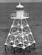
Light is still standing, but the lantern has been removed, and a NOAA
automatic weather station
now sits at the top of the tower. The tower, which is painted brown, stands in 9 feet (2.7 m) of water.
indicates that a lightship
was stationed at Pacific Reef starting in 1838. The Pacific Reef Light erected in 1921 is still operational. The lantern has been removed and is on public display in Founder's Park in Islamorada, Florida
. The tower is painted white and stands in 7 feet (2.1 m) of water.
. The lantern has been removed. The tower is painted red and stands in 19 feet (5.8 m) of water.

structure was developed in 1932 and used for the next four lights. It was a skeletal hexagonal pyramidal tower on a screw-pile foundation.
Light was one of the two lights to be erected in 1933 using the 1932 design. It stands in 15 feet (4.6 m) of water, and is painted black. The is the only one of the unmanned reef lights in the Florida Keys that still has its lantern.
 The Pulaski Shoal Light was one of the two lights to be erected in 1935 using the 1932 design. It stood in 15 feet (4.6 m) of water and was painted black. It apparently no longer exists.
Florida Keys
The Florida Keys are a coral archipelago in southeast United States. They begin at the southeastern tip of the Florida peninsula, about south of Miami, and extend in a gentle arc south-southwest and then westward to Key West, the westernmost of the inhabited islands, and on to the uninhabited Dry...
were erected between 1921 and 1935. As they were marking local hazards, they did not need to be visible for as far as the reef lights that were erected during the 19th century. By the time these lights were erected, older lighthouses were being automated, and these new lights were designed to be automated from the start. The lights resembled the older reef lights in having a skeletal pyramidal upper structure on screw-pile
Screw-pile lighthouse
A screw-pile lighthouse is a lighthouse which stands on piles that are screwed into sandy or muddy sea or river bottoms. The first screw-pile lighthouse was built by blind Irish engineer Alexander Mitchell...
foundations. They all originally had lanterns on their peaks, so that they looked like smaller versions of the older reef lights, but had no keeper's quarters.
| Foundation: | screw-pile Screw-pile lighthouse A screw-pile lighthouse is a lighthouse which stands on piles that are screwed into sandy or muddy sea or river bottoms. The first screw-pile lighthouse was built by blind Irish engineer Alexander Mitchell... |
|---|---|
| Construction: | wrought iron Wrought iron thumb|The [[Eiffel tower]] is constructed from [[puddle iron]], a form of wrought ironWrought iron is an iron alloy with a very low carbon... |
1921 Design
The first two unmanned lights in the Florida Keys, the Molasses Reef Light and the Pacific Reef Light, were built to the same plan in 1921.| Tower shape: | square skeleton tower on piles |
|---|---|
| Height: | 45 feet (13.7 m) |
| Original lens: | fourth order Fresnel lens Fresnel lens A Fresnel lens is a type of lens originally developed by French physicist Augustin-Jean Fresnel for lighthouses.The design allows the construction of lenses of large aperture and short focal length without the mass and volume of material that would be required by a lens of conventional design... |
Molasses Reef Light
The Molasses ReefMolasses Reef
Molasses Reef is a coral reef located within the Florida Keys National Marine Sanctuary. It lies to the southeast of Key Largo, within the Key Largo Existing Management Area, which is immediately to the east of John Pennekamp Coral Reef State Park...
Light is still standing, but the lantern has been removed, and a NOAA
National Oceanic and Atmospheric Administration
The National Oceanic and Atmospheric Administration , pronounced , like "noah", is a scientific agency within the United States Department of Commerce focused on the conditions of the oceans and the atmosphere...
automatic weather station
Automatic weather station
An automatic weather station is an automated version of the traditional weather station, either to save human labour or to enable measurements from remote areas...
now sits at the top of the tower. The tower, which is painted brown, stands in 9 feet (2.7 m) of water.
| Location: | about 8 miles (12.9 km) southeast of Key Largo Key Largo Key Largo is an island in the upper Florida Keys archipelago and, at long, the largest of the Keys. It is also the northernmost of the Florida Keys in Monroe County, and the northernmost of the Keys connected by U.S. Highway 1... |
|---|---|
| Coordinates Geographic coordinate system A geographic coordinate system is a coordinate system that enables every location on the Earth to be specified by a set of numbers. The coordinates are often chosen such that one of the numbers represent vertical position, and two or three of the numbers represent horizontal position... WGS-84 (GPS Global Positioning System The Global Positioning System is a space-based global navigation satellite system that provides location and time information in all weather, anywhere on or near the Earth, where there is an unobstructed line of sight to four or more GPS satellites... ) |
25°01′N 80°23′W |
| Year first lit: | 1921 |
| Characteristic: Characteristic light A light characteristic is a graphic and text description of a navigational light sequence or colour displayed on a nautical chart or in a Light List with the chart symbol for a lighthouse, lightvessel, buoy or sea mark with a light on it. The graphic indicates how the real light beacon may be... |
Flashing white |
Pacific Reef Light
The United States Coast GuardUnited States Coast Guard
The United States Coast Guard is a branch of the United States Armed Forces and one of the seven U.S. uniformed services. The Coast Guard is a maritime, military, multi-mission service unique among the military branches for having a maritime law enforcement mission and a federal regulatory agency...
indicates that a lightship
Lightship
Lightship may refer to:* Lightvessel, a permanently moored ship that has light beacons mounted as navigational aids* Light displacement, a displacement figure that measures a ship complete in all respects, but without consumables, stores, cargo, crew, and effects*Lightship, a type of blimp operated...
was stationed at Pacific Reef starting in 1838. The Pacific Reef Light erected in 1921 is still operational. The lantern has been removed and is on public display in Founder's Park in Islamorada, Florida
Islamorada, Florida
Islamorada, a "Village of Islands," is an incorporated village in Monroe County, Florida, United States. It is located on the islands of Tea Table Key, Lower Matecumbe Key, Upper Matecumbe Key, Windley Key and Plantation Key in the Florida Keys....
. The tower is painted white and stands in 7 feet (2.1 m) of water.
| Location: | about 3 miles (4.8 km) southeast of Elliott Key Elliott Key Elliott Key is the northernmost of the true Florida Keys , and the largest key north of Key Largo. It is located entirely within Biscayne National Park, in Miami-Dade County, Florida, east of Homestead, Florida... |
|---|---|
| Coordinates Geographic coordinate system A geographic coordinate system is a coordinate system that enables every location on the Earth to be specified by a set of numbers. The coordinates are often chosen such that one of the numbers represent vertical position, and two or three of the numbers represent horizontal position... WGS-84 (GPS Global Positioning System The Global Positioning System is a space-based global navigation satellite system that provides location and time information in all weather, anywhere on or near the Earth, where there is an unobstructed line of sight to four or more GPS satellites... ) |
25°22′N 80°09′W |
| Year first lit: | 1921 |
| Characteristic: Characteristic light A light characteristic is a graphic and text description of a navigational light sequence or colour displayed on a nautical chart or in a Light List with the chart symbol for a lighthouse, lightvessel, buoy or sea mark with a light on it. The graphic indicates how the real light beacon may be... |
Flashing white, 0.4 seconds |
Hen and Chickens Shoal Light
The Hen and Chickens Shoal Light was the smallest of these lights, and the only one built as a triangular pyramid. It still exists, serving as a daymarkSea mark
A sea mark, also seamark and navigation mark, is a form of aid to navigation and pilotage aid which identifies the approximate position of a maritime channel, hazard and administrative area to allow boats, ships and seaplanes to navigate safely....
. The lantern has been removed. The tower is painted red and stands in 19 feet (5.8 m) of water.
| Location: | about 2 miles (3.2 km) southeast of Plantation Key Plantation Key Plantation Key is an island in Monroe County, Florida, United States. It is located in the upper Florida Keys on U.S. 1 , between Key Largo and Windley Key.... |
|---|---|
| Coordinates Geographic coordinate system A geographic coordinate system is a coordinate system that enables every location on the Earth to be specified by a set of numbers. The coordinates are often chosen such that one of the numbers represent vertical position, and two or three of the numbers represent horizontal position... WGS-84 (GPS Global Positioning System The Global Positioning System is a space-based global navigation satellite system that provides location and time information in all weather, anywhere on or near the Earth, where there is an unobstructed line of sight to four or more GPS satellites... ) |
24°56′N 80°33′W |
| Year first lit: | 1929 |
| Tower shape: | triangular skeleton tower on piles |
| Height: | 35 feet (10.7 m) |
| Original lens: | Range lens (acetylene gas, compressed) |
| Characteristic: Characteristic light A light characteristic is a graphic and text description of a navigational light sequence or colour displayed on a nautical chart or in a Light List with the chart symbol for a lighthouse, lightvessel, buoy or sea mark with a light on it. The graphic indicates how the real light beacon may be... |
Flashing red, 3 seconds |
1932 Design
A design for a standardized wrought ironWrought iron
thumb|The [[Eiffel tower]] is constructed from [[puddle iron]], a form of wrought ironWrought iron is an iron alloy with a very low carbon...
structure was developed in 1932 and used for the next four lights. It was a skeletal hexagonal pyramidal tower on a screw-pile foundation.
| Tower shape: | hexagonal skeleton tower on piles |
|---|---|
| Height: | 49 feet (14.9 m) |
Smith Shoal Light
The Smith Shoal Light was one of the two lights to be erected in 1933 using the 1932 design. It stood in 20 feet (6.1 m) of water. The tower was painted white. The tower apparently no longer exists.| Location: | about 11 miles (17.7 km) northnorthwest of Key West Key West Key West is an island in the Straits of Florida on the North American continent at the southernmost tip of the Florida Keys. Key West is home to the southernmost point in the Continental United States; the island is about from Cuba.... |
|---|---|
| Coordinates Geographic coordinate system A geographic coordinate system is a coordinate system that enables every location on the Earth to be specified by a set of numbers. The coordinates are often chosen such that one of the numbers represent vertical position, and two or three of the numbers represent horizontal position... WGS-84 (GPS Global Positioning System The Global Positioning System is a space-based global navigation satellite system that provides location and time information in all weather, anywhere on or near the Earth, where there is an unobstructed line of sight to four or more GPS satellites... ) |
24°43′N 81°55′W |
| Year first lit: | 1933 |
| Original lens: | fourth order Fresnel lens Fresnel lens A Fresnel lens is a type of lens originally developed by French physicist Augustin-Jean Fresnel for lighthouses.The design allows the construction of lenses of large aperture and short focal length without the mass and volume of material that would be required by a lens of conventional design... |
| Characteristic: Characteristic light A light characteristic is a graphic and text description of a navigational light sequence or colour displayed on a nautical chart or in a Light List with the chart symbol for a lighthouse, lightvessel, buoy or sea mark with a light on it. The graphic indicates how the real light beacon may be... |
Flashing white, once a second |
Tennessee Reef Light
The Tennessee ReefTennessee Reef
Tennessee Reef is a coral reef located within the Florida Keys National Marine Sanctuary. It lies to the southeast of Long Key. It consists of drowned spur-and-groove reef. Much of the reef is within a designated "Research Only" zone....
Light was one of the two lights to be erected in 1933 using the 1932 design. It stands in 15 feet (4.6 m) of water, and is painted black. The is the only one of the unmanned reef lights in the Florida Keys that still has its lantern.
| Location: | south of Long Key Long Key Long Key is an island in the middle Florida Keys.U.S. 1 crosses the key at approximately mile markers 65.5--71, between Fiesta Key and Conch Key.... |
|---|---|
| Coordinates Geographic coordinate system A geographic coordinate system is a coordinate system that enables every location on the Earth to be specified by a set of numbers. The coordinates are often chosen such that one of the numbers represent vertical position, and two or three of the numbers represent horizontal position... WGS-84 (GPS Global Positioning System The Global Positioning System is a space-based global navigation satellite system that provides location and time information in all weather, anywhere on or near the Earth, where there is an unobstructed line of sight to four or more GPS satellites... ) |
24°45′N 80°47′W |
| Year first lit: | 1933 |
| Original lens: | fourth order Fresnel lens Fresnel lens A Fresnel lens is a type of lens originally developed by French physicist Augustin-Jean Fresnel for lighthouses.The design allows the construction of lenses of large aperture and short focal length without the mass and volume of material that would be required by a lens of conventional design... |
| Characteristic: Characteristic light A light characteristic is a graphic and text description of a navigational light sequence or colour displayed on a nautical chart or in a Light List with the chart symbol for a lighthouse, lightvessel, buoy or sea mark with a light on it. The graphic indicates how the real light beacon may be... |
Flashing white, 0.3 seconds |
Cosgrove Shoal Light
The Cosgrove Shoal Light was one of the two lights to be erected in 1935 using the 1932 design. It stood in 14 feet (4.3 m) of water. The tower was painted red. It apparently no longer exists.| Location: | about 10 miles (16.1 km) westsouthwest of Key West Key West Key West is an island in the Straits of Florida on the North American continent at the southernmost tip of the Florida Keys. Key West is home to the southernmost point in the Continental United States; the island is about from Cuba.... , south of the Marquesas Keys Marquesas Keys The Marquesas Keys form an uninhabited island group about 30 miles west of Key West, 4 miles in diameter, and inhabited by mangrove. They are an unincorporated area of Monroe County, Florida and belong to the Lower Keys Census County Division. They are protected as part of the Key West National... |
|---|---|
| Year first lit: | 1935 |
| Original lens: | 200 mm |
| Characteristic: Characteristic light A light characteristic is a graphic and text description of a navigational light sequence or colour displayed on a nautical chart or in a Light List with the chart symbol for a lighthouse, lightvessel, buoy or sea mark with a light on it. The graphic indicates how the real light beacon may be... |
Flashing white: 4 flashes 0.4 seconds each, 3 eclipses 1.6 seconds each, 1 eclipse 5.6 seconds |
Pulaski Shoal Light
| Location: | about 30 miles (48.3 km) northwest of Key West Key West Key West is an island in the Straits of Florida on the North American continent at the southernmost tip of the Florida Keys. Key West is home to the southernmost point in the Continental United States; the island is about from Cuba.... , north of the Dry Tortugas Dry Tortugas The Dry Tortugas are a small group of islands, located at the end of the Florida Keys, USA, about west of Key West, and west of the Marquesas Keys, the closest islands. Still further west is the Tortugas Bank, which is completely submerged. The first Europeans to discover the islands were the... |
|---|---|
| Year first lit: | 1935 |
| Original lens: | 500 mm |
| Characteristic: Characteristic light A light characteristic is a graphic and text description of a navigational light sequence or colour displayed on a nautical chart or in a Light List with the chart symbol for a lighthouse, lightvessel, buoy or sea mark with a light on it. The graphic indicates how the real light beacon may be... |
Flashing white, flash 0.4 seconds eclipse 2.6 seconds |