

Sea mark
Encyclopedia
Navigation
Navigation is the process of monitoring and controlling the movement of a craft or vehicle from one place to another. It is also the term of art used for the specialized knowledge used by navigators to perform navigation tasks...
mark, is a form of aid to navigation and pilotage
Pilotage
Pilotage is the use of fixed visual references on the ground or sea by means of sight or radar to guide oneself to a destination, sometimes with the help of a map or nautical chart. People use pilotage for activities such as guiding vessels and aircraft, hiking and Scuba diving...
aid which identifies the approximate position of a maritime
Sea
A sea generally refers to a large body of salt water, but the term is used in other contexts as well. Most commonly, it means a large expanse of saline water connected with an ocean, and is commonly used as a synonym for ocean...
channel, hazard and administrative area to allow boat
Boat
A boat is a watercraft of any size designed to float or plane, to provide passage across water. Usually this water will be inland or in protected coastal areas. However, boats such as the whaleboat were designed to be operated from a ship in an offshore environment. In naval terms, a boat is a...
s, ship
Ship
Since the end of the age of sail a ship has been any large buoyant marine vessel. Ships are generally distinguished from boats based on size and cargo or passenger capacity. Ships are used on lakes, seas, and rivers for a variety of activities, such as the transport of people or goods, fishing,...
s and seaplane
Seaplane
A seaplane is a fixed-wing aircraft capable of taking off and landing on water. Seaplanes that can also take off and land on airfields are a subclass called amphibian aircraft...
s to navigate safely.
There are three types of sea mark:
- beacons - fixed to the seabedSeabedThe seabed is the bottom of the ocean.- Ocean structure :Most of the oceans have a common structure, created by common physical phenomena, mainly from tectonic movement, and sediment from various sources...
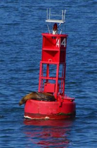
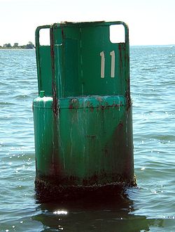
- buoyBuoyA buoy is a floating device that can have many different purposes. It can be anchored or allowed to drift. The word, of Old French or Middle Dutch origin, is now most commonly in UK English, although some orthoepists have traditionally prescribed the pronunciation...
s - consisting of a floating object that is usually anchorAnchorAn anchor is a device, normally made of metal, that is used to connect a vessel to the bed of a body of water to prevent the vessel from drifting due to wind or current. The word derives from Latin ancora, which itself comes from the Greek ἄγκυρα .Anchors can either be temporary or permanent...
ed to a specific location on the bottom of the sea or to a submerged object - A type of cairnCairnCairn is a term used mainly in the English-speaking world for a man-made pile of stones. It comes from the or . Cairns are found all over the world in uplands, on moorland, on mountaintops, near waterways and on sea cliffs, and also in barren desert and tundra areas...
built on a submerged rock/object, especially in calmer waters.
Sea marks are used to indicate channels, dangerous rocks or shoal
Shoal
Shoal, shoals or shoaling may mean:* Shoal, a sandbank or reef creating shallow water, especially where it forms a hazard to shipping* Shoal draught , of a boat with shallow draught which can pass over some shoals: see Draft...
s, mooring positions, areas of speed limits, traffic separation schemes, submerged shipwreck
Shipwreck
A shipwreck is what remains of a ship that has wrecked, either sunk or beached. Whatever the cause, a sunken ship or a wrecked ship is a physical example of the event: this explains why the two concepts are often overlapping in English....
s, and for a variety of other navigational purposes. Some are only intended to be visible in daylight (daymarks
Day beacon
A day beacon is an unlighted nautical sea mark. Typically, day beacons mark channels whose key points are marked by lighted buoys. Day beacons may also mark smaller navigable routes in their entirety. They are the most common aid to nautical navigation in shallow water as they are relatively...
), others have some combination of lights, reflectors, bells, horns, whistles and radar reflectors to make them usable at night and in conditions of reduced visibility.
Marks are shown on nautical chart
Nautical chart
A nautical chart is a graphic representation of a maritime area and adjacent coastal regions. Depending on the scale of the chart, it may show depths of water and heights of land , natural features of the seabed, details of the coastline, navigational hazards, locations of natural and man-made aids...
s, using symbols that indicate their colour, shape and light characteristic, and are usually identified by name or number.
The International Association of Lighthouse Authorities
International Association of Lighthouse Authorities
The International Association of Marine Aids to Navigation and Lighthouse Authorities is a non-profit organization founded in 1957 to collect and provide nautical expertise and advice.-Background:...
defines one system of marks specifying the shape
Shape
The shape of an object located in some space is a geometrical description of the part of that space occupied by the object, as determined by its external boundary – abstracting from location and orientation in space, size, and other properties such as colour, content, and material...
s, colours and characteristic light
Characteristic light
A light characteristic is a graphic and text description of a navigational light sequence or colour displayed on a nautical chart or in a Light List with the chart symbol for a lighthouse, lightvessel, buoy or sea mark with a light on it. The graphic indicates how the real light beacon may be...
s of buoys depending on their purpose, the IALA Maritime Buoyage System. For historical reasons, there are two regions of lateral mark
Lateral mark
A lateral buoy, lateral post or lateral mark, as defined by the International Association of Lighthouse Authorities, is a sea mark used in maritime pilotage to indicate the edge of a channel....
s in use:
- IALA Region B in the AmericasAmericasThe Americas, or America , are lands in the Western hemisphere, also known as the New World. In English, the plural form the Americas is often used to refer to the landmasses of North America and South America with their associated islands and regions, while the singular form America is primarily...
, the PhilippinesPhilippinesThe Philippines , officially known as the Republic of the Philippines , is a country in Southeast Asia in the western Pacific Ocean. To its north across the Luzon Strait lies Taiwan. West across the South China Sea sits Vietnam...
, South KoreaSouth KoreaThe Republic of Korea , , is a sovereign state in East Asia, located on the southern portion of the Korean Peninsula. It is neighbored by the People's Republic of China to the west, Japan to the east, North Korea to the north, and the East China Sea and Republic of China to the south...
and JapanJapanJapan is an island nation in East Asia. Located in the Pacific Ocean, it lies to the east of the Sea of Japan, China, North Korea, South Korea and Russia, stretching from the Sea of Okhotsk in the north to the East China Sea and Taiwan in the south... - IALA Region A everywhere else.
The two regions differ principally in the colours used to denote the two sides of a channel. When approaching a harbour from seaward, Region A places conical green marks to starboard and cylindrical red ones to port. In Region B these are replaced with conical red marks to starboard and cylindrical green ones to port. This can be remembered (for Region B) with the mnemonic "Red, right, return". Another Region B mnemonic, which also helps with buoy numbering is "Even Red Left Port" (as in Eric the Red) - Even Numbered buoys are red, on your left (port) side leaving port. In any case, since in many harbours it is not always apparent which direction is seaward, buoys should be used in connection with the appropriate nautical chart
Nautical chart
A nautical chart is a graphic representation of a maritime area and adjacent coastal regions. Depending on the scale of the chart, it may show depths of water and heights of land , natural features of the seabed, details of the coastline, navigational hazards, locations of natural and man-made aids...
. Additionally, since marks may be off station due to collision with ships, storms or other factors, they should be used with caution and not relied on solely for navigation
Navigation
Navigation is the process of monitoring and controlling the movement of a craft or vehicle from one place to another. It is also the term of art used for the specialized knowledge used by navigators to perform navigation tasks...
. The two regions are often referred to as two systems, which was the original intent. In 1980 it was decided however to combine these systems and distinguish between regions.
In a wider sense the word sea mark is often understood to include all kinds of landmarks, structures and devices that can be used to provide warning and guiding signals to mariners. Thus a sea mark can be and often is located on dry land. Examples of land-based sea marks are various signal lights and leading marks. The latter are mainly used to indicate the centerline of a fairway in narrow passages.
See also
- BuoyBuoyA buoy is a floating device that can have many different purposes. It can be anchored or allowed to drift. The word, of Old French or Middle Dutch origin, is now most commonly in UK English, although some orthoepists have traditionally prescribed the pronunciation...
- Cardinal markCardinal markA cardinal mark is a sea mark used in maritime pilotage to indicate the position of a hazard and the direction of safe water....
- LightvesselLightvesselA lightvessel, or lightship, is a ship which acts as a lighthouse. They are used in waters that are too deep or otherwise unsuitable for lighthouse construction...
- LighthouseLighthouseA lighthouse is a tower, building, or other type of structure designed to emit light from a system of lamps and lenses or, in older times, from a fire, and used as an aid to navigation for maritime pilots at sea or on inland waterways....
- LandmarkLandmarkThis is a list of landmarks around the world.Landmarks may be split into two categories - natural phenomena and man-made features, like buildings, bridges, statues, public squares and so forth...
- Lateral markLateral markA lateral buoy, lateral post or lateral mark, as defined by the International Association of Lighthouse Authorities, is a sea mark used in maritime pilotage to indicate the edge of a channel....
- RaconRaconA racon is a radar transponder commonly used to mark maritime navigational hazards. The word is a portmanteau of RAdar and beaCON.When a racon receives a radar pulse, it responds with a signal on the same frequency which puts an image on the radar display...
- ATONAtonThe term Aton may refer to:* Aten or Aton, the disk of the sun, regarded as a deity in ancient Egyptian mythology* Aton Capital, a Russian investment bank* ATON, abbreviation for Aid to Navigation* Archive of Turkish Oral NarrativePeople...