
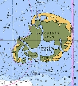
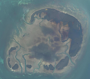
Marquesas Keys
Encyclopedia
The Marquesas Keys form an uninhabited island group about 30 miles (50 km) west of Key West
, 4 miles (6 km) in diameter, and inhabited by mangrove
. They are an unincorporated area
of Monroe County, Florida
and belong to the Lower Keys Census County Division
. They are protected as part of the Key West National Wildlife Refuge
. The Marquesas were used for target practice by the military as recently as 1980.
 The total area, including the lagoon
, measures 29.37 km². The land area, according to the United States Census Bureau
, is 6.58 km² (exactly 6,579,703 m²), the water area 0.17 km² (165,744 m²), with a combined area 6,75 km² (6,745,447 m²), whereby water areas with connection to the open sea are not counted, but only small landlocked lakes on the Keys. The group is located at coordinates 24°34′19"N 82°07′10"W.
The islands are part of the Florida Keys
, separated from the rest of the Florida Keys, which are farther east, by the Boca Grande Channel, which is 6 miles (10 km) wide until Boca Grande Key, the westernmost of the Mule Keys
. Only the Dry Tortugas
are farther west, 36 miles (60 km) west of the Marquesas Keys.
The central lagoon
is called Mooney Harbor. The northernmost key is the largest and has a strip of sandy beach free of mangrove. In the past it was known as "Entrance Key". It surrounds the lagoon in the north and east. Adjoining in the south are smaller keys such as Gull Keys, Mooney Harbor Key, and finally about four unnamed keys in the southwest corner of the island. Older charts show that two of these keys once were named "Button Island" and "Round Island".
Six miles (10 km) west of the Marquesas Keys is Rebecca Shoal
.
The islands are best known for their excellent sport fishing.
Key West
Key West is an island in the Straits of Florida on the North American continent at the southernmost tip of the Florida Keys. Key West is home to the southernmost point in the Continental United States; the island is about from Cuba....
, 4 miles (6 km) in diameter, and inhabited by mangrove
Mangrove
Mangroves are various kinds of trees up to medium height and shrubs that grow in saline coastal sediment habitats in the tropics and subtropics – mainly between latitudes N and S...
. They are an unincorporated area
Unincorporated area
In law, an unincorporated area is a region of land that is not a part of any municipality.To "incorporate" in this context means to form a municipal corporation, a city, town, or village with its own government. An unincorporated community is usually not subject to or taxed by a municipal government...
of Monroe County, Florida
Monroe County, Florida
Monroe County is a county located in the state of Florida. As of 2000, the population was 79,589. The U.S. Census Bureau 2006 estimate for the county was 74,737....
and belong to the Lower Keys Census County Division
Minor civil division
Minor civil division is a term used by the United States Census Bureau to designate the primary governmental and/or administrative divisions of a county, such as a civil township, precinct, or magisterial district...
. They are protected as part of the Key West National Wildlife Refuge
Key West National Wildlife Refuge
The Key West National Wildlife Refuge is a 189,497 acre National Wildlife Refuge located in Monroe County, Florida, between Key West, Florida and the Dry Tortugas . Only 2,019 acres of land are above sea level, on several keys within the refuge. These keys are unpopulated and are also designated...
. The Marquesas were used for target practice by the military as recently as 1980.
Lagoon
A lagoon is a body of shallow sea water or brackish water separated from the sea by some form of barrier. The EU's habitat directive defines lagoons as "expanses of shallow coastal salt water, of varying salinity or water volume, wholly or partially separated from the sea by sand banks or shingle,...
, measures 29.37 km². The land area, according to the United States Census Bureau
United States Census Bureau
The United States Census Bureau is the government agency that is responsible for the United States Census. It also gathers other national demographic and economic data...
, is 6.58 km² (exactly 6,579,703 m²), the water area 0.17 km² (165,744 m²), with a combined area 6,75 km² (6,745,447 m²), whereby water areas with connection to the open sea are not counted, but only small landlocked lakes on the Keys. The group is located at coordinates 24°34′19"N 82°07′10"W.
The islands are part of the Florida Keys
Florida Keys
The Florida Keys are a coral archipelago in southeast United States. They begin at the southeastern tip of the Florida peninsula, about south of Miami, and extend in a gentle arc south-southwest and then westward to Key West, the westernmost of the inhabited islands, and on to the uninhabited Dry...
, separated from the rest of the Florida Keys, which are farther east, by the Boca Grande Channel, which is 6 miles (10 km) wide until Boca Grande Key, the westernmost of the Mule Keys
Mule Keys
The Mule Keys is a group of scattered islets in the Florida Keys in Monroe County, Florida, United States. They are between 3 and 12 miles west of Key West, separated from it by the Northwest Channel. On the west, they are separated from the Marquesas Keys by 6 mile wide Boca Grande Channel....
. Only the Dry Tortugas
Dry Tortugas
The Dry Tortugas are a small group of islands, located at the end of the Florida Keys, USA, about west of Key West, and west of the Marquesas Keys, the closest islands. Still further west is the Tortugas Bank, which is completely submerged. The first Europeans to discover the islands were the...
are farther west, 36 miles (60 km) west of the Marquesas Keys.
The central lagoon
Lagoon
A lagoon is a body of shallow sea water or brackish water separated from the sea by some form of barrier. The EU's habitat directive defines lagoons as "expanses of shallow coastal salt water, of varying salinity or water volume, wholly or partially separated from the sea by sand banks or shingle,...
is called Mooney Harbor. The northernmost key is the largest and has a strip of sandy beach free of mangrove. In the past it was known as "Entrance Key". It surrounds the lagoon in the north and east. Adjoining in the south are smaller keys such as Gull Keys, Mooney Harbor Key, and finally about four unnamed keys in the southwest corner of the island. Older charts show that two of these keys once were named "Button Island" and "Round Island".
Six miles (10 km) west of the Marquesas Keys is Rebecca Shoal
Rebecca Shoal Light
The Rebecca Shoal Light was located on a treacherous coral bank, Rebecca Shoal, 10 km west of the Marquesas Keys and 50 km east of the Dry Tortugas. The bank has a least depth of 3.4 meters and is subject to strong currents and rough seas....
.
The islands are best known for their excellent sport fishing.