

Chilhowee (Cherokee town)
Encyclopedia

Native Americans in the United States
Native Americans in the United States are the indigenous peoples in North America within the boundaries of the present-day continental United States, parts of Alaska, and the island state of Hawaii. They are composed of numerous, distinct tribes, states, and ethnic groups, many of which survive as...
site in Blount County
Blount County, Tennessee
Blount County is a U.S. county located in the U.S. state of Tennessee. Its population was 123,010 at the United States Census, 2010. The county seat is at Maryville, which is also the county's largest city....
and Monroe County, Tennessee, in the southeastern United States. Although now submerged by the Chilhowee Lake
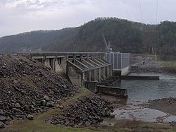
Chilhowee Dam
Chilhowee Dam is a hydroelectric dam located in Blount and Monroe counties, Tennessee, between river mile 33 and 34 on the Little Tennessee River. Construction began in 1955 and was completed in 1957. The dam's reservoir covers approximately at normal full pool and has a drainage area of . The...
impoundment of the Little Tennessee River
Little Tennessee River
The Little Tennessee River is a tributary of the Tennessee River, approximately 135 miles long, in the Appalachian Mountains in the southeastern United States.-Geography:...
, the Chilhowee site was home to a substantial 18th-century Overhill Cherokee
Overhill Cherokee
The term Overhill Cherokee refers to the former Cherokee settlements located in what is now Tennessee in the southeastern United States. The name was given by 18th century European traders and explorers who had to cross the Appalachian Mountains to reach these settlements when traveling from...
village and may have been the site of the Creek village "Chalahume" visited by Spanish explorer Juan Pardo
Juan Pardo (explorer)
Juan Pardo was a Spanish explorer and conquistador who was active in the later half of the sixteenth century. He led a Spanish expedition through what is now North and South Carolina and into eastern Tennessee. He established Fort San Felipe, South Carolina , and the village of Santa Elena on...
in 1567.
Although Chilhowee was destroyed by Euro-American frontiersmen in the late 18th century, the village's name is still used for various entities throughout East Tennessee. Along with Chilhowee Dam and its reservoir, places and entities named after Chilhowee include a mountain
Chilhowee Mountain
Chilhowee Mountain is a low ridge at the outer edge of the Great Smoky Mountains that stretches between the Little Tennessee River to the west and the Little Pigeon River watershed to the east...
, a geologic formation, several churches and schools, and a park
Chilhowee Park
Chilhowee Park is a public park, fairgrounds and exhibition venue in Knoxville, Tennessee, USA, located off Magnolia Avenue in East Knoxville. Developed in the late 19th century, the park is now home to the Tennessee Valley Fair, and hosts several dozen expositions annually...
and neighborhood
Chilhowee Park (neighborhood)
Chilhowee Park is a residential neighborhood in Knoxville, Tennessee, USA, located off Magnolia Avenue in the East Knoxville area. Developed as a streetcar suburb in the 1890s, this neighborhood was initially part of Park City, which was incorporated as a separate city in 1907, and annexed by...
in Knoxville
Knoxville, Tennessee
Founded in 1786, Knoxville is the third-largest city in the U.S. state of Tennessee, U.S.A., behind Memphis and Nashville, and is the county seat of Knox County. It is the largest city in East Tennessee, and the second-largest city in the Appalachia region...
.
Geographical setting
Tennessee River
The Tennessee River is the largest tributary of the Ohio River. It is approximately 652 miles long and is located in the southeastern United States in the Tennessee Valley. The river was once popularly known as the Cherokee River, among other names...
near Lenoir City
Lenoir City, Tennessee
Lenoir City is a city in Loudon County, Tennessee, United States. Its population was 8,642 at the 2010 census. It is included in the Knoxville Metropolitan Area....
. Chilhowee Dam, completed in 1957 by the Aluminum Company of America's Tapoco Division, is situated approximately 34 miles (54.7 km) above the mouth of the river. The dam has created Chilhowee Lake, a reservoir stretching for roughly 10 miles (16.1 km) between Chilhowee Dam and Calderwood Dam
Calderwood Dam
Calderwood Dam is a hydroelectric dam located along the Little Tennessee River in Blount and Monroe counties, Tennessee. Completed in 1930, the dam is owned and maintained by Tapoco, a subsidiary of the Aluminum Company of America , although the Tennessee Valley Authority controls the dam's...
, near the state line. Before inundation, the Chilhowee site was located along a bend in the Little Tennessee opposite the river's Abrams Creek confluence, approximately 36 miles (57.9 km) above river's mouth. The site is visible immediately southeast of the junction of U.S. Route 129
U.S. Route 129
U.S. Route 129 is an offshoot route of U.S. Route 29, which it intersects near Athens, Georgia. US 129 currently runs for 582 miles from Knoxville, Tennessee, to Chiefland, Florida, at U.S. Route 19 and U.S. Route 98. It passes through the states of Tennessee, North Carolina, Georgia and Florida...
and Foothills Parkway
Foothills Parkway
The Foothills Parkway is a national parkway which, if completed, will traverse the foothills of the northern Great Smoky Mountains in East Tennessee, located in the Southeastern United States. The 71-mile parkway will ideally connect U.S...
.
The Chilhowee site is situated in an area where the Appalachian Mountains
Appalachian Mountains
The Appalachian Mountains #Whether the stressed vowel is or ,#Whether the "ch" is pronounced as a fricative or an affricate , and#Whether the final vowel is the monophthong or the diphthong .), often called the Appalachians, are a system of mountains in eastern North America. The Appalachians...
— namely, the Great Smoky Mountains
Great Smoky Mountains
The Great Smoky Mountains are a mountain range rising along the Tennessee–North Carolina border in the southeastern United States. They are a subrange of the Appalachian Mountains, and form part of the Blue Ridge Physiographic Province. The range is sometimes called the Smoky Mountains or the...
to the northeast and the Unicoi Mountains
Unicoi Range
The Unicoi Mountains are a mountain range rising along the border between Tennessee and North Carolina in the southeastern United States. They are part of the Blue Ridge Mountain Province of the Southern Appalachian Mountains. The Unicois are located immediately south of the Great Smoky Mountains...
to the south— give way to the rolling hills of the Appalachian Ridge-and-Valley Province
Ridge-and-valley Appalachians
The Ridge-and-Valley Appalachians, also called the Ridge and Valley Province or the Valley and Ridge Appalachians, are a physiographic province of the larger Appalachian division and are also a belt within the Appalachian Mountains extending from southeastern New York through northwestern New...
. Chilhowee Lake provides part of the boundary between the Great Smoky Mountains National Park
Great Smoky Mountains National Park
Great Smoky Mountains National Park is a United States National Park and UNESCO World Heritage Site that straddles the ridgeline of the Great Smoky Mountains, part of the Blue Ridge Mountains, which are a division of the larger Appalachian Mountain chain. The border between Tennessee and North...
and the Cherokee National Forest
Cherokee National Forest
The Cherokee National Forest is a large National Forest created on July 19, 1936, by U.S. President Franklin Roosevelt, operated by the U.S. Forest Service and encompassing some 640,000 acres .-Location:...
.
Chalahume
According to anthropologist Charles Hudson, the Juan Pardo expedition entered the upper Tennessee Valley (then part of the ChiahaChiaha
Chiaha was a horticultural Native American chiefdom located in the lower French Broad River valley in modern East Tennessee, in the southeastern United States. They lived in raised structures within boundaries of several stable villages. These overlooked the fields of maize, beans, squash, and...
chiefdom) in late 1567 via the Pigeon River
Pigeon River (Tennessee - North Carolina)
The Pigeon River of western North Carolina and east Tennessee rises above Canton, North Carolina. Below this, it flows roughly parallel to Interstate 40 for many miles and is impounded by a dam -- Walters Dam -- belonging to Progress Energy before entering Tennessee, where it flows into the French...
, which Pardo followed to its confluence with the French Broad River
French Broad River
The French Broad River flows from near the village of Rosman in Transylvania County, North Carolina, into the state of Tennessee. Its confluence with the Holston River at Knoxville is the beginning of the Tennessee River....
near modern Newport
Newport, Tennessee
Newport is a city in Cocke County, Tennessee, United States. The population was 7,242 at the 2000 census. It is the county seat of Cocke County.-Geography:...
. The expedition rested for several days at the Chiaha capital of Olamico, which Hudson believes was located on Zimmerman's Island (now submerged by Douglas Lake
Douglas Dam
Douglas Dam is a hydroelectric dam on the French Broad River in Sevier County, Tennessee, in the southeastern United States. The dam is operated by the Tennessee Valley Authority , which built the dam in record time in the early 1940s to meet emergency energy demands at the height of World War II...
). On October 13, Pardo left Olamico, traveling southwest across the Foothills of the Great Smoky Mountains
Great Smoky Mountains
The Great Smoky Mountains are a mountain range rising along the Tennessee–North Carolina border in the southeastern United States. They are a subrange of the Appalachian Mountains, and form part of the Blue Ridge Physiographic Province. The range is sometimes called the Smoky Mountains or the...
en route to the Coosa chiefdom
Coosa chiefdom
The Coosa chiefdom was a powerful Native American paramount chiefdom near what are now Gordon and Murray counties in Georgia, in the United States. It was inhabited from about 1400 until about 1600, and dominated several smaller chiefdoms...
in northern Georgia. The expedition crossed Little River
Little River (Tennessee)
Little River is a scenic river in Tennessee which drains a area containing some of the most spectacular scenery in the southeastern United States. The first of the river are all located within the borders of the Great Smoky Mountains National Park...
near modern Walland
Walland, Tennessee
Walland is an unincorporated community in Blount County, Tennessee, in the Southeastern United States. Walland is the site of a post office and is the place name associated with zip code 37886, which covers an area beyond the Walland community...
and traversed Happy Valley
Happy Valley, Tennessee
Happy Valley is an unincorporated community in Blount County, Tennessee, United States, near the Great Smoky Mountains National Park. Although it is not a census-designated place, the ZIP Code Tabulation Area for the ZIP Code that serves Happy Valley had a population of 529 as of the 2000 U.S...
to reach "Chalahume" in the Little Tennessee Valley on October 15. Expedition notary Juan de la Bandera described Chalahume's topographic situation as similar to the Spanish city of Córdoba
Córdoba, Spain
-History:The first trace of human presence in the area are remains of a Neanderthal Man, dating to c. 32,000 BC. In the 8th century BC, during the ancient Tartessos period, a pre-urban settlement existed. The population gradually learned copper and silver metallurgy...
— a grapevine-filled valley at the base of high mountains— a description that fits Chilhowee.
Hudson points out that the phoneme
Phoneme
In a language or dialect, a phoneme is the smallest segmental unit of sound employed to form meaningful contrasts between utterances....
"/m/" is infrequent in the Cherokee language
Cherokee language
Cherokee is an Iroquoian language spoken by the Cherokee people which uses a unique syllabary writing system. It is the only Southern Iroquoian language that remains spoken. Cherokee is a polysynthetic language.-North American etymology:...
, and thus when the Cherokee replaced Chalahume's Mississippian-era occupants, they retained the site's name but substituted a "w" for the "m". A similar situation occurred 5 miles (8 km) downstream from Chilhowee at Citico
Citico (Tellico archaeological site)
Citico is a prehistoric and historic Native American site in Monroe County, Tennessee, in the southeastern United States. The site's namesake Cherokee village was the largest of the Overhill towns, housing an estimated population of 1,000 by the mid-18th century...
, which Hudson argues was the "Satapo" visited by the Pardo expedition on October 16.
The Cherokee period

Chilhowee doesn't appear among the Overhill towns until the mid-18th century, although its neighbors Citico and Tallassee
Tallassee (Cherokee town)
Tallassee is a prehistoric and historic Native American site in Blount County and Monroe County, Tennessee, in the southeastern United States. Tallassee was the southernmost of a string of Overhill Cherokee villages that spanned the lower Little Tennessee River in the 18th century...
appear in the earliest English records of the region. Colonel George Chicken, who visited the Overhill towns in 1725 in hopes of cementing an alliance against the Creeks, met at the Tanasi
Tanasi
Tanasi is a historic Overhill Cherokee village site in Monroe County, Tennessee, in the southeastern United States. The village is best known as the namesake for the state of Tennessee...
townhouse with the head men of Tanasi, Citico, Tallassee, Great Tellico
Great Tellico
Great Tellico was a Cherokee town at the site of present-day Tellico Plains, Tennessee, where the Tellico River emerges from the Appalachian Mountains. Great Tellico was one of the largest Cherokee towns in the region, and had a sister town nearby named Chatuga. Its name in Cherokee is more...
, and "Coosaw." George Hunter's map of the Overhill country shows Tallassee, Citico, Tanasi, and Great Tellico, but makes no mention of Chilhowee. Henry Timberlake
Henry Timberlake
Henry Timberlake was a colonial Anglo-American officer, journalist, and cartographer. He was born in Virginia in 1730 and died in England...
visited Chilhowee on a peace mission in 1761 and engaged in a pipe-smoking ceremony with the town's head men, but didn't elaborate. Timberlake's "Draught of the Cherokee Country" shows 18 dwellings and a townhouse at Chilhowee, and lists Yachtino as the town's chief. The 110 warriors reportedly residing at Chilhowee represented the third largest fighting contingent among the Overhill towns, behind only Citico and Chota
Chota (Cherokee town)
Chota is a historic Overhill Cherokee site in Monroe County, Tennessee, in the southeastern United States. For much of its history, Chota was the most important of the Overhill towns, serving as the de facto capital of the Cherokee people from the late 1740s until 1788...
.
The encroachment of Euro-American settlers into the Tennessee Valley in the 1770s led to increased conflict with the valley's Cherokee inhabitants. Around this time, the chief of Chilhowee, known as Old Abraham (or "Abram"), had risen to prominence among the Overhill Cherokees. When the Cherokee aligned themselves with the British at the outbreak of the American Revolution
American Revolutionary War
The American Revolutionary War , the American War of Independence, or simply the Revolutionary War, began as a war between the Kingdom of Great Britain and thirteen British colonies in North America, and ended in a global war between several European great powers.The war was the result of the...
in 1776, Old Abraham and Dragging Canoe
Dragging Canoe
Tsiyu Gansini , "He is dragging his canoe", known to whites as Dragging Canoe, was a Cherokee war chief who led a band of Cherokee against colonists and United States settlers...
(the head man at Mialoquo
Mialoquo
Mialoquo is a prehistoric and historic Native American site in Monroe County, Tennessee, in the southeastern United States. The site saw significant periods of occupation during the Mississippian period and later as a Cherokee refugee village...
) led a two-pronged attack against Fort Watauga
Fort Watauga
Fort Watauga, more properly Fort Caswell, was an American Revolutionary War fort that once stood at the Sycamore Shoals of the Watauga River in what is now Elizabethton, Tennessee...
and Heaton's Station, respectively. The expedition was a disaster, and prompted Virginia to dispatch Colonel William Christian
William Christian (Virginia)
William Christian was an "Indian fighter", Continental soldier, militiaman and politician from Virginia who served in the era of the American Revolution. He was a signatory to the Fincastle Resolutions and founder of Fort William...
with a small force to subdue the Overhill towns. Christian entered the Little Tennessee Valley unopposed and made a truce with several older chiefs, but when Dragging Canoe refused to accept a peace offering, Christian burned several Overhill towns, including Chilhowee. In 1788, Old Abraham and several other chiefs were tomahawked to death under a flag of truce by a son of John Kirk, a settler whose family was massacred by renegade Cherokees on Nine Mile Creek.
The site's later history
American Civil War
The American Civil War was a civil war fought in the United States of America. In response to the election of Abraham Lincoln as President of the United States, 11 southern slave states declared their secession from the United States and formed the Confederate States of America ; the other 25...
.
The Cherokee National Forest, established in 1911, now protects the western shoreline above Chilhowee Lake, and the Great Smoky Mountains National Park
Great Smoky Mountains National Park
Great Smoky Mountains National Park is a United States National Park and UNESCO World Heritage Site that straddles the ridgeline of the Great Smoky Mountains, part of the Blue Ridge Mountains, which are a division of the larger Appalachian Mountain chain. The border between Tennessee and North...
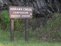
, established in 1932, protects the eastern shoreline. Abrams Creek, the longest stream located entirely within the park, is named for Old Abraham of Chilhowee. A campground and ranger station is located along the creek a few miles upstream from Chilhowee.
When ALCOA announced plans to build Chilhowee Dam in 1955, the Knoxville Chapter of the Tennessee Archaeological Society arranged to conduct salvage excavations at the Chilhowee site and the Tallassee site (near modern Calderwood
Calderwood, Tennessee
Calderwood was a community once located along the Little Tennessee River in Blount County, Tennessee, USA. Established in 1912 as a base for the Aluminum Company of America's Little Tennessee Valley hydroelectric development operations, the community continued to house construction personnel and...
), both of which would be flooded by the dam's reservoir. Due to the greater amount of surface material at Tallassee and the Tallassee site's accessibility, the Knoxville Chapter decided to focus on Tallassee, and conducted only limited surface collections at Chilhowee.