

Unaka Range
Encyclopedia
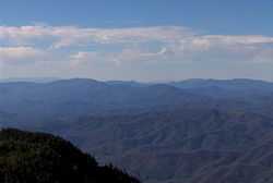
Mountain range
A mountain range is a single, large mass consisting of a succession of mountains or narrowly spaced mountain ridges, with or without peaks, closely related in position, direction, formation, and age; a component part of a mountain system or of a mountain chain...
on the border of Tennessee
Tennessee
Tennessee is a U.S. state located in the Southeastern United States. It has a population of 6,346,105, making it the nation's 17th-largest state by population, and covers , making it the 36th-largest by total land area...
and North Carolina
North Carolina
North Carolina is a state located in the southeastern United States. The state borders South Carolina and Georgia to the south, Tennessee to the west and Virginia to the north. North Carolina contains 100 counties. Its capital is Raleigh, and its largest city is Charlotte...
, in the southeastern United States. It is a subrange of the Appalachian Mountains
Appalachian Mountains
The Appalachian Mountains #Whether the stressed vowel is or ,#Whether the "ch" is pronounced as a fricative or an affricate , and#Whether the final vowel is the monophthong or the diphthong .), often called the Appalachians, are a system of mountains in eastern North America. The Appalachians...
and is part of the Blue Ridge Mountains
Blue Ridge Mountains
The Blue Ridge Mountains are a physiographic province of the larger Appalachian Mountains range. This province consists of northern and southern physiographic regions, which divide near the Roanoke River gap. The mountain range is located in the eastern United States, starting at its southern-most...
physiographic province. The Unakas stretch approximately from the Nolichucky River
Nolichucky River
The Nolichucky River is a major stream draining the Blue Ridge Mountains of western North Carolina and east Tennessee. The river is long.-Hydrography:...
to the south to the Watauga River
Watauga River
The Watauga River is a large stream of western North Carolina and East Tennessee. It is 60 miles long with its headwaters on the slopes of Grandfather Mountain and Peak Mountain in Watauga County, North Carolina.-Hydrography:...
to the north. The Unakas include the prominent Roan Highlands, where several summits rise above 6,000 feet. The Iron Mountains
Iron Mountains
The Iron Mountains are a minor range of the Appalachian Mountains. These mountains are located around the common meeting point of Tennessee, Virginia, and North Carolina...
border the Unakas to the north, and the Bald Mountains
Bald Mountains
The Bald Mountains are a mountain range rising along the border between Tennessee and North Carolina in the southeastern United States. They are part of the Blue Ridge Mountain Province of the Southern Appalachian Mountains...
border the Unakas opposite the Nolichucky to the south. The name unaka is rooted in the Cherokee
Cherokee language
Cherokee is an Iroquoian language spoken by the Cherokee people which uses a unique syllabary writing system. It is the only Southern Iroquoian language that remains spoken. Cherokee is a polysynthetic language.-North American etymology:...
term unega, meaning "white".
The Cherokee National Forest
Cherokee National Forest
The Cherokee National Forest is a large National Forest created on July 19, 1936, by U.S. President Franklin Roosevelt, operated by the U.S. Forest Service and encompassing some 640,000 acres .-Location:...
and the Pisgah National Forest
Pisgah National Forest
Pisgah National Forest is a National Forest in the Appalachian Mountains of western North Carolina. It is administered by the United States Forest Service, part of the United States Department of Agriculture. The Pisgah National Forest is completely contained within the state of North Carolina...
protect large sections of the Unaka Mountains. The Appalachian Trail
Appalachian Trail
The Appalachian National Scenic Trail, generally known as the Appalachian Trail or simply the AT, is a marked hiking trail in the eastern United States extending between Springer Mountain in Georgia and Mount Katahdin in Maine. It is approximately long...
traverses the Unaka crest.
In some geological and in historical sources, the term "Unaka Range" is used to identify the entire crest of the Appalachian Mountains along the Tennessee-North Carolina border, including the Unakas, the Great Smoky Mountains
Great Smoky Mountains
The Great Smoky Mountains are a mountain range rising along the Tennessee–North Carolina border in the southeastern United States. They are a subrange of the Appalachian Mountains, and form part of the Blue Ridge Physiographic Province. The range is sometimes called the Smoky Mountains or the...
, the Bald Mountains, the Unicoi Mountains, and the mountains in the Big Frog Wilderness
Big Frog Wilderness
The Big Frog Wilderness was designated in 1984 and currently consists of . Approximately are located in Georgia in the Chattahoochee National Forest and approximately are located in Tennessee in the Cherokee National Forest...
and Little Frog Mountain Wilderness.
Notable peaks
The highest point in the Unaka Range is Roan High KnobRoan Mountain (Roan Highlands)
Roan Mountain is the highpoint of the Roan-Unaka Range of the Southern Appalachian Mountains, located in the Southeastern United States. The mountain is clad in a dense stand of Southern Appalachian spruce-fir forest, and includes the world's largest natural rhododendron garden, and the longest...
, which rises to an elevation of 6285 feet (1,915.7 m).
| Peak Name Summit (topography) In topography, a summit is a point on a surface that is higher in elevation than all points immediately adjacent to it. Mathematically, a summit is a local maximum in elevation... |
Elevation (ft) | Land |  |
 |
Prominence | Isolation Topographic isolation The topographic isolation of a summit is the minimum horizontal distance to the nearest point of higher elevation. Topographic isolation represents a radius of dominance in which the summit is the highest point. Topographic isolation can be calculated for small hills and islands as well as for... |
|---|---|---|---|---|---|---|
| Roan High Knob | 6,285 | Cherokee/Pisgah | Mitchell Mitchell County, North Carolina -National protected areas:* Blue Ridge Parkway * Pisgah National Forest -Demographics:As of the census of 2000, there were 15,687 people, 6,551 households, and 4,736 families residing in the county. The population density was 71 people per square mile . There were 7,919 housing units at an... |
Carter Carter County, Tennessee Carter County is a county located in the U.S. state of Tennessee. As of 2010, the population was 57,424. Its county seat is Elizabethton.Carter County is part of the Johnson City Metropolitan Statistical Area, which is a component of the Johnson City–Kingsport–Bristol, TN-VA Combined... |
3,485 | 18.81 |
| Roan High Bluff | 6,178 | Pisgah | Mitchell | 187 | 1.54 | |
| Cloudland Mountain | 6,267 | Cherokee/Pisgah | Mitchell | Carter | ||
| Grassy Ridge Bald Grassy Ridge Bald Grassy Ridge Bald is a mountain in North Carolina and is part of the Roan Highlands, within the Pisgah National Forest. Its elevation reaches 6,165 feet and it is on the border between Avery and Mitchell counties. The mountain generates feeder streams for the North Toe River.... |
6,189 | Pisgah | Avery Avery County, North Carolina - Climate :As a result of its relatively high elevation, Avery County has a Humid continental climate enjoying considerably cooler summers than most of the rest of the Eastern US. Likewise, winters are longer, colder and snowier than most other locations in the region. This can be evidenced by the... , Mitchell |
688 | 2.35 | |
| Round Bald | 5,807 | Cherokee/Pisgah | Mitchell | Carter | ||
| Jane Bald | 5,807 | Cherokee/Pisgah | Mitchell | Carter | ||
| Hump Mountain | 5,587 | Pisgah | Avery | |||
| Little Yellow Mountain Little Yellow Mountain (North Carolina) Little Yellow Mountain is a mountain in the North Carolina High Country and wholly in the Pisgah National Forest. It's elevation reaches 5,504 feet , it is on the border between Avery and Mitchell counties... |
5,504 | Pisgah | Avery, Mitchell | |||
| Hawk Mountain | 5,443 | Pisgah | Mitchell | |||
| Big Yellow Mountain Big Yellow Mountain Big Yellow Mountain is a mountain in the North Carolina High Country and wholly in the Pisgah National Forest. It's elevation reaches 5,440 feet . The mountain generates feeder streams for the North Toe River.... |
5,440 | Pisgah | Avery | |||