
.gif)
U.S. Route 40 Alternate (Keysers Ridge – Cumberland, Maryland)
Encyclopedia
U.S. Route 40 Alternate () is the United States highway designation for a former segment of U.S. Route 40
(US 40) through Garrett
and Allegany
Counties in Maryland
. The highway begins at US 40 near exit 14 on Interstate 68
and runs 31.8 miles (51.2 km) eastward to Cumberland
, where it ends at exit 44 on Interstate 68. is maintained by the Maryland State Highway Administration
(MDSHA).
The highway is known as Old National Pike to reflect the fact that it follows the original alignment of the National Road
. As the route of the historic National Road, there are many historic sites along , including the Casselman Bridge
in Grantsville
and the last remaining National Road toll gate house in Maryland, located in LaVale.
When the National Freeway was built in western Maryland paralleling the old National Road, parts of U.S. Route 40 were bypassed. The part of the bypassed road between Keyser's Ridge and Cumberland became Alt US 40, and other bypassed sections east of Cumberland became Maryland Route 144
and U.S. Route 40 Scenic
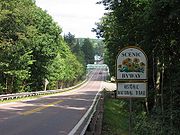
. Although has diminished in importance from its original status as the National Road due to the construction of Interstate 68, it remains an important route for local traffic and serves as the Main Streets of Grantsville
and Frostburg
.
, following part of the route of the National Road
through some of Maryland's most mountainous terrain in Garrett
and Allegany
counties.
near exit 14 on Interstate 68
at Keysers Ridge
. It runs parallel to Interstate 68
through northern Garrett County
as a two-lane road with truck lanes on some uphill sections. The annual average daily traffic
(AADT)—that is, the number of cars that use the road per day, averaged over the course of one year—is 1,831 at the western end of Alt US 40. For comparison, the parallel section of Interstate 68 has an AADT of 14,271. The terrain that passes through contains some of the most mountainous terrain in Maryland. The route runs perpendicular to the mountain ridges in Garrett County, and as a result much of the section of the road in Garrett County runs uphill or downhill. The first mountain encountered by the highway east of Keysers Ridge is Negro Mountain
. The road passes over the mountain at an elevation of 3075 feet (937.3 m), which is the highest point on , and was also the highest point along the National Road
. East of Negro Mountain, the highway enters Grantsville
, where traffic increases, with the AADT increasing to 3,711, the highest traffic density on Alt US 40 in Garrett County. In Grantsville, meets Maryland Route 669
, which connects with Pennsylvania Route 669
toward Salisbury, Pennsylvania
. A short distance east of this intersection, the highway meets Maryland Route 495
, which interchanges with Interstate 68 and continues southward toward Oakland
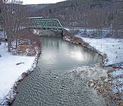
. East of Grantsville, passes over the Casselman River
on a steel bridge built in 1933. Downstream from this bridge is the Casselman River Bridge State Park, centered around the stone arch bridge which originally carried the National Road
over the Casselman River.
 Continuing eastward from Grantsville, intersects U.S. Route 219
a short distance north of exit 22 of Interstate 68, where US 219 leaves the freeway. East of this intersection, traffic decreases, with an AADT of 1,681, the lowest traffic density along the entire route. The US 219 intersection is at the top of a ridge known as Chestnut Ridge, which continues northward into Pennsylvania as the Laurel Highlands
.
East of Chestnut Ridge, the highway passes over Meadow Mountain at a height of 2789 feet (850.1 m). In eastern Garrett County, traffic on the route gradually increases to an AADT of 2,232. passes under Maryland Route 546
, which runs north from Interstate 68, through Finzel
, to the Pennsylvania border. Although does not directly intersect MD 546, it is connected to MD 546 by way of access road MD 546F, and also by Maryland Route 946, which intersects near the top of Little Savage Mountain. Just east, the route crosses the larger Big Savage Mountain at an elevation of 2847 feet (867.8 m) before entering Allegany County
.
, where it passes through the town as Main Street. Main Street in Frostburg has the highest traffic density on the route, with an AADT of 15,022. For comparison, the parallel section of Interstate 68 between exits 33 and 34 has an AADT of 20,931. In west Frostburg, the highway intersects Maryland Route 36
(MD 36), which then follows the same road as for about a mile, separating from in east Frostburg. In central Frostburg, Main Street intersects Maryland Route 936
, an old alignment of MD 36. Continuing eastward from Frostburg, traffic density decreases, to an AADT of 13,585 at the Maryland Route 55
(MD 55) intersection, staying between 13,000 and 15,000 for the remainder of the highway. passes through Eckhart Mines
, where it intersects Maryland Route 638
, which connects with MD 36 north of Frostburg. In the eastern part of Eckhart Mines, the highway intersects Maryland Route 743
(MD 743), which is an old alignment of US 40 which was bypassed by the roadway which became .
 East of Eckhart Mines, passes through Clarysville
, where it intersects MD 55. It is near Clarysville that the terrain followed by Alt US 40 changes: from Clarysville westward to the summit of Savage Mountain, the road runs uphill, while east of Clarysville, the road follows valleys, first following the valley around Braddock Run to Cumberland, and then following the valley around Wills Creek
into Cumberland. Near the MD 55 intersection is a stone arch bridge which was initially built in 1812 and rebuilt in the 1830s, and carried the National Road over Braddock Run, a tributary to Wills Creek. East of Clarysville, the highway passes through a gap carved by Braddock Run between Piney Mountain and Dan's Mountain. Interstate 68, having been built later, is located on the hillside above , on the Dan's Mountain side of the gap. then descends Red Hill into LaVale. At the bottom of Red Hill is the LaVale toll gate house. Built in 1836, tolls were collected there until the early 1900s, and it is the last original National Road toll gate house standing in Maryland. In LaVale, the route intersects Maryland Route 53
(MD 53), which serves as a truck bypass for U.S. Route 220
(US 220) to Cresaptown
. interchanges with westbound Interstate 68 at exit 39, but eastbound access is only available via MD 53 and Maryland Route 658
(MD 658), which intersects east of the exit 39 interchange. The highway expands to a four-lane road near its intersection with MD 53, then narrows to a two-lane road near its intersection with MD 658. East of the intersection with MD 658, turns northward, passing through LaVale toward the Narrows
, bypassing Haystack Mountain
to the north, as opposed to Interstate 68, which passes directly over Haystack Mountain, paralleling Braddock Road (MD 49)
.
Northeast of LaVale, intersects MD 36 at the northern terminus of MD 36. then passes through the Narrows
, a gap between Haystack Mountain and Wills Mountain
carved by Wills Creek
, into Cumberland
, where it follows Henderson Avenue and Baltimore Avenue to Exit 44 on Interstate 68
, where ends. The roadway continues eastward as Maryland Route 639
.
and Allegany
counties is, with some realignments, the route followed by the National Road
through western Maryland. Various historic sites associated with the National Road can be found along , including a toll-gate house (La Vale Tollgate House
) and mile-marker in LaVale. The toll-gate house in LaVale is the last remaining toll-gate house on the National Road in Maryland. Several historic bridges from the National Road, since bypassed by newer bridges, are still present along the route of , including the Casselman Bridge
over the Casselman River
in Grantsville
and a bridge in Clarysville
.
 In 1755, during the French and Indian War
, British troops under the command of General Edward Braddock
completed the arduous task of building a road westward from Fort Cumberland
. They largely followed an Indian trail known as Nemacolin's Path, expanding it to a 12 feet (3.7 m) wide road using only hand tools. The road construction was part of the Braddock expedition
, which was the British campaign to seize Fort Duquesne
from the French and Indian forces. Although the military expedition was a failure, the road continued to be used afterwards. However, with little maintenance being done on the road, it decayed over time until by the early nineteenth century little remained of the road. The route followed by Alt US 40 today is very similar to the route followed by Braddock's Road, with the exceptions of various realignments that have been done to the road over the years. For example, Braddock's Road crossed directly over Haystack Mountain west of Cumberland rather than following the Cumberland Narrows as later roads did.
The National Road, the first road funded by the U.S. federal government, was authorized by the United States Congress
in 1806, and ran from Cumberland, Maryland
to Vandalia, Illinois
. Construction started in 1811, and by 1837 the road reached Vandalia. Many sites from the National Road remain along , in particular the LaVale toll gate house, built in 1836. Following the completion of the National Road in 1837, the federal government ceded the road to the states to operate as a toll road, and toll gate houses such as the one in LaVale were built along its path in preparation for the transfer. Tolls continued to be collected along the National Road at the LaVale toll house until the late nineteenth century. The LaVale toll house is the first of its kind to be built along the National Road, and it is the last standing toll house along the National Road in Maryland. The LaVale toll house was listed on the National Register of Historic Places
in 1977.
. The previous route had followed the Braddock Road, a route which is now followed by MD 49
. The route following Braddock Road passed over Haystack Mountain
and was much steeper than the newer route through the Narrows. The route through the Narrows allowed the road to bypass this steep mountain ascent. The stone arch bridge built across Will's Creek for the new alignment remained in service until 1932, when a new bridge which is the present bridge across Will's Creek replaced it. The old bridge was torn down during the construction of the Will's Creek flood control system in the 1950s.
Another realignment of occurred in Eckhart Mines
, where in 1969 the road, then designated as US 40, was realigned to the north, bypassing the section of the highway through Eckhart Mines, which has a lower speed limit and sharp curves. The speed limit on the old alignment is 25 miles per hour (40.2 km/h), and the new alignment has a speed limit of 50 miles per hour (80.5 km/h) along most of the bypass. The new alignment intersects the old alignment, designated as MD 743
, on the east end between MD 638
and MD 55
. The west end of the old alignment meets MD 36
just south of its intersection with . MD 638, which prior to the realignment ended at US 40, was not truncated, and thus ends at MD 743.
 There are several historic bridges along the National Road that are still present near the current route of . Among them are the Casselman River bridge in Grantsville, and the bridge over Braddock Run, a tributary of Wills Creek
, in Clarysville. The original National Road bridge over the Casselman River was a stone arch bridge constructed in 1813. The 80 feet (24.4 m) span was built to be the largest bridge of its type in the United States at the time, and during its construction it was believed that the bridge could not stand on its own. The bridge was constructed in this manner in the hopes that the Chesapeake and Ohio Canal
would eventually pass under it, though construction on the canal was stopped at Cumberland
in 1850. When US 40 was first designated in 1925, it crossed the Casselman River on the original stone bridge. In 1933, a new steel bridge was constructed to replace the National Road bridge, and it is this bridge that now follows. The original bridge was declared a National Historic Landmark
in 1964, and is now part of the Casselman River Bridge State Park.
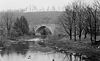
Another historic bridge stands in Clarysville, near the intersection of and MD 55
. This bridge, which crosses Braddock Run, was built in 1812, with later work being done in 1843. The stone arch bridge, located just south of the current alignment of , was restored in 1976.
, US 40 followed the route currently designated as U.S. Route 40 Alternate. The first segment of what would become Interstate 68 was built in Cumberland
in the mid-1960s. The freeway, first designated as US 48, was extended westward through the 1970s, finally being extended to West Virginia
in 1976. The portions of US 40 that were bypassed between Cumberland and Keyser's Ridge became U.S. Route 40 Alternate, which first appeared on MDSHA
maps in the early 1980s. At this time, US 40 was realigned to follow the US 48 freeway, sharing the freeway with US 48. In 1991 the freeway was completed from Hancock
to Morgantown, West Virginia
. The US 48 designation was retired, and on August 2, 1991, the freeway became Interstate 68.
U.S. Route 40
U.S. Route 40 is an east–west United States highway. As with most routes whose numbers end in a zero, U.S. 40 once traversed the entire United States. It is one of the original 1920s U.S. Highways, and its first termini were San Francisco, California, and Atlantic City, New Jersey...
(US 40) through Garrett
Garrett County, Maryland
Garrett County is the westernmost county of the U.S. state of Maryland. Created from Allegany County, Maryland in 1872 it was the last Maryland county to be formed. It was named for John Work Garrett , railroad executive, industrialist, and financier. Garrett served as president of the Baltimore...
and Allegany
Allegany County, Maryland
Allegany County is a county located in the northwestern part of the US state of Maryland. It is part of the Cumberland, MD-WV Metropolitan Statistical Area. As of 2010, the population was 75,087. Its county seat is Cumberland...
Counties in Maryland
Maryland
Maryland is a U.S. state located in the Mid Atlantic region of the United States, bordering Virginia, West Virginia, and the District of Columbia to its south and west; Pennsylvania to its north; and Delaware to its east...
. The highway begins at US 40 near exit 14 on Interstate 68
Interstate 68
Interstate 68 is a Interstate highway in the U.S. states of West Virginia and Maryland, connecting in Morgantown to in Hancock. is also Corridor E of the Appalachian Development Highway System. From 1965 until the freeway's construction was completed in 1991, it was designated as...
and runs 31.8 miles (51.2 km) eastward to Cumberland
Cumberland, Maryland
Cumberland is a city in the far western, Appalachian portion of Maryland, United States. It is the county seat of Allegany County, and the primary city of the Cumberland, MD-WV Metropolitan Statistical Area. At the 2010 census, the city had a population of 20,859, and the metropolitan area had a...
, where it ends at exit 44 on Interstate 68. is maintained by the Maryland State Highway Administration
Maryland State Highway Administration
The Maryland State Highway Administration is the state agency responsible for maintaining Maryland numbered highways outside of Baltimore City...
(MDSHA).
The highway is known as Old National Pike to reflect the fact that it follows the original alignment of the National Road
National Road
The National Road or Cumberland Road was the first major improved highway in the United States to be built by the federal government. Construction began heading west in 1811 at Cumberland, Maryland, on the Potomac River. It crossed the Allegheny Mountains and southwestern Pennsylvania, reaching...
. As the route of the historic National Road, there are many historic sites along , including the Casselman Bridge
Casselman Bridge, National Road
Casselman Bridge, also known as Casselmans Bridge, was completed in 1811 and opened for traffic in 1813 to carry the National Road across the Casselman River near Grantsville in western Maryland. The bridge was built to aid in the westward movement through the wilderness west of Cumberland...
in Grantsville
Grantsville, Maryland
Grantsville is a town in Garrett County, Maryland, United States. The population was 619 at the 2000 census.-History:Grantsville, 1/2 mile west of the Casselman River, began as a small Amish and Mennonite settlement, called Tomlinson's or Little Crossing, along Braddock rd., which wound westward...
and the last remaining National Road toll gate house in Maryland, located in LaVale.
When the National Freeway was built in western Maryland paralleling the old National Road, parts of U.S. Route 40 were bypassed. The part of the bypassed road between Keyser's Ridge and Cumberland became Alt US 40, and other bypassed sections east of Cumberland became Maryland Route 144
Maryland Route 144
Maryland Route 144 is a collection of state highways in the U.S. state of Maryland. These highways are sections of old alignment of U.S. Route 40 between Cumberland and Baltimore...
and U.S. Route 40 Scenic
U.S. Route 40 Scenic
U.S. Route 40 Scenic is a scenic route of U.S. Route 40 in the U.S. state of Maryland. US 40 Scenic is the old alignment of US 40 over Town Hill in eastern Allegany County and Sideling Hill in far western Washington County. The highway was originally constructed as part of the National Road in...
. Although has diminished in importance from its original status as the National Road due to the construction of Interstate 68, it remains an important route for local traffic and serves as the Main Streets of Grantsville
Grantsville, Maryland
Grantsville is a town in Garrett County, Maryland, United States. The population was 619 at the 2000 census.-History:Grantsville, 1/2 mile west of the Casselman River, began as a small Amish and Mennonite settlement, called Tomlinson's or Little Crossing, along Braddock rd., which wound westward...
and Frostburg
Frostburg, Maryland
Frostburg is a city in Allegany County, Maryland, United States located at the head of the Georges Creek Valley. It is part of the Cumberland, MD-WV Metropolitan Statistical Area. The population was 7,873 at the 2000 census...
.
Route description
runs from Keyser's Ridge to CumberlandCumberland, Maryland
Cumberland is a city in the far western, Appalachian portion of Maryland, United States. It is the county seat of Allegany County, and the primary city of the Cumberland, MD-WV Metropolitan Statistical Area. At the 2010 census, the city had a population of 20,859, and the metropolitan area had a...
, following part of the route of the National Road
National Road
The National Road or Cumberland Road was the first major improved highway in the United States to be built by the federal government. Construction began heading west in 1811 at Cumberland, Maryland, on the Potomac River. It crossed the Allegheny Mountains and southwestern Pennsylvania, reaching...
through some of Maryland's most mountainous terrain in Garrett
Garrett County, Maryland
Garrett County is the westernmost county of the U.S. state of Maryland. Created from Allegany County, Maryland in 1872 it was the last Maryland county to be formed. It was named for John Work Garrett , railroad executive, industrialist, and financier. Garrett served as president of the Baltimore...
and Allegany
Allegany County, Maryland
Allegany County is a county located in the northwestern part of the US state of Maryland. It is part of the Cumberland, MD-WV Metropolitan Statistical Area. As of 2010, the population was 75,087. Its county seat is Cumberland...
counties.
Garrett County
branches from US 40U.S. Route 40
U.S. Route 40 is an east–west United States highway. As with most routes whose numbers end in a zero, U.S. 40 once traversed the entire United States. It is one of the original 1920s U.S. Highways, and its first termini were San Francisco, California, and Atlantic City, New Jersey...
near exit 14 on Interstate 68
Interstate 68
Interstate 68 is a Interstate highway in the U.S. states of West Virginia and Maryland, connecting in Morgantown to in Hancock. is also Corridor E of the Appalachian Development Highway System. From 1965 until the freeway's construction was completed in 1991, it was designated as...
at Keysers Ridge
Keysers Ridge, Maryland
Keysers Ridge is an unincorporated area in northern Garrett County, Maryland. It lies to the west of Grantsville on Interstate 68 and is bounded to the northwest by the Savage River State Forest. It is primarily known for its key location on Interstate 68 and U.S. Route 40...
. It runs parallel to Interstate 68
Interstate 68
Interstate 68 is a Interstate highway in the U.S. states of West Virginia and Maryland, connecting in Morgantown to in Hancock. is also Corridor E of the Appalachian Development Highway System. From 1965 until the freeway's construction was completed in 1991, it was designated as...
through northern Garrett County
Garrett County, Maryland
Garrett County is the westernmost county of the U.S. state of Maryland. Created from Allegany County, Maryland in 1872 it was the last Maryland county to be formed. It was named for John Work Garrett , railroad executive, industrialist, and financier. Garrett served as president of the Baltimore...
as a two-lane road with truck lanes on some uphill sections. The annual average daily traffic
Annual average daily traffic
Average Annual daily traffic, abbreviated AADT, is a measure used primarily in transportation planning and transportation engineering. It is the total volume of vehicle traffic of a highway or road for a year divided by 365 days. AADT is a useful and simple measurement of how busy the road is...
(AADT)—that is, the number of cars that use the road per day, averaged over the course of one year—is 1,831 at the western end of Alt US 40. For comparison, the parallel section of Interstate 68 has an AADT of 14,271. The terrain that passes through contains some of the most mountainous terrain in Maryland. The route runs perpendicular to the mountain ridges in Garrett County, and as a result much of the section of the road in Garrett County runs uphill or downhill. The first mountain encountered by the highway east of Keysers Ridge is Negro Mountain
Negro Mountain
Negro Mountain is a long ridge of the Allegheny Mountains extending from Deep Creek Lake in Maryland, north to the Casselman River in Pennsylvania, USA. The summit, Mount Davis, is the highest point in Pennsylvania...
. The road passes over the mountain at an elevation of 3075 feet (937.3 m), which is the highest point on , and was also the highest point along the National Road
National Road
The National Road or Cumberland Road was the first major improved highway in the United States to be built by the federal government. Construction began heading west in 1811 at Cumberland, Maryland, on the Potomac River. It crossed the Allegheny Mountains and southwestern Pennsylvania, reaching...
. East of Negro Mountain, the highway enters Grantsville
Grantsville, Maryland
Grantsville is a town in Garrett County, Maryland, United States. The population was 619 at the 2000 census.-History:Grantsville, 1/2 mile west of the Casselman River, began as a small Amish and Mennonite settlement, called Tomlinson's or Little Crossing, along Braddock rd., which wound westward...
, where traffic increases, with the AADT increasing to 3,711, the highest traffic density on Alt US 40 in Garrett County. In Grantsville, meets Maryland Route 669
Maryland Route 669
Maryland Route 669 is a state highway in the U.S. state of Maryland. Known as Springs Road, the state highway runs from U.S. Route 40 Alternate in Grantsville north to the Pennsylvania state line, where the highway continues as Pennsylvania Route 669...
, which connects with Pennsylvania Route 669
Pennsylvania Route 669
Pennsylvania Route 669 is a long state highway located in Somerset county in Pennsylvania. The southern terminus is at the Maryland state line in Elk Lick Township, where Maryland Route 669 and Springs Road cross the state line from U.S. Route 40 Alternate...
toward Salisbury, Pennsylvania
Salisbury, Pennsylvania
Salisbury is a borough in Somerset County, Pennsylvania, United States. The population was 878 at the 2000 census. It is part of the Johnstown, Pennsylvania Metropolitan Statistical Area.-History:...
. A short distance east of this intersection, the highway meets Maryland Route 495
Maryland Route 495
Maryland Route 495 is a state highway in the U.S. state of Maryland. Known for most of its length as Bittinger Road, the state highway runs from MD 135 in Altamont north to U.S. Route 40 Alternate in Grantsville. MD 495 passes through rural areas of central Garrett County, connecting Bittinger...
, which interchanges with Interstate 68 and continues southward toward Oakland
Oakland, Maryland
Oakland is a town in the west-central part of Garrett County, Maryland, United States. With a population of 1,925 according to United States Census 2010 figures, it is the most populated community in Garrett County...
. East of Grantsville, passes over the Casselman River
Casselman River
The Casselman River is a tributary of the Youghiogheny River in western Maryland and Pennsylvania in the United States.The Casselman River rises atop the plateau of western Maryland and then follows a great arc across the Laurel Highlands of Somerset County, Pennsylvania to the appropriately named...
on a steel bridge built in 1933. Downstream from this bridge is the Casselman River Bridge State Park, centered around the stone arch bridge which originally carried the National Road
National Road
The National Road or Cumberland Road was the first major improved highway in the United States to be built by the federal government. Construction began heading west in 1811 at Cumberland, Maryland, on the Potomac River. It crossed the Allegheny Mountains and southwestern Pennsylvania, reaching...
over the Casselman River.
U.S. Route 219 in Maryland
U.S. Route 219 is a part of the U.S. Highway System that runs from Rich Creek, Virginia to West Seneca, New York. In the U.S. state of Maryland, the federal highway runs from the West Virginia state line near Red House to the Pennsylvania state line near Grantsville...
a short distance north of exit 22 of Interstate 68, where US 219 leaves the freeway. East of this intersection, traffic decreases, with an AADT of 1,681, the lowest traffic density along the entire route. The US 219 intersection is at the top of a ridge known as Chestnut Ridge, which continues northward into Pennsylvania as the Laurel Highlands
Laurel Highlands
The Laurel Highlands is a region in southwestern Pennsylvania made up of Fayette County, Somerset County and Westmoreland County. It has a population of about 600,000 people....
.
East of Chestnut Ridge, the highway passes over Meadow Mountain at a height of 2789 feet (850.1 m). In eastern Garrett County, traffic on the route gradually increases to an AADT of 2,232. passes under Maryland Route 546
Maryland Route 546
Maryland Route 546 is a state highway in the U.S. state of Maryland. Known as Finzel Road, state highway runs from Interstate 68 and U.S. Route 40 in Finzel in northeastern Garrett County north to the Pennsylvania state line, where the highway continues as State Route 2010 in Somerset County. ...
, which runs north from Interstate 68, through Finzel
Finzel, Maryland
Finzel is an unincorporated community in Garrett County, Maryland, United States. Finzel is located on Maryland Route 546 near the Pennsylvania border....
, to the Pennsylvania border. Although does not directly intersect MD 546, it is connected to MD 546 by way of access road MD 546F, and also by Maryland Route 946, which intersects near the top of Little Savage Mountain. Just east, the route crosses the larger Big Savage Mountain at an elevation of 2847 feet (867.8 m) before entering Allegany County
Allegany County, Maryland
Allegany County is a county located in the northwestern part of the US state of Maryland. It is part of the Cumberland, MD-WV Metropolitan Statistical Area. As of 2010, the population was 75,087. Its county seat is Cumberland...
.
Allegany County
After continuing into Allegany County, descends Savage Mountain into FrostburgFrostburg, Maryland
Frostburg is a city in Allegany County, Maryland, United States located at the head of the Georges Creek Valley. It is part of the Cumberland, MD-WV Metropolitan Statistical Area. The population was 7,873 at the 2000 census...
, where it passes through the town as Main Street. Main Street in Frostburg has the highest traffic density on the route, with an AADT of 15,022. For comparison, the parallel section of Interstate 68 between exits 33 and 34 has an AADT of 20,931. In west Frostburg, the highway intersects Maryland Route 36
Maryland Route 36
Maryland Route 36 is a state highway located in Allegany County, Maryland, United States. MD 36's southern terminus is at the WV 46 bridge in Westernport and its northern terminus at U.S. Route 40 Alternate near Cumberland...
(MD 36), which then follows the same road as for about a mile, separating from in east Frostburg. In central Frostburg, Main Street intersects Maryland Route 936
Maryland Route 936
Maryland Route 936 is a state highway in the U.S. state of Maryland. Known for most of its length as Upper Georges Creek Road, the state highway runs from Church Street in Midland north to U.S. Route 40 Alternate and MD 36 in Frostburg...
, an old alignment of MD 36. Continuing eastward from Frostburg, traffic density decreases, to an AADT of 13,585 at the Maryland Route 55
Maryland Route 55
Maryland Route 55 is a state highway in the U.S. state of Maryland. Known as Vale Summit Road, the state highway runs from MD 36 in Vale Summit north to U.S. Route 40 Alternate in Clarysville. MD 55 connects the La Vale area with Midland in the upper Georges Creek Valley in northwestern...
(MD 55) intersection, staying between 13,000 and 15,000 for the remainder of the highway. passes through Eckhart Mines
Eckhart Mines, Maryland
Eckhart Mines is an unincorporated town in Allegany County, Maryland, USA. Eckhart Mines lies at the southwestern base of Federal Hill, 2.9 km east of Frostburg and 1.3 km northwest of Clarysville. The town was originally founded as a company town for the nearby Eckhart Mines. The...
, where it intersects Maryland Route 638
Maryland Route 638
Maryland Route 638 is a state highway in the U.S. state of Maryland. Known as Parkersburg Road, the state highway runs from MD 743 in Eckhart Mines north to MD 36 near Mount Savage in northwestern Allegany County...
, which connects with MD 36 north of Frostburg. In the eastern part of Eckhart Mines, the highway intersects Maryland Route 743
Maryland Route 743
Maryland Route 743 is a state highway in the U.S. state of Maryland. The state highway runs from MD 36 in Frostburg east to U.S. Route 40 Alternate in Eckhart Mines. MD 743 is the original alignment of US 40 through Eckhart Mines...
(MD 743), which is an old alignment of US 40 which was bypassed by the roadway which became .
Clarysville, Maryland
Clarysville is an unincorporated town in Allegany County, Maryland, USA. It is located along U.S. Route 40 Alternate, at its intersection with Maryland Route 55. Clarysville was known around the region for the Clarysville Inn, a historic building which stood in Clarysville from 1807 until it burned...
, where it intersects MD 55. It is near Clarysville that the terrain followed by Alt US 40 changes: from Clarysville westward to the summit of Savage Mountain, the road runs uphill, while east of Clarysville, the road follows valleys, first following the valley around Braddock Run to Cumberland, and then following the valley around Wills Creek
Wills Creek (North Branch Potomac River)
Wills Creek is a tributary of the North Branch Potomac River in Pennsylvania and Maryland in the United States.Wills Creek drops off the Allegheny Mountains of southeastern Somerset County, Pennsylvania, and enters the North Branch Potomac River at Cumberland, Maryland.-History:thumb|220px|Fort...
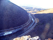
into Cumberland. Near the MD 55 intersection is a stone arch bridge which was initially built in 1812 and rebuilt in the 1830s, and carried the National Road over Braddock Run, a tributary to Wills Creek. East of Clarysville, the highway passes through a gap carved by Braddock Run between Piney Mountain and Dan's Mountain. Interstate 68, having been built later, is located on the hillside above , on the Dan's Mountain side of the gap. then descends Red Hill into LaVale. At the bottom of Red Hill is the LaVale toll gate house. Built in 1836, tolls were collected there until the early 1900s, and it is the last original National Road toll gate house standing in Maryland. In LaVale, the route intersects Maryland Route 53
Maryland Route 53
Maryland Route 53 is a state highway in the U.S. state of Maryland. Known as Winchester Road, the state highway runs from U.S. Route 220 in Cresaptown north to US 40 Alternate in La Vale...
(MD 53), which serves as a truck bypass for U.S. Route 220
U.S. Route 220 in Maryland
U.S. Route 220 is a part in the U.S. Highway System that runs from Rockingham, North Carolina to Waverly, New York. In Maryland, the federal highway runs from the West Virginia state line at the Potomac River in McCoole north to the Pennsylvania state line in Dickens...
(US 220) to Cresaptown
Cresaptown, Maryland
Cresaptown is a community located in Allegany County, Maryland, United States of America. It is an unincorporated community which, for United States Census Bureau purposes, is united with Bel Air to form the census-designated place of Cresaptown-Bel Air. Cresaptown's post office was established...
. interchanges with westbound Interstate 68 at exit 39, but eastbound access is only available via MD 53 and Maryland Route 658
Maryland Route 658
Maryland Route 658 is an unsigned state highway in the U.S. state of Maryland. The state highway runs from MD 53 north to U.S. Route 40 Alternate within La Vale...
(MD 658), which intersects east of the exit 39 interchange. The highway expands to a four-lane road near its intersection with MD 53, then narrows to a two-lane road near its intersection with MD 658. East of the intersection with MD 658, turns northward, passing through LaVale toward the Narrows
Cumberland Narrows
The Cumberland Narrows is a water gap in western Maryland in the United States, just west of Cumberland, Maryland. Wills Creek cuts through the central ridge of the Wills Mountain Anticline at a low elevation here between Wills Mountain to the north and Haystack Mountain to the south...
, bypassing Haystack Mountain
Haystack Mountain (Maryland)
Haystack Mountain is a mountain ridge in the Ridge and Valley region of the Appalachian Mountains, located in western Maryland just west of the city of Cumberland...
to the north, as opposed to Interstate 68, which passes directly over Haystack Mountain, paralleling Braddock Road (MD 49)
Maryland Route 49
Maryland Route 49 is a state highway in the U.S. state of Maryland. Known as Braddock Road, the state highway runs from MD 658 in La Vale east to Greene Street in Cumberland. MD 49 is maintained by the Maryland State Highway Administration for on the west side of Haystack Mountain...
.
Northeast of LaVale, intersects MD 36 at the northern terminus of MD 36. then passes through the Narrows
Cumberland Narrows
The Cumberland Narrows is a water gap in western Maryland in the United States, just west of Cumberland, Maryland. Wills Creek cuts through the central ridge of the Wills Mountain Anticline at a low elevation here between Wills Mountain to the north and Haystack Mountain to the south...
, a gap between Haystack Mountain and Wills Mountain
Wills Mountain
Wills Mountain is a quartzite-capped ridge in the Ridge and Valley physiographic province of the Appalachian Mountains in Pennsylvania and Maryland, USA, extending from near Bedford, Pennsylvania to near Cumberland, Maryland...
carved by Wills Creek
Wills Creek (North Branch Potomac River)
Wills Creek is a tributary of the North Branch Potomac River in Pennsylvania and Maryland in the United States.Wills Creek drops off the Allegheny Mountains of southeastern Somerset County, Pennsylvania, and enters the North Branch Potomac River at Cumberland, Maryland.-History:thumb|220px|Fort...
, into Cumberland
Cumberland, Maryland
Cumberland is a city in the far western, Appalachian portion of Maryland, United States. It is the county seat of Allegany County, and the primary city of the Cumberland, MD-WV Metropolitan Statistical Area. At the 2010 census, the city had a population of 20,859, and the metropolitan area had a...
, where it follows Henderson Avenue and Baltimore Avenue to Exit 44 on Interstate 68
Interstate 68
Interstate 68 is a Interstate highway in the U.S. states of West Virginia and Maryland, connecting in Morgantown to in Hancock. is also Corridor E of the Appalachian Development Highway System. From 1965 until the freeway's construction was completed in 1991, it was designated as...
, where ends. The roadway continues eastward as Maryland Route 639
Maryland Route 639
Maryland Route 639 is an unsigned state highway in the U.S. state of Maryland. The state highway runs from MD 51 in Evitts Creek north to Interstate 68 , U.S. Route 40, US 220, and US 40 Alternate in Cumberland. MD 639 provides access to Allegany College of Maryland and Western Maryland...
.
History
The roadway which became in GarrettGarrett County, Maryland
Garrett County is the westernmost county of the U.S. state of Maryland. Created from Allegany County, Maryland in 1872 it was the last Maryland county to be formed. It was named for John Work Garrett , railroad executive, industrialist, and financier. Garrett served as president of the Baltimore...
and Allegany
Allegany County, Maryland
Allegany County is a county located in the northwestern part of the US state of Maryland. It is part of the Cumberland, MD-WV Metropolitan Statistical Area. As of 2010, the population was 75,087. Its county seat is Cumberland...
counties is, with some realignments, the route followed by the National Road
National Road
The National Road or Cumberland Road was the first major improved highway in the United States to be built by the federal government. Construction began heading west in 1811 at Cumberland, Maryland, on the Potomac River. It crossed the Allegheny Mountains and southwestern Pennsylvania, reaching...
through western Maryland. Various historic sites associated with the National Road can be found along , including a toll-gate house (La Vale Tollgate House
La Vale Tollgate House
La Vale Tollgate House is a historic toll house in La Vale, Allegany County, Maryland, United States. It is a two story brick structure built in 1835-1836, with seven sides--a basic polygon plan. A one-story Tuscan-columned porch extends around the five outer sides of the polygonal portion. On top...
) and mile-marker in LaVale. The toll-gate house in LaVale is the last remaining toll-gate house on the National Road in Maryland. Several historic bridges from the National Road, since bypassed by newer bridges, are still present along the route of , including the Casselman Bridge
Casselman Bridge, National Road
Casselman Bridge, also known as Casselmans Bridge, was completed in 1811 and opened for traffic in 1813 to carry the National Road across the Casselman River near Grantsville in western Maryland. The bridge was built to aid in the westward movement through the wilderness west of Cumberland...
over the Casselman River
Casselman River
The Casselman River is a tributary of the Youghiogheny River in western Maryland and Pennsylvania in the United States.The Casselman River rises atop the plateau of western Maryland and then follows a great arc across the Laurel Highlands of Somerset County, Pennsylvania to the appropriately named...
in Grantsville
Grantsville, Maryland
Grantsville is a town in Garrett County, Maryland, United States. The population was 619 at the 2000 census.-History:Grantsville, 1/2 mile west of the Casselman River, began as a small Amish and Mennonite settlement, called Tomlinson's or Little Crossing, along Braddock rd., which wound westward...
and a bridge in Clarysville
Clarysville, Maryland
Clarysville is an unincorporated town in Allegany County, Maryland, USA. It is located along U.S. Route 40 Alternate, at its intersection with Maryland Route 55. Clarysville was known around the region for the Clarysville Inn, a historic building which stood in Clarysville from 1807 until it burned...
.
Braddock Road and the National Road
French and Indian War
The French and Indian War is the common American name for the war between Great Britain and France in North America from 1754 to 1763. In 1756, the war erupted into the world-wide conflict known as the Seven Years' War and thus came to be regarded as the North American theater of that war...
, British troops under the command of General Edward Braddock
Edward Braddock
General Edward Braddock was a British soldier and commander-in-chief for the 13 colonies during the actions at the start of the French and Indian War...
completed the arduous task of building a road westward from Fort Cumberland
Fort Cumberland (Maryland)
thumb|380px|Fort Cumberland, 1755 Fort Cumberland was an 18th century frontier fort at the current site of Cumberland, Maryland, USA...
. They largely followed an Indian trail known as Nemacolin's Path, expanding it to a 12 feet (3.7 m) wide road using only hand tools. The road construction was part of the Braddock expedition
Braddock expedition
The Braddock expedition, also called Braddock's campaign or, more commonly, Braddock's Defeat, was a failed British military expedition which attempted to capture the French Fort Duquesne in the summer of 1755 during the French and Indian War. It was defeated at the Battle of the Monongahela on...
, which was the British campaign to seize Fort Duquesne
Fort Duquesne
Fort Duquesne was a fort established by the French in 1754, at the junction of the Allegheny and Monongahela rivers in what is now downtown Pittsburgh in the state of Pennsylvania....
from the French and Indian forces. Although the military expedition was a failure, the road continued to be used afterwards. However, with little maintenance being done on the road, it decayed over time until by the early nineteenth century little remained of the road. The route followed by Alt US 40 today is very similar to the route followed by Braddock's Road, with the exceptions of various realignments that have been done to the road over the years. For example, Braddock's Road crossed directly over Haystack Mountain west of Cumberland rather than following the Cumberland Narrows as later roads did.
The National Road, the first road funded by the U.S. federal government, was authorized by the United States Congress
United States Congress
The United States Congress is the bicameral legislature of the federal government of the United States, consisting of the Senate and the House of Representatives. The Congress meets in the United States Capitol in Washington, D.C....
in 1806, and ran from Cumberland, Maryland
Cumberland, Maryland
Cumberland is a city in the far western, Appalachian portion of Maryland, United States. It is the county seat of Allegany County, and the primary city of the Cumberland, MD-WV Metropolitan Statistical Area. At the 2010 census, the city had a population of 20,859, and the metropolitan area had a...
to Vandalia, Illinois
Vandalia, Illinois
Vandalia is a city in Fayette County, Illinois, United States, northeast of St. Louis, on the Kaskaskia River. From 1819 to 1839 it served as the state capital of Illinois. Vandalia was the western terminus of the National Road. Today it is the county seat of Fayette County and the home of the...
. Construction started in 1811, and by 1837 the road reached Vandalia. Many sites from the National Road remain along , in particular the LaVale toll gate house, built in 1836. Following the completion of the National Road in 1837, the federal government ceded the road to the states to operate as a toll road, and toll gate houses such as the one in LaVale were built along its path in preparation for the transfer. Tolls continued to be collected along the National Road at the LaVale toll house until the late nineteenth century. The LaVale toll house is the first of its kind to be built along the National Road, and it is the last standing toll house along the National Road in Maryland. The LaVale toll house was listed on the National Register of Historic Places
National Register of Historic Places
The National Register of Historic Places is the United States government's official list of districts, sites, buildings, structures, and objects deemed worthy of preservation...
in 1977.
Realignments
Multiple realignments of the road that is now have occurred since it was originally built as the National Road. Most such realignments are minor, such as to bypass an old bridge, but some have significantly affected the path of the road. One such realignment occurred in 1834, when a new route for the National Road was built through the Cumberland NarrowsCumberland Narrows
The Cumberland Narrows is a water gap in western Maryland in the United States, just west of Cumberland, Maryland. Wills Creek cuts through the central ridge of the Wills Mountain Anticline at a low elevation here between Wills Mountain to the north and Haystack Mountain to the south...
. The previous route had followed the Braddock Road, a route which is now followed by MD 49
Maryland Route 49
Maryland Route 49 is a state highway in the U.S. state of Maryland. Known as Braddock Road, the state highway runs from MD 658 in La Vale east to Greene Street in Cumberland. MD 49 is maintained by the Maryland State Highway Administration for on the west side of Haystack Mountain...
. The route following Braddock Road passed over Haystack Mountain
Haystack Mountain (Maryland)
Haystack Mountain is a mountain ridge in the Ridge and Valley region of the Appalachian Mountains, located in western Maryland just west of the city of Cumberland...
and was much steeper than the newer route through the Narrows. The route through the Narrows allowed the road to bypass this steep mountain ascent. The stone arch bridge built across Will's Creek for the new alignment remained in service until 1932, when a new bridge which is the present bridge across Will's Creek replaced it. The old bridge was torn down during the construction of the Will's Creek flood control system in the 1950s.
Another realignment of occurred in Eckhart Mines
Eckhart Mines, Maryland
Eckhart Mines is an unincorporated town in Allegany County, Maryland, USA. Eckhart Mines lies at the southwestern base of Federal Hill, 2.9 km east of Frostburg and 1.3 km northwest of Clarysville. The town was originally founded as a company town for the nearby Eckhart Mines. The...
, where in 1969 the road, then designated as US 40, was realigned to the north, bypassing the section of the highway through Eckhart Mines, which has a lower speed limit and sharp curves. The speed limit on the old alignment is 25 miles per hour (40.2 km/h), and the new alignment has a speed limit of 50 miles per hour (80.5 km/h) along most of the bypass. The new alignment intersects the old alignment, designated as MD 743
Maryland Route 743
Maryland Route 743 is a state highway in the U.S. state of Maryland. The state highway runs from MD 36 in Frostburg east to U.S. Route 40 Alternate in Eckhart Mines. MD 743 is the original alignment of US 40 through Eckhart Mines...
, on the east end between MD 638
Maryland Route 638
Maryland Route 638 is a state highway in the U.S. state of Maryland. Known as Parkersburg Road, the state highway runs from MD 743 in Eckhart Mines north to MD 36 near Mount Savage in northwestern Allegany County...
and MD 55
Maryland Route 55
Maryland Route 55 is a state highway in the U.S. state of Maryland. Known as Vale Summit Road, the state highway runs from MD 36 in Vale Summit north to U.S. Route 40 Alternate in Clarysville. MD 55 connects the La Vale area with Midland in the upper Georges Creek Valley in northwestern...
. The west end of the old alignment meets MD 36
Maryland Route 36
Maryland Route 36 is a state highway located in Allegany County, Maryland, United States. MD 36's southern terminus is at the WV 46 bridge in Westernport and its northern terminus at U.S. Route 40 Alternate near Cumberland...
just south of its intersection with . MD 638, which prior to the realignment ended at US 40, was not truncated, and thus ends at MD 743.
Historic bridges
Wills Creek (North Branch Potomac River)
Wills Creek is a tributary of the North Branch Potomac River in Pennsylvania and Maryland in the United States.Wills Creek drops off the Allegheny Mountains of southeastern Somerset County, Pennsylvania, and enters the North Branch Potomac River at Cumberland, Maryland.-History:thumb|220px|Fort...
, in Clarysville. The original National Road bridge over the Casselman River was a stone arch bridge constructed in 1813. The 80 feet (24.4 m) span was built to be the largest bridge of its type in the United States at the time, and during its construction it was believed that the bridge could not stand on its own. The bridge was constructed in this manner in the hopes that the Chesapeake and Ohio Canal
Chesapeake and Ohio Canal
The Chesapeake and Ohio Canal, abbreviated as the C&O Canal, and occasionally referred to as the "Grand Old Ditch," operated from 1831 until 1924 parallel to the Potomac River in Maryland from Cumberland, Maryland to Washington, D.C. The total length of the canal is about . The elevation change of...
would eventually pass under it, though construction on the canal was stopped at Cumberland
Cumberland, Maryland
Cumberland is a city in the far western, Appalachian portion of Maryland, United States. It is the county seat of Allegany County, and the primary city of the Cumberland, MD-WV Metropolitan Statistical Area. At the 2010 census, the city had a population of 20,859, and the metropolitan area had a...
in 1850. When US 40 was first designated in 1925, it crossed the Casselman River on the original stone bridge. In 1933, a new steel bridge was constructed to replace the National Road bridge, and it is this bridge that now follows. The original bridge was declared a National Historic Landmark
National Historic Landmark
A National Historic Landmark is a building, site, structure, object, or district, that is officially recognized by the United States government for its historical significance...
in 1964, and is now part of the Casselman River Bridge State Park.
Another historic bridge stands in Clarysville, near the intersection of and MD 55
Maryland Route 55
Maryland Route 55 is a state highway in the U.S. state of Maryland. Known as Vale Summit Road, the state highway runs from MD 36 in Vale Summit north to U.S. Route 40 Alternate in Clarysville. MD 55 connects the La Vale area with Midland in the upper Georges Creek Valley in northwestern...
. This bridge, which crosses Braddock Run, was built in 1812, with later work being done in 1843. The stone arch bridge, located just south of the current alignment of , was restored in 1976.
Origins of Alt US 40
Prior to the construction of Interstate 68Interstate 68
Interstate 68 is a Interstate highway in the U.S. states of West Virginia and Maryland, connecting in Morgantown to in Hancock. is also Corridor E of the Appalachian Development Highway System. From 1965 until the freeway's construction was completed in 1991, it was designated as...
, US 40 followed the route currently designated as U.S. Route 40 Alternate. The first segment of what would become Interstate 68 was built in Cumberland
Cumberland, Maryland
Cumberland is a city in the far western, Appalachian portion of Maryland, United States. It is the county seat of Allegany County, and the primary city of the Cumberland, MD-WV Metropolitan Statistical Area. At the 2010 census, the city had a population of 20,859, and the metropolitan area had a...
in the mid-1960s. The freeway, first designated as US 48, was extended westward through the 1970s, finally being extended to West Virginia
West Virginia
West Virginia is a state in the Appalachian and Southeastern regions of the United States, bordered by Virginia to the southeast, Kentucky to the southwest, Ohio to the northwest, Pennsylvania to the northeast and Maryland to the east...
in 1976. The portions of US 40 that were bypassed between Cumberland and Keyser's Ridge became U.S. Route 40 Alternate, which first appeared on MDSHA
Maryland State Highway Administration
The Maryland State Highway Administration is the state agency responsible for maintaining Maryland numbered highways outside of Baltimore City...
maps in the early 1980s. At this time, US 40 was realigned to follow the US 48 freeway, sharing the freeway with US 48. In 1991 the freeway was completed from Hancock
Hancock, Maryland
Hancock is a town in Washington County, Maryland, United States. The population was 1,725 at the 2000 census. The Western Maryland community is notable for being located at the narrowest part of the state...
to Morgantown, West Virginia
Morgantown, West Virginia
Morgantown is a city in Monongalia County, West Virginia. It is the county seat of Monongalia County. Placed along the banks of the Monongahela River, Morgantown is the largest city in North-Central West Virginia, and the base of the Morgantown metropolitan area...
. The US 48 designation was retired, and on August 2, 1991, the freeway became Interstate 68.