
Maryland Route 55
Encyclopedia
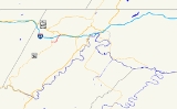
Maryland Route 55 is a state highway
in the U.S. state
of Maryland
. Known as Vale Summit Road, the state highway runs 2.53 miles (4.1 km) from MD 36
in Vale Summit
north to U.S. Route 40 Alternate (US 40 Alternate) in Clarysville
. MD 55 connects the La Vale
area with Midland
in the upper Georges Creek Valley
in northwestern Allegany County
. MD 55 was paved from Clarysville to Vale Summit around 1921 and extended south to Midland in the late 1930s. The state highway was truncated at Vale Summit when MD 36 took over part of the highway for a new alignment in the early 1970s.
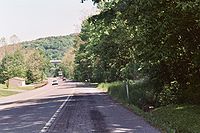 MD 55 begins at an intersection with MD 36 (New Georges Creek Road) in Vale Summit. The two-lane highway descends from Vale Summit into the valley of Braddock Run on its way to Clarysville. The state highway starts by heading east through a residential area of Vale Summit. As MD 55 passes the Vale Summit United Methodist Church, which dates back to 1889, the state highway curves to the north and passes by the residential settlements of Loartown and Montel. The state highway descends into Spruce Hollow and passes under Interstate 68
and US 40
(National Freeway) with no access before arriving in Clarysville. MD 55 intersects Clarysville Road, the original alignment of US 40, and passes the site of the Clarysville Inn
, a historic inn built in 1807 that was destroyed by a fire in 1999, before reaching its northern terminus at US 40 Alternate (National Pike) in Clarysville.
.
{|class=wikitable
!Location
!Mile
!Destinations
!Notes
|-
|Vale Summit
|0.00
|
|Southern terminus
|-
|Clarysville
|2.53
|
|Northern terminus
State highway
State highway, state road or state route can refer to one of three related concepts, two of them related to a state or provincial government in a country that is divided into states or provinces :#A...
in the U.S. state
U.S. state
A U.S. state is any one of the 50 federated states of the United States of America that share sovereignty with the federal government. Because of this shared sovereignty, an American is a citizen both of the federal entity and of his or her state of domicile. Four states use the official title of...
of Maryland
Maryland
Maryland is a U.S. state located in the Mid Atlantic region of the United States, bordering Virginia, West Virginia, and the District of Columbia to its south and west; Pennsylvania to its north; and Delaware to its east...
. Known as Vale Summit Road, the state highway runs 2.53 miles (4.1 km) from MD 36
Maryland Route 36
Maryland Route 36 is a state highway located in Allegany County, Maryland, United States. MD 36's southern terminus is at the WV 46 bridge in Westernport and its northern terminus at U.S. Route 40 Alternate near Cumberland...
in Vale Summit
Vale Summit, Maryland
Vale Summit is an unincorporated community in Allegany County, Maryland, United States.Local lore indicates that the community was so named in the mid 19th century, founded by the local population of coal miners. Previously, however, it was locally known as "Pompey Smash", the origin of which is...
north to U.S. Route 40 Alternate (US 40 Alternate) in Clarysville
Clarysville, Maryland
Clarysville is an unincorporated town in Allegany County, Maryland, USA. It is located along U.S. Route 40 Alternate, at its intersection with Maryland Route 55. Clarysville was known around the region for the Clarysville Inn, a historic building which stood in Clarysville from 1807 until it burned...
. MD 55 connects the La Vale
La Vale, Maryland
La Vale is a census-designated place in Allegany County, Maryland, United States. It is part of the 'Cumberland, MD-WV Metropolitan Statistical Area'...
area with Midland
Midland, Maryland
Midland is a town in Allegany County, Maryland, United States, located along the Georges Creek Valley. It is part of the Cumberland, MD-WV Metropolitan Statistical Area. The population was 473 at the 2000 census....
in the upper Georges Creek Valley
Georges Creek Valley
Georges Creek Valley is located in Allegany County, Maryland along the George's Creek. The valley is rich in wide veins of coal, known historically as the "The Big Vein." Coal was once extracted by deep mines but is only mined today through surface mining...
in northwestern Allegany County
Allegany County, Maryland
Allegany County is a county located in the northwestern part of the US state of Maryland. It is part of the Cumberland, MD-WV Metropolitan Statistical Area. As of 2010, the population was 75,087. Its county seat is Cumberland...
. MD 55 was paved from Clarysville to Vale Summit around 1921 and extended south to Midland in the late 1930s. The state highway was truncated at Vale Summit when MD 36 took over part of the highway for a new alignment in the early 1970s.
Route description
Interstate 68
Interstate 68 is a Interstate highway in the U.S. states of West Virginia and Maryland, connecting in Morgantown to in Hancock. is also Corridor E of the Appalachian Development Highway System. From 1965 until the freeway's construction was completed in 1991, it was designated as...
and US 40
U.S. Route 40 in Maryland
U.S. Route 40 in the U.S. state of Maryland runs from western Maryland to Cecil County in the state's northeastern corner. With a total length of over , it is the longest numbered highway in Maryland. Almost half of the road overlaps with Interstate 68 or Interstate 70, while the old alignment...
(National Freeway) with no access before arriving in Clarysville. MD 55 intersects Clarysville Road, the original alignment of US 40, and passes the site of the Clarysville Inn
Inns on the National Road
The Inns on the National Road is a national historic district near Cumberland, Allegany County, Maryland. It originally consisted of 11 Maryland inns on the National Road and located in Allegany and Garrett counties...
, a historic inn built in 1807 that was destroyed by a fire in 1999, before reaching its northern terminus at US 40 Alternate (National Pike) in Clarysville.
History
MD 55 was paved from Clarysville to Vale Summit by 1921. The Vale Summit–Midland segment of the highway was constructed around 1938. When US 40 was relocated in Clarysville around 1950, MD 55 was extended north a short distance to meet the new alignment. MD 55 itself was rebuilt and widened from Clarysville to Vale Summit in 1952 and from there to Midland in 1954. As part of MD 36's relocation between Midland and Frostburg, MD 36 took over the section of MD 55 between Midland and Vale Summit in 1972, leaving MD 55 at its present length.Junction list
The entire route is in Allegany CountyAllegany County, Maryland
Allegany County is a county located in the northwestern part of the US state of Maryland. It is part of the Cumberland, MD-WV Metropolitan Statistical Area. As of 2010, the population was 75,087. Its county seat is Cumberland...
.
{|class=wikitable
!Location
!Mile
!Destinations
!Notes
|-
|Vale Summit
Vale Summit, Maryland
Vale Summit is an unincorporated community in Allegany County, Maryland, United States.Local lore indicates that the community was so named in the mid 19th century, founded by the local population of coal miners. Previously, however, it was locally known as "Pompey Smash", the origin of which is...
|0.00
|
|Southern terminus
|-
|Clarysville
Clarysville, Maryland
Clarysville is an unincorporated town in Allegany County, Maryland, USA. It is located along U.S. Route 40 Alternate, at its intersection with Maryland Route 55. Clarysville was known around the region for the Clarysville Inn, a historic building which stood in Clarysville from 1807 until it burned...
|2.53
|
|Northern terminus