
Maryland Route 658
Encyclopedia
Maryland Route 658 is an unsigned
state highway
in the U.S. state
of Maryland
. The state highway runs 0.84 miles (1.4 km) from MD 53
north to U.S. Route 40 Alternate (US 40 Alternate) within La Vale
. MD 658 is part of US 220 Truck, which provides access from Interstate 68
(I-68) west of La Vale to US 220
south for trucks due to a truck prohibition on the eastbound exit ramp for I-68's interchange with US 220. MD 658 was originally assigned to Campground Road in the late 1930s. The state highway was extended south over Vocke Road in the late 1940s.
and the District 6 offices of the Maryland State Highway Administration
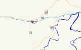
before intersecting a segment of Braddock Road, which is unsigned MD 949. The state highway intersects entrance and exit ramps from Exit 40 of eastbound I-68 and US 40
(National Freeway). MD 658 passes under the freeway and meets an exit ramp from westbound I-68 and the western terminus of MD 49
(Braddock Road) at the next intersection, where the highway's name changes to Campground Road. The state highway turns north, crossing Braddock Run and reducing to a four-lane undivided highway before reaching its northern terminus at US 40 Alternate (National Pike).
in Allegany County
.
{| class=wikitable
!Mile
!Destinations
!Notes
|-
|0.00
|
|Southern terminus; US 220 Truck turns south onto MD 53
|-
|0.51
|
|I-68 Exit 40; Eastbound I-68 exit and entrance; US 220 Truck begins at this intersection
|-
|0.63
|
|West leg of intersection is exit ramp from I-68 west
|-
|0.84
|
|Northern terminus
Unsigned highway
An unsigned highway is a highway that has been assigned a route number, but does not bear conventional road markings that would normally be used to identify the route with that number...
state highway
State highway
State highway, state road or state route can refer to one of three related concepts, two of them related to a state or provincial government in a country that is divided into states or provinces :#A...
in the U.S. state
U.S. state
A U.S. state is any one of the 50 federated states of the United States of America that share sovereignty with the federal government. Because of this shared sovereignty, an American is a citizen both of the federal entity and of his or her state of domicile. Four states use the official title of...
of Maryland
Maryland
Maryland is a U.S. state located in the Mid Atlantic region of the United States, bordering Virginia, West Virginia, and the District of Columbia to its south and west; Pennsylvania to its north; and Delaware to its east...
. The state highway runs 0.84 miles (1.4 km) from MD 53
Maryland Route 53
Maryland Route 53 is a state highway in the U.S. state of Maryland. Known as Winchester Road, the state highway runs from U.S. Route 220 in Cresaptown north to US 40 Alternate in La Vale...
north to U.S. Route 40 Alternate (US 40 Alternate) within La Vale
La Vale, Maryland
La Vale is a census-designated place in Allegany County, Maryland, United States. It is part of the 'Cumberland, MD-WV Metropolitan Statistical Area'...
. MD 658 is part of US 220 Truck, which provides access from Interstate 68
Interstate 68
Interstate 68 is a Interstate highway in the U.S. states of West Virginia and Maryland, connecting in Morgantown to in Hancock. is also Corridor E of the Appalachian Development Highway System. From 1965 until the freeway's construction was completed in 1991, it was designated as...
(I-68) west of La Vale to US 220
U.S. Route 220 in Maryland
U.S. Route 220 is a part in the U.S. Highway System that runs from Rockingham, North Carolina to Waverly, New York. In Maryland, the federal highway runs from the West Virginia state line at the Potomac River in McCoole north to the Pennsylvania state line in Dickens...
south for trucks due to a truck prohibition on the eastbound exit ramp for I-68's interchange with US 220. MD 658 was originally assigned to Campground Road in the late 1930s. The state highway was extended south over Vocke Road in the late 1940s.
Route description
MD 658 begins at an intersection with MD 53 (Winchester Road) in La Vale. The state highway heads northeast as Vocke Road, a four-lane divided highway. MD 658 passes the Country Club MallCountry Club Mall
Country Club Mall is a shopping mall located in La Vale, Maryland, a suburb of Cumberland, Maryland in Allegany County, Maryland. The mall has 47 retail units, as well as 5 vendor stands on the main concourse. The largest retailers in the mall are Wal-Mart, the Bon-Ton, Sears, and JCPenney...
and the District 6 offices of the Maryland State Highway Administration
Maryland State Highway Administration
The Maryland State Highway Administration is the state agency responsible for maintaining Maryland numbered highways outside of Baltimore City...
before intersecting a segment of Braddock Road, which is unsigned MD 949. The state highway intersects entrance and exit ramps from Exit 40 of eastbound I-68 and US 40
U.S. Route 40 in Maryland
U.S. Route 40 in the U.S. state of Maryland runs from western Maryland to Cecil County in the state's northeastern corner. With a total length of over , it is the longest numbered highway in Maryland. Almost half of the road overlaps with Interstate 68 or Interstate 70, while the old alignment...
(National Freeway). MD 658 passes under the freeway and meets an exit ramp from westbound I-68 and the western terminus of MD 49
Maryland Route 49
Maryland Route 49 is a state highway in the U.S. state of Maryland. Known as Braddock Road, the state highway runs from MD 658 in La Vale east to Greene Street in Cumberland. MD 49 is maintained by the Maryland State Highway Administration for on the west side of Haystack Mountain...
(Braddock Road) at the next intersection, where the highway's name changes to Campground Road. The state highway turns north, crossing Braddock Run and reducing to a four-lane undivided highway before reaching its northern terminus at US 40 Alternate (National Pike).
History
MD 658 was assigned to Campground Road as a connector between US 40 and MD 49 in 1939. The state highway was extended south along Vocke Road to MD 53 around 1948. MD 658 was expanded to a divided highway from MD 53 to MD 49 around 1972 in conjunction with the construction of I-68 through La Vale.Junction list
The entire route is in La ValeLa Vale, Maryland
La Vale is a census-designated place in Allegany County, Maryland, United States. It is part of the 'Cumberland, MD-WV Metropolitan Statistical Area'...
in Allegany County
Allegany County, Maryland
Allegany County is a county located in the northwestern part of the US state of Maryland. It is part of the Cumberland, MD-WV Metropolitan Statistical Area. As of 2010, the population was 75,087. Its county seat is Cumberland...
.
{| class=wikitable
!Mile
!Destinations
!Notes
|-
|0.00
|
|Southern terminus; US 220 Truck turns south onto MD 53
|-
|0.51
|
|I-68 Exit 40; Eastbound I-68 exit and entrance; US 220 Truck begins at this intersection
|-
|0.63
|
|West leg of intersection is exit ramp from I-68 west
|-
|0.84
|
|Northern terminus