
Pennsylvania Route 669
Encyclopedia
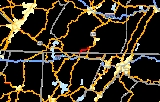
Pennsylvania Route 669 (designated by the Pennsylvania Department of Transportation
as SR 669) is a 5.8 miles (9.3 km) long state highway
located in Somerset
county in Pennsylvania
. The southern terminus is at the Maryland
state line in Elk Lick Township
, where Maryland Route 669
and Springs Road cross the state line from U.S. Route 40 Alternate. The route heads along Springs Road and Ord Street through its rural and residential alignment. The northern terminus is at the intersection with U.S. Route 219
(Grant Street) in the borough of Salisbury
. The route was designated in 1963, and a renumbered Route 417 was soon matched up over the state line in Maryland.
in the community of Elk Lick Township, Pennsylvania
. The route progresses northward as Springs Road, passing through the rural regions of southern central Pennsylvania. Around the intersection with Ash Hill Road, the highway passes a light demographic of homes, but as Route 669 turns to the northwest at Upper Springs Road, begins to grow. The highway enters the community of Springs, Pennsylvania
, a portion of Elk Lick Township. Through Springs, Route 669 becomes surrounded by light forestry and residences, turning to the north once again at an intersection with Shoemaker Hill Road. For a short stretch after Shoemaker Hill Road, Route 669 becomes a rural highway, crossing through fields. However, this changes as the highway enters the community of Niverton. In Niverton, Route 669 passes some residences and a large lumber yard, but after curving eastward at Fisher Road and Savage Road, Springs Road and Route 669 return to their rural nature.
Route 669 westward does continue eastward through Niverton, but soon turns southeastward into a short residential portion surrounded by fields. At the intersection with Oak Dale Road, the highway begins a curve back to the northeast, entering the small community of Sylvan Lane soon after. In Sylvan Lane, Route 669 continues its small community nature, and continues northeastward through rural Somerset County before entering Salisbury
. After making a large curve to the north, the highway continues through rural Salisbury, paralleling the nearby river. Route 669 enters West Salisbury and intersects with Saint Paul Road, where the highway turns eastward on a bridge across the river. After crossing the river, Route 669 becomes known as Ord Street and enters downtown Salisbury. There, the highway passes several residences before intersecting and terminating at an intersection with U.S. Route 219
(Grant Street). Ord Street continues eastward until changing names to Engles Mills Road soon after.
. The one over the Casselman River
in Salisbury was constructed in 1922 and handles an average of 1,469 vehicles per day. The second bridge, the one over Tub Mill Run in West Salisbury is in similar shape, but constructed three years later.
Pennsylvania Department of Transportation
The Pennsylvania Department of Transportation oversees transportation issues in the Commonwealth of Pennsylvania. The administrator of PennDOT is the Pennsylvania Secretary of Transportation, currently Barry Schoch Presently, PennDOT supports over of state roads and highways, about 25,000...
as SR 669) is a 5.8 miles (9.3 km) long state highway
State highway
State highway, state road or state route can refer to one of three related concepts, two of them related to a state or provincial government in a country that is divided into states or provinces :#A...
located in Somerset
Somerset County, Pennsylvania
Somerset County is a county located in the state of Pennsylvania. As of 2010, the population was 77,742. Somerset County was created on April 17, 1795, from part of Bedford County and named for Somerset, United Kingdom. Its county seat is Somerset. It is part of the Johnstown, Pennsylvania,...
county in Pennsylvania
Pennsylvania
The Commonwealth of Pennsylvania is a U.S. state that is located in the Northeastern and Mid-Atlantic regions of the United States. The state borders Delaware and Maryland to the south, West Virginia to the southwest, Ohio to the west, New York and Ontario, Canada, to the north, and New Jersey to...
. The southern terminus is at the Maryland
Maryland
Maryland is a U.S. state located in the Mid Atlantic region of the United States, bordering Virginia, West Virginia, and the District of Columbia to its south and west; Pennsylvania to its north; and Delaware to its east...
state line in Elk Lick Township
Elk Lick Township, Pennsylvania
Elk Lick Township is a township in Somerset County, Pennsylvania, United States. The population was 2,293 at the 2000 census. Located within the township is Mount Davis, the highest point in Pennsylvania at 3,213 ft...
, where Maryland Route 669
Maryland Route 669
Maryland Route 669 is a state highway in the U.S. state of Maryland. Known as Springs Road, the state highway runs from U.S. Route 40 Alternate in Grantsville north to the Pennsylvania state line, where the highway continues as Pennsylvania Route 669...
and Springs Road cross the state line from U.S. Route 40 Alternate. The route heads along Springs Road and Ord Street through its rural and residential alignment. The northern terminus is at the intersection with U.S. Route 219
U.S. Route 219 in Pennsylvania
From near Grantsville, Maryland north to Ebensburg, Pennsylvania, U.S. Route 219 is Corridor N of the Appalachian Development Highway System. From Somerset, Pennsylvania to just south of Carrolltown, Pennsylvania, US 219 is a limited-access highway...
(Grant Street) in the borough of Salisbury
Salisbury, Pennsylvania
Salisbury is a borough in Somerset County, Pennsylvania, United States. The population was 878 at the 2000 census. It is part of the Johnstown, Pennsylvania Metropolitan Statistical Area.-History:...
. The route was designated in 1963, and a renumbered Route 417 was soon matched up over the state line in Maryland.
Route description
Route 669 begins at the state line as a continuation of Maryland Route 669Maryland Route 669
Maryland Route 669 is a state highway in the U.S. state of Maryland. Known as Springs Road, the state highway runs from U.S. Route 40 Alternate in Grantsville north to the Pennsylvania state line, where the highway continues as Pennsylvania Route 669...
in the community of Elk Lick Township, Pennsylvania
Elk Lick Township, Pennsylvania
Elk Lick Township is a township in Somerset County, Pennsylvania, United States. The population was 2,293 at the 2000 census. Located within the township is Mount Davis, the highest point in Pennsylvania at 3,213 ft...
. The route progresses northward as Springs Road, passing through the rural regions of southern central Pennsylvania. Around the intersection with Ash Hill Road, the highway passes a light demographic of homes, but as Route 669 turns to the northwest at Upper Springs Road, begins to grow. The highway enters the community of Springs, Pennsylvania
Springs, Pennsylvania
Springs is an unincorporated community in Elk Lick Township, Somerset County, Pennsylvania, United States. Springs is known for its Spring Folk Festival, which occurs annually in October, its museum and its farmers' market. It is part of the Johnstown, Pennsylvania Metropolitan Statistical...
, a portion of Elk Lick Township. Through Springs, Route 669 becomes surrounded by light forestry and residences, turning to the north once again at an intersection with Shoemaker Hill Road. For a short stretch after Shoemaker Hill Road, Route 669 becomes a rural highway, crossing through fields. However, this changes as the highway enters the community of Niverton. In Niverton, Route 669 passes some residences and a large lumber yard, but after curving eastward at Fisher Road and Savage Road, Springs Road and Route 669 return to their rural nature.
Route 669 westward does continue eastward through Niverton, but soon turns southeastward into a short residential portion surrounded by fields. At the intersection with Oak Dale Road, the highway begins a curve back to the northeast, entering the small community of Sylvan Lane soon after. In Sylvan Lane, Route 669 continues its small community nature, and continues northeastward through rural Somerset County before entering Salisbury
Salisbury, Pennsylvania
Salisbury is a borough in Somerset County, Pennsylvania, United States. The population was 878 at the 2000 census. It is part of the Johnstown, Pennsylvania Metropolitan Statistical Area.-History:...
. After making a large curve to the north, the highway continues through rural Salisbury, paralleling the nearby river. Route 669 enters West Salisbury and intersects with Saint Paul Road, where the highway turns eastward on a bridge across the river. After crossing the river, Route 669 becomes known as Ord Street and enters downtown Salisbury. There, the highway passes several residences before intersecting and terminating at an intersection with U.S. Route 219
U.S. Route 219 in Pennsylvania
From near Grantsville, Maryland north to Ebensburg, Pennsylvania, U.S. Route 219 is Corridor N of the Appalachian Development Highway System. From Somerset, Pennsylvania to just south of Carrolltown, Pennsylvania, US 219 is a limited-access highway...
(Grant Street). Ord Street continues eastward until changing names to Engles Mills Road soon after.
History
During the 1930s, the Maryland Department of Highways began the modernization of Springs Road on their side of the border to basic state highway standards. Route 669 was first designated along its current alignment in 1963 from the Maryland state line to the borough of Salisbury and the intersection with U.S. Route 219. By 1968, the Maryland State Highway Administration had renumbered Maryland Route 417, which ran southward from Route 669 as Maryland Route 669. The two bridges Route 669 uses to cross waterways in Salisbury and West Salisbury have both been deemed structurally deficient by the United States Department of TransportationUnited States Department of Transportation
The United States Department of Transportation is a federal Cabinet department of the United States government concerned with transportation. It was established by an act of Congress on October 15, 1966, and began operation on April 1, 1967...
. The one over the Casselman River
Casselman River
The Casselman River is a tributary of the Youghiogheny River in western Maryland and Pennsylvania in the United States.The Casselman River rises atop the plateau of western Maryland and then follows a great arc across the Laurel Highlands of Somerset County, Pennsylvania to the appropriately named...
in Salisbury was constructed in 1922 and handles an average of 1,469 vehicles per day. The second bridge, the one over Tub Mill Run in West Salisbury is in similar shape, but constructed three years later.