

U.S. Route 1 in New York
Encyclopedia
U.S. Route 1 is a part of the U.S. Highway System that runs from Key West, Florida
, to the Canada – United States border at Fort Kent, Maine
. In the U.S. state
of New York
, US 1 extends 21.69 miles (34.91 km) from the George Washington Bridge
in Manhattan
to the Connecticut
state line at Port Chester
. It closely parallels Interstate 95
for much of its course, and does not serve as a major trunk route within the state. It does not overlap
with any other roads besides I-95 and (briefly) US 9, and few other state highways intersect it.
It passes through a variety of different terrain within the city and Westchester County
, from the Cross Bronx Expressway to several important surface roads in the northwestern Bronx and then the main street of the Westchester suburbs along Long Island Sound
. In many of the latter communities, it begins to intermittently follows the route of the historic Boston Post Road
, and often still carries that name.
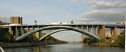
on the George Washington Bridge
together with US 9 and Interstate 95
. The concurrency between US 1 and US 9
that began at Woodbridge 31 miles (50 km) to the south ends at the first exit, when Route 9 splits to the north to follow Broadway
. The expressway continues another mile, crossing under several buildings in short tunnels, before crossing the Harlem River
via the Alexander Hamilton Bridge
into the Bronx. It is bookended by an exit to the Harlem River Drive
on the west and the Major Deegan Expressway
(Interstate 87) on the east.
 The busy highway, now known as the Cross Bronx Expressway, continues another 2 miles (3 km) until US 1 leaves it at Webster Avenue
, one of the Bronx's longest streets, in the Tremont
section of the borough, on a northerly heading. A mile and a half beyond the Cross Bronx, Route 1 turns right (east) onto Fordham Road
, near the eponymous university
. At this busy transportation hub, the road also crosses the Metro-North Railroad
at the Fordham station
.
Route 1's eastward heading trends to the south as it enters Bronx Park
a mile to the east, after a complex junction with Southern Boulevard. In the park, it crosses the Bronx River
, where it trends back to the north again, and has a full cloverleaf interchange
with the Bronx River Parkway
. Immediately following that, it turns north on Boston Road, the first section of the Boston Post Road
it follows into Connecticut. This slants northeast across the eastern outskirts of Williamsbridge
past Gun Hill Road into Eastchester
, where it starts to veer eastward again, to a route more closely parallel with I-95. At Provost Avenue, NY 22
, New York's longest north–south route, starts a journey to the Canadian border.
The Hutchinson River is next. Just after Ropes Avenue to the south, it leaves New York City.
, the Hutchinson River Parkway
crosses over, with access available in both directions. Now Boston Post Road, it crosses the village and, another mile to the northeast, has another interchange at I-95 (now the New England Thruway) just after entering New Rochelle
at Pelham Country Club. Just after that it crosses under Amtrak
's Northeast Corridor
.
A mile past that junction, in New Rochelle's busy downtown, US 1 divides, with northbound traffic staying on Main Street while Huguenot Street takes southbound drivers. The roads rejoin after another mile, at Pratt Street, as the surrounding neighborhood becomes more residential. New Rochelle gives way to Larchmont
after another mile, and returns to being Boston Post Road. A mile and a half later, after passing through downtown, NY 125
, a short route to White Plains
, leaves to the north at Weaver Street.
After another few blocks, Route 1 comes to the Mamaroneck
town line. Here it comes closer to Long Island Sound
when it passes Harbor Island Park a mile from the municipal boundary, and then enters the village
at Mamaroneck Avenue. A mile past that junction and downtown, NY 127
, also bound for White Plains, forks left at Keeler Avenue as 1 itself begins to trend more to the east into Rye
, passing Rye Neck High School
at the town line.
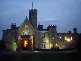 To the right of the wooded area to the north is the Boston Post Road Historic District, a National Historic Landmark
characterized by mansions and homes that have remained unchanged since before the Civil War including the 1838 Peter Augustus Jay House
, Lounsberry and Whitby Castle. The road begins to head more to the north after passing it and Rye Golf Club, to its intersection with Playland
Parkway, which leads to the popular amusement park
, Rye's other National Historic Landmark.
One mile past this junction, US 1 crosses downtown Rye, where NY 120
forks off to the north at Purchase Street, and then passes through the junction that marks the eastern terminus of Interstate 287, the Cross Westchester Expressway, crossing it and I-95 again in the process, with access to both. Immediately afterward it enters Port Chester
, its last community in New York.
It curves a bit toward the east here, crossing the railroad tracks again after an industrial area, then turning left on South Main Street to follow a more northern route through the working-class city's busy downtown, where NY 120A
touches at Westchester and King streets to eventually follow the New York-Connecticut border back to its parent route.
Now North Main Street, Route 1 continues through downtown Port Chester to cross under the tracks again. Traffic lessens here as the neighborhood grows less commercial, and a half-mile later, at Putnam Avenue, the road crosses the Byram River
into Greenwich, Connecticut
at the beginning of a brief split (southbound traffic enters New York on Hillside Avenue).
, an early colonial highway between New York City
and Boston originally laid out in 1673 for transporting mail and later utilized for stage coach travel. The old Boston Post Road began in Lower Manhattan
and went north across the length of Manhattan. It crossed into the mainland on Kingsbridge
, then continued through a largely abandoned road to Williamsbridge
, then across the northern part of the Bronx along Bussing Avenue. It then continued into Westchester County along Kingsbridge Road, South Columbus Avenue, Colonial Avenue, and Kings Highway to present US 1. From there the old Boston Post Road roughly followed modern US 1 into Connecticut
. By 1797, a new bridge over the Harlem River, approximately at the site of the Third Avenue Bridge, had been constructed. This significantly shortened the route out of Manhattan and this new alignment became the preferred route. The new alignment used Third Avenue and Boston Road in the Bronx, then continued along modern US 1 through Westchester County.
In 1800, the Westchester Turnpike company was chartered to build and maintain a toll road between New York City and Connecticut. The company straightened out the old Boston Post Road in Westchester County to more or less the modern alignment of US 1. By the middle of the 19th century, most of the toll roads had been dissolved and the roads reverted to public management. In the beginning of the 20th century, the state highway system was established in New York and most of the main thoroughfares came under the control of the State Highway Department. Highways were first publicly marked with route numbers in 1924. The old Westchester Turnpike alignment was designated as NY 1, which matched the route number across the Connecticut state line. NY 1 ended at the New York city limits since roads in the city were not under the control of the State Highway Department.
In 1926, the U.S. Highway system was established. U.S. Route 1 in New York was designated from Jersey City, New Jersey
, through New York City and lower Westchester, to Greenwich, Connecticut
. Old NY 1 was incorporated into the new US 1. However, because New York city did not post route numbers, US 1 ended at the 42nd Street Ferry landing in Weehawken
(where the old Lincoln Highway
crossed into the city) and resumed again at the Bronx-Westchester boundary. By 1928, the Holland Tunnel
opened and the end of US 1 on the New Jersey side was moved there.
For several years, the Automobile Club of New York had been lobbying New York City to sign state highways within the city, including US 1. Their proposal was to sign US 1 from the Holland Tunnel, then along Houston Street and Second Avenue
, then crossing the Harlem River along the Willis Avenue Bridge
, then via Southern Boulevard, West Farms Road, and Boston Road. In December 1934, New York City finally agreed to sign routes within the city. By this time, the new George Washington Bridge
had opened and it was decided that US 1 and US 9 would be routed through there. The old proposed US 1 alignment through Manhattan became NY 1A
. When first signed in New York City, US 1 utilized 181st Street, then crossed the Harlem River on the Washington Bridge
, and then continued on University Avenue and Fordham Road before continuing on modern US 1. In 1977, US 1 was moved to Webster Avenue and the Cross Bronx Expressway, crossing the Harlem River using the Alexander Hamilton Bridge
.
|rowspan=4|New York
|rowspan=12|New York City
|0.00
|
|New Jersey
state line on the George Washington Bridge
|-
|0.55
|
|Exit 1A
|-
|0.84
|
|Northern terminus of US 1 / US 9 overlap; access via exit 1A
|-
|1.16
|
|Exit 1B
|-
|rowspan=8|Bronx
|1.45
|
|Exit 1C
|-
|2.03
|Jerome Avenue
|Exit 2A
|-
|2.66
|
|Exit 2B; northern terminus of I-95 / US 1 overlap
|-
|4.09
|Fordham Road
|-
|5.08
|
|-
|5.39
|
|-
|6.78
|Gun Hill Road
|-
|8.42
|
|-
|rowspan=10|Westchester
|Pelham Manor
|9.17
|
|-
|New Rochelle
|10.44
|
|-
|Town of Mamaroneck
|14.05
|
|Just outside Larchmont
village line
|-
|Village of Mamaroneck
|15.88
|
|-
|rowspan=4|Rye
|18.05
|Playland Parkway
|-
|18.97
|
|-
|19.42
|
|-
|19.77
|
|Rye city line
|-
|rowspan=2|Port Chester
|20.77
|Westchester Avenue (CR 112)
|Access to NY 120A
|-
|21.69
|
|Connecticut
state line
Key West, Florida
Key West is a city in Monroe County, Florida, United States. The city encompasses the island of Key West, the part of Stock Island north of U.S. 1 , Sigsbee Park , Fleming Key , and Sunset Key...
, to the Canada – United States border at Fort Kent, Maine
Fort Kent, Maine
Fort Kent is a town in Aroostook County, Maine, United States. The population was 4,097 in the 2010 census. Fort Kent is home to an Olympic biathlete training center, an annual CAN-AM dogsled race, and the Fort Kent Blockhouse, built in reaction to the Aroostook War and in modern times designated...
. In the U.S. state
U.S. state
A U.S. state is any one of the 50 federated states of the United States of America that share sovereignty with the federal government. Because of this shared sovereignty, an American is a citizen both of the federal entity and of his or her state of domicile. Four states use the official title of...
of New York
New York
New York is a state in the Northeastern region of the United States. It is the nation's third most populous state. New York is bordered by New Jersey and Pennsylvania to the south, and by Connecticut, Massachusetts and Vermont to the east...
, US 1 extends 21.69 miles (34.91 km) from the George Washington Bridge
George Washington Bridge
The George Washington Bridge is a suspension bridge spanning the Hudson River, connecting the Washington Heights neighborhood in the borough of Manhattan in New York City to Fort Lee, Bergen County, New Jersey. Interstate 95 and U.S. Route 1/9 cross the river via the bridge. U.S...
in Manhattan
Manhattan
Manhattan is the oldest and the most densely populated of the five boroughs of New York City. Located primarily on the island of Manhattan at the mouth of the Hudson River, the boundaries of the borough are identical to those of New York County, an original county of the state of New York...
to the Connecticut
Connecticut
Connecticut is a state in the New England region of the northeastern United States. It is bordered by Rhode Island to the east, Massachusetts to the north, and the state of New York to the west and the south .Connecticut is named for the Connecticut River, the major U.S. river that approximately...
state line at Port Chester
Port Chester, New York
Port Chester is a village in Westchester County, New York, United States. The village is part of the town of Rye. As of the 2010 census, Port Chester had a population of 28,967...
. It closely parallels Interstate 95
Interstate 95 in New York
Interstate 95 is a part of the Interstate Highway System that runs from Miami, Florida, to the Canada – United States border near Houlton, Maine. In the U.S. state of New York, I-95 extends from the George Washington Bridge in New York City to the Connecticut state line at Port Chester...
for much of its course, and does not serve as a major trunk route within the state. It does not overlap
Concurrency (road)
A concurrency, overlap, or coincidence in a road network is an instance of one physical road bearing two or more different highway, motorway, or other route numbers...
with any other roads besides I-95 and (briefly) US 9, and few other state highways intersect it.
It passes through a variety of different terrain within the city and Westchester County
Westchester County, New York
Westchester County is a county located in the U.S. state of New York. Westchester covers an area of and has a population of 949,113 according to the 2010 Census, residing in 45 municipalities...
, from the Cross Bronx Expressway to several important surface roads in the northwestern Bronx and then the main street of the Westchester suburbs along Long Island Sound
Long Island Sound
Long Island Sound is an estuary of the Atlantic Ocean, located in the United States between Connecticut to the north and Long Island, New York to the south. The mouth of the Connecticut River at Old Saybrook, Connecticut, empties into the sound. On its western end the sound is bounded by the Bronx...
. In many of the latter communities, it begins to intermittently follows the route of the historic Boston Post Road
Boston Post Road
The Boston Post Road was a system of mail-delivery routes between New York City and Boston, Massachusetts that evolved into the first major highways in the United States.The three major alignments were the Lower Post Road The Boston Post Road was a system of mail-delivery routes between New York...
, and often still carries that name.
Route description
Route 1 enters New York concurrent with I-95 and US 9, but returns to a solo surface route a short distance into the Bronx. It remains a busy urban and suburban artery all the way to Connecticut, often four lanes wide and serving as the main street of many of the communities it passes through once it leaves the city. I-95 returns to close proximity in the suburbs as well, and the two roads intersect twice.New York City
US 1 enters ManhattanManhattan
Manhattan is the oldest and the most densely populated of the five boroughs of New York City. Located primarily on the island of Manhattan at the mouth of the Hudson River, the boundaries of the borough are identical to those of New York County, an original county of the state of New York...
on the George Washington Bridge
George Washington Bridge
The George Washington Bridge is a suspension bridge spanning the Hudson River, connecting the Washington Heights neighborhood in the borough of Manhattan in New York City to Fort Lee, Bergen County, New Jersey. Interstate 95 and U.S. Route 1/9 cross the river via the bridge. U.S...
together with US 9 and Interstate 95
Interstate 95 in New York
Interstate 95 is a part of the Interstate Highway System that runs from Miami, Florida, to the Canada – United States border near Houlton, Maine. In the U.S. state of New York, I-95 extends from the George Washington Bridge in New York City to the Connecticut state line at Port Chester...
. The concurrency between US 1 and US 9
U.S. Route 1/9
U.S. Route 9 is a U.S. highway in the northeast United States, running from Laurel, Delaware north to the Canadian border near Champlain, New York...
that began at Woodbridge 31 miles (50 km) to the south ends at the first exit, when Route 9 splits to the north to follow Broadway
Broadway (New York City)
Broadway is a prominent avenue in New York City, United States, which runs through the full length of the borough of Manhattan and continues northward through the Bronx borough before terminating in Westchester County, New York. It is the oldest north–south main thoroughfare in the city, dating to...
. The expressway continues another mile, crossing under several buildings in short tunnels, before crossing the Harlem River
Harlem River
The Harlem River is a navigable tidal strait in New York City, USA that flows 8 miles between the Hudson River and the East River, separating the boroughs of Manhattan and the Bronx...
via the Alexander Hamilton Bridge
Alexander Hamilton Bridge
The Alexander Hamilton Bridge carries eight lanes of traffic over the Harlem River in New York City between the boroughs of Manhattan and the Bronx, connecting the Trans-Manhattan Expressway in the Washington Heights section of Manhattan and the Cross-Bronx Expressway, as part of Interstate 95...
into the Bronx. It is bookended by an exit to the Harlem River Drive
Harlem River Drive
The Harlem River Drive is a north–south parkway in the New York City borough of Manhattan. It runs along the west bank of the Harlem River from the Triborough Bridge in East Harlem to 10th Avenue in Inwood, where the parkway continues north as Dyckman Street. The portion of the Harlem River Drive...
on the west and the Major Deegan Expressway
Major Deegan Expressway
The Major Deegan Expressway is a north–south expressway in the New York City borough of the Bronx...
(Interstate 87) on the east.
Webster Avenue
Webster Avenue is one of the longest thoroughfares in the Bronx. It stretches for 5.8 miles from Melrose to Woodlawn . The road starts at an intersection with Melrose Avenue, East 165th Street, Brook Avenue and Park Avenue in Melrose, ending at Nereid Avenue and East 240th Street in the town of...
, one of the Bronx's longest streets, in the Tremont
Tremont, Bronx
Tremont is a low income residential neighborhood geographically located in the west Bronx, New York City. The neighborhood is part of Bronx Community Board 5. Its boundaries, starting from the north and moving clockwise are: East 183rd Street to the north, Webster Avenue to the east, the...
section of the borough, on a northerly heading. A mile and a half beyond the Cross Bronx, Route 1 turns right (east) onto Fordham Road
Fordham Road
Fordham Road is a major street in The Bronx borough of New York City. It runs east-west from the Harlem River to Bronx Park.This street runs through the neighborhood of University Heights, divides Fordham from Fordham-Bedford and finally runs along the northern border of Belmont...
, near the eponymous university
Fordham University
Fordham University is a private, nonprofit, coeducational research university in the United States, with three campuses in and around New York City. It was founded by the Roman Catholic Diocese of New York in 1841 as St...
. At this busy transportation hub, the road also crosses the Metro-North Railroad
Metro-North Railroad
The Metro-North Commuter Railroad , trading as MTA Metro-North Railroad, or, more commonly, Metro-North, is a suburban commuter rail service that is run and managed by the Metropolitan Transportation Authority , an authority of New York State. It is the busiest commuter railroad in the United...
at the Fordham station
Fordham (Metro-North station)
The Fordham Metro-North Railroad station serves the residents of the Fordham neighborhood of the Bronx, New York via the Harlem Line and New Haven Line. It is the only Harlem Line stop in the Bronx that is an express station. It is 8.9 miles from Grand Central Terminal...
.
Route 1's eastward heading trends to the south as it enters Bronx Park
Bronx Park
Bronx Park, laid out along the Bronx River in the Bronx, New York, is the home of the New York Botanical Garden and the Bronx Zoo. Bicycle paths go northwest, north and east, along Mosholu Parkway, Bronx River Parkway and Pelham Parkway respectively...
a mile to the east, after a complex junction with Southern Boulevard. In the park, it crosses the Bronx River
Bronx River
The Bronx River, approximately long, flows through southeast New York in the United States. It is named after colonial settler Jonas Bronck. The Bronx River is the only fresh water river in New York City....
, where it trends back to the north again, and has a full cloverleaf interchange
Cloverleaf interchange
A cloverleaf interchange is a two-level interchange in which left turns, reverse direction in left-driving regions, are handled by ramp roads...
with the Bronx River Parkway
Bronx River Parkway
The Bronx River Parkway is a long parkway in downstate New York. It is named for the nearby Bronx River, which it parallels. The southern terminus of the parkway is at Story Avenue near Bruckner Expressway in the Bronx neighborhood of Soundview...
. Immediately following that, it turns north on Boston Road, the first section of the Boston Post Road
Boston Post Road
The Boston Post Road was a system of mail-delivery routes between New York City and Boston, Massachusetts that evolved into the first major highways in the United States.The three major alignments were the Lower Post Road The Boston Post Road was a system of mail-delivery routes between New York...
it follows into Connecticut. This slants northeast across the eastern outskirts of Williamsbridge
Williamsbridge, Bronx
Williamsbridge is a working class neighborhood geographically located in the northeast Bronx borough of New York City in the United States. The neighborhood is part of Bronx Community Board 12. Its boundaries, starting from the north and moving clockwise are: East 222nd Street to the north, Boston...
past Gun Hill Road into Eastchester
Eastchester, Bronx
Eastchester is a working class neighborhood in the northeast Bronx borough of New York City in the United States. The neighborhood is part of Bronx Community Board 12...
, where it starts to veer eastward again, to a route more closely parallel with I-95. At Provost Avenue, NY 22
New York State Route 22
New York State Route 22 is a north–south state highway in eastern New York in the United States. It runs parallel to the state's eastern edge from the outskirts of New York City to a short distance south of the Canadian border. At , it is the state's longest north–south route and...
, New York's longest north–south route, starts a journey to the Canadian border.
The Hutchinson River is next. Just after Ropes Avenue to the south, it leaves New York City.
Westchester County
One-quarter mile into the village of Pelham ManorPelham Manor, New York
Pelham Manor is a village located in Westchester County, New York, USA. As of the 2010 census, the village had a total population of 5,486. It is located in the town of Pelham.- Demographics :...
, the Hutchinson River Parkway
Hutchinson River Parkway
The Hutchinson River Parkway is a north–south parkway in southern New York, United States. It extends for from the massive Bruckner Interchange in the Throgs Neck section of the Bronx to the New York – Connecticut state line at Rye Brook...
crosses over, with access available in both directions. Now Boston Post Road, it crosses the village and, another mile to the northeast, has another interchange at I-95 (now the New England Thruway) just after entering New Rochelle
New Rochelle, New York
New Rochelle is a city in Westchester County, New York, United States, in the southeastern portion of the state.The town was settled by refugee Huguenots in 1688 who were fleeing persecution in France...
at Pelham Country Club. Just after that it crosses under Amtrak
Amtrak
The National Railroad Passenger Corporation, doing business as Amtrak , is a government-owned corporation that was organized on May 1, 1971, to provide intercity passenger train service in the United States. "Amtrak" is a portmanteau of the words "America" and "track". It is headquartered at Union...
's Northeast Corridor
Northeast Corridor
The Northeast Corridor is a fully electrified railway line owned primarily by Amtrak serving the Northeast megalopolis of the United States from Boston in the north, via New York to Washington, D.C. in the south, with branches serving other cities...
.
A mile past that junction, in New Rochelle's busy downtown, US 1 divides, with northbound traffic staying on Main Street while Huguenot Street takes southbound drivers. The roads rejoin after another mile, at Pratt Street, as the surrounding neighborhood becomes more residential. New Rochelle gives way to Larchmont
Larchmont, New York
Larchmont is a village in Westchester County, New York. The population was 5,864 at the 2010 census. It is located within the town of Mamaroneck, on the shore of Long Island Sound, northeast of Midtown Manhattan...
after another mile, and returns to being Boston Post Road. A mile and a half later, after passing through downtown, NY 125
New York State Route 125
New York State Route 125 is a long north–south state highway in Westchester County, New York. The route begins in The Town of Mamaroneck at U.S...
, a short route to White Plains
White Plains, New York
White Plains is a city and the county seat of Westchester County, New York, United States. It is located in south-central Westchester, about east of the Hudson River and northwest of Long Island Sound...
, leaves to the north at Weaver Street.
After another few blocks, Route 1 comes to the Mamaroneck
Mamaroneck (town), New York
Mamaroneck is a town in Westchester County, New York, United States. The population was 29,156 at the 2010 census. There are two villages contained within the town: Larchmont and the Village of Mamaroneck...
town line. Here it comes closer to Long Island Sound
Long Island Sound
Long Island Sound is an estuary of the Atlantic Ocean, located in the United States between Connecticut to the north and Long Island, New York to the south. The mouth of the Connecticut River at Old Saybrook, Connecticut, empties into the sound. On its western end the sound is bounded by the Bronx...
when it passes Harbor Island Park a mile from the municipal boundary, and then enters the village
Mamaroneck (village), New York
Mamaroneck is a village in Westchester County, New York, United States. The population was 18,929 at the 2010 census. It is located partially within the town of Mamaroneck and partially within the town of Rye. The portion in Rye is unofficially called "Rye Neck"...
at Mamaroneck Avenue. A mile past that junction and downtown, NY 127
New York State Route 127
New York State Route 127 is a long north–south state highway in Westchester County, New York, from the village of Mamaroneck to the city of White Plains, New York.-Route description:...
, also bound for White Plains, forks left at Keeler Avenue as 1 itself begins to trend more to the east into Rye
Rye (city), New York
Rye is a city in Westchester County, New York, United States. It is separate from the town of Rye, which is larger than the city. Rye city, formerly the village of Rye, was part of the town until 1942, when it received its charter as a city, the most recent to be issued in New York...
, passing Rye Neck High School
Rye Neck High School
Rye Neck High School is a public secondary school located in the Village of Mamaroneck, New York within the Town of Rye, New York. It is part of the Rye Neck Union Free School District and is connected to Rye Neck Middle School.-Notability:...
at the town line.
National Historic Landmark
A National Historic Landmark is a building, site, structure, object, or district, that is officially recognized by the United States government for its historical significance...
characterized by mansions and homes that have remained unchanged since before the Civil War including the 1838 Peter Augustus Jay House
1838 Peter Augustus Jay House
The 1838 Peter Augustus Jay House and surrounding Jay Property form the centerpiece of the National Historic Landmark Boston Post Road Historic District. This historic district is the surviving remnant of the Jay estate where New York State's only native born Founding Father, John Jay, grew up...
, Lounsberry and Whitby Castle. The road begins to head more to the north after passing it and Rye Golf Club, to its intersection with Playland
Playland (New York)
Playland, often called Rye Playland and also known as Playland Amusement Park, is an amusement park located in Rye, New York. Run by Westchester County, it is the only government owned-and-operated amusement park in the United States.-History:...
Parkway, which leads to the popular amusement park
Amusement park
thumb|Cinderella Castle in [[Magic Kingdom]], [[Disney World]]Amusement and theme parks are terms for a group of entertainment attractions and rides and other events in a location for the enjoyment of large numbers of people...
, Rye's other National Historic Landmark.
One mile past this junction, US 1 crosses downtown Rye, where NY 120
New York State Route 120
New York State Route 120 is a state highway in southern Westchester County, New York, United States. It begins in the city of Rye at an intersection with U.S. Route 1 and runs for about north to the hamlet of Millwood, where it ends at a junction with NY 100...
forks off to the north at Purchase Street, and then passes through the junction that marks the eastern terminus of Interstate 287, the Cross Westchester Expressway, crossing it and I-95 again in the process, with access to both. Immediately afterward it enters Port Chester
Port Chester, New York
Port Chester is a village in Westchester County, New York, United States. The village is part of the town of Rye. As of the 2010 census, Port Chester had a population of 28,967...
, its last community in New York.
It curves a bit toward the east here, crossing the railroad tracks again after an industrial area, then turning left on South Main Street to follow a more northern route through the working-class city's busy downtown, where NY 120A
New York State Route 120A
New York State Route 120A is a state highway in southern Westchester County, New York, in the United States. It serves as an alternate route to the southern half of NY 120 running along the New York–Connecticut state line. The southern terminus of route is at NY 120 in Harrison. Its...
touches at Westchester and King streets to eventually follow the New York-Connecticut border back to its parent route.
Now North Main Street, Route 1 continues through downtown Port Chester to cross under the tracks again. Traffic lessens here as the neighborhood grows less commercial, and a half-mile later, at Putnam Avenue, the road crosses the Byram River
Byram River
The Byram River is a river approximately in length, in southeast New York and southwestern Connecticut in the United States.The river has an elevation of at its headwaters at Byram Lake in Westchester County, New York, and flows in a southward direction, crossing the New York-Connecticut border...
into Greenwich, Connecticut
Greenwich, Connecticut
Greenwich is a town in Fairfield County, Connecticut, United States. As of the 2010 census, the town had a total population of 61,171. It is home to many hedge funds and other financial service companies. Greenwich is the southernmost and westernmost municipality in Connecticut and is 38+ minutes ...
at the beginning of a brief split (southbound traffic enters New York on Hillside Avenue).
History
US 1 roughly follows the old Boston Post RoadBoston Post Road
The Boston Post Road was a system of mail-delivery routes between New York City and Boston, Massachusetts that evolved into the first major highways in the United States.The three major alignments were the Lower Post Road The Boston Post Road was a system of mail-delivery routes between New York...
, an early colonial highway between New York City
New York City
New York is the most populous city in the United States and the center of the New York Metropolitan Area, one of the most populous metropolitan areas in the world. New York exerts a significant impact upon global commerce, finance, media, art, fashion, research, technology, education, and...
and Boston originally laid out in 1673 for transporting mail and later utilized for stage coach travel. The old Boston Post Road began in Lower Manhattan
Lower Manhattan
Lower Manhattan is the southernmost part of the island of Manhattan, the main island and center of business and government of the City of New York...
and went north across the length of Manhattan. It crossed into the mainland on Kingsbridge
Kingsbridge, Bronx
Kingsbridge is a working class residential neighborhood geographically located in the northwest Bronx in New York City. The neighborhood is part of Bronx Community Board 8. Its boundaries are Van Cortlandt Park to the north, Goulden Avenue to the east, West 225th Street to the south, and Irwin...
, then continued through a largely abandoned road to Williamsbridge
Williamsbridge, Bronx
Williamsbridge is a working class neighborhood geographically located in the northeast Bronx borough of New York City in the United States. The neighborhood is part of Bronx Community Board 12. Its boundaries, starting from the north and moving clockwise are: East 222nd Street to the north, Boston...
, then across the northern part of the Bronx along Bussing Avenue. It then continued into Westchester County along Kingsbridge Road, South Columbus Avenue, Colonial Avenue, and Kings Highway to present US 1. From there the old Boston Post Road roughly followed modern US 1 into Connecticut
Connecticut
Connecticut is a state in the New England region of the northeastern United States. It is bordered by Rhode Island to the east, Massachusetts to the north, and the state of New York to the west and the south .Connecticut is named for the Connecticut River, the major U.S. river that approximately...
. By 1797, a new bridge over the Harlem River, approximately at the site of the Third Avenue Bridge, had been constructed. This significantly shortened the route out of Manhattan and this new alignment became the preferred route. The new alignment used Third Avenue and Boston Road in the Bronx, then continued along modern US 1 through Westchester County.
In 1800, the Westchester Turnpike company was chartered to build and maintain a toll road between New York City and Connecticut. The company straightened out the old Boston Post Road in Westchester County to more or less the modern alignment of US 1. By the middle of the 19th century, most of the toll roads had been dissolved and the roads reverted to public management. In the beginning of the 20th century, the state highway system was established in New York and most of the main thoroughfares came under the control of the State Highway Department. Highways were first publicly marked with route numbers in 1924. The old Westchester Turnpike alignment was designated as NY 1, which matched the route number across the Connecticut state line. NY 1 ended at the New York city limits since roads in the city were not under the control of the State Highway Department.
In 1926, the U.S. Highway system was established. U.S. Route 1 in New York was designated from Jersey City, New Jersey
Jersey City, New Jersey
Jersey City is the seat of Hudson County, New Jersey, United States.Part of the New York metropolitan area, Jersey City lies between the Hudson River and Upper New York Bay across from Lower Manhattan and the Hackensack River and Newark Bay...
, through New York City and lower Westchester, to Greenwich, Connecticut
Greenwich, Connecticut
Greenwich is a town in Fairfield County, Connecticut, United States. As of the 2010 census, the town had a total population of 61,171. It is home to many hedge funds and other financial service companies. Greenwich is the southernmost and westernmost municipality in Connecticut and is 38+ minutes ...
. Old NY 1 was incorporated into the new US 1. However, because New York city did not post route numbers, US 1 ended at the 42nd Street Ferry landing in Weehawken
Weehawken, New Jersey
Weehawken is a township in Hudson County, New Jersey, United States. As of the 2010 United States Census, the township population was 12,554.-Geography:Weehawken is part of the New York metropolitan area...
(where the old Lincoln Highway
Lincoln Highway
The Lincoln Highway was the first road across the United States of America.Conceived and promoted by entrepreneur Carl G. Fisher, the Lincoln Highway spanned coast-to-coast from Times Square in New York City to Lincoln Park in San Francisco, originally through 13 states: New York, New Jersey,...
crossed into the city) and resumed again at the Bronx-Westchester boundary. By 1928, the Holland Tunnel
Holland Tunnel
The Holland Tunnel is a highway tunnel under the Hudson River connecting the island of Manhattan in New York City with Jersey City, New Jersey at Interstate 78 on the mainland. Unusual for an American public works project, it is not named for a government official, politician, or local hero or...
opened and the end of US 1 on the New Jersey side was moved there.
For several years, the Automobile Club of New York had been lobbying New York City to sign state highways within the city, including US 1. Their proposal was to sign US 1 from the Holland Tunnel, then along Houston Street and Second Avenue
Second Avenue (Manhattan)
Second Avenue is an avenue on the East Side of the New York City borough of Manhattan extending from Houston Street at its south end to the Harlem River Drive at 128th Street at its north end. A one-way street, vehicular traffic runs only downtown. A bicycle lane in the left hand portion from 55th...
, then crossing the Harlem River along the Willis Avenue Bridge
Willis Avenue Bridge
The Willis Avenue Bridge is a swing bridge that carries road traffic northbound over the Harlem River between the New York City boroughs of Manhattan and the Bronx, United States. It connects First Avenue in Manhattan with Willis Avenue in the Bronx...
, then via Southern Boulevard, West Farms Road, and Boston Road. In December 1934, New York City finally agreed to sign routes within the city. By this time, the new George Washington Bridge
George Washington Bridge
The George Washington Bridge is a suspension bridge spanning the Hudson River, connecting the Washington Heights neighborhood in the borough of Manhattan in New York City to Fort Lee, Bergen County, New Jersey. Interstate 95 and U.S. Route 1/9 cross the river via the bridge. U.S...
had opened and it was decided that US 1 and US 9 would be routed through there. The old proposed US 1 alignment through Manhattan became NY 1A
New York State Route 1A
New York State Route 1A was a state highway in New York City, running from the Holland Tunnel to U.S. Route 1 . It existed from 1934, when routes were first marked in New York City, until the 1960s.-History:...
. When first signed in New York City, US 1 utilized 181st Street, then crossed the Harlem River on the Washington Bridge
Washington Bridge
The Washington Bridge carries six lanes of traffic over the Harlem River in New York City between the boroughs of Manhattan and the Bronx, connecting 181st Street and Amsterdam Avenue in the Washington Heights section of Manhattan to University Avenue in the Morris Heights section of the Bronx...
, and then continued on University Avenue and Fordham Road before continuing on modern US 1. In 1977, US 1 was moved to Webster Avenue and the Cross Bronx Expressway, crossing the Harlem River using the Alexander Hamilton Bridge
Alexander Hamilton Bridge
The Alexander Hamilton Bridge carries eight lanes of traffic over the Harlem River in New York City between the boroughs of Manhattan and the Bronx, connecting the Trans-Manhattan Expressway in the Washington Heights section of Manhattan and the Cross-Bronx Expressway, as part of Interstate 95...
.
Suffixed routes
US 1 once had as many as three suffixed routes; however, all three were eliminated by the 1960s.- NY 1ANew York State Route 1ANew York State Route 1A was a state highway in New York City, running from the Holland Tunnel to U.S. Route 1 . It existed from 1934, when routes were first marked in New York City, until the 1960s.-History:...
is a former alternate route of US 1 via the Holland TunnelHolland TunnelThe Holland Tunnel is a highway tunnel under the Hudson River connecting the island of Manhattan in New York City with Jersey City, New Jersey at Interstate 78 on the mainland. Unusual for an American public works project, it is not named for a government official, politician, or local hero or...
and lower ManhattanLower ManhattanLower Manhattan is the southernmost part of the island of Manhattan, the main island and center of business and government of the City of New York...
. It existed from 1934 to ca. 1962. - The NY 1B designation was used for two distinct highways:
- The first NY 1B was a connector between NY 1A at Pelham Bay ParkPelham Bay ParkPelham Bay Park, located in the northeast corner of the New York City borough of The Bronx and extending partially into Westchester County, is at the largest public park in New York City. The section of the park within New York City's borders is more than three times the size of Manhattan's...
and US 1 in New RochelleNew Rochelle, New YorkNew Rochelle is a city in Westchester County, New York, United States, in the southeastern portion of the state.The town was settled by refugee Huguenots in 1688 who were fleeing persecution in France...
that utilized Shore Road, Pelham Road, and Echo Avenue. When it was assigned ca. 1932, it ended at the New York CityNew York CityNew York is the most populous city in the United States and the center of the New York Metropolitan Area, one of the most populous metropolitan areas in the world. New York exerts a significant impact upon global commerce, finance, media, art, fashion, research, technology, education, and...
line. The route was extended into the BronxThe BronxThe Bronx is the northernmost of the five boroughs of New York City. It is also known as Bronx County, the last of the 62 counties of New York State to be incorporated...
in the late 1930s, but removed ca. 1941. - The second NY 1B is a former designation for the Major Deegan ExpresswayMajor Deegan ExpresswayThe Major Deegan Expressway is a north–south expressway in the New York City borough of the Bronx...
(now part of I-87). The route was assigned ca. 1941 and removed by 1947.
- The first NY 1B was a connector between NY 1A at Pelham Bay Park
- NY 1X is a former designation for a portion of the Hutchinson River ParkwayHutchinson River ParkwayThe Hutchinson River Parkway is a north–south parkway in southern New York, United States. It extends for from the massive Bruckner Interchange in the Throgs Neck section of the Bronx to the New York – Connecticut state line at Rye Brook...
. It existed from 1941 to 1946.
Major intersections
|-|rowspan=4|New York
Manhattan
Manhattan is the oldest and the most densely populated of the five boroughs of New York City. Located primarily on the island of Manhattan at the mouth of the Hudson River, the boundaries of the borough are identical to those of New York County, an original county of the state of New York...
|rowspan=12|New York City
New York City
New York is the most populous city in the United States and the center of the New York Metropolitan Area, one of the most populous metropolitan areas in the world. New York exerts a significant impact upon global commerce, finance, media, art, fashion, research, technology, education, and...
|0.00
|
|New Jersey
New Jersey
New Jersey is a state in the Northeastern and Middle Atlantic regions of the United States. , its population was 8,791,894. It is bordered on the north and east by the state of New York, on the southeast and south by the Atlantic Ocean, on the west by Pennsylvania and on the southwest by Delaware...
state line on the George Washington Bridge
George Washington Bridge
The George Washington Bridge is a suspension bridge spanning the Hudson River, connecting the Washington Heights neighborhood in the borough of Manhattan in New York City to Fort Lee, Bergen County, New Jersey. Interstate 95 and U.S. Route 1/9 cross the river via the bridge. U.S...
|-
|0.55
|
|Exit 1A
|-
|0.84
|
|Northern terminus of US 1 / US 9 overlap; access via exit 1A
|-
|1.16
|
|Exit 1B
|-
|rowspan=8|Bronx
|1.45
|
|Exit 1C
|-
|2.03
|Jerome Avenue
Jerome Avenue
Jerome Avenue is one of the longest thoroughfares in the New York City borough of the Bronx, New York, United States. The road is 5.6 miles long and stretches from Highbridge general area to Woodlawn. Both of these termini are with the Major Deegan Expressway which runs parallel to the west. Most...
|Exit 2A
|-
|2.66
|
|Exit 2B; northern terminus of I-95 / US 1 overlap
|-
|4.09
|Fordham Road
Fordham Road
Fordham Road is a major street in The Bronx borough of New York City. It runs east-west from the Harlem River to Bronx Park.This street runs through the neighborhood of University Heights, divides Fordham from Fordham-Bedford and finally runs along the northern border of Belmont...
|-
|5.08
|
|-
|5.39
|
|-
|6.78
|Gun Hill Road
|-
|8.42
|
|-
|rowspan=10|Westchester
Westchester County, New York
Westchester County is a county located in the U.S. state of New York. Westchester covers an area of and has a population of 949,113 according to the 2010 Census, residing in 45 municipalities...
|Pelham Manor
Pelham Manor, New York
Pelham Manor is a village located in Westchester County, New York, USA. As of the 2010 census, the village had a total population of 5,486. It is located in the town of Pelham.- Demographics :...
|9.17
|
|-
|New Rochelle
New Rochelle, New York
New Rochelle is a city in Westchester County, New York, United States, in the southeastern portion of the state.The town was settled by refugee Huguenots in 1688 who were fleeing persecution in France...
|10.44
|
|-
|Town of Mamaroneck
Mamaroneck (town), New York
Mamaroneck is a town in Westchester County, New York, United States. The population was 29,156 at the 2010 census. There are two villages contained within the town: Larchmont and the Village of Mamaroneck...
|14.05
|
|Just outside Larchmont
Larchmont, New York
Larchmont is a village in Westchester County, New York. The population was 5,864 at the 2010 census. It is located within the town of Mamaroneck, on the shore of Long Island Sound, northeast of Midtown Manhattan...
village line
|-
|Village of Mamaroneck
Mamaroneck (village), New York
Mamaroneck is a village in Westchester County, New York, United States. The population was 18,929 at the 2010 census. It is located partially within the town of Mamaroneck and partially within the town of Rye. The portion in Rye is unofficially called "Rye Neck"...
|15.88
|
|-
|rowspan=4|Rye
Rye (city), New York
Rye is a city in Westchester County, New York, United States. It is separate from the town of Rye, which is larger than the city. Rye city, formerly the village of Rye, was part of the town until 1942, when it received its charter as a city, the most recent to be issued in New York...
|18.05
|Playland Parkway
Playland Parkway
The Playland Parkway is a , four-lane, divided road in the New York State Parkway System in the United States, and is assigned Westchester County Route 152. The road is restricted to passenger vehicle traffic. The short stretch of road and low-standard freeway connects Interstate 95/New England...
|-
|18.97
|
|-
|19.42
|
|-
|19.77
|
|Rye city line
|-
|rowspan=2|Port Chester
Port Chester, New York
Port Chester is a village in Westchester County, New York, United States. The village is part of the town of Rye. As of the 2010 census, Port Chester had a population of 28,967...
|20.77
|Westchester Avenue (CR 112)
|Access to NY 120A
|-
|21.69
|
|Connecticut
Connecticut
Connecticut is a state in the New England region of the northeastern United States. It is bordered by Rhode Island to the east, Massachusetts to the north, and the state of New York to the west and the south .Connecticut is named for the Connecticut River, the major U.S. river that approximately...
state line