

Byram River
Encyclopedia
New York
New York is a state in the Northeastern region of the United States. It is the nation's third most populous state. New York is bordered by New Jersey and Pennsylvania to the south, and by Connecticut, Massachusetts and Vermont to the east...
and southwestern Connecticut
Connecticut
Connecticut is a state in the New England region of the northeastern United States. It is bordered by Rhode Island to the east, Massachusetts to the north, and the state of New York to the west and the south .Connecticut is named for the Connecticut River, the major U.S. river that approximately...
in the United States
United States
The United States of America is a federal constitutional republic comprising fifty states and a federal district...
.
The river has an elevation of 750 feet (228.6 m) at its headwaters at Byram Lake in Westchester County, New York
Westchester County, New York
Westchester County is a county located in the U.S. state of New York. Westchester covers an area of and has a population of 949,113 according to the 2010 Census, residing in 45 municipalities...
, and flows in a southward direction, crossing the New York-Connecticut border and eventually reaching sea level at Port Chester
Port Chester, New York
Port Chester is a village in Westchester County, New York, United States. The village is part of the town of Rye. As of the 2010 census, Port Chester had a population of 28,967...
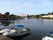
Harbor, where it empties into the Long Island Sound
Long Island Sound
Long Island Sound is an estuary of the Atlantic Ocean, located in the United States between Connecticut to the north and Long Island, New York to the south. The mouth of the Connecticut River at Old Saybrook, Connecticut, empties into the sound. On its western end the sound is bounded by the Bronx...
. The lower portion of the river is paralleled by the Merritt Parkway
Merritt Parkway
The Merritt Parkway is a historic limited-access parkway in Fairfield County, Connecticut. The parkway is known for its scenic layout, its uniquely styled signage, and the architecturally elaborate overpasses along the route. It is designated as a National Scenic Byway and is also listed in the...
in Connecticut and eventually forms the southernmost portion of the New York-Connecticut border.
The river has a 29 square miles (75.1 km²) drainage basin
Drainage basin
A drainage basin is an extent or an area of land where surface water from rain and melting snow or ice converges to a single point, usually the exit of the basin, where the waters join another waterbody, such as a river, lake, reservoir, estuary, wetland, sea, or ocean...
.
There are several dams on the river which are controlled by the Town of Greenwich.
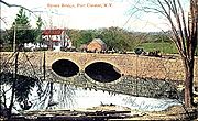
Several bridges cross the river. As of the summer of 2007, three of the bridges in northwest Greenwich had been identified by state inspectors as in critical need of repair, and all were scheduled for work:
- Bailiwick Road — already in poor shape, the bridge was further damaged by the nor'easter of April 15, 2007. In May emergency repairs were made. A redesign of the bridge may be needed to better protect against future flooding, town offiicals said.
- Riversville Road — Greenwich officials imposed weight restrictions on the bridge which were in effect in the summer of 2007. Dump trucks are prohibited from using it, but 10-ton box trucks and 15-ton semis are allowed.
- Sherwood Avenue — Greenwich officials imposed weight restrictions on the bridge which were in effect in the summer of 2007. Only 15-ton box trucks and 26-ton semis are allowed.
History
The Byram River was once a center of economic activity where shipbuilding and fishing were major industries. The Byram section of Greenwich is at the southern end of the river, on the Connecticut side.On April 15, 2007, a nor'easter
Nor'easter
A nor'easter is a type of macro-scale storm along the East Coast of the United States and Atlantic Canada, so named because the storm travels to the northeast from the south and the winds come from the northeast, especially in the coastal areas of the Northeastern United States and Atlantic Canada...
flooded areas near the river on both the Connecticut and New York sides. In July 2007, Greenwich town officials gave initial approval for spending $250,000 to study drainage improvement in flood-prone areas near the river, including the idea of dredging the river.