
Harlem River Drive
Encyclopedia
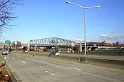
The Harlem River Drive is a north–south parkway
in the New York City
borough of Manhattan
. It runs along the west bank of the Harlem River
from the Triborough Bridge
in East Harlem to 10th Avenue in Inwood
, where the parkway continues north as Dyckman Street
. The portion of the Harlem River Drive from the Triborough Bridge to the Alexander Hamilton Bridge
is a limited-access highway. South of the Robert F. Kennedy Bridge, the parkway continues toward lower Manhattan as FDR Drive.
The parkway opened to traffic in 1964. In 2003, the New York State Department of Transportation
ceremoniously designated the parkway as the "369th Harlem Hellfighters
Drive" in honor of the all-black regiment that fought to defend France
during World War I
.
 The Drive originated as the Harlem River Speedway, which attracted horse owners. Genteel carriage
s were permitted, but not sulkies
and drays in the initial years. Later, car drivers could also race along the stretch of road. The dirt roadway stretched two and one-half miles from West 155th Street
to West 208th Street.
Robert Moses
envisioned the Harlem River Drive as a six-lane road linking the George Washington Bridge
and the East River Drive (now the FDR Drive) north of East 125th Street
. Traffic from the Triborough Bridge
and the several Harlem River bridges joining the Major Deegan Expressway
in the Bronx feed into the Drive. Sections of the old speedway in the path of the highway were incorporated into the new highway. Construction ended in 1964. The route as it stands today is designated as NY 907P, an unsigned reference route.
 A four-lane viaduct rises from the Harlem River Drive to connect to both decks of the George Washington Bridge (via the Trans-Manhattan Expressway
) and to Amsterdam Avenue
in the Washington Heights
section of Manhattan. The Harlem River Drive continues north to the Inwood
section of Manhattan, where it ends with connections to Tenth Avenue
and Dyckman Street.
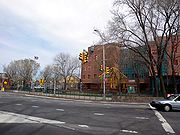
Starting at the beginning of the 21st century, the Manhattan Waterfront Greenway
runs between the river and the drive, from 155th to Dyckman, in a portion of Highbridge Park
which had been abandoned and fenced off approximately half a century.
(New York County).
{| class="wikitable"
!scope="col"|Mile
!scope="col"|Exit
!scope="col"|Destinations
!scope="col"|Notes
|-
|rowspan=2|0.00
|
|
|Continuation past the Triborough Bridge
|-
|17
| via RFK-Triborough Bridge
|
|-
|
|18
|Willis Avenue Bridge
– Mott Haven, The Bronx
|Northbound exit and southbound entrance
|-
|
|rowspan=2|19
|East 127th Street / 1st Avenue
|Northbound exit only
|-
|
|East 128th Street / 2nd Avenue
|Southbound exit and northbound entrance
|-
|0.68
|20
|Park Avenue
|Southbound exit and entrance
|-
|0.71
|21
|East 135th Street / Madison Avenue
|Northbound exit only
|-
|
|22
|West 142nd Street / 5th Avenue
|No northbound exit
|-
|
|23
|Frederick Douglass Boulevard / West 155th Street
|Southbound exit via Harlem River Drive service road
|-
|3.23
|24
|
|Northbound exit and southbound entrance
|-
|colspan=4 align="center"|North end of freeway section
|-
|rowspan=2|4.20
|
|10th Avenue
|
|-
|
|Dyckman Street
|Continuation past 10th Avenue
Parkway
The term parkway has several distinct principal meanings and numerous synonyms around the world, for either a type of landscaped area or a type of road.Type of landscaped area:...
in the New York City
New York City
New York is the most populous city in the United States and the center of the New York Metropolitan Area, one of the most populous metropolitan areas in the world. New York exerts a significant impact upon global commerce, finance, media, art, fashion, research, technology, education, and...
borough of Manhattan
Manhattan
Manhattan is the oldest and the most densely populated of the five boroughs of New York City. Located primarily on the island of Manhattan at the mouth of the Hudson River, the boundaries of the borough are identical to those of New York County, an original county of the state of New York...
. It runs along the west bank of the Harlem River
Harlem River
The Harlem River is a navigable tidal strait in New York City, USA that flows 8 miles between the Hudson River and the East River, separating the boroughs of Manhattan and the Bronx...
from the Triborough Bridge
Triborough Bridge
The Robert F. Kennedy ' Bridge, formerly known as the Triborough Bridge , is a complex of three separate bridges in New York City, United States...
in East Harlem to 10th Avenue in Inwood
Inwood, Manhattan
Inwood is the northernmost neighborhood on Manhattan Island in the New York City borough of Manhattan.-Geography:Inwood is physically bounded by the Harlem River to the north and east, and the Hudson River to the west. It extends southward to Fort Tryon Park and alternatively Dyckman Street or...
, where the parkway continues north as Dyckman Street
Dyckman Street
Dyckman Street is a street in the Inwood neighborhood of Manhattan, New York City. It is commonly considered to be a crosstown street because it runs from the Hudson River to the Harlem River and intersects Broadway...
. The portion of the Harlem River Drive from the Triborough Bridge to the Alexander Hamilton Bridge
Alexander Hamilton Bridge
The Alexander Hamilton Bridge carries eight lanes of traffic over the Harlem River in New York City between the boroughs of Manhattan and the Bronx, connecting the Trans-Manhattan Expressway in the Washington Heights section of Manhattan and the Cross-Bronx Expressway, as part of Interstate 95...
is a limited-access highway. South of the Robert F. Kennedy Bridge, the parkway continues toward lower Manhattan as FDR Drive.
The parkway opened to traffic in 1964. In 2003, the New York State Department of Transportation
New York State Department of Transportation
The New York State Department of Transportation is responsible for the development and operation of highways, railroads, mass transit systems, ports, waterways and aviation facilities in the U.S...
ceremoniously designated the parkway as the "369th Harlem Hellfighters
Harlem Hellfighters
The 369th Infantry Regiment, formerly the 15th New York National Guard Regiment, was an infantry regiment of the United States Army that saw action in World War I and World War II. The 369th Infantry is known for being the first African-American regiment to serve with the American Expeditionary...
Drive" in honor of the all-black regiment that fought to defend France
France
The French Republic , The French Republic , The French Republic , (commonly known as France , is a unitary semi-presidential republic in Western Europe with several overseas territories and islands located on other continents and in the Indian, Pacific, and Atlantic oceans. Metropolitan France...
during World War I
World War I
World War I , which was predominantly called the World War or the Great War from its occurrence until 1939, and the First World War or World War I thereafter, was a major war centred in Europe that began on 28 July 1914 and lasted until 11 November 1918...
.
History
Carriage
A carriage is a wheeled vehicle for people, usually horse-drawn; litters and sedan chairs are excluded, since they are wheelless vehicles. The carriage is especially designed for private passenger use and for comfort or elegance, though some are also used to transport goods. It may be light,...
s were permitted, but not sulkies
Sulky
A sulky is a lightweight cart having two wheels and a seat for the driver only but usually without a body, generally pulled by horses or dogs, and is used for harness races...
and drays in the initial years. Later, car drivers could also race along the stretch of road. The dirt roadway stretched two and one-half miles from West 155th Street
155th Street (Manhattan)
155th Street is a major crosstown street in the Harlem neighborhood, in the New York City borough of Manhattan. It is the northernmost of the 155 crosstown streets mapped out in the Commissioner's Plan of 1811 that established the numbered street grid in Manhattan.155th Street starts on the West...
to West 208th Street.
Robert Moses
Robert Moses
Robert Moses was the "master builder" of mid-20th century New York City, Long Island, Rockland County, and Westchester County, New York. As the shaper of a modern city, he is sometimes compared to Baron Haussmann of Second Empire Paris, and is one of the most polarizing figures in the history of...
envisioned the Harlem River Drive as a six-lane road linking the George Washington Bridge
George Washington Bridge
The George Washington Bridge is a suspension bridge spanning the Hudson River, connecting the Washington Heights neighborhood in the borough of Manhattan in New York City to Fort Lee, Bergen County, New Jersey. Interstate 95 and U.S. Route 1/9 cross the river via the bridge. U.S...
and the East River Drive (now the FDR Drive) north of East 125th Street
125th Street (Manhattan)
125th Street is a two-way street that runs east-west in the New York City borough of Manhattan, considered the "Main Street" of Harlem; It is also called Martin Luther King, Jr...
. Traffic from the Triborough Bridge
Triborough Bridge
The Robert F. Kennedy ' Bridge, formerly known as the Triborough Bridge , is a complex of three separate bridges in New York City, United States...
and the several Harlem River bridges joining the Major Deegan Expressway
Major Deegan Expressway
The Major Deegan Expressway is a north–south expressway in the New York City borough of the Bronx...
in the Bronx feed into the Drive. Sections of the old speedway in the path of the highway were incorporated into the new highway. Construction ended in 1964. The route as it stands today is designated as NY 907P, an unsigned reference route.
Trans-Manhattan Expressway
The Trans-Manhattan Expressway or George Washington Bridge Expressway is a highway in New York City that is part of the Interstate Highway System. Though few of the millions who use it or live near it have ever heard the name, it is probably one of the shortest, busiest, and most congested named...
) and to Amsterdam Avenue
Tenth Avenue (Manhattan)
Tenth Avenue, known as Amsterdam Avenue north of 59th Street, is a north-south thoroughfare on the West Side of Manhattan in New York City. It carries uptown traffic as far as West 110th Street, also known as Cathedral Parkway for the Cathedral Church of St. John the Divine...
in the Washington Heights
Washington Heights, Manhattan
Washington Heights is a New York City neighborhood in the northern reaches of the borough of Manhattan. It is named for Fort Washington, a fortification constructed at the highest point on Manhattan island by Continental Army troops during the American Revolutionary War, to defend the area from the...
section of Manhattan. The Harlem River Drive continues north to the Inwood
Inwood, Manhattan
Inwood is the northernmost neighborhood on Manhattan Island in the New York City borough of Manhattan.-Geography:Inwood is physically bounded by the Harlem River to the north and east, and the Hudson River to the west. It extends southward to Fort Tryon Park and alternatively Dyckman Street or...
section of Manhattan, where it ends with connections to Tenth Avenue
Tenth Avenue (Manhattan)
Tenth Avenue, known as Amsterdam Avenue north of 59th Street, is a north-south thoroughfare on the West Side of Manhattan in New York City. It carries uptown traffic as far as West 110th Street, also known as Cathedral Parkway for the Cathedral Church of St. John the Divine...
and Dyckman Street.
Starting at the beginning of the 21st century, the Manhattan Waterfront Greenway
Manhattan Waterfront Greenway
The Manhattan Waterfront Greenway is a foreshoreway for walking or cycling, long, around the island of Manhattan. The largest portions are operated by the New York City Department of Parks. It is separated from motor traffic, and many sections also separate pedestrians from cyclists...
runs between the river and the drive, from 155th to Dyckman, in a portion of Highbridge Park
Highbridge Park
Highbridge Park is located in Washington Heights on the banks of the Harlem River near the northernmost tip of the New York City borough of Manhattan, between 155th Street and Dyckman Street...
which had been abandoned and fenced off approximately half a century.
Exit list
The entire route is in ManhattanManhattan
Manhattan is the oldest and the most densely populated of the five boroughs of New York City. Located primarily on the island of Manhattan at the mouth of the Hudson River, the boundaries of the borough are identical to those of New York County, an original county of the state of New York...
(New York County).
{| class="wikitable"
!scope="col"|Mile
!scope="col"|Exit
!scope="col"|Destinations
!scope="col"|Notes
|-
|rowspan=2|0.00
|
|
|Continuation past the Triborough Bridge
|-
|17
| via RFK-Triborough Bridge
|
|-
|
|18
|Willis Avenue Bridge
Willis Avenue Bridge
The Willis Avenue Bridge is a swing bridge that carries road traffic northbound over the Harlem River between the New York City boroughs of Manhattan and the Bronx, United States. It connects First Avenue in Manhattan with Willis Avenue in the Bronx...
– Mott Haven, The Bronx
The Bronx
The Bronx is the northernmost of the five boroughs of New York City. It is also known as Bronx County, the last of the 62 counties of New York State to be incorporated...
|Northbound exit and southbound entrance
|-
|
|rowspan=2|19
|East 127th Street / 1st Avenue
|Northbound exit only
|-
|
|East 128th Street / 2nd Avenue
|Southbound exit and northbound entrance
|-
|0.68
|20
|Park Avenue
Park Avenue (Manhattan)
Park Avenue is a wide boulevard that carries north and southbound traffic in New York City borough of Manhattan. Through most of its length, it runs parallel to Madison Avenue to the west and Lexington Avenue to the east....
|Southbound exit and entrance
|-
|0.71
|21
|East 135th Street / Madison Avenue
|Northbound exit only
|-
|
|22
|West 142nd Street / 5th Avenue
|No northbound exit
|-
|
|23
|Frederick Douglass Boulevard / West 155th Street
|Southbound exit via Harlem River Drive service road
|-
|3.23
|24
|
|Northbound exit and southbound entrance
|-
|colspan=4 align="center"|North end of freeway section
|-
|rowspan=2|4.20
|
|10th Avenue
|
|-
|
|Dyckman Street
Dyckman Street
Dyckman Street is a street in the Inwood neighborhood of Manhattan, New York City. It is commonly considered to be a crosstown street because it runs from the Hudson River to the Harlem River and intersects Broadway...
|Continuation past 10th Avenue