

Montezuma Creek, Utah
Encyclopedia
Montezuma Creek is a census-designated place
(CDP) in San Juan County
, Utah
, United States
. The population was 507 at the 2000 census, a large increase over the 1990 figure of 345.
a public school for all ages, from pre-kindergarten to the sixth grade. The school's principal is Rebecca M. Benally.
Whitehorse Junior/Senior High School enrolls about 350 students from 7th to 12th grade. Many student activities is what makes
this school exciting and having students come back every year. The school's principal and vice-principal is veteran John M. Fahey and Kami Anderson.
The two together make an outstanding administration for the young Navajo students.
- A link to the Whitehorse High School, school page.
http://www.sanjuanschools.org/schools/whs/default.aspx
According to the United States Census Bureau
, the CDP has a total area of 12.5 square miles (32.4 km²), of which, 12.1 square miles (31.4 km²) of it is land and 0.4 square miles (1.1 km²) of it (3.27%) is water.
Montezuma Creek (San Juan River)
, named for a tributary of the San Juan River, is located within and partially outside the boundaries of the Navajo Nation
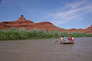
on the northwestern border of that vast Indian Reservation known locally as "The Rez." It is a center for oil and gas field work in the area, and a school as well as several churches.
of 2000, there were 507 people, 117 households, and 100 families residing in the CDP. The population density
was 41.8 people per square mile (16.2/km²). There were 170 housing units at an average density of 14.0/sq mi (5.4/km²). The racial makeup of the CDP was 96.06% Native American, 2.76% White, 0.39% from other races
, and 0.79% from two or more races. Hispanic or Latino of any race were 1.18% of the population.
There were 117 households out of which 61.5% had children under the age of 18 living with them, 66.7% were married couples
living together, 10.3% had a female householder with no husband present, and 13.7% were non-families. 12.0% of all households were made up of individuals and 2.6% had someone living alone who was 65 years of age or older. The average household size was 4.33 and the average family size was 4.75.
In the CDP the population was spread out with 44.6% under the age of 18, 9.5% from 18 to 24, 27.6% from 25 to 44, 16.2% from 45 to 64, and 2.2% who were 65 years of age or older. The median age was 21 years. For every 100 females there were 97.3 males. For every 100 females age 18 and over, there were 99.3 males.
The median income for a household in the CDP was $29,375, and the median income for a family was $30,208. Males had a median income of $27,292 versus $15,417 for females. The per capita income
for the CDP was $6,920. About 31.2% of families and 33.0% of the population were below the poverty line, including 23.1% of those under age 18 and 100.0% of those age 65 or over.
and Kenneth Maryboy
are the local delegates to the Navajo Nation Council.
 A large feature in Montezuma Creek is Top of the World, it is a prime gathering and social spot for locals. Its name is derived from it being the highest point in Montezuma Creek area. Benco gas station was destroyed by a fire in the year of 2009; Benco gas station was located in the heart of Montezuma Creek.
Census-designated place
A census-designated place is a concentration of population identified by the United States Census Bureau for statistical purposes. CDPs are delineated for each decennial census as the statistical counterparts of incorporated places such as cities, towns and villages...
(CDP) in San Juan County
San Juan County, Utah
As of the current census of 2010, there were 14,746 people and 4,505 households. The racial and ethnic composition of the population was 50.4% Native American, 45.8% white, 0.3% Asian, 0.2% African American and 2.3% reporting two or more races...
, Utah
Utah
Utah is a state in the Western United States. It was the 45th state to join the Union, on January 4, 1896. Approximately 80% of Utah's 2,763,885 people live along the Wasatch Front, centering on Salt Lake City. This leaves vast expanses of the state nearly uninhabited, making the population the...
, United States
United States
The United States of America is a federal constitutional republic comprising fifty states and a federal district...
. The population was 507 at the 2000 census, a large increase over the 1990 figure of 345.
Education
Montezuma Creek also is the center of education of about 500 Navajos in the area. Montezuma Creek Elementary School isa public school for all ages, from pre-kindergarten to the sixth grade. The school's principal is Rebecca M. Benally.
Whitehorse Junior/Senior High School enrolls about 350 students from 7th to 12th grade. Many student activities is what makes
this school exciting and having students come back every year. The school's principal and vice-principal is veteran John M. Fahey and Kami Anderson.
The two together make an outstanding administration for the young Navajo students.
- A link to the Whitehorse High School, school page.
http://www.sanjuanschools.org/schools/whs/default.aspx
Geography
Montezuma Creek is located at 37°15′37"N 109°18′6"W (37.260329, -109.301565).According to the United States Census Bureau
United States Census Bureau
The United States Census Bureau is the government agency that is responsible for the United States Census. It also gathers other national demographic and economic data...
, the CDP has a total area of 12.5 square miles (32.4 km²), of which, 12.1 square miles (31.4 km²) of it is land and 0.4 square miles (1.1 km²) of it (3.27%) is water.
Montezuma Creek (San Juan River)
Montezuma Creek (San Juan River)
Montezuma Creek is a tributary of the San Juan River. The river is approximately long and is a seasonal river, becoming dry for several months of the year.-Location:...
, named for a tributary of the San Juan River, is located within and partially outside the boundaries of the Navajo Nation
Navajo Nation
The Navajo Nation is a semi-autonomous Native American-governed territory covering , occupying all of northeastern Arizona, the southeastern portion of Utah, and northwestern New Mexico...
on the northwestern border of that vast Indian Reservation known locally as "The Rez." It is a center for oil and gas field work in the area, and a school as well as several churches.
Demographics
As of the censusCensus
A census is the procedure of systematically acquiring and recording information about the members of a given population. It is a regularly occurring and official count of a particular population. The term is used mostly in connection with national population and housing censuses; other common...
of 2000, there were 507 people, 117 households, and 100 families residing in the CDP. The population density
Population density
Population density is a measurement of population per unit area or unit volume. It is frequently applied to living organisms, and particularly to humans...
was 41.8 people per square mile (16.2/km²). There were 170 housing units at an average density of 14.0/sq mi (5.4/km²). The racial makeup of the CDP was 96.06% Native American, 2.76% White, 0.39% from other races
Race (United States Census)
Race and ethnicity in the United States Census, as defined by the Federal Office of Management and Budget and the United States Census Bureau, are self-identification data items in which residents choose the race or races with which they most closely identify, and indicate whether or not they are...
, and 0.79% from two or more races. Hispanic or Latino of any race were 1.18% of the population.
There were 117 households out of which 61.5% had children under the age of 18 living with them, 66.7% were married couples
Marriage
Marriage is a social union or legal contract between people that creates kinship. It is an institution in which interpersonal relationships, usually intimate and sexual, are acknowledged in a variety of ways, depending on the culture or subculture in which it is found...
living together, 10.3% had a female householder with no husband present, and 13.7% were non-families. 12.0% of all households were made up of individuals and 2.6% had someone living alone who was 65 years of age or older. The average household size was 4.33 and the average family size was 4.75.
In the CDP the population was spread out with 44.6% under the age of 18, 9.5% from 18 to 24, 27.6% from 25 to 44, 16.2% from 45 to 64, and 2.2% who were 65 years of age or older. The median age was 21 years. For every 100 females there were 97.3 males. For every 100 females age 18 and over, there were 99.3 males.
The median income for a household in the CDP was $29,375, and the median income for a family was $30,208. Males had a median income of $27,292 versus $15,417 for females. The per capita income
Per capita income
Per capita income or income per person is a measure of mean income within an economic aggregate, such as a country or city. It is calculated by taking a measure of all sources of income in the aggregate and dividing it by the total population...
for the CDP was $6,920. About 31.2% of families and 33.0% of the population were below the poverty line, including 23.1% of those under age 18 and 100.0% of those age 65 or over.
Government
Davis FilfredDavis Filfred
Davis Filfred is an American politician for the Navajo Nation Council Delegate in the Utah Navajo Section.Davis Filfred succeeded the position of retiring Navajo Councilman, Mark Maryboy in the Navajo Nation election process. Davis Filfred serves the same Navajo Nation districts along with Kenneth...
and Kenneth Maryboy
Kenneth Maryboy
Kenneth Maryboy is an American politician for San Juan County, Utah, and the current Navajo Nation Council Delegate for the Utah Navajo Section. Kenneth is also one of three San Juan County Commissioners who oversee the needs of the county's residents and the Utah Navajo Element...
are the local delegates to the Navajo Nation Council.
Places of interest