
Washington State Route 100
Encyclopedia
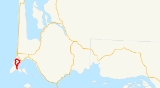
State Route 100 is a short state highway in Pacific County, in the U.S. state of Washington. It extends 4.38 miles (7.05 km) from U.S. Route 101
(US 101) in the city of Ilwaco
, counterclockwise to end at itself in the same city, about 0.06 mile (0.0965604 km) from its clockwise end with US 101. The route serves as a connector to SR 100 Spur, which goes south from SR 100 to Cape Disappointment State Park
at the southernmost point of the loop.
SR 100 was approved by the Washington State Legislature
in 1991 along its current route. Even though SR 100 was approved by the Washington State Legislature and WSDOT in 1991, no signs went up until the law that made SR 100 took effect on April 1, 1992. The spur route was also established in 1991.
(US 101) in the city of Ilwaco
, counterclockwise to end at itself in the same city, about 0.06 mile (0.0965604 km) from its counterclockwise end with US 101. The route serves as a connector to SR 100 Spur, which goes north from Cape Disappointment State Park
to SR 100 at the southernmost point of the loop. WSDOT has found that more than 2,200 motorists utilize the road daily after the intersection with US 101 based on average annual daily traffic (AADT) data.
SR 100 starts at an intersection with US 101 in Downtown Illwaco. It then becomes North Head Road and intersects 2nd Avenue SW, known as SR 100. After the intersection with 2nd Avenue SW, SR 100 goes west and becomes Robert Gray Drive. After turning south, SR 100 intersects SR 100 Spur, becomes Second Avenue SW and turns northeast towards Illwaco. Once in Illwaco, SR 100 turns north to intersect North Head Road, known as SR 100.
of SR 100 that runs south from SR 100 at the southernmost point of the loop to Cape Disappointment State Park
. The spur is signed north – south by WSDOT, unlike other highways in Washington, that are signed west – east or south – north. The highway is officially known as SR 100 Spur Canby, as it connects to Cape Disappointment State Park, formerly called Fort Canby State Park. More than 900 motorists use SR 100 daily based on AADT data.
U.S. Route 101 in Washington
In the U.S. state of Washington, U.S. Route 101 is the westernmost state highway, serving the Olympic Peninsula. It runs from the Astoria-Megler Bridge north to the cities of Raymond, Aberdeen, Hoquiam, and Forks before turning east at the small community of Beaver to the most northern point of the...
(US 101) in the city of Ilwaco
Ilwaco, Washington
Ilwaco is a city in Pacific County, Washington, United States. The population was 950 at the 2000 census and decreased to 936 at the 2010 census.-History:...
, counterclockwise to end at itself in the same city, about 0.06 mile (0.0965604 km) from its clockwise end with US 101. The route serves as a connector to SR 100 Spur, which goes south from SR 100 to Cape Disappointment State Park
Cape Disappointment State Park
Cape Disappointment State Park, formerly known as Fort Canby State Park, is a park located southwest of Ilwaco, Washington. The park is located on the southern part of Long Beach Peninsula, which is fronted by the Pacific Ocean. The park is one of several state parks and sites in Washington and...
at the southernmost point of the loop.
SR 100 was approved by the Washington State Legislature
Washington State Legislature
The Washington State Legislature is the state legislature of the U.S. state of Washington. It is a bipartisan, bicameral body, composed of the lower Washington House of Representatives, composed of 98 Representatives, and the upper Washington State Senate, with 49 Senators.The State Legislature...
in 1991 along its current route. Even though SR 100 was approved by the Washington State Legislature and WSDOT in 1991, no signs went up until the law that made SR 100 took effect on April 1, 1992. The spur route was also established in 1991.
Route description
SR 100 runs 4.38 miles (7.05 km) from U.S. Route 101U.S. Route 101 in Washington
In the U.S. state of Washington, U.S. Route 101 is the westernmost state highway, serving the Olympic Peninsula. It runs from the Astoria-Megler Bridge north to the cities of Raymond, Aberdeen, Hoquiam, and Forks before turning east at the small community of Beaver to the most northern point of the...
(US 101) in the city of Ilwaco
Ilwaco, Washington
Ilwaco is a city in Pacific County, Washington, United States. The population was 950 at the 2000 census and decreased to 936 at the 2010 census.-History:...
, counterclockwise to end at itself in the same city, about 0.06 mile (0.0965604 km) from its counterclockwise end with US 101. The route serves as a connector to SR 100 Spur, which goes north from Cape Disappointment State Park
Cape Disappointment State Park
Cape Disappointment State Park, formerly known as Fort Canby State Park, is a park located southwest of Ilwaco, Washington. The park is located on the southern part of Long Beach Peninsula, which is fronted by the Pacific Ocean. The park is one of several state parks and sites in Washington and...
to SR 100 at the southernmost point of the loop. WSDOT has found that more than 2,200 motorists utilize the road daily after the intersection with US 101 based on average annual daily traffic (AADT) data.
SR 100 starts at an intersection with US 101 in Downtown Illwaco. It then becomes North Head Road and intersects 2nd Avenue SW, known as SR 100. After the intersection with 2nd Avenue SW, SR 100 goes west and becomes Robert Gray Drive. After turning south, SR 100 intersects SR 100 Spur, becomes Second Avenue SW and turns northeast towards Illwaco. Once in Illwaco, SR 100 turns north to intersect North Head Road, known as SR 100.
History
SR 100 became a state highway in 1991, and the highway designation took effect on April 1, 1992.Major intersections
SR 100 Spur
State Route 100 Spur (SR 100 Spur) is a 0.09 mile (0.1448406 km) long spur routeSpur route
A spur route is a short road forming a branch from a longer, more important route . A bypass or beltway is never considered a true spur route as it typically reconnects with the major road...
of SR 100 that runs south from SR 100 at the southernmost point of the loop to Cape Disappointment State Park
Cape Disappointment State Park
Cape Disappointment State Park, formerly known as Fort Canby State Park, is a park located southwest of Ilwaco, Washington. The park is located on the southern part of Long Beach Peninsula, which is fronted by the Pacific Ocean. The park is one of several state parks and sites in Washington and...
. The spur is signed north – south by WSDOT, unlike other highways in Washington, that are signed west – east or south – north. The highway is officially known as SR 100 Spur Canby, as it connects to Cape Disappointment State Park, formerly called Fort Canby State Park. More than 900 motorists use SR 100 daily based on AADT data.