
Washington State Route 103
Encyclopedia
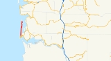
State Route 103 is a 19.97 miles (32.1 km) long state route located entirely in Pacific County, Washington, United States. The highway travels from U.S. Route 101
(US 101) in Seaview
to Leadbetter Point State Park
.
and intersects several minor roads in the towns before passing to the west of Briscoe Lake. The highway continues north along the peninsula, passing the Loomis Lake State Park on the west side of the highway, and Loomis Lake to the east of the highway. Entering Ocean Park
, the highway turns east onto Bay Avenue until intersecting and turning north onto Sandridge Road. The highway, parelling Willapa Bay
enters Oysterville
, turning west on Oysterville Road then north on Stackpole Road. The highway terminates at the entrance to Leadbetter Point State Park and I Street.
Every year the Washington State Department of Transportation
(WSDOT) conducts a series of surveys on its highways in the state to measure traffic volume. This is expressed in terms of average annual daily traffic (AADT), which is a measure of traffic volume for any average day of the year. In 2009, WSDOT calculated that as few as 280 cars traveled on the highway after the intersection at Oysterville Road, and as many as 8,200 cars used the highway between US 101 and 10th Street in Seaview.
U.S. Route 101 in Washington
In the U.S. state of Washington, U.S. Route 101 is the westernmost state highway, serving the Olympic Peninsula. It runs from the Astoria-Megler Bridge north to the cities of Raymond, Aberdeen, Hoquiam, and Forks before turning east at the small community of Beaver to the most northern point of the...
(US 101) in Seaview
Seaview, Washington
Seaview is an unincorporated area in Pacific County, Washington. It is part of the Long Beach, Washington urban cluster and had a population for its ZIP code at the 2000 census of 516 people.-Geography:...
to Leadbetter Point State Park
Leadbetter Point State Park
Leadbetter Point State Park is a Washington state park on the Long Beach Peninsula northwest of Oysterville, Washington. The park is bounded by Willapa Bay to the north and east and the Pacific Ocean to the west.-External links:*...
.
Route description
SR 103 begins at a t intersection between Pacific Way and 40th Street. US 101 is routed along Pacific way until this intersection, turning east onto 40th Street as SR 103 begins, traveling north on Pacific Way. The highway serves as the main street in Seaview and Long BeachLong Beach, Washington
Long Beach is a city in Pacific County, Washington, United States. The population was 1,283 at the 2000 census and grew to 1,392 at the 2010 census...
and intersects several minor roads in the towns before passing to the west of Briscoe Lake. The highway continues north along the peninsula, passing the Loomis Lake State Park on the west side of the highway, and Loomis Lake to the east of the highway. Entering Ocean Park
Ocean Park, Washington
Ocean Park is a census-designated place in Pacific County, Washington, United States. The population was 1,573 at the 2010 census.-Geography:Ocean Park is located at...
, the highway turns east onto Bay Avenue until intersecting and turning north onto Sandridge Road. The highway, parelling Willapa Bay
Willapa Bay
Willapa Bay is a bay located on the southwest Pacific coast of Washington state in the United States. The Long Beach Peninsula separates Willapa Bay from the greater expanse of the Pacific Ocean. With over of water surface Willapa Bay is the second largest estuary on the United States Pacific coast...
enters Oysterville
Oysterville, Washington
Oysterville is an unincorporated community in Pacific County, Washington, United States.-History:Oysterville was first settled in 1841 by John Douglas, who married a local Chinook woman. Oysterville was established and named in 1854 by J.A. Clark. It was a hub of oyster farming as the name suggests...
, turning west on Oysterville Road then north on Stackpole Road. The highway terminates at the entrance to Leadbetter Point State Park and I Street.
Every year the Washington State Department of Transportation
Washington State Department of Transportation
The Washington State Department of Transportation , was established in 1905. The agency, led by a Secretary and overseen by the Governor, is a Washington governmental agency that constructs, maintains, and regulates the use of the state's transportation infrastructure...
(WSDOT) conducts a series of surveys on its highways in the state to measure traffic volume. This is expressed in terms of average annual daily traffic (AADT), which is a measure of traffic volume for any average day of the year. In 2009, WSDOT calculated that as few as 280 cars traveled on the highway after the intersection at Oysterville Road, and as many as 8,200 cars used the highway between US 101 and 10th Street in Seaview.
Major intersections
The entire route is located in Pacific County.| Location | Mile | Destinations | Notes |
|---|---|---|---|
| Seaview Seaview, Washington Seaview is an unincorporated area in Pacific County, Washington. It is part of the Long Beach, Washington urban cluster and had a population for its ZIP code at the 2000 census of 516 people.-Geography:... |
0.00 | Southern terminus | |
| Leadbetter Point State Park Leadbetter Point State Park Leadbetter Point State Park is a Washington state park on the Long Beach Peninsula northwest of Oysterville, Washington. The park is bounded by Willapa Bay to the north and east and the Pacific Ocean to the west.-External links:*... |
19.97 |  |
Northern terminus |