
Evitts Mountain
Encyclopedia
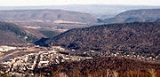
Evitts Mountain is a stratigraphic ridge
in the Ridge and Valley
region of the Appalachian Mountains
, located in Bedford County
, Pennsylvania
and Allegany County
, Maryland
in Maryland, across the Mason-Dixon Line
into Pennsylvania and then to the west Martin Hill
, passing very near Tussey Mountain
in Snake Spring Valley. The ridge then turns west, wrapping around north of Bedford, Pennsylvania
to its intersection with Dunning Mountain, dividing Dunning Cove from Morrison Cove
. The Raystown Branch Juniata River
passes through "The Narrows", a prominent water gap
along with the Pennsylvania Turnpike
and the now dismantled Bedford and Bridgeport Railroad near Bedford, Pennsylvania
. Evitts Creek runs through the base of the Mountain in Rocky Gap State Park.
and Bedford County, Pennsylvania
, thought by some to have gone by the last name of "Evart" (Evett, Evert, and Evit have also been proposed). In the 1780s, Mr. Evart decided to contemplate his bachelorhood from the isolated mountain top of what is today Evitts Mountain, at 39°43′13"N 78°39′35"W, now in Rocky Gap State Park, far from the comforts of society. At the top of the 2000 feet (609.6 m) mountain lies what its allegedly Mr. Evart's old homestead, from which he would return by the same route every day hiking a steep 3.5 miles (5.6 km) trail, now called Evitts Trail.
Ridge
A ridge is a geological feature consisting of a chain of mountains or hills that form a continuous elevated crest for some distance. Ridges are usually termed hills or mountains as well, depending on size. There are several main types of ridges:...
in the Ridge and Valley
Ridge-and-valley Appalachians
The Ridge-and-Valley Appalachians, also called the Ridge and Valley Province or the Valley and Ridge Appalachians, are a physiographic province of the larger Appalachian division and are also a belt within the Appalachian Mountains extending from southeastern New York through northwestern New...
region of the Appalachian Mountains
Appalachian Mountains
The Appalachian Mountains #Whether the stressed vowel is or ,#Whether the "ch" is pronounced as a fricative or an affricate , and#Whether the final vowel is the monophthong or the diphthong .), often called the Appalachians, are a system of mountains in eastern North America. The Appalachians...
, located in Bedford County
Bedford County, Pennsylvania
Bedford County is a county located in the U.S. state of Pennsylvania. As of the 2010 census, the population was 49,762. The county seat is Bedford. It is part of the Altoona, Pennsylvania, Metropolitan Statistical Area.- History :...
, Pennsylvania
Pennsylvania
The Commonwealth of Pennsylvania is a U.S. state that is located in the Northeastern and Mid-Atlantic regions of the United States. The state borders Delaware and Maryland to the south, West Virginia to the southwest, Ohio to the west, New York and Ontario, Canada, to the north, and New Jersey to...
and Allegany County
Allegany County, Maryland
Allegany County is a county located in the northwestern part of the US state of Maryland. It is part of the Cumberland, MD-WV Metropolitan Statistical Area. As of 2010, the population was 75,087. Its county seat is Cumberland...
, Maryland
Maryland
Maryland is a U.S. state located in the Mid Atlantic region of the United States, bordering Virginia, West Virginia, and the District of Columbia to its south and west; Pennsylvania to its north; and Delaware to its east...
Geography
The ridge line runs north from Rocky Gap State ParkRocky Gap State Park
Rocky Gap State Park is a 3,400 acre park in Allegany County, Maryland. It is seven miles east of Cumberland on Interstate 68 , and is about a two-hour drive from Washington, D.C., Baltimore and Pittsburgh, Pennsylvania...
in Maryland, across the Mason-Dixon Line
Mason-Dixon line
The Mason–Dixon Line was surveyed between 1763 and 1767 by Charles Mason and Jeremiah Dixon in the resolution of a border dispute between British colonies in Colonial America. It forms a demarcation line among four U.S. states, forming part of the borders of Pennsylvania, Maryland, Delaware, and...
into Pennsylvania and then to the west Martin Hill
Martin Hill
Martin Hill is a mountain ridge which connects Tussey Mountain to its east and Evitts Mountain to its west. Martin Hill is located in the Martin Hill Wild Area, which is a part of the Buchanan State Forest, in Bedford County, Pennsylvania...
, passing very near Tussey Mountain
Tussey Mountain
]Tussey Mountain is a stratigraphic ridge in central Pennsylvania, United States, trending east of the Bald Eagle, Brush, Dunning and Evitts Mountain ridges...
in Snake Spring Valley. The ridge then turns west, wrapping around north of Bedford, Pennsylvania
Bedford, Pennsylvania
Bedford is a borough in Bedford County, Pennsylvania, west of the State Capital, Harrisburg. It is the county seat of Bedford County. Bedford was established in the mid-18th century. Population counts follow: 1890, 2,242; 1900, 2,167; 1910, 2,385. The population was 3,141 at the 2000...
to its intersection with Dunning Mountain, dividing Dunning Cove from Morrison Cove
Morrison Cove
Morrisons Cove , is an eroded anticlinal valley in Blair and Bedford counties of central Pennsylvania, United States, extending from Evitts Mountain near New Enterprise, north to the Frankstown Branch Juniata River at Williamsburg...
. The Raystown Branch Juniata River
Raystown Branch Juniata River
The Raystown Branch Juniata River is the largest and longest tributary of the Juniata River in south-central Pennsylvania in the United States....
passes through "The Narrows", a prominent water gap
Water gap
A water gap is an opening or notch which flowing water has carved through a mountain range. Water gaps often offer a practical route for road and rail transport to cross mountain ridges.- Geology :...
along with the Pennsylvania Turnpike
Pennsylvania Turnpike
The Pennsylvania Turnpike is a toll highway system operated by the Pennsylvania Turnpike Commission in the Commonwealth of Pennsylvania, United States. The three sections of the turnpike system total . The main section extends from Ohio to New Jersey and is long...
and the now dismantled Bedford and Bridgeport Railroad near Bedford, Pennsylvania
Bedford, Pennsylvania
Bedford is a borough in Bedford County, Pennsylvania, west of the State Capital, Harrisburg. It is the county seat of Bedford County. Bedford was established in the mid-18th century. Population counts follow: 1890, 2,242; 1900, 2,167; 1910, 2,385. The population was 3,141 at the 2000...
. Evitts Creek runs through the base of the Mountain in Rocky Gap State Park.
Etymology
The mountain is named in honor of an early pioneer in Allegany County, MarylandAllegany County, Maryland
Allegany County is a county located in the northwestern part of the US state of Maryland. It is part of the Cumberland, MD-WV Metropolitan Statistical Area. As of 2010, the population was 75,087. Its county seat is Cumberland...
and Bedford County, Pennsylvania
Bedford County, Pennsylvania
Bedford County is a county located in the U.S. state of Pennsylvania. As of the 2010 census, the population was 49,762. The county seat is Bedford. It is part of the Altoona, Pennsylvania, Metropolitan Statistical Area.- History :...
, thought by some to have gone by the last name of "Evart" (Evett, Evert, and Evit have also been proposed). In the 1780s, Mr. Evart decided to contemplate his bachelorhood from the isolated mountain top of what is today Evitts Mountain, at 39°43′13"N 78°39′35"W, now in Rocky Gap State Park, far from the comforts of society. At the top of the 2000 feet (609.6 m) mountain lies what its allegedly Mr. Evart's old homestead, from which he would return by the same route every day hiking a steep 3.5 miles (5.6 km) trail, now called Evitts Trail.