
Tropicana - Las Vegas Boulevard intersection
Encyclopedia
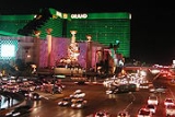
The Tropicana - Las Vegas Boulevard intersection on the Las Vegas Strip
(Tropicana Avenue and Las Vegas Boulevard
), is noteworthy for several reasons. It was the first intersection in Las Vegas completely closed to street level pedestrian traffic and its four corners are home to four major resort
s: Excalibur Hotel and Casino
, Tropicana Resort & Casino
, New York-New York Hotel & Casino
and MGM Grand Las Vegas
— the latter has 6,852 rooms and was once the largest hotel in the world. The resorts at the four corners have a total of 14,762 hotel rooms as of 2009.
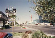
Tropicana Avenue is also the main local street into McCarran International Airport
and the first major exit from I-15 to the Strip for traffic heading north from the Los Angeles
and San Diego
areas. The heavy local traffic on Las Vegas Boulevard, which is listed as a National Scenic Byway
All-American Road, further adds to the number of vehicles in this area, making the intersection one of the busiest in the nation.
 After much study, Clark County
officials decided that the only solution to reducing accidents at this intersection that would improve pedestrian and vehicular traffic flow would be to separate the vehicles and pedestrians.
Tunnels were considered, but being enclosed and underground posed extra security risks, so a solution of uncovered walkways over the streets, using escalators and elevator
s for access, was selected as the best solution.
An elevated
pedestrian
open air walkway
was constructed across each of the streets instead of the normal crosswalks. Platforms at the ends of the walkways provide elevator and escalator access between the street and walkway level. The final step was to barricade the sidewalks from the roads in the vicinity of the intersection.
Las Vegas Strip
The Las Vegas Strip is an approximately stretch of Las Vegas Boulevard in Clark County, Nevada; adjacent to, but outside the city limits of Las Vegas proper. The Strip lies within the unincorporated townships of Paradise and Winchester...
(Tropicana Avenue and Las Vegas Boulevard
Las Vegas Boulevard
State Route 604 is the route number designation for parts of Las Vegas Boulevard, a major north–south road in the Las Vegas metropolitan area of Nevada in the United States best known for the Las Vegas Strip and its casinos. Formerly carrying U.S...
), is noteworthy for several reasons. It was the first intersection in Las Vegas completely closed to street level pedestrian traffic and its four corners are home to four major resort
Resort
A resort is a place used for relaxation or recreation, attracting visitors for holidays or vacations. Resorts are places, towns or sometimes commercial establishment operated by a single company....
s: Excalibur Hotel and Casino
Excalibur Hotel and Casino
The Excalibur Hotel and Casino is a hotel and casino located on the Las Vegas Strip in Paradise, Nevada, in the United States. It is owned and operated by MGM Resorts International....
, Tropicana Resort & Casino
Tropicana Resort & Casino
Tropicana Las Vegas is located on the Las Vegas Strip, in the township of Paradise, Nevada. It is owned by Tropicana Las Vegas Hotel and Resort Inc. and operated by Alex Yemenidjian's Armenco Holdings. It offers 1,658 rooms and is attached to a casino...
, New York-New York Hotel & Casino
New York-New York Hotel & Casino
New York-New York Hotel & Casino is a hotel and casino located on the Las Vegas Strip at 3790 Las Vegas Boulevard South, in Paradise, Nevada. It is owned and operated by MGM Resorts International.-Description:...
and MGM Grand Las Vegas
MGM Grand Las Vegas
The MGM Grand Las Vegas is a hotel casino located on the Las Vegas Strip in Paradise, Nevada. The MGM Grand is the third largest hotel in the world and largest hotel resort complex in the United States in front of The Venetian. The MGM Grand was the largest hotel in the world when it opened in...
— the latter has 6,852 rooms and was once the largest hotel in the world. The resorts at the four corners have a total of 14,762 hotel rooms as of 2009.
Tropicana Avenue is also the main local street into McCarran International Airport
McCarran International Airport
McCarran International Airport is the principal commercial airport serving Las Vegas and Clark County, Nevada, United States. The airport is located five miles south of the central business district of Las Vegas, in the unincorporated area of Paradise in Clark County. It covers an area of and...
and the first major exit from I-15 to the Strip for traffic heading north from the Los Angeles
Los Angeles, California
Los Angeles , with a population at the 2010 United States Census of 3,792,621, is the most populous city in California, USA and the second most populous in the United States, after New York City. It has an area of , and is located in Southern California...
and San Diego
San Diego, California
San Diego is the eighth-largest city in the United States and second-largest city in California. The city is located on the coast of the Pacific Ocean in Southern California, immediately adjacent to the Mexican border. The birthplace of California, San Diego is known for its mild year-round...
areas. The heavy local traffic on Las Vegas Boulevard, which is listed as a National Scenic Byway
National Scenic Byway
A National Scenic Byway is a road recognized by the United States Department of Transportation for its archeological, cultural, historic, natural, recreational, and/or scenic qualities. The program was established by Congress in 1991 to preserve and protect the nation's scenic but often...
All-American Road, further adds to the number of vehicles in this area, making the intersection one of the busiest in the nation.
History
Clark County, Nevada
-Demographics:As of the census of 2000, there were 1,375,765 people, 512,253 households, and 339,693 families residing within the MSA. The racial makeup of the MSA was 71.6% White , 9.1% Black, 5.7% Asian, 0.8% American Indian and 12.8% of other or mixed race. 22.0% were Hispanic of any race...
officials decided that the only solution to reducing accidents at this intersection that would improve pedestrian and vehicular traffic flow would be to separate the vehicles and pedestrians.
Tunnels were considered, but being enclosed and underground posed extra security risks, so a solution of uncovered walkways over the streets, using escalators and elevator
Elevator
An elevator is a type of vertical transport equipment that efficiently moves people or goods between floors of a building, vessel or other structures...
s for access, was selected as the best solution.
An elevated
Elevation
The elevation of a geographic location is its height above a fixed reference point, most commonly a reference geoid, a mathematical model of the Earth's sea level as an equipotential gravitational surface ....
pedestrian
Pedestrian
A pedestrian is a person traveling on foot, whether walking or running. In some communities, those traveling using roller skates or skateboards are also considered to be pedestrians. In modern times, the term mostly refers to someone walking on a road or footpath, but this was not the case...
open air walkway
Walkway
In US English, a walkway is a composite or umbrella term for all engineered surfaces or structures which support the use of trails. These include sidewalks, footbridges, stiles, stairs, ramps, paseos or tunnels...
was constructed across each of the streets instead of the normal crosswalks. Platforms at the ends of the walkways provide elevator and escalator access between the street and walkway level. The final step was to barricade the sidewalks from the roads in the vicinity of the intersection.