
Tropical cyclone forecasting
Encyclopedia
Tropical cyclone forecasting is the science and art of forecasting where a tropical cyclone
's center, and its effects, are expected to be at some point in the future. There are several elements to tropical cyclone forecasting: track forecasting, intensity forecasting, rainfall forecasting, storm surge, and tornado forecasting. While skill is increasing in regards to track forecasting, intensity forecasting skill remains nearly unchanged over the past several years.
during the 1870s. Before the early 1900s, though, most forecasts were done by direct observations at weather stations, which were then relayed to forecast centers via telegraph. It wasn’t until the advent of radio
in the early twentieth century that observations from ships at sea were available to forecasters. The 1930s saw the usage of radiosonde
s in tropical cyclone forecasting. The next decade saw the advent of aircraft-based reconnaissance by the military, starting with the first dedicated flight into a hurricane in 1943, and the establishment of the Hurricane Hunters
in 1944. In the 1950s, coastal weather radar
s began to be used in the United States, and research reconnaissance flights by the precursor of the Hurricane Research Division
began in 1954.
The launch of the first weather satellite, TIROS-I, in 1960, introduced new forecasting techniques that remain important to tropical cyclone forecasting to the present. In the 1970s, buoys were introduced to improve the resolution of surface measurements, which until that point, were not available at all over sea surfaces.
 The large-scale synoptic flow
determines 70 to 90 percent of a tropical cyclone's motion. The deep-layer mean flow is considered to be the best tool in determining track direction and speed. If storms are significantly sheared, use of a lower-level wind is a better predictor. Knowledge of the beta effect can be used to steer a tropical cyclone, since it leads to a more northwest heading for tropical cyclones in the Northern Hemisphere. It is also best to smooth out short term wobbles of the storm center in order to determine a more accurate trajectory.
Because of the forces that affect tropical cyclone tracks, accurate track predictions depend on determining the position and strength of high- and low-pressure areas, and predicting how those areas will change during the life of a tropical system. Combining forecast models with increased understanding of the forces that act on tropical cyclones, and a wealth of data from Earth-orbiting satellites and other sensors, scientists have increased the accuracy of track forecasts over recent decades. An accurate track forecast is important, because if the track forecast is incorrect, forecasts for intensity, rainfall, storm surge, and tornado threat will also be incorrect.
 The 1-2-3 rule (mariners' 1-2-3 rule or danger area) is a guideline commonly taught to mariners
for severe storm
(specifically hurricane and tropical storm) tracking and prediction. It refers to the rounded long-term NHC/TPC
forecast errors of 100-200-300 nautical mile
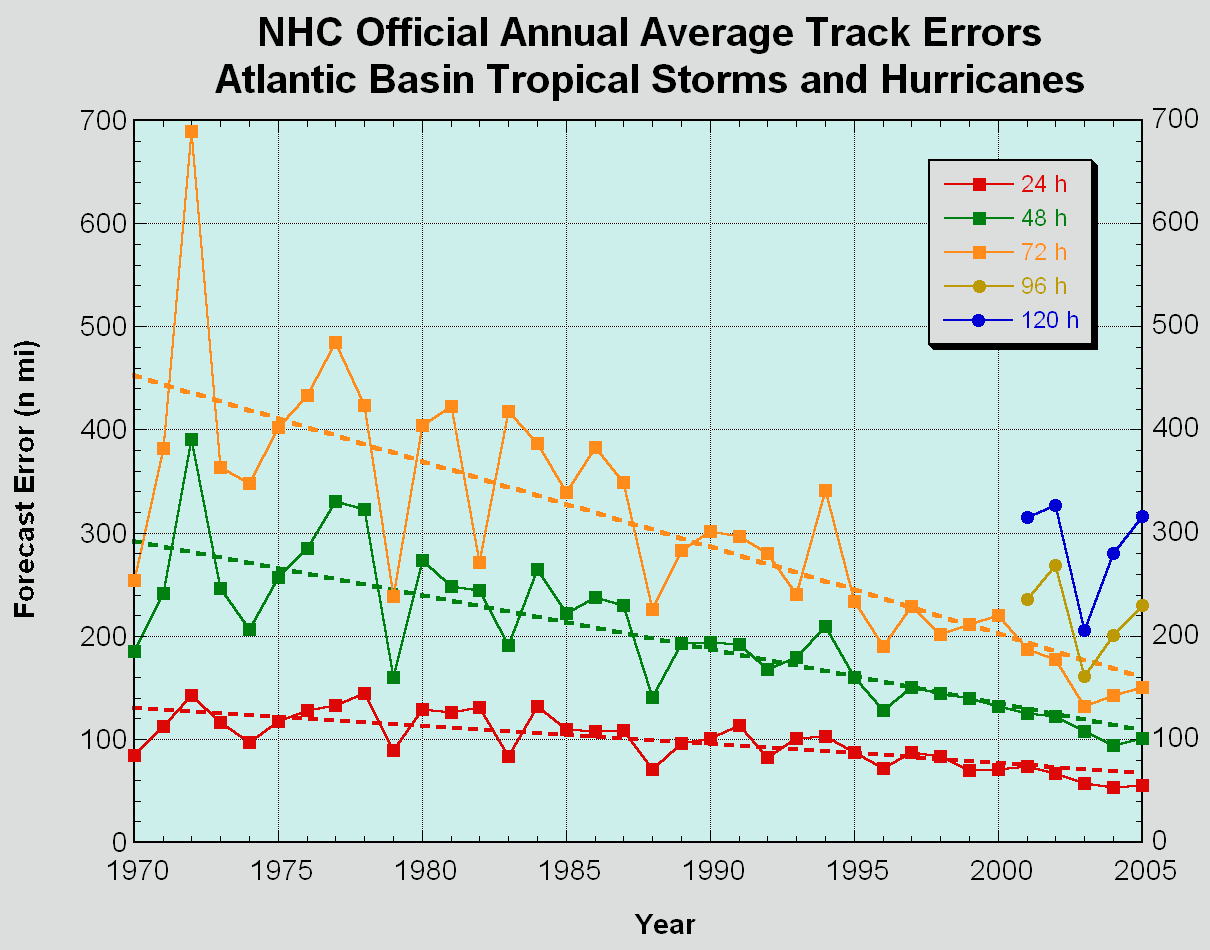
s at 24-48-72 hours, respectively. However, these errors have decreased to near 50-100-150 as NHC forecasters become more accurate. The "danger area" to be avoided is constructed by expanding the forecast path by a radius equal to the respective hundreds of miles plus the forecast wind radii (size of the storm at those hours).
An accurate track forecast is essential to creating accurate intensity forecasts, particularly in an area with large islands such as the western north Pacific and the Caribbean Sea, as proximity to land is an inhibiting factor to developing tropical cyclones. A strong hurricane/typhoon/cyclone can weaken if an outer eye wall forms (typically around 80-160 kilometers (50–100 miles) from the center of the storm), choking off the convection within the inner eye wall. Such weakening is called an eyewall replacement cycle
, and is usually temporary.
Dr. Kerry Emanuel created a mathematical model
around 1988, called the maximum potential intensity or MPI, to compute the upper limit of tropical cyclone intensity based on sea surface temperature and atmospheric profiles from the latest global model runs. Maps created from this equation show values of the maximum achievable intensity due to the thermodynamics
of the atmosphere at the time of the last model run (either 0000 or 1200 UTC). It does not take vertical wind shear
into account.
Tropical cyclone rainfall forecasting is important, since between 1970–2004, inland flooding from tropical cyclones caused a majority of the fatalities from tropical cyclones in the United States
. While flood
ing is common to tropical cyclones near a landmass, there are a few factors which lead to excessive rainfall from tropical cyclones. Slow motion, as was seen during Hurricane Danny
and Hurricane Wilma
, can lead to high amounts. The presence of topography near the coast, as is the case across much of Mexico
, Haiti
, the Dominican Republic
, much of Central America
, Madagascar
, Réunion
, China
, and Japan
acts to magnify amounts due to upslope flow into the mountains. Strong upper level forcing from a trough moving through the Westerlies, as was the case during Hurricane Floyd
, can lead to high amounts even from systems moving at an average forward motion. A combination of two of these factors could be especially crippling, as was seen during Hurricane Mitch
in Central America
. Therefore, an accurate track forecast is essential in order to produce an accurate tropical cyclone rainfall forecast.
. An accurate forecast track is required in order to produce accurate storm surge forecasts. However, if the landfall point is uncertain, a maximum envelope of water (MEOW) map can be generated based on the direction of approach. If the forecast track itself is also uncertain, a maximum of maximums (MoM) map can be generated which will show the worst possible scenario for a hurricane of a specific strength.
in the United States considers the effects of the El Niño-Southern Oscillation
, 25-40 year tropical cycle, wind shear
over the oceans, and ocean surface temperature.
Tropical cyclone
A tropical cyclone is a storm system characterized by a large low-pressure center and numerous thunderstorms that produce strong winds and heavy rain. Tropical cyclones strengthen when water evaporated from the ocean is released as the saturated air rises, resulting in condensation of water vapor...
's center, and its effects, are expected to be at some point in the future. There are several elements to tropical cyclone forecasting: track forecasting, intensity forecasting, rainfall forecasting, storm surge, and tornado forecasting. While skill is increasing in regards to track forecasting, intensity forecasting skill remains nearly unchanged over the past several years.
History
The methods through which tropical cyclones are forecast have changed with the passage of time. The first known forecasts in the Western Hemisphere were made by Lt. Col. William Reed of the Corps of Royal Engineers at Barbados in 1847. Reed mostly utilized barometric pressure measurements as the basis of his forecasts. Benito Vines introduced a forecast and warning system based on cloud cover changes in HavanaHavana
Havana is the capital city, province, major port, and leading commercial centre of Cuba. The city proper has a population of 2.1 million inhabitants, and it spans a total of — making it the largest city in the Caribbean region, and the most populous...
during the 1870s. Before the early 1900s, though, most forecasts were done by direct observations at weather stations, which were then relayed to forecast centers via telegraph. It wasn’t until the advent of radio
Radio
Radio is the transmission of signals through free space by modulation of electromagnetic waves with frequencies below those of visible light. Electromagnetic radiation travels by means of oscillating electromagnetic fields that pass through the air and the vacuum of space...
in the early twentieth century that observations from ships at sea were available to forecasters. The 1930s saw the usage of radiosonde
Radiosonde
A radiosonde is a unit for use in weather balloons that measures various atmospheric parameters and transmits them to a fixed receiver. Radiosondes may operate at a radio frequency of 403 MHz or 1680 MHz and both types may be adjusted slightly higher or lower as required...
s in tropical cyclone forecasting. The next decade saw the advent of aircraft-based reconnaissance by the military, starting with the first dedicated flight into a hurricane in 1943, and the establishment of the Hurricane Hunters
Hurricane Hunters
The Hurricane Hunters are aircraft that fly into tropical cyclones in the North Atlantic Ocean and Northeastern Pacific Ocean for the specific purpose of directly measuring weather data in and around those storms. In the United States, the Air Force, Navy, and NOAA units have all participated in...
in 1944. In the 1950s, coastal weather radar
Weather radar
Weather radar, also called weather surveillance radar and Doppler weather radar, is a type of radar used to locate precipitation, calculate its motion, estimate its type . Modern weather radars are mostly pulse-Doppler radars, capable of detecting the motion of rain droplets in addition to the...
s began to be used in the United States, and research reconnaissance flights by the precursor of the Hurricane Research Division
Atlantic Oceanographic and Meteorological Laboratory
The Atlantic Oceanographic and Meteorological Laboratory , a federal research laboratory, is part of National Oceanic and Atmospheric Administration's Office of Oceanic and Atmospheric Research , located in Miami, Florida...
began in 1954.
The launch of the first weather satellite, TIROS-I, in 1960, introduced new forecasting techniques that remain important to tropical cyclone forecasting to the present. In the 1970s, buoys were introduced to improve the resolution of surface measurements, which until that point, were not available at all over sea surfaces.
Track
Synoptic scale meteorology
The synoptic scale in meteorology is a horizontal length scale of the order of 1000 kilometres or more. This corresponds to a horizontal scale typical of mid-latitude depressions...
determines 70 to 90 percent of a tropical cyclone's motion. The deep-layer mean flow is considered to be the best tool in determining track direction and speed. If storms are significantly sheared, use of a lower-level wind is a better predictor. Knowledge of the beta effect can be used to steer a tropical cyclone, since it leads to a more northwest heading for tropical cyclones in the Northern Hemisphere. It is also best to smooth out short term wobbles of the storm center in order to determine a more accurate trajectory.
Because of the forces that affect tropical cyclone tracks, accurate track predictions depend on determining the position and strength of high- and low-pressure areas, and predicting how those areas will change during the life of a tropical system. Combining forecast models with increased understanding of the forces that act on tropical cyclones, and a wealth of data from Earth-orbiting satellites and other sensors, scientists have increased the accuracy of track forecasts over recent decades. An accurate track forecast is important, because if the track forecast is incorrect, forecasts for intensity, rainfall, storm surge, and tornado threat will also be incorrect.
1-2-3 rule
Sailor
A sailor, mariner, or seaman is a person who navigates water-borne vessels or assists in their operation, maintenance, or service. The term can apply to professional mariners, military personnel, and recreational sailors as well as a plethora of other uses...
for severe storm
Storm
A storm is any disturbed state of an astronomical body's atmosphere, especially affecting its surface, and strongly implying severe weather...
(specifically hurricane and tropical storm) tracking and prediction. It refers to the rounded long-term NHC/TPC
National Hurricane Center
The National Hurricane Center , located at Florida International University in Miami, Florida, is the division of the National Weather Service responsible for tracking and predicting weather systems within the tropics between the Prime Meridian and the 140th meridian west poleward to the 30th...
forecast errors of 100-200-300 nautical mile
Nautical mile
The nautical mile is a unit of length that is about one minute of arc of latitude along any meridian, but is approximately one minute of arc of longitude only at the equator...
s at 24-48-72 hours, respectively. However, these errors have decreased to near 50-100-150 as NHC forecasters become more accurate. The "danger area" to be avoided is constructed by expanding the forecast path by a radius equal to the respective hundreds of miles plus the forecast wind radii (size of the storm at those hours).
Intensity
Forecasters say they are less skillful at predicting the intensity of tropical cyclones than cyclone track. They attribute the lack of improvement in intensity forecasting to the complexity of tropical systems and an incomplete understanding of factors that affect their development.An accurate track forecast is essential to creating accurate intensity forecasts, particularly in an area with large islands such as the western north Pacific and the Caribbean Sea, as proximity to land is an inhibiting factor to developing tropical cyclones. A strong hurricane/typhoon/cyclone can weaken if an outer eye wall forms (typically around 80-160 kilometers (50–100 miles) from the center of the storm), choking off the convection within the inner eye wall. Such weakening is called an eyewall replacement cycle
Eyewall replacement cycle
Eyewall replacement cycles, also called concentric eyewall cycles, naturally occur in intense tropical cyclones, generally with winds greater than 185 km/h , or major hurricanes...
, and is usually temporary.
Dr. Kerry Emanuel created a mathematical model
Mathematical model
A mathematical model is a description of a system using mathematical concepts and language. The process of developing a mathematical model is termed mathematical modeling. Mathematical models are used not only in the natural sciences and engineering disciplines A mathematical model is a...
around 1988, called the maximum potential intensity or MPI, to compute the upper limit of tropical cyclone intensity based on sea surface temperature and atmospheric profiles from the latest global model runs. Maps created from this equation show values of the maximum achievable intensity due to the thermodynamics
Thermodynamics
Thermodynamics is a physical science that studies the effects on material bodies, and on radiation in regions of space, of transfer of heat and of work done on or by the bodies or radiation...
of the atmosphere at the time of the last model run (either 0000 or 1200 UTC). It does not take vertical wind shear
Wind shear
Wind shear, sometimes referred to as windshear or wind gradient, is a difference in wind speed and direction over a relatively short distance in the atmosphere...
into account.
Rainfall
Tropical cyclone rainfall forecasting is important, since between 1970–2004, inland flooding from tropical cyclones caused a majority of the fatalities from tropical cyclones in the United States
United States
The United States of America is a federal constitutional republic comprising fifty states and a federal district...
. While flood
Flood
A flood is an overflow of an expanse of water that submerges land. The EU Floods directive defines a flood as a temporary covering by water of land not normally covered by water...
ing is common to tropical cyclones near a landmass, there are a few factors which lead to excessive rainfall from tropical cyclones. Slow motion, as was seen during Hurricane Danny
Hurricane Danny (1997)
Hurricane Danny was the only hurricane to make landfall in the United States during the 1997 Atlantic hurricane season, and the second hurricane and fourth tropical storm of the season...
and Hurricane Wilma
Hurricane Wilma
Hurricane Wilma was the most intense tropical cyclone ever recorded in the Atlantic basin. Wilma was the twenty-second storm , thirteenth hurricane, sixth major hurricane, and fourth Category 5 hurricane of the record-breaking 2005 season...
, can lead to high amounts. The presence of topography near the coast, as is the case across much of Mexico
Mexico
The United Mexican States , commonly known as Mexico , is a federal constitutional republic in North America. It is bordered on the north by the United States; on the south and west by the Pacific Ocean; on the southeast by Guatemala, Belize, and the Caribbean Sea; and on the east by the Gulf of...
, Haiti
Haiti
Haiti , officially the Republic of Haiti , is a Caribbean country. It occupies the western, smaller portion of the island of Hispaniola, in the Greater Antillean archipelago, which it shares with the Dominican Republic. Ayiti was the indigenous Taíno or Amerindian name for the island...
, the Dominican Republic
Dominican Republic
The Dominican Republic is a nation on the island of La Hispaniola, part of the Greater Antilles archipelago in the Caribbean region. The western third of the island is occupied by the nation of Haiti, making Hispaniola one of two Caribbean islands that are shared by two countries...
, much of Central America
Central America
Central America is the central geographic region of the Americas. It is the southernmost, isthmian portion of the North American continent, which connects with South America on the southeast. When considered part of the unified continental model, it is considered a subcontinent...
, Madagascar
Madagascar
The Republic of Madagascar is an island country located in the Indian Ocean off the southeastern coast of Africa...
, Réunion
Réunion
Réunion is a French island with a population of about 800,000 located in the Indian Ocean, east of Madagascar, about south west of Mauritius, the nearest island.Administratively, Réunion is one of the overseas departments of France...
, China
China
Chinese civilization may refer to:* China for more general discussion of the country.* Chinese culture* Greater China, the transnational community of ethnic Chinese.* History of China* Sinosphere, the area historically affected by Chinese culture...
, and Japan
Japan
Japan is an island nation in East Asia. Located in the Pacific Ocean, it lies to the east of the Sea of Japan, China, North Korea, South Korea and Russia, stretching from the Sea of Okhotsk in the north to the East China Sea and Taiwan in the south...
acts to magnify amounts due to upslope flow into the mountains. Strong upper level forcing from a trough moving through the Westerlies, as was the case during Hurricane Floyd
Hurricane Floyd
Hurricane Floyd was the sixth named storm, fourth hurricane, and third major hurricane in the 1999 Atlantic hurricane season. Floyd triggered the third largest evacuation in US history when 2.6 million coastal residents of five states were ordered from their homes as it approached...
, can lead to high amounts even from systems moving at an average forward motion. A combination of two of these factors could be especially crippling, as was seen during Hurricane Mitch
Hurricane Mitch
Hurricane Mitch was the most powerful hurricane and the most destructive of the 1998 Atlantic hurricane season, with maximum sustained winds of 180 mph . The storm was the thirteenth tropical storm, ninth hurricane, and third major hurricane of the season. Along with Hurricane Georges, Mitch...
in Central America
Central America
Central America is the central geographic region of the Americas. It is the southernmost, isthmian portion of the North American continent, which connects with South America on the southeast. When considered part of the unified continental model, it is considered a subcontinent...
. Therefore, an accurate track forecast is essential in order to produce an accurate tropical cyclone rainfall forecast.
Storm surge
The main storm surge forecast model in the Atlantic basin is SLOSH, which stands for Sea, Lake, Overland, Surge from Hurricanes. It uses the size of a storm, its intensity, its forward motion, and the topography of the coastal plain to estimate the depth of a storm surge at any individual grid point across the United StatesUnited States
The United States of America is a federal constitutional republic comprising fifty states and a federal district...
. An accurate forecast track is required in order to produce accurate storm surge forecasts. However, if the landfall point is uncertain, a maximum envelope of water (MEOW) map can be generated based on the direction of approach. If the forecast track itself is also uncertain, a maximum of maximums (MoM) map can be generated which will show the worst possible scenario for a hurricane of a specific strength.
Tornado
The location of most tropical cyclone-related tornadoes is their northeast quadrant in the Northern Hemisphere and southeast quadrant in the Southern Hemisphere. Like most of the other forecasts for tropical cyclone effects, an accurate track forecast is required in order to produce an accurate tornado threat forecast.Seasonal forecast
By looking at annual variations in various climate parameters, forecasters can make predictions about the overall number and intensity of tropical cyclones that will occur in a given season. For example, when constructing its seasonal outlooks, the Climate Prediction CenterClimate Prediction Center
The Climate Prediction Center is one of the National Centers for Environmental Prediction, which are a part of NOAA's National Weather Service. It is located in Camp Springs, Maryland.-Products:...
in the United States considers the effects of the El Niño-Southern Oscillation
El Niño-Southern Oscillation
El Niño/La Niña-Southern Oscillation, or ENSO, is a quasiperiodic climate pattern that occurs across the tropical Pacific Ocean roughly every five years...
, 25-40 year tropical cycle, wind shear
Wind shear
Wind shear, sometimes referred to as windshear or wind gradient, is a difference in wind speed and direction over a relatively short distance in the atmosphere...
over the oceans, and ocean surface temperature.
See also
- List of tropical cyclones
- Hebert BoxHebert boxAn Hebert Box is one of two regions of the tropical Atlantic Ocean that are useful as predictors of hurricanes that will strike South Florida, USA...
- William M. GrayWilliam M. GrayWilliam M. "Bill" Gray is Emeritus Professor of Atmospheric Science at Colorado State University , and head of the Tropical Meteorology Project at CSU's Department of Atmospheric Sciences. He is a pioneer in the science of forecasting hurricanes and one of the world's leading experts on tropical...