
.gif)
Tropical Storm Nicholas (2003)
Encyclopedia
Tropical Storm Nicholas was a long-lived tropical storm
in October and November of the 2003 Atlantic hurricane season
. Forming from a tropical wave
on October 13 in the central tropical Atlantic Ocean
, Nicholas slowly developed due to moderate levels of wind shear throughout its lifetime. Deep convection slowly organized, and Nicholas attained a peak intensity of 70 mph (110 km/h) on October 17. After moving west-northwestward for much of its lifetime, it turned northward and weakened due to increasing shear. The storm again turned to the west and briefly restrengthened, but after turning again to the north Nicholas transitioned to an extratropical cyclone on October 24. As an extratropical storm, Nicholas executed a large loop to the west, and after moving erratically for a week and organizing into a tropical low, it was absorbed by a non-tropical low. The low continued westward, crossed Florida
, and ultimately dissipated over the Gulf Coast of the United States
on November 5.
Nicholas had no impact as a tropical cyclone, and impact from the low that absorbed the storm was limited to rainfall, gusty winds, and rough surf. Nicholas extended the above average levels of tropical cyclone activity throughout the 2003 season, and was one of fourteen seasons to reach fourteen storms. The low that absorbed the storm nearly developed into a tropical cyclone, which would have been called Odette. However, moderate wind shear
prevented further development.
that moved off the coast of Africa
on October 9. It moved westward, and developed a broad area of low pressure
along the wave on October 10. Convection organized around the low early on October 12 while located 800 miles (1300 km) southwest of the Cape Verde
islands. As upper level winds became more favorable, the system became better organized, though the circulation center initially remained located to the west of the area of heavy showers. The surface circulation of the large circulation envelope moved towards a position near the western edge of the deepest convection, and it is estimated the system developed into Tropical Depression Nineteen late on October 13 while located 1,030 miles (1,660 km) west-southwest of the Cape Verde islands.
Located within an area of moderate southwesterly wind shear
, the depression was slow to organize; early on October 14, a clear center was not depicted on Infrared
satellite imagery. The depression moved to the west-northwest and gradually strengthened into Tropical Storm Nicholas late on October 14 while located 1,200 miles (1,930 km) east of the Windward Islands
. On October 15, deep convection became much better organized, though the center of Nicholas remained displaced from the deepest of the shower activity. Despite the shear, the storm continued to strengthen as it moved to the west-northwest, a motion caused by a mid-level ridge
to its north. On October 16, Nicholas transitioned from a sheared, unorganized system to a more organized system, as a result of banding features and improvement in its convective pattern due to lesser amounts of vertical shear and a healthier anticyclone
over the storm. Nicholas continued to strengthen, and attained a peak intensity of 70 mph (110 km/h) on October 17 while located 875 miles (1,410 km) east of the Leeward Islands. Dvorak estimates
suggested Nicholas potentially attained hurricane status, though microwave images of the storm showed a sheared system without any evidence of an eye feature
.
 Shortly after peaking in strength, Nicholas weakened due to increasing southwesterly wind shear, and the center of circulation briefly became exposed from the deep convection. In response to a break in the subtropical ridge
, the storm turned to the north on October 18. Nicholas turned more to the west on October 20, and later on the winds in the storm decreased to minimal storm strength. Convection diminished greatly, though Nicholas unexpectedly re-strengthened as deep convection refired. After reaching winds of 50 mph (85 km/h), the storm again weakened due to increasing shear, and after turning to the northwest Nicholas degenerated into a tropical depression on October 23. Nicholas tracked northward in response to a break in the subtropical ridge, and on October 24, after degenerating to a remnant low pressure area
, Nicholas lost what tropical characteristics it retained and transitioned into an extratropical cyclone. The remnant storm executed a large anticyclonic loop, resulting in a westward motion and a brief re-intensification into an extratropical storm on October 29. The storm continued to the west along a warm front
associated with a non-tropical low to its southwest, and executed a second anticyclonic loop to the south. On October 30, convection increased over the low-level circulation of what was left to Nicholas, and the National Hurricane Center indicated a potential for tropical or subtropical
development as it moved towards warmer waters. The system executed a small cyclonic loop, and on October 31 the system organized into a tropical low. It turned westward towards a non-tropical low, and on November 1 the remnants of Nicholas was absorbed by the low.
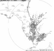
On November 1, convection increased in the complex system that absorbed the remnants of Nicholas, and the National Hurricane Center indicated the system could develop into a tropical or subtropical cyclone at any time. The low continued quickly westward, generating only sporadic convection, and crossed Florida
on November 3. After entering the Gulf of Mexico
, it turned to the west-northwest, and without organizing it made landfall in southeast Louisiana
on November 4. It continued inland, and quickly weakened over Louisiana and Mississippi
on November 5.
, as well as in portions of the northern Gulf Coast
. Gusty winds from the low produced heavy surf and rip currents along the east and west coast of Florida, and a wind gust of 35 mph (55 km/h) was recorded in Cape Canaveral
as a rainband
from the system moved ashore. The low also resulted in two to four foot (0.6 to 1.2 m) swells along the East Coast of the United States
. Overall, no damage or deaths were associated with Nicholas or the low that absorbed it.
Operationally, the National Hurricane Center
determined if the non-tropical low that absorbed Nicholas developed into a tropical or subtropical storm, it would be named Odette. In post-season analysis, the center considered classifying the system as an unnumbered tropical depression, though lack of sufficient characteristics of a tropical depression prevented the classification. If Nicholas had attained hurricane status, it would have been one of eight tropical cyclones to reach hurricane status in October in the deep tropical Atlantic since 1900.
Tropical cyclone
A tropical cyclone is a storm system characterized by a large low-pressure center and numerous thunderstorms that produce strong winds and heavy rain. Tropical cyclones strengthen when water evaporated from the ocean is released as the saturated air rises, resulting in condensation of water vapor...
in October and November of the 2003 Atlantic hurricane season
2003 Atlantic hurricane season
The 2003 Atlantic hurricane season was an active Atlantic hurricane season with tropical activity before and after the official bounds of the season – the first such occurrence in 50 years. The season produced 21 tropical cyclones, of which 16 developed into named storms; seven...
. Forming from a tropical wave
Tropical wave
Tropical waves, easterly waves, or tropical easterly waves, also known as African easterly waves in the Atlantic region, are a type of atmospheric trough, an elongated area of relatively low air pressure, oriented north to south, which move from east to west across the tropics causing areas of...
on October 13 in the central tropical Atlantic Ocean
Atlantic Ocean
The Atlantic Ocean is the second-largest of the world's oceanic divisions. With a total area of about , it covers approximately 20% of the Earth's surface and about 26% of its water surface area...
, Nicholas slowly developed due to moderate levels of wind shear throughout its lifetime. Deep convection slowly organized, and Nicholas attained a peak intensity of 70 mph (110 km/h) on October 17. After moving west-northwestward for much of its lifetime, it turned northward and weakened due to increasing shear. The storm again turned to the west and briefly restrengthened, but after turning again to the north Nicholas transitioned to an extratropical cyclone on October 24. As an extratropical storm, Nicholas executed a large loop to the west, and after moving erratically for a week and organizing into a tropical low, it was absorbed by a non-tropical low. The low continued westward, crossed Florida
Florida
Florida is a state in the southeastern United States, located on the nation's Atlantic and Gulf coasts. It is bordered to the west by the Gulf of Mexico, to the north by Alabama and Georgia and to the east by the Atlantic Ocean. With a population of 18,801,310 as measured by the 2010 census, it...
, and ultimately dissipated over the Gulf Coast of the United States
Gulf Coast of the United States
The Gulf Coast of the United States, sometimes referred to as the Gulf South, South Coast, or 3rd Coast, comprises the coasts of American states that are on the Gulf of Mexico, which includes Texas, Louisiana, Mississippi, Alabama, and Florida and are known as the Gulf States...
on November 5.
Nicholas had no impact as a tropical cyclone, and impact from the low that absorbed the storm was limited to rainfall, gusty winds, and rough surf. Nicholas extended the above average levels of tropical cyclone activity throughout the 2003 season, and was one of fourteen seasons to reach fourteen storms. The low that absorbed the storm nearly developed into a tropical cyclone, which would have been called Odette. However, moderate wind shear
Wind shear
Wind shear, sometimes referred to as windshear or wind gradient, is a difference in wind speed and direction over a relatively short distance in the atmosphere...
prevented further development.
Meteorological history
The origin of Tropical Storm Nicholas can be traced to a tropical waveTropical wave
Tropical waves, easterly waves, or tropical easterly waves, also known as African easterly waves in the Atlantic region, are a type of atmospheric trough, an elongated area of relatively low air pressure, oriented north to south, which move from east to west across the tropics causing areas of...
that moved off the coast of Africa
Africa
Africa is the world's second largest and second most populous continent, after Asia. At about 30.2 million km² including adjacent islands, it covers 6% of the Earth's total surface area and 20.4% of the total land area...
on October 9. It moved westward, and developed a broad area of low pressure
Low pressure area
A low-pressure area, or "low", is a region where the atmospheric pressure at sea level is below that of surrounding locations. Low-pressure systems form under areas of wind divergence which occur in upper levels of the troposphere. The formation process of a low-pressure area is known as...
along the wave on October 10. Convection organized around the low early on October 12 while located 800 miles (1300 km) southwest of the Cape Verde
Cape Verde
The Republic of Cape Verde is an island country, spanning an archipelago of 10 islands located in the central Atlantic Ocean, 570 kilometres off the coast of Western Africa...
islands. As upper level winds became more favorable, the system became better organized, though the circulation center initially remained located to the west of the area of heavy showers. The surface circulation of the large circulation envelope moved towards a position near the western edge of the deepest convection, and it is estimated the system developed into Tropical Depression Nineteen late on October 13 while located 1,030 miles (1,660 km) west-southwest of the Cape Verde islands.
Located within an area of moderate southwesterly wind shear
Wind shear
Wind shear, sometimes referred to as windshear or wind gradient, is a difference in wind speed and direction over a relatively short distance in the atmosphere...
, the depression was slow to organize; early on October 14, a clear center was not depicted on Infrared
Infrared
Infrared light is electromagnetic radiation with a wavelength longer than that of visible light, measured from the nominal edge of visible red light at 0.74 micrometres , and extending conventionally to 300 µm...
satellite imagery. The depression moved to the west-northwest and gradually strengthened into Tropical Storm Nicholas late on October 14 while located 1,200 miles (1,930 km) east of the Windward Islands
Windward Islands
The Windward Islands are the southern islands of the Lesser Antilles, within the West Indies.-Name and geography:The Windward Islands are called such because they were more windward to sailing ships arriving in the New World than the Leeward Islands, given that the prevailing trade winds in the...
. On October 15, deep convection became much better organized, though the center of Nicholas remained displaced from the deepest of the shower activity. Despite the shear, the storm continued to strengthen as it moved to the west-northwest, a motion caused by a mid-level ridge
Ridge (meteorology)
A ridge is an elongated region of relatively high atmospheric pressure, the opposite of a trough....
to its north. On October 16, Nicholas transitioned from a sheared, unorganized system to a more organized system, as a result of banding features and improvement in its convective pattern due to lesser amounts of vertical shear and a healthier anticyclone
Anticyclone
An anticyclone is a weather phenomenon defined by the United States' National Weather Service's glossary as "[a] large-scale circulation of winds around a central region of high atmospheric pressure, clockwise in the Northern Hemisphere, counterclockwise in the Southern Hemisphere"...
over the storm. Nicholas continued to strengthen, and attained a peak intensity of 70 mph (110 km/h) on October 17 while located 875 miles (1,410 km) east of the Leeward Islands. Dvorak estimates
Dvorak technique
The Dvorak technique is a widely used system to subjectively estimate tropical cyclone intensity based solely on visible and infrared satellite images. Several agencies issue Dvorak intensity numbers for cyclones of sufficient intensity...
suggested Nicholas potentially attained hurricane status, though microwave images of the storm showed a sheared system without any evidence of an eye feature
Eye (cyclone)
The eye is a region of mostly calm weather found at the center of strong tropical cyclones. The eye of a storm is a roughly circular area and typically 30–65 km in diameter. It is surrounded by the eyewall, a ring of towering thunderstorms where the second most severe weather of a cyclone...
.
Subtropical ridge
The subtropical ridge is a significant belt of high pressure situated around the latitudes of 30°N in the Northern Hemisphere and 30°S in the Southern Hemisphere. It is characterized by mostly calm winds, which acts to reduce air quality under its axis by causing fog overnight, and haze during...
, the storm turned to the north on October 18. Nicholas turned more to the west on October 20, and later on the winds in the storm decreased to minimal storm strength. Convection diminished greatly, though Nicholas unexpectedly re-strengthened as deep convection refired. After reaching winds of 50 mph (85 km/h), the storm again weakened due to increasing shear, and after turning to the northwest Nicholas degenerated into a tropical depression on October 23. Nicholas tracked northward in response to a break in the subtropical ridge, and on October 24, after degenerating to a remnant low pressure area
Low pressure area
A low-pressure area, or "low", is a region where the atmospheric pressure at sea level is below that of surrounding locations. Low-pressure systems form under areas of wind divergence which occur in upper levels of the troposphere. The formation process of a low-pressure area is known as...
, Nicholas lost what tropical characteristics it retained and transitioned into an extratropical cyclone. The remnant storm executed a large anticyclonic loop, resulting in a westward motion and a brief re-intensification into an extratropical storm on October 29. The storm continued to the west along a warm front
Warm front
A warm front is a density discontinuity located at the leading edge of a homogeneous warm air mass, and is typically located on the equator-facing edge of an isotherm gradient...
associated with a non-tropical low to its southwest, and executed a second anticyclonic loop to the south. On October 30, convection increased over the low-level circulation of what was left to Nicholas, and the National Hurricane Center indicated a potential for tropical or subtropical
Subtropical cyclone
A subtropical cyclone is a weather system that has some characteristics of a tropical and an extratropical cyclone. As early as the 1950s, meteorologists were unclear whether they should be characterized as tropical or extratropical cyclones. They were officially recognized by the National...
development as it moved towards warmer waters. The system executed a small cyclonic loop, and on October 31 the system organized into a tropical low. It turned westward towards a non-tropical low, and on November 1 the remnants of Nicholas was absorbed by the low.
On November 1, convection increased in the complex system that absorbed the remnants of Nicholas, and the National Hurricane Center indicated the system could develop into a tropical or subtropical cyclone at any time. The low continued quickly westward, generating only sporadic convection, and crossed Florida
Florida
Florida is a state in the southeastern United States, located on the nation's Atlantic and Gulf coasts. It is bordered to the west by the Gulf of Mexico, to the north by Alabama and Georgia and to the east by the Atlantic Ocean. With a population of 18,801,310 as measured by the 2010 census, it...
on November 3. After entering the Gulf of Mexico
Gulf of Mexico
The Gulf of Mexico is a partially landlocked ocean basin largely surrounded by the North American continent and the island of Cuba. It is bounded on the northeast, north and northwest by the Gulf Coast of the United States, on the southwest and south by Mexico, and on the southeast by Cuba. In...
, it turned to the west-northwest, and without organizing it made landfall in southeast Louisiana
Louisiana
Louisiana is a state located in the southern region of the United States of America. Its capital is Baton Rouge and largest city is New Orleans. Louisiana is the only state in the U.S. with political subdivisions termed parishes, which are local governments equivalent to counties...
on November 4. It continued inland, and quickly weakened over Louisiana and Mississippi
Mississippi
Mississippi is a U.S. state located in the Southern United States. Jackson is the state capital and largest city. The name of the state derives from the Mississippi River, which flows along its western boundary, whose name comes from the Ojibwe word misi-ziibi...
on November 5.
Impact, records, and naming
The non-tropical low that absorbed Nicholas dropped locally heavy rainfall across the Bahamas and southern FloridaFlorida
Florida is a state in the southeastern United States, located on the nation's Atlantic and Gulf coasts. It is bordered to the west by the Gulf of Mexico, to the north by Alabama and Georgia and to the east by the Atlantic Ocean. With a population of 18,801,310 as measured by the 2010 census, it...
, as well as in portions of the northern Gulf Coast
Gulf Coast of the United States
The Gulf Coast of the United States, sometimes referred to as the Gulf South, South Coast, or 3rd Coast, comprises the coasts of American states that are on the Gulf of Mexico, which includes Texas, Louisiana, Mississippi, Alabama, and Florida and are known as the Gulf States...
. Gusty winds from the low produced heavy surf and rip currents along the east and west coast of Florida, and a wind gust of 35 mph (55 km/h) was recorded in Cape Canaveral
Cape Canaveral
Cape Canaveral, from the Spanish Cabo Cañaveral, is a headland in Brevard County, Florida, United States, near the center of the state's Atlantic coast. Known as Cape Kennedy from 1963 to 1973, it lies east of Merritt Island, separated from it by the Banana River.It is part of a region known as the...
as a rainband
Rainband
A rainband is a cloud and precipitation structure associated with an area of rainfall which is significantly elongated. Rainbands can be stratiform or convective, and are generated by differences in temperature. When noted on weather radar imagery, this precipitation elongation is referred to as...
from the system moved ashore. The low also resulted in two to four foot (0.6 to 1.2 m) swells along the East Coast of the United States
East Coast of the United States
The East Coast of the United States, also known as the Eastern Seaboard, refers to the easternmost coastal states in the United States, which touch the Atlantic Ocean and stretch up to Canada. The term includes the U.S...
. Overall, no damage or deaths were associated with Nicholas or the low that absorbed it.
Operationally, the National Hurricane Center
National Hurricane Center
The National Hurricane Center , located at Florida International University in Miami, Florida, is the division of the National Weather Service responsible for tracking and predicting weather systems within the tropics between the Prime Meridian and the 140th meridian west poleward to the 30th...
determined if the non-tropical low that absorbed Nicholas developed into a tropical or subtropical storm, it would be named Odette. In post-season analysis, the center considered classifying the system as an unnumbered tropical depression, though lack of sufficient characteristics of a tropical depression prevented the classification. If Nicholas had attained hurricane status, it would have been one of eight tropical cyclones to reach hurricane status in October in the deep tropical Atlantic since 1900.
See also
- Tropical cycloneTropical cycloneA tropical cyclone is a storm system characterized by a large low-pressure center and numerous thunderstorms that produce strong winds and heavy rain. Tropical cyclones strengthen when water evaporated from the ocean is released as the saturated air rises, resulting in condensation of water vapor...
- List of storms in the 2003 Atlantic hurricane season
- Timeline of the 2003 Atlantic hurricane seasonTimeline of the 2003 Atlantic hurricane seasonThe 2003 Atlantic hurricane season was an active Atlantic hurricane season with tropical activity before and after the official bounds of the season – the first such occurrence in 50 years. The season officially began on June 1, 2003 and ended on November 30...