
.gif)
Tropical Storm Elena (1979)
Encyclopedia
Tropical Storm Elena was a weak tropical storm
that moved ashore along Texas
in the 1979 Atlantic hurricane season
. The sixth tropical storm of the season, Elena developed from a tropical wave
to the south of Louisiana
on August 29. It tracked generally west-northwest, strengthening little before making landfall on Matagorda Island
on September 1 as a minimal tropical storm; the storm quickly dissipated over land. Elena dropped moderate rainfall along its path, causing two direct deaths in Houston
from drowning; storm damage was minor, amounting to less than $10 million (1979 USD, $28 million 2007 USD). Lightning from the storm set fire to an oil supertanker in Houston, causing three indirect deaths and 13 injuries.
moved off the coast of Africa
on August 17. It tracked westward, passing through the Lesser Antilles
on August 22, and on August 27 the weak wave axis crossed through Florida
. A tropical disturbance organized along the wave axis, with ship and buoy reports indicating the development of a low-level circulation by August 29. At 2308 GMT
later that day, a Hurricane Hunters
flight reported the existence of a tropical depression; it was classified as Tropical Depression Thirteen, while located about 240 miles (390 km) south of the mouth of the Mississippi River
. With a ridge
of high pressure located over the southeastern United States
, the depression continued tracking generally westward and intensified into Tropical Storm Elena late on August 30. Elena was the sixth tropical storm of the season, as Hurricane Frederic
attained tropical storm status six hours prior to Elena.
Unfavorable northerly vertical wind shear
persisted through much of Elena's duration, which prohibited the development of convection. An approaching frontal trough
weakened the high pressure system to its north, which resulted in Elena turning northwestward toward the Texas
coastline. The storm remained poorly organized, failing to strengthen further, and on September 1 it made landfall
on Matagorda Island
as a minimal tropical storm. The cyclone rapidly weakened after moving ashore, and early on September 2 Elena degenerated into a remnant low pressure area over southeastern Texas. Trapped between two high pressure systems, the remnant mid-level circulation drifted southwestward just inland for several days before dissipating on September 6.
 As Elena was upgraded to a tropical storm, the National Hurricane Center
issued a gale warning
from Port O'Connor, Texas
to Morgan City, Louisiana
; these remained in effect until the storm moved ashore. Winds were fairly minor in association with the storm; a station in Galveston, Texas
recorded a peak wind gust of 46 mph (74 km/h). As Elena moved ashore, it produced a 3 foot (0.9 m) storm tide at Galveston and Baytown
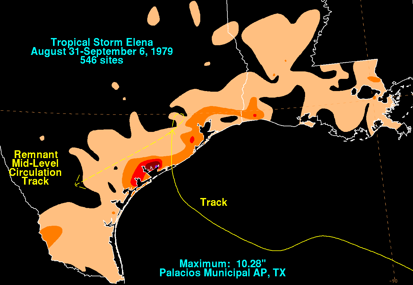
. Rainfall from the storm was generally limited to the coastline, and peaked at 10.3 inches (261 mm) at Palacios
; light rainfall also extended along the coastline of Louisiana
. Near Houston
, 4.6 inches (117 mm) of precipitation was reported, which caused two drownings from flooding. Overall storm damage was fairly minor, totaling to less than $10 million (1979 USD, $28 million 2007 USD).
At a dock owned by Shell Oil Company
in Deer Park
near Houston, a lightning bolt from thunderstorms of Elena struck the oil supertanker SS Chevron Hawaii. The lightning set a fire on the ship, which expanded and wrecked one adjacent barge and burned nearby docks. The ship was nearly split in half from the lightning strike, and oil seeped into Houston Ship Channel
for several hours. Firefighters combated the fire on the tanker in boats, but their efforts were hindered due to unsettled weather from Elena, as well as unsafe water to travel through. The fire caused three deaths and 13 injuries, and damage related to the incident totaled $27 million (1979 USD, $76 million 2007 USD).
Tropical cyclone
A tropical cyclone is a storm system characterized by a large low-pressure center and numerous thunderstorms that produce strong winds and heavy rain. Tropical cyclones strengthen when water evaporated from the ocean is released as the saturated air rises, resulting in condensation of water vapor...
that moved ashore along Texas
Texas
Texas is the second largest U.S. state by both area and population, and the largest state by area in the contiguous United States.The name, based on the Caddo word "Tejas" meaning "friends" or "allies", was applied by the Spanish to the Caddo themselves and to the region of their settlement in...
in the 1979 Atlantic hurricane season
1979 Atlantic hurricane season
The 1979 Atlantic hurricane season was the first in which the Atlantic hurricane naming list included both male and female names. It officially began on June 1 and lasted until November 30, and there was tropical cyclone activity in every month. The dates conventionally delimit the period of each...
. The sixth tropical storm of the season, Elena developed from a tropical wave
Tropical wave
Tropical waves, easterly waves, or tropical easterly waves, also known as African easterly waves in the Atlantic region, are a type of atmospheric trough, an elongated area of relatively low air pressure, oriented north to south, which move from east to west across the tropics causing areas of...
to the south of Louisiana
Louisiana
Louisiana is a state located in the southern region of the United States of America. Its capital is Baton Rouge and largest city is New Orleans. Louisiana is the only state in the U.S. with political subdivisions termed parishes, which are local governments equivalent to counties...
on August 29. It tracked generally west-northwest, strengthening little before making landfall on Matagorda Island
Matagorda Island
Matagorda Island, Spanish for "thick brush," is a 38 mile long barrier island on the Texas Gulf coast, about seven miles south of Port O'Connor, in the southernmost part of Calhoun County. The island is oriented generally northeast-southwest, with the Gulf of Mexico on the east and south, and...
on September 1 as a minimal tropical storm; the storm quickly dissipated over land. Elena dropped moderate rainfall along its path, causing two direct deaths in Houston
Houston, Texas
Houston is the fourth-largest city in the United States, and the largest city in the state of Texas. According to the 2010 U.S. Census, the city had a population of 2.1 million people within an area of . Houston is the seat of Harris County and the economic center of , which is the ...
from drowning; storm damage was minor, amounting to less than $10 million (1979 USD, $28 million 2007 USD). Lightning from the storm set fire to an oil supertanker in Houston, causing three indirect deaths and 13 injuries.
Meteorological history
A tropical waveTropical wave
Tropical waves, easterly waves, or tropical easterly waves, also known as African easterly waves in the Atlantic region, are a type of atmospheric trough, an elongated area of relatively low air pressure, oriented north to south, which move from east to west across the tropics causing areas of...
moved off the coast of Africa
Africa
Africa is the world's second largest and second most populous continent, after Asia. At about 30.2 million km² including adjacent islands, it covers 6% of the Earth's total surface area and 20.4% of the total land area...
on August 17. It tracked westward, passing through the Lesser Antilles
Lesser Antilles
The Lesser Antilles are a long, partly volcanic island arc in the Western Hemisphere. Most of its islands form the eastern boundary of the Caribbean Sea with the Atlantic Ocean, with the remainder located in the southern Caribbean just north of South America...
on August 22, and on August 27 the weak wave axis crossed through Florida
Florida
Florida is a state in the southeastern United States, located on the nation's Atlantic and Gulf coasts. It is bordered to the west by the Gulf of Mexico, to the north by Alabama and Georgia and to the east by the Atlantic Ocean. With a population of 18,801,310 as measured by the 2010 census, it...
. A tropical disturbance organized along the wave axis, with ship and buoy reports indicating the development of a low-level circulation by August 29. At 2308 GMT
Greenwich Mean Time
Greenwich Mean Time is a term originally referring to mean solar time at the Royal Observatory in Greenwich, London. It is arguably the same as Coordinated Universal Time and when this is viewed as a time zone the name Greenwich Mean Time is especially used by bodies connected with the United...
later that day, a Hurricane Hunters
Hurricane Hunters
The Hurricane Hunters are aircraft that fly into tropical cyclones in the North Atlantic Ocean and Northeastern Pacific Ocean for the specific purpose of directly measuring weather data in and around those storms. In the United States, the Air Force, Navy, and NOAA units have all participated in...
flight reported the existence of a tropical depression; it was classified as Tropical Depression Thirteen, while located about 240 miles (390 km) south of the mouth of the Mississippi River
Mississippi River
The Mississippi River is the largest river system in North America. Flowing entirely in the United States, this river rises in western Minnesota and meanders slowly southwards for to the Mississippi River Delta at the Gulf of Mexico. With its many tributaries, the Mississippi's watershed drains...
. With a ridge
Ridge (meteorology)
A ridge is an elongated region of relatively high atmospheric pressure, the opposite of a trough....
of high pressure located over the southeastern United States
United States
The United States of America is a federal constitutional republic comprising fifty states and a federal district...
, the depression continued tracking generally westward and intensified into Tropical Storm Elena late on August 30. Elena was the sixth tropical storm of the season, as Hurricane Frederic
Hurricane Frederic
Hurricane Frederic was the sixth tropical cyclone, third hurricane and second major hurricane of the 1979 Atlantic hurricane season. Frederic was the costliest hurricane to ever hit the U.S. Gulf Coast at that particular time...
attained tropical storm status six hours prior to Elena.
Unfavorable northerly vertical wind shear
Wind shear
Wind shear, sometimes referred to as windshear or wind gradient, is a difference in wind speed and direction over a relatively short distance in the atmosphere...
persisted through much of Elena's duration, which prohibited the development of convection. An approaching frontal trough
Cold front
A cold front is defined as the leading edge of a cooler mass of air, replacing a warmer mass of air.-Development of cold front:The cooler and denser air wedges under the less-dense warmer air, lifting it...
weakened the high pressure system to its north, which resulted in Elena turning northwestward toward the Texas
Texas
Texas is the second largest U.S. state by both area and population, and the largest state by area in the contiguous United States.The name, based on the Caddo word "Tejas" meaning "friends" or "allies", was applied by the Spanish to the Caddo themselves and to the region of their settlement in...
coastline. The storm remained poorly organized, failing to strengthen further, and on September 1 it made landfall
Landfall (meteorology)
Landfall is the event of a tropical cyclone or a waterspout coming onto land after being over water. When a waterspout makes landfall it is reclassified as a tornado, which can then cause damage inland...
on Matagorda Island
Matagorda Island
Matagorda Island, Spanish for "thick brush," is a 38 mile long barrier island on the Texas Gulf coast, about seven miles south of Port O'Connor, in the southernmost part of Calhoun County. The island is oriented generally northeast-southwest, with the Gulf of Mexico on the east and south, and...
as a minimal tropical storm. The cyclone rapidly weakened after moving ashore, and early on September 2 Elena degenerated into a remnant low pressure area over southeastern Texas. Trapped between two high pressure systems, the remnant mid-level circulation drifted southwestward just inland for several days before dissipating on September 6.
Impact
National Hurricane Center
The National Hurricane Center , located at Florida International University in Miami, Florida, is the division of the National Weather Service responsible for tracking and predicting weather systems within the tropics between the Prime Meridian and the 140th meridian west poleward to the 30th...
issued a gale warning
Gale warning
A gale warning is a warning issued by weather services in maritime locations about the existence of winds of gale force or above or the imminent occurrence of gales at sea...
from Port O'Connor, Texas
Port O'Connor, Texas
Port O'Connor is an unincorporated village in Calhoun County, Texas, United States, on the coastline between Galveston and Corpus Christi. The ZIP Code Tabulation Area including Port O'Connor had a population of 1,078 at the 2000 census...
to Morgan City, Louisiana
Morgan City, Louisiana
Morgan City is a city in St. Martin and St. Mary parishes in the U.S. state of Louisiana. The population was 12,404 at the 2010 census....
; these remained in effect until the storm moved ashore. Winds were fairly minor in association with the storm; a station in Galveston, Texas
Galveston, Texas
Galveston is a coastal city located on Galveston Island in the U.S. state of Texas. , the city had a total population of 47,743 within an area of...
recorded a peak wind gust of 46 mph (74 km/h). As Elena moved ashore, it produced a 3 foot (0.9 m) storm tide at Galveston and Baytown
Baytown, Texas
Baytown is a city within Harris County and partially in Chambers County in the Gulf Coast region of the U.S. state of Texas. Located within the Houston–Sugar Land–Baytown metropolitan area, it lies along both State Highway 146 and Interstate 10. As of 2010, Baytown had an population of 71,802...
. Rainfall from the storm was generally limited to the coastline, and peaked at 10.3 inches (261 mm) at Palacios
Palacios, Texas
-Demographics:As of the census of 2000, there were 5,153 people, 1,661 households, and 1,244 families residing in the city. The population density was 1,021.4 people per square mile . There were 1,976 housing units at an average density of 391.7 per square mile...
; light rainfall also extended along the coastline of Louisiana
Louisiana
Louisiana is a state located in the southern region of the United States of America. Its capital is Baton Rouge and largest city is New Orleans. Louisiana is the only state in the U.S. with political subdivisions termed parishes, which are local governments equivalent to counties...
. Near Houston
Houston, Texas
Houston is the fourth-largest city in the United States, and the largest city in the state of Texas. According to the 2010 U.S. Census, the city had a population of 2.1 million people within an area of . Houston is the seat of Harris County and the economic center of , which is the ...
, 4.6 inches (117 mm) of precipitation was reported, which caused two drownings from flooding. Overall storm damage was fairly minor, totaling to less than $10 million (1979 USD, $28 million 2007 USD).
At a dock owned by Shell Oil Company
Shell Oil Company
Shell Oil Company is the United States-based subsidiary of Royal Dutch Shell, a multinational oil company of Anglo Dutch origins, which is amongst the largest oil companies in the world. Approximately 22,000 Shell employees are based in the U.S. The head office in the U.S. is in Houston, Texas...
in Deer Park
Deer Park, Texas
Deer Park is a city in the U.S. state of Texas within the Houston–Sugar Land–Baytown metropolitan area. The city is located in Harris County and is situated in Southeast Texas. As of the 2010 U.S. Census, the population of Deer Park was 32,010....
near Houston, a lightning bolt from thunderstorms of Elena struck the oil supertanker SS Chevron Hawaii. The lightning set a fire on the ship, which expanded and wrecked one adjacent barge and burned nearby docks. The ship was nearly split in half from the lightning strike, and oil seeped into Houston Ship Channel
Houston Ship Channel
The Houston Ship Channel, located in Houston, Texas, is part of the Port of Houston—one of the United States's busiest seaports. The channel is the conduit for ocean-going vessels between the Houston-area shipyards and the Gulf of Mexico.-Overview:...
for several hours. Firefighters combated the fire on the tanker in boats, but their efforts were hindered due to unsettled weather from Elena, as well as unsafe water to travel through. The fire caused three deaths and 13 injuries, and damage related to the incident totaled $27 million (1979 USD, $76 million 2007 USD).
See also
- List of Texas hurricanes (1944-1979)
- Other tropical cyclones named ElenaHurricane Elena (disambiguation)The name Elena was used for three tropical cyclones in the Atlantic Ocean.*1965's Hurricane Elena - remained in open sea.*1979's Tropical Storm Elena - made landfall in Texas as a weak storm, causing $10 million in damage and two deaths....