
.gif)
List of Texas hurricanes (1944-1979)
Encyclopedia
The List of Texas hurricanes from 1944 to 1979 ecompasses 29 cyclones that have affected the U.S. State
of Texas
. Among the worst storms include Hurricane Beulah
in 1967, Hurricane Carla
in 1961 and Tropical Storm Amelia
in 1978.
The first storm of 1946 hit near the Texas/Louisiana border, causing no damage.
The third storm of the 1947 season made landfall in the state.
Hurricane 10 of the 1949 season made landfall in Texas after crossing in from the Pacific basin.
 The first Hurricane Alice
of 1954 dissipated over Texas. Heavy rains caused major crop damage to cotton crops, as well as 55 deaths. The next storm, Tropical Storm Barabara made landfall near Sabine Pass, Texas. An October 1954 depression caused rainfall in Texas.
Hurricane Gladys of 1955 struck 140 miles (225.3 km) south of Brownsville as a category 1 hurricane on the 5th. The rainfall total at Flour Bluff was 17.02". Corpus Christi saw 7.6" of rain in 24 hours. Tides rose to 4.5'. A circulation center rotating around the eastern periphery of the storm moved onshore on the 7th south of Baffin Bay. Locals to the area named it "Glasscock", after the oil platform 15 miles (24.1 km) east of Port Aransas that recorded winds of 83 mi/h. Winds of 60 mi/h were seen at Flour Bluff. Damage was confined to the coast.
Hurricane Audrey
made landfall near Sabine Pass, Texas
on June 27, 1957, as a 145 mi/h Category 4 hurricane.,,, Audrey's 12-foot (3.7 m) storm surge devastated Cameron, Louisiana and Sabine Pass, TX, causing $150 million in damage. Audrey was responsible for at least 390 deaths, although other sources claim the number could be over 500. Audrey is ranked as the sixth deadliest hurricane to hit the United States mainland. The next storm to hit the United States
to cause more fatalities was Hurricane Katrina in 2005. Audrey remains the earliest known category four hurricane to form in the Atlantic Basin. Like 1954, the next storm of the season, Tropical Storm Bertha, made landfall in Texas.
Tropical Storm Alma of 1958 hit northeastern Mexico 70 miles (112.7 km) south of Brownsville, Texas
. It dissipated the following day after causing one indirect death from drowning.
Ella of 1958 hit southeastern Texas
on the 6th of September, and dissipated later that day. Ella caused a total of $200,000 in damage (1958 dollars) and 37-39 deaths in Cuba
and Haiti
from drowning. In addition, Galveston
received torrential rainfall amounting to 13.6 inches (345.4 mm).
Hurricane Debra in 1959 hit between Freeport, Texas
and Galveston, Texas
as a minimal hurricane. It weakened over Texas, and dissipated over western Oklahoma
. Debra caused a total of $7 million (1959 dollars) in damage, but no fatalities.
 Tropical Storm One of 1960 hit 30 miles (48.3 km) south of Corpus Christi, Texas
as a 45 mi/h storm. The storm looped over southern Texas, dumping heavy rain over the area. It moved slowly northward, and eventually dissipated over Illinois
. Though weak, the storm caused $3.6 million in damage (1960 dollars) and 15 deaths.
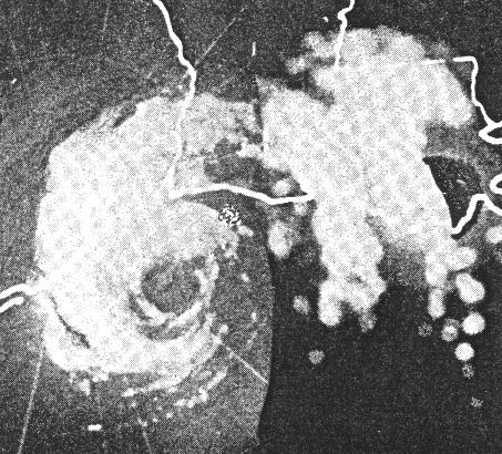
September 11, 1961: Hurricane Carla
made landfall near Port Lavaca
as a Category 4 hurricane. With an estimated central pressure of 931 mb at landfall, Carla was one of the largest and most intense hurricanes to strike the United States, and the strongest ever to hit Texas. Gusts as high as 170 mi/h were estimated at Port Lavaca. Carla killed 31 people in Texas. The low death toll is credited to what was then the largest peacetime evacuation in United States
history up until that time. One half million residents headed inland from exposed coastal areas. Carla caused a total of $325 million ($2.03 billion in 2005 USD) in damage.
 Hurricane Cindy in 1963 made landfall on High Island, Texas
. Cindy brought heavy rain to southeast Texas as it drifted southwestward over the state. The hurricane dissipated after causing $12.5 million (1963 dollars; $76 million 2005 USD) in damage and three deaths.
Tropical Storm Abby the very next year hit Matagorda, Texas
as a 65 mi/h tropical storm, dissipating the following day. Abby was a small system; its complete circulation at the surface was less than 100 mile
s (160 km) in diameter. Because of this, Abby caused only $750,000 (1964 dollars; $30.7 million 2005 USD) in damage, most of it from crop damage.
In 1967, Hurricane Beulah
made landfall just north of the mouth of the Rio Grande
as a Category 3 storm. highest sustained wind was reported as 136 MPH, recorded in South Padre Island, about 20 miles (32.2 km) north of Port Isabel. The lower Rio Grande Valley, the four county region that comprises deep south Texas, was inundated with torrential rains and strong winds. Gusts of over 100 MPH were recorded as far inland as the towns of McAllen, Edinburg, Mission, and Pharr, some fifty miles from the gulf coast. Beulah was a record tornado-producer (a record that would stand until 2004) that destroyed homes, commercial property, and inflicted serious damage on the region's agricultural industry. The Rio Grande Valley's citrus industry, based on cultivation of the famous "Ruby Red" grapefruit, was particularly hard hit. Padre Island, just off the Texas gulf coast, suffered significant devastation, and the island's sensitive ecosystem was altered by the storm. Within a 36 hour period it dropped almost 30 inches of rain in Beeville, Texas. Hurricane Beulah caused an estimated $1.1 billion (in 2000 dollars) in damage. Sources report 58-59 deaths from the storm.
In 1968, Tropical Storm Candy moved inland over southeast Texas, causing heavy flooding, crop damage, and tornadoes.
 Hurricane Celia
of 1970 made landfall in Texas. Celia killed 20 due to extreme gusts, and caused hundreds of millions of dollars in damage. The storm produced microbursts, which are rare in a tropical cyclone. The windbursts caused heavy damage across the city. In Corpus Christi, Texas
, one person was reported dead with over 460 others injured. Damage accumulated was about $1.8 billion dollars (1998 USD). In Port O'Connor, Texas
, the storm broke several wind gauges and killed four people. Along the coast, boats were pushed ashore.
Later that year, Tropical Storm Felice
made landfall in Texas
.

caused tides up to 6' in Sabine Pass in 1971, soon Hurricane Fern made landfall between Freeport, Texas
and Matagorda, Texas as a tropical storm. Damage was minimal.
made landfall in Louisiana producing heavy rainfall throughout Eastern Texas.
.
, with flooding rains, led to the deaths of 30 people in Texas in late July 1978. Later that year, Tropical Storm Debra made landfall halfway between Lake Charles, Louisiana
and Beaumont, Texas
, causing minimal damage.
produced torrential rains in both Texas
and Louisiana
when it made landfall. The highest total was reported in Alvin, Texas
where 42 inches (1,066.8 mm) of rain fell. This remains the twenty-four hour rainfall record for any location in the United States.
Later in 1979, Tropical Storm Elena made landfall near Sargent, Texas
as a weak tropical storm, rapidly deteriorating as it moved inland. It caused less than $10 million dollars (1979 USD; $28 million 2005 USD) in damage but managed to kill two people in floods.
Again in 1979, Tropical Depression 20 produced rainfall in Louisiana and Texas after hitting Brownsville.
U.S. state
A U.S. state is any one of the 50 federated states of the United States of America that share sovereignty with the federal government. Because of this shared sovereignty, an American is a citizen both of the federal entity and of his or her state of domicile. Four states use the official title of...
of Texas
Texas
Texas is the second largest U.S. state by both area and population, and the largest state by area in the contiguous United States.The name, based on the Caddo word "Tejas" meaning "friends" or "allies", was applied by the Spanish to the Caddo themselves and to the region of their settlement in...
. Among the worst storms include Hurricane Beulah
Hurricane Beulah
Hurricane Beulah was the second tropical storm, second hurricane, and only major hurricane during the 1967 Atlantic hurricane season. It tracked through the Caribbean, struck the Yucatán peninsula of Mexico as a major hurricane, and moved west-northwest into the Gulf of Mexico, briefly gaining...
in 1967, Hurricane Carla
Hurricane Carla
Hurricane Carla was one of two Category 5 tropical cyclones during the 1961 Atlantic hurricane season. It struck the Texas coast as a Category 4 hurricane, becoming one of the most powerful storms to ever strike the United States. Hurricane Carla was the second most intense storm to ever...
in 1961 and Tropical Storm Amelia
Tropical Storm Amelia (1978)
Tropical Storm Amelia was a weak, poorly-organized tropical storm that caused a severe flooding disaster in Texas during the 1978 Atlantic hurricane season. Amelia developed from a tropical wave on July 30 that entered an area of the Gulf of Mexico that was conductive for tropical cyclogenesis...
in 1978.
1945 - 1949
The second storm of 1945 hit southern Texas, causing no reported damage. The fifth hurricane of the same year made landfall near Port Aransas in central Texas as a 140 mi/h Category 4 hurricane. Towns from Freeport to Brownsville were subjected to hurricane force winds, causing around $20 million (1945 US dollars) in damages, and three deaths.The first storm of 1946 hit near the Texas/Louisiana border, causing no damage.
The third storm of the 1947 season made landfall in the state.
Hurricane 10 of the 1949 season made landfall in Texas after crossing in from the Pacific basin.
1950s
In 1950, Tropical Storm How hit the Mexican coast 150 miles (241.4 km) south of Brownsville. Damage was reported as far north as Port Aransas. Corpus Christi had gusts to 39 mi/h. Tides rose to 4' at Padre Island. Sections of highway on North Padre Island at Gulf Park were washed away.Hurricane Alice (June 1954)
Hurricane Alice was a Category 1 hurricane that struck extreme northern Mexico and southern Texas in June 1954, causing at least 55 deaths. It formed in the Bay of Campeche on June 24, and maintained its intensity as it progressed inland between Texas and Mexico...
of 1954 dissipated over Texas. Heavy rains caused major crop damage to cotton crops, as well as 55 deaths. The next storm, Tropical Storm Barabara made landfall near Sabine Pass, Texas. An October 1954 depression caused rainfall in Texas.
Hurricane Gladys of 1955 struck 140 miles (225.3 km) south of Brownsville as a category 1 hurricane on the 5th. The rainfall total at Flour Bluff was 17.02". Corpus Christi saw 7.6" of rain in 24 hours. Tides rose to 4.5'. A circulation center rotating around the eastern periphery of the storm moved onshore on the 7th south of Baffin Bay. Locals to the area named it "Glasscock", after the oil platform 15 miles (24.1 km) east of Port Aransas that recorded winds of 83 mi/h. Winds of 60 mi/h were seen at Flour Bluff. Damage was confined to the coast.
Hurricane Audrey
Hurricane Audrey
Hurricane Audrey was the first major hurricane of the 1957 Atlantic hurricane season. Audrey was the only storm to reach Category 4 status in June. A powerful hurricane, Audrey caused catastrophic damage across eastern Texas and western Louisiana. It then affected the South Central United States as...
made landfall near Sabine Pass, Texas
Sabine Pass, Texas
Sabine Pass is a neighborhood of Port Arthur, Texas, United States. It lies on the west bank of Sabine Pass, near the Louisiana border.Originally known as Sabine City, the original date of settlement of Sabine Pass is unknown, but is estimated at 1836...
on June 27, 1957, as a 145 mi/h Category 4 hurricane.,,, Audrey's 12-foot (3.7 m) storm surge devastated Cameron, Louisiana and Sabine Pass, TX, causing $150 million in damage. Audrey was responsible for at least 390 deaths, although other sources claim the number could be over 500. Audrey is ranked as the sixth deadliest hurricane to hit the United States mainland. The next storm to hit the United States
United States
The United States of America is a federal constitutional republic comprising fifty states and a federal district...
to cause more fatalities was Hurricane Katrina in 2005. Audrey remains the earliest known category four hurricane to form in the Atlantic Basin. Like 1954, the next storm of the season, Tropical Storm Bertha, made landfall in Texas.
Tropical Storm Alma of 1958 hit northeastern Mexico 70 miles (112.7 km) south of Brownsville, Texas
Brownsville, Texas
Brownsville is a city in the southernmost tip of the state of Texas, in the United States. It is located on the northern bank of the Rio Grande, directly north and across the border from Matamoros, Tamaulipas, Mexico. Brownsville is the 16th largest city in the state of Texas with a population of...
. It dissipated the following day after causing one indirect death from drowning.
Ella of 1958 hit southeastern Texas
Texas
Texas is the second largest U.S. state by both area and population, and the largest state by area in the contiguous United States.The name, based on the Caddo word "Tejas" meaning "friends" or "allies", was applied by the Spanish to the Caddo themselves and to the region of their settlement in...
on the 6th of September, and dissipated later that day. Ella caused a total of $200,000 in damage (1958 dollars) and 37-39 deaths in Cuba
Cuba
The Republic of Cuba is an island nation in the Caribbean. The nation of Cuba consists of the main island of Cuba, the Isla de la Juventud, and several archipelagos. Havana is the largest city in Cuba and the country's capital. Santiago de Cuba is the second largest city...
and Haiti
Haiti
Haiti , officially the Republic of Haiti , is a Caribbean country. It occupies the western, smaller portion of the island of Hispaniola, in the Greater Antillean archipelago, which it shares with the Dominican Republic. Ayiti was the indigenous Taíno or Amerindian name for the island...
from drowning. In addition, Galveston
Galveston, Texas
Galveston is a coastal city located on Galveston Island in the U.S. state of Texas. , the city had a total population of 47,743 within an area of...
received torrential rainfall amounting to 13.6 inches (345.4 mm).
Hurricane Debra in 1959 hit between Freeport, Texas
Freeport, Texas
Freeport is a city in Brazoria County, Texas within the Houston–Sugar Land–Baytown metropolitan area and is situated in Southeast Texas. As of the 2000 U.S...
and Galveston, Texas
Galveston, Texas
Galveston is a coastal city located on Galveston Island in the U.S. state of Texas. , the city had a total population of 47,743 within an area of...
as a minimal hurricane. It weakened over Texas, and dissipated over western Oklahoma
Oklahoma
Oklahoma is a state located in the South Central region of the United States of America. With an estimated 3,751,351 residents as of the 2010 census and a land area of 68,667 square miles , Oklahoma is the 28th most populous and 20th-largest state...
. Debra caused a total of $7 million (1959 dollars) in damage, but no fatalities.
1960s
Corpus Christi, Texas
Corpus Christi is a coastal city in the South Texas region of the U.S. state of Texas. The county seat of Nueces County, it also extends into Aransas, Kleberg, and San Patricio counties. The MSA population in 2008 was 416,376. The population was 305,215 at the 2010 census making it the...
as a 45 mi/h storm. The storm looped over southern Texas, dumping heavy rain over the area. It moved slowly northward, and eventually dissipated over Illinois
Illinois
Illinois is the fifth-most populous state of the United States of America, and is often noted for being a microcosm of the entire country. With Chicago in the northeast, small industrial cities and great agricultural productivity in central and northern Illinois, and natural resources like coal,...
. Though weak, the storm caused $3.6 million in damage (1960 dollars) and 15 deaths.
September 11, 1961: Hurricane Carla
Hurricane Carla
Hurricane Carla was one of two Category 5 tropical cyclones during the 1961 Atlantic hurricane season. It struck the Texas coast as a Category 4 hurricane, becoming one of the most powerful storms to ever strike the United States. Hurricane Carla was the second most intense storm to ever...
made landfall near Port Lavaca
Port Lavaca, Texas
Port Lavaca is a city in Calhoun County, Texas, United States. The population was 12,248 at the 2010 census. The County had a 3.6% growth which brought the county population to 21,381. The city itself is bringing in more business into the area. It is the county seat of Calhoun County...
as a Category 4 hurricane. With an estimated central pressure of 931 mb at landfall, Carla was one of the largest and most intense hurricanes to strike the United States, and the strongest ever to hit Texas. Gusts as high as 170 mi/h were estimated at Port Lavaca. Carla killed 31 people in Texas. The low death toll is credited to what was then the largest peacetime evacuation in United States
United States
The United States of America is a federal constitutional republic comprising fifty states and a federal district...
history up until that time. One half million residents headed inland from exposed coastal areas. Carla caused a total of $325 million ($2.03 billion in 2005 USD) in damage.
High Island, Texas
High Island is an unincorporated area located in the Bolivar Peninsula census-designated place, Galveston County, Texas, United States. The community is located in the extreme eastern part of the county on Bolivar Peninsula, less than one mile from Chambers County and less than two miles from...
. Cindy brought heavy rain to southeast Texas as it drifted southwestward over the state. The hurricane dissipated after causing $12.5 million (1963 dollars; $76 million 2005 USD) in damage and three deaths.
Tropical Storm Abby the very next year hit Matagorda, Texas
Matagorda, Texas
Matagorda is an unincorporated community in Matagorda County, Texas, United States. It had a population of approximately 710 in 2000. Matagorda is at the end of State Highway 60 and beginning of Farm to Market Road 2031, which runs over the Intracoastal Waterway and south to the Gulf of Mexico...
as a 65 mi/h tropical storm, dissipating the following day. Abby was a small system; its complete circulation at the surface was less than 100 mile
Mile
A mile is a unit of length, most commonly 5,280 feet . The mile of 5,280 feet is sometimes called the statute mile or land mile to distinguish it from the nautical mile...
s (160 km) in diameter. Because of this, Abby caused only $750,000 (1964 dollars; $30.7 million 2005 USD) in damage, most of it from crop damage.
In 1967, Hurricane Beulah
Hurricane Beulah
Hurricane Beulah was the second tropical storm, second hurricane, and only major hurricane during the 1967 Atlantic hurricane season. It tracked through the Caribbean, struck the Yucatán peninsula of Mexico as a major hurricane, and moved west-northwest into the Gulf of Mexico, briefly gaining...
made landfall just north of the mouth of the Rio Grande
Rio Grande
The Rio Grande is a river that flows from southwestern Colorado in the United States to the Gulf of Mexico. Along the way it forms part of the Mexico – United States border. Its length varies as its course changes...
as a Category 3 storm. highest sustained wind was reported as 136 MPH, recorded in South Padre Island, about 20 miles (32.2 km) north of Port Isabel. The lower Rio Grande Valley, the four county region that comprises deep south Texas, was inundated with torrential rains and strong winds. Gusts of over 100 MPH were recorded as far inland as the towns of McAllen, Edinburg, Mission, and Pharr, some fifty miles from the gulf coast. Beulah was a record tornado-producer (a record that would stand until 2004) that destroyed homes, commercial property, and inflicted serious damage on the region's agricultural industry. The Rio Grande Valley's citrus industry, based on cultivation of the famous "Ruby Red" grapefruit, was particularly hard hit. Padre Island, just off the Texas gulf coast, suffered significant devastation, and the island's sensitive ecosystem was altered by the storm. Within a 36 hour period it dropped almost 30 inches of rain in Beeville, Texas. Hurricane Beulah caused an estimated $1.1 billion (in 2000 dollars) in damage. Sources report 58-59 deaths from the storm.
In 1968, Tropical Storm Candy moved inland over southeast Texas, causing heavy flooding, crop damage, and tornadoes.
1970
Hurricane Celia
Hurricane Celia was the third named tropical cyclone, the second hurricane, and first major hurricane of the 1970 Atlantic hurricane season. Celia began as a tropical wave which formed off the eastern coast of Africa on July 23. The wave reached the eastern Caribbean Sea on July 28 and began to...
of 1970 made landfall in Texas. Celia killed 20 due to extreme gusts, and caused hundreds of millions of dollars in damage. The storm produced microbursts, which are rare in a tropical cyclone. The windbursts caused heavy damage across the city. In Corpus Christi, Texas
Corpus Christi, Texas
Corpus Christi is a coastal city in the South Texas region of the U.S. state of Texas. The county seat of Nueces County, it also extends into Aransas, Kleberg, and San Patricio counties. The MSA population in 2008 was 416,376. The population was 305,215 at the 2010 census making it the...
, one person was reported dead with over 460 others injured. Damage accumulated was about $1.8 billion dollars (1998 USD). In Port O'Connor, Texas
Port O'Connor, Texas
Port O'Connor is an unincorporated village in Calhoun County, Texas, United States, on the coastline between Galveston and Corpus Christi. The ZIP Code Tabulation Area including Port O'Connor had a population of 1,078 at the 2000 census...
, the storm broke several wind gauges and killed four people. Along the coast, boats were pushed ashore.
Later that year, Tropical Storm Felice
Tropical Storm Felice (1970)
Tropical Storm Felice was a mid-September tropical storm that formed during the 1970 Atlantic hurricane season. The seventh tropical cyclone of the 1970 season, Felice formed over the Bahamas as a tropical depression on September 12 and crossed southern Florida where it reached tropical storm...
made landfall in Texas
Texas
Texas is the second largest U.S. state by both area and population, and the largest state by area in the contiguous United States.The name, based on the Caddo word "Tejas" meaning "friends" or "allies", was applied by the Spanish to the Caddo themselves and to the region of their settlement in...
.
1971
Hurricane EdithHurricane Edith
Hurricane Edith was the strongest hurricane to form during the 1971 Atlantic hurricane season. It developed from a tropical wave on September 5 and quickly strengthened into a hurricane in the Caribbean Sea. Edith rapidly intensified on September 9 and made landfall on Cape Gracias a Dios as a...
caused tides up to 6' in Sabine Pass in 1971, soon Hurricane Fern made landfall between Freeport, Texas
Freeport, Texas
Freeport is a city in Brazoria County, Texas within the Houston–Sugar Land–Baytown metropolitan area and is situated in Southeast Texas. As of the 2000 U.S...
and Matagorda, Texas as a tropical storm. Damage was minimal.
1973
Tropical Storm Delia in 1973 made its first landfall on the Southeast Texas coast near Freeport, and after a loop it hit Freeport again a few days later. This became the first known tropical cyclone to hit the same area twice. Six days later, Tropical Depression Six stalled over the Freeport, Texas area from the 10th to the 12th, bringing more rain to coastal areas that had already been saturated by Tropical Storm Delia. The depression caused $15 million more in crop damages.1974
In 1974, Hurricane CarmenHurricane Carmen
Hurricane Carmen was the most intense tropical cyclone of the 1974 Atlantic hurricane season. A destructive and widespread storm, Carmen originated as a tropical disturbance that emerged from Africa toward the end of August. The wave traveled westward, spawning a tropical depression east of the...
made landfall in Louisiana producing heavy rainfall throughout Eastern Texas.
1975
Hurricane Caroline of 1975 made landfall 100 miles (160 km) south of Brownsville, TexasBrownsville, Texas
Brownsville is a city in the southernmost tip of the state of Texas, in the United States. It is located on the northern bank of the Rio Grande, directly north and across the border from Matamoros, Tamaulipas, Mexico. Brownsville is the 16th largest city in the state of Texas with a population of...
.
1978
Tropical Storm Amelia (1978)Tropical Storm Amelia (1978)
Tropical Storm Amelia was a weak, poorly-organized tropical storm that caused a severe flooding disaster in Texas during the 1978 Atlantic hurricane season. Amelia developed from a tropical wave on July 30 that entered an area of the Gulf of Mexico that was conductive for tropical cyclogenesis...
, with flooding rains, led to the deaths of 30 people in Texas in late July 1978. Later that year, Tropical Storm Debra made landfall halfway between Lake Charles, Louisiana
Lake Charles, Louisiana
Lake Charles is the fifth-largest incorporated city in the U.S. state of Louisiana, located on Lake Charles, Prien Lake, and the Calcasieu River. Located in Calcasieu Parish, a major cultural, industrial, and educational center in the southwest region of the state, and one of the most important in...
and Beaumont, Texas
Beaumont, Texas
Beaumont is a city in and county seat of Jefferson County, Texas, United States, within the Beaumont–Port Arthur Metropolitan Statistical Area. The city's population was 118,296 at the 2010 census. With Port Arthur and Orange, it forms the Golden Triangle, a major industrial area on the...
, causing minimal damage.
1979
From July 24-27, 1979, Tropical Storm ClaudetteTropical Storm Claudette (1979)
Tropical Storm Claudette was a long living tropical storm that produced heavy rain across Puerto Rico and Texas in late July 1979. The storm killed 2 people and left $1.1 billion in damage...
produced torrential rains in both Texas
Texas
Texas is the second largest U.S. state by both area and population, and the largest state by area in the contiguous United States.The name, based on the Caddo word "Tejas" meaning "friends" or "allies", was applied by the Spanish to the Caddo themselves and to the region of their settlement in...
and Louisiana
Louisiana
Louisiana is a state located in the southern region of the United States of America. Its capital is Baton Rouge and largest city is New Orleans. Louisiana is the only state in the U.S. with political subdivisions termed parishes, which are local governments equivalent to counties...
when it made landfall. The highest total was reported in Alvin, Texas
Alvin, Texas
Alvin is a city in the U.S. state of Texas within the Houston–Sugar Land–Baytown metropolitan area and Brazoria County. As of the 2000 U.S. Census, the city population was 21,413. Alvin's claim to fame is Baseball Hall of Famer Nolan Ryan, who moved with his family to the city in 1947 as...
where 42 inches (1,066.8 mm) of rain fell. This remains the twenty-four hour rainfall record for any location in the United States.
Later in 1979, Tropical Storm Elena made landfall near Sargent, Texas
Sargent, Texas
Sargent is a small unincorporated community located in the eastern corner of Matagorda County, Texas, United States.Sargent is a fishing, boating, and water sports community with a variable population, as most of its inhabitants are weekend commuters from larger cities such as Houston, Austin, and...
as a weak tropical storm, rapidly deteriorating as it moved inland. It caused less than $10 million dollars (1979 USD; $28 million 2005 USD) in damage but managed to kill two people in floods.
Again in 1979, Tropical Depression 20 produced rainfall in Louisiana and Texas after hitting Brownsville.
See also
- List of Texas hurricanes (Pre-1900)
- List of Texas hurricanes
- List of wettest known tropical cyclones affecting Texas