
.gif)
Tropical Storm Arlene (1993)
Encyclopedia
Tropical Storm Arlene was the first tropical cyclone
to make landfall
in Texas
since Hurricane Jerry
in 1989. The second tropical cyclone and first named storm of the 1993 Atlantic hurricane season
, Arlene developed from a tropical wave
in the southern Gulf of Mexico
on June 18. The depression slowly strengthened as it tracked west-northwestward and then north-northwestward across the Gulf of Mexico. After briefly accelerating, the depression intensified enough to be upgraded to Tropical Storm Arlene on June 19. Due to its proximity to land, no further strengthening occurred before Arlene made landfall over Padre Island
, Texas. Arlene dissipated slightly more than 24 hours after moving inland.
The precursor tropical wave dropped heavy rainfall in Central America. As a result, 20 fatalities occurred, all of which were from a mudslide in El Salvador
. There were also reports of significant flooding in Mexico
, which affected seven states. In Texas, Arlene also dropped heavy rainfall, with some areas receiving more than 10 inches (254 mm) of precipitation. More than 600 houses and 12 businesses in Texas reported flood damage. The outerbands of Arlene also caused heavy rainfall in Louisiana
, Mississippi
, and Arkansas
, as well as light precipitation in Oklahoma
. Although no damage or fatalities were reported in those states. Overall, Arlene caused 29 fatalities and $55 million (1993 USD) in damage.
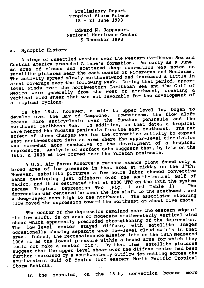
was detected on satellite images in the Caribbean Sea
near the coasts of Honduras
and Nicaragua
on June 9. The system moved westward over other Central America
n countries, most notably, El Salvador
. Initially, strong wind shear
from the west and northwest prohibited the system from strengthening as it moved into the Gulf of Mexico
. On June 16 the tropical wave interacted with an upper-level low which caused some inaccuracies in the forecast. The data produced by the National Hurricane Center
indicates that an 1008 mbar low formed over the Yucatán Peninsula
. But when a reconnaissance hurricane hunter aircraft flew in, they only found a broad area of low pressure, with no closed or low level circulation, despite the fact that satellite photo shows the system developing very well.
However, only a few hours later satellite photos also showed some convective bands from the system, so it was declared a tropical depression on June 18, Tropical Depression Two to be more specific. The center of the storm was south of a low pressure system to the north and that low forced the depression to move west-northwest. During another flight into the storm, the hurricane hunter crews reported a 1006 mbar reading but could not get an accurate fix. On June 19, a comma shaped band of thunderstorms formed around the center this caused slightly strengthening and further organization. The National Hurricane Center upgraded the depression to a tropical storm on that same day at 1200 UTC and new tropical storm received the name Arlene, therefore it was reclassified as Tropical Storm Arlene. Arlene moved northwestward at 2 to 3 mph (3.2 to 4.8 km/h) before nearly stalling because of a frontal system passing by. On June 20, Tropical Storm Arlene made landfall over Padre Island
, Texas
as a minimal tropical storm, the location of the center where it struck land was about 90 miles (144.8 km) to south of Corpus Christi
. Tropical Storm Arlene quickly weakened to a depression shortly after landfall. The remnants of the storm was tracked over the lower Rio Grande
valley of southern Texas and northeastern Mexico
.
) in damage.
 The tropical wave
that became Arlene brought heavy rains across Central America
for several days. The rains from the tropical wave
caused a landslide that left 20 people dead in El Salvador
.
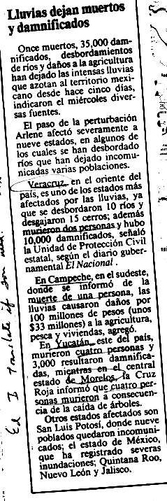
Heavy rainfall was also reported in Mexico. As a result, flooding from Arlene caused five fatalities and $33 million dollars (1993 USD
) in damage. The states of Veracruz
, Campeche
, Yucatán
, San Luis Potosí
, Quintana Roo
, Nuevo León
, Jalisco
were affected by the floods. http://www.nhc.noaa.gov/archive/storm_wallets/atlantic/atl1993/arlene/news/mexunkp1.gif
to Matagorda, Texas
on June 19, which was discontinued 24 hours later.
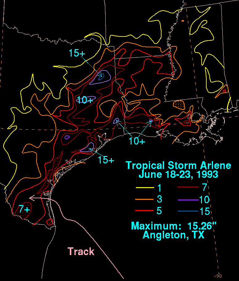
In Texas, Arlene dropped heavy rain, the highest was 326.4 mm in Henderson
. Rainfall ranging from 9-11 inches were reported in other parts of Texas. In addition, a funnel cloud
was reported near Corpus Christi
but never touched the ground. The rainfall from Arlene caused numerous reports of flooding. In Wallicy County, flooding damaged over 400 homes and 12 businesses which totaled up to $1 million dollars (1993 USD
). 200 homes in Starr County were also damaged. A storm tide
from Arlene caused minimal beach erosion along the Texas/Louisiana
coast.
In Louisiana
, Arlene's outer rainbands dropped 7-10 inches of rain across the southwestern part of the state. However there were no reports of damage.
Tropical cyclone
A tropical cyclone is a storm system characterized by a large low-pressure center and numerous thunderstorms that produce strong winds and heavy rain. Tropical cyclones strengthen when water evaporated from the ocean is released as the saturated air rises, resulting in condensation of water vapor...
to make landfall
Landfall (meteorology)
Landfall is the event of a tropical cyclone or a waterspout coming onto land after being over water. When a waterspout makes landfall it is reclassified as a tornado, which can then cause damage inland...
in Texas
Texas
Texas is the second largest U.S. state by both area and population, and the largest state by area in the contiguous United States.The name, based on the Caddo word "Tejas" meaning "friends" or "allies", was applied by the Spanish to the Caddo themselves and to the region of their settlement in...
since Hurricane Jerry
Hurricane Jerry (1989)
Hurricane Jerry was the tenth named storm and the sixth and final hurricane of the 1989 Atlantic hurricane season. Jerry was also the fourth U.S. landfalling storm and the third storm to strike Texas during the 1989 season; the two previous storms were Allison in June and Chantal in August. When it...
in 1989. The second tropical cyclone and first named storm of the 1993 Atlantic hurricane season
1993 Atlantic hurricane season
The 1993 Atlantic hurricane season was a period in the annual formation of tropical cyclones. It officially began on June 1, 1993, and lasted until November 30, 1993. These dates conventionally delimit the period of each year when most tropical cyclones form in the Atlantic basin...
, Arlene developed from a tropical wave
Tropical wave
Tropical waves, easterly waves, or tropical easterly waves, also known as African easterly waves in the Atlantic region, are a type of atmospheric trough, an elongated area of relatively low air pressure, oriented north to south, which move from east to west across the tropics causing areas of...
in the southern Gulf of Mexico
Gulf of Mexico
The Gulf of Mexico is a partially landlocked ocean basin largely surrounded by the North American continent and the island of Cuba. It is bounded on the northeast, north and northwest by the Gulf Coast of the United States, on the southwest and south by Mexico, and on the southeast by Cuba. In...
on June 18. The depression slowly strengthened as it tracked west-northwestward and then north-northwestward across the Gulf of Mexico. After briefly accelerating, the depression intensified enough to be upgraded to Tropical Storm Arlene on June 19. Due to its proximity to land, no further strengthening occurred before Arlene made landfall over Padre Island
Padre Island
Padre Island is part of the U.S. state of Texas. The island is located on Texas' southern coast of the Gulf of Mexico and is famous for its white sandy beaches at the south end...
, Texas. Arlene dissipated slightly more than 24 hours after moving inland.
The precursor tropical wave dropped heavy rainfall in Central America. As a result, 20 fatalities occurred, all of which were from a mudslide in El Salvador
El Salvador
El Salvador or simply Salvador is the smallest and the most densely populated country in Central America. The country's capital city and largest city is San Salvador; Santa Ana and San Miguel are also important cultural and commercial centers in the country and in all of Central America...
. There were also reports of significant flooding in Mexico
Mexico
The United Mexican States , commonly known as Mexico , is a federal constitutional republic in North America. It is bordered on the north by the United States; on the south and west by the Pacific Ocean; on the southeast by Guatemala, Belize, and the Caribbean Sea; and on the east by the Gulf of...
, which affected seven states. In Texas, Arlene also dropped heavy rainfall, with some areas receiving more than 10 inches (254 mm) of precipitation. More than 600 houses and 12 businesses in Texas reported flood damage. The outerbands of Arlene also caused heavy rainfall in Louisiana
Louisiana
Louisiana is a state located in the southern region of the United States of America. Its capital is Baton Rouge and largest city is New Orleans. Louisiana is the only state in the U.S. with political subdivisions termed parishes, which are local governments equivalent to counties...
, Mississippi
Mississippi
Mississippi is a U.S. state located in the Southern United States. Jackson is the state capital and largest city. The name of the state derives from the Mississippi River, which flows along its western boundary, whose name comes from the Ojibwe word misi-ziibi...
, and Arkansas
Arkansas
Arkansas is a state located in the southern region of the United States. Its name is an Algonquian name of the Quapaw Indians. Arkansas shares borders with six states , and its eastern border is largely defined by the Mississippi River...
, as well as light precipitation in Oklahoma
Oklahoma
Oklahoma is a state located in the South Central region of the United States of America. With an estimated 3,751,351 residents as of the 2010 census and a land area of 68,667 square miles , Oklahoma is the 28th most populous and 20th-largest state...
. Although no damage or fatalities were reported in those states. Overall, Arlene caused 29 fatalities and $55 million (1993 USD) in damage.
Meteorological history
A tropical waveTropical wave
Tropical waves, easterly waves, or tropical easterly waves, also known as African easterly waves in the Atlantic region, are a type of atmospheric trough, an elongated area of relatively low air pressure, oriented north to south, which move from east to west across the tropics causing areas of...
was detected on satellite images in the Caribbean Sea
Caribbean Sea
The Caribbean Sea is a sea of the Atlantic Ocean located in the tropics of the Western hemisphere. It is bounded by Mexico and Central America to the west and southwest, to the north by the Greater Antilles, and to the east by the Lesser Antilles....
near the coasts of Honduras
Honduras
Honduras is a republic in Central America. It was previously known as Spanish Honduras to differentiate it from British Honduras, which became the modern-day state of Belize...
and Nicaragua
Nicaragua
Nicaragua is the largest country in the Central American American isthmus, bordered by Honduras to the north and Costa Rica to the south. The country is situated between 11 and 14 degrees north of the Equator in the Northern Hemisphere, which places it entirely within the tropics. The Pacific Ocean...
on June 9. The system moved westward over other Central America
Central America
Central America is the central geographic region of the Americas. It is the southernmost, isthmian portion of the North American continent, which connects with South America on the southeast. When considered part of the unified continental model, it is considered a subcontinent...
n countries, most notably, El Salvador
El Salvador
El Salvador or simply Salvador is the smallest and the most densely populated country in Central America. The country's capital city and largest city is San Salvador; Santa Ana and San Miguel are also important cultural and commercial centers in the country and in all of Central America...
. Initially, strong wind shear
Wind shear
Wind shear, sometimes referred to as windshear or wind gradient, is a difference in wind speed and direction over a relatively short distance in the atmosphere...
from the west and northwest prohibited the system from strengthening as it moved into the Gulf of Mexico
Gulf of Mexico
The Gulf of Mexico is a partially landlocked ocean basin largely surrounded by the North American continent and the island of Cuba. It is bounded on the northeast, north and northwest by the Gulf Coast of the United States, on the southwest and south by Mexico, and on the southeast by Cuba. In...
. On June 16 the tropical wave interacted with an upper-level low which caused some inaccuracies in the forecast. The data produced by the National Hurricane Center
National Hurricane Center
The National Hurricane Center , located at Florida International University in Miami, Florida, is the division of the National Weather Service responsible for tracking and predicting weather systems within the tropics between the Prime Meridian and the 140th meridian west poleward to the 30th...
indicates that an 1008 mbar low formed over the Yucatán Peninsula
Yucatán Peninsula
The Yucatán Peninsula, in southeastern Mexico, separates the Caribbean Sea from the Gulf of Mexico, with the northern coastline on the Yucatán Channel...
. But when a reconnaissance hurricane hunter aircraft flew in, they only found a broad area of low pressure, with no closed or low level circulation, despite the fact that satellite photo shows the system developing very well.
However, only a few hours later satellite photos also showed some convective bands from the system, so it was declared a tropical depression on June 18, Tropical Depression Two to be more specific. The center of the storm was south of a low pressure system to the north and that low forced the depression to move west-northwest. During another flight into the storm, the hurricane hunter crews reported a 1006 mbar reading but could not get an accurate fix. On June 19, a comma shaped band of thunderstorms formed around the center this caused slightly strengthening and further organization. The National Hurricane Center upgraded the depression to a tropical storm on that same day at 1200 UTC and new tropical storm received the name Arlene, therefore it was reclassified as Tropical Storm Arlene. Arlene moved northwestward at 2 to 3 mph (3.2 to 4.8 km/h) before nearly stalling because of a frontal system passing by. On June 20, Tropical Storm Arlene made landfall over Padre Island
Padre Island
Padre Island is part of the U.S. state of Texas. The island is located on Texas' southern coast of the Gulf of Mexico and is famous for its white sandy beaches at the south end...
, Texas
Texas
Texas is the second largest U.S. state by both area and population, and the largest state by area in the contiguous United States.The name, based on the Caddo word "Tejas" meaning "friends" or "allies", was applied by the Spanish to the Caddo themselves and to the region of their settlement in...
as a minimal tropical storm, the location of the center where it struck land was about 90 miles (144.8 km) to south of Corpus Christi
Corpus Christi, Texas
Corpus Christi is a coastal city in the South Texas region of the U.S. state of Texas. The county seat of Nueces County, it also extends into Aransas, Kleberg, and San Patricio counties. The MSA population in 2008 was 416,376. The population was 305,215 at the 2010 census making it the...
. Tropical Storm Arlene quickly weakened to a depression shortly after landfall. The remnants of the storm was tracked over the lower Rio Grande
Rio Grande
The Rio Grande is a river that flows from southwestern Colorado in the United States to the Gulf of Mexico. Along the way it forms part of the Mexico – United States border. Its length varies as its course changes...
valley of southern Texas and northeastern Mexico
Mexico
The United Mexican States , commonly known as Mexico , is a federal constitutional republic in North America. It is bordered on the north by the United States; on the south and west by the Pacific Ocean; on the southeast by Guatemala, Belize, and the Caribbean Sea; and on the east by the Gulf of...
.
Preparations and Impact
As Arlene was a weak tropical cyclone, minimal damage resulted from high winds. However, much of the damage and fatalities from Arlene were as a result of flooding. Overall, Arlene left 29 people dead and $55 million (1993 USDUnited States dollar
The United States dollar , also referred to as the American dollar, is the official currency of the United States of America. It is divided into 100 smaller units called cents or pennies....
) in damage.
Latin America
Tropical wave
Tropical waves, easterly waves, or tropical easterly waves, also known as African easterly waves in the Atlantic region, are a type of atmospheric trough, an elongated area of relatively low air pressure, oriented north to south, which move from east to west across the tropics causing areas of...
that became Arlene brought heavy rains across Central America
Central America
Central America is the central geographic region of the Americas. It is the southernmost, isthmian portion of the North American continent, which connects with South America on the southeast. When considered part of the unified continental model, it is considered a subcontinent...
for several days. The rains from the tropical wave
Tropical wave
Tropical waves, easterly waves, or tropical easterly waves, also known as African easterly waves in the Atlantic region, are a type of atmospheric trough, an elongated area of relatively low air pressure, oriented north to south, which move from east to west across the tropics causing areas of...
caused a landslide that left 20 people dead in El Salvador
El Salvador
El Salvador or simply Salvador is the smallest and the most densely populated country in Central America. The country's capital city and largest city is San Salvador; Santa Ana and San Miguel are also important cultural and commercial centers in the country and in all of Central America...
.
Heavy rainfall was also reported in Mexico. As a result, flooding from Arlene caused five fatalities and $33 million dollars (1993 USD
United States dollar
The United States dollar , also referred to as the American dollar, is the official currency of the United States of America. It is divided into 100 smaller units called cents or pennies....
) in damage. The states of Veracruz
Veracruz
Veracruz, formally Veracruz de Ignacio de la Llave officially Estado Libre y Soberano de Veracruz de Ignacio de la Llave , is one of the 31 states that, along with the Federal District, comprise the 32 federative entities of Mexico. It is divided in 212 municipalities and its capital city is...
, Campeche
Campeche
Campeche is one of the 31 states which, with the Federal District, comprise the 32 Federal Entities of Mexico. Located in Southeast Mexico, it is bordered by the states of Yucatán to the north east, Quintana Roo to the east, and Tabasco to the south west...
, Yucatán
Yucatán
Yucatán officially Estado Libre y Soberano de Yucatán is one of the 31 states which, with the Federal District, comprise the 32 Federal Entities of Mexico. It is divided in 106 municipalities and its capital city is Mérida....
, San Luis Potosí
San Luis Potosí
San Luis Potosí officially Estado Libre y Soberano de San Luis Potosí is one of the 31 states which, with the Federal District, comprise the 32 Federal Entities of Mexico. It is divided in 58 municipalities and its capital city is San Luis Potosí....
, Quintana Roo
Quintana Roo
Quintana Roo officially Estado Libre y Soberano de Quintana Roo is one of the 31 states which, with the Federal District, comprise the 32 Federal Entities of Mexico. It is divided in 10 municipalities and its capital city is Chetumal....
, Nuevo León
Nuevo León
Nuevo León It is located in Northeastern Mexico. It is bordered by the states of Tamaulipas to the north and east, San Luis Potosí to the south, and Coahuila to the west. To the north, Nuevo León has a 15 kilometer stretch of the U.S.-Mexico border adjacent to the U.S...
, Jalisco
Jalisco
Jalisco officially Estado Libre y Soberano de Jalisco is one of the 31 states which, with the Federal District, comprise the 32 Federal Entities of Mexico. It is located in Western Mexico and divided in 125 municipalities and its capital city is Guadalajara.It is one of the more important states...
were affected by the floods. http://www.nhc.noaa.gov/archive/storm_wallets/atlantic/atl1993/arlene/news/mexunkp1.gif
United States
Because it was a relatively fast moving system, there was few warnings put into effect in advance of Tropical Storm Arlene. The only warning from the National Hurricane Center was a tropical storm warning in effect from BrownsvilleBrownsville, Texas
Brownsville is a city in the southernmost tip of the state of Texas, in the United States. It is located on the northern bank of the Rio Grande, directly north and across the border from Matamoros, Tamaulipas, Mexico. Brownsville is the 16th largest city in the state of Texas with a population of...
to Matagorda, Texas
Matagorda, Texas
Matagorda is an unincorporated community in Matagorda County, Texas, United States. It had a population of approximately 710 in 2000. Matagorda is at the end of State Highway 60 and beginning of Farm to Market Road 2031, which runs over the Intracoastal Waterway and south to the Gulf of Mexico...
on June 19, which was discontinued 24 hours later.
In Texas, Arlene dropped heavy rain, the highest was 326.4 mm in Henderson
Henderson, Texas
Henderson is a city in Rusk County, Texas, United States. The population was 11,273 at the 2000 census. It is the county seat of Rusk County...
. Rainfall ranging from 9-11 inches were reported in other parts of Texas. In addition, a funnel cloud
Funnel cloud
A funnel cloud is a funnel-shaped cloud of condensed water droplets, associated with a rotating column of wind and extending from the base of a cloud but not reaching the ground or a water surface. A funnel cloud is usually visible as a cone-shaped or needle like protuberance from the main cloud...
was reported near Corpus Christi
Corpus Christi, Texas
Corpus Christi is a coastal city in the South Texas region of the U.S. state of Texas. The county seat of Nueces County, it also extends into Aransas, Kleberg, and San Patricio counties. The MSA population in 2008 was 416,376. The population was 305,215 at the 2010 census making it the...
but never touched the ground. The rainfall from Arlene caused numerous reports of flooding. In Wallicy County, flooding damaged over 400 homes and 12 businesses which totaled up to $1 million dollars (1993 USD
United States dollar
The United States dollar , also referred to as the American dollar, is the official currency of the United States of America. It is divided into 100 smaller units called cents or pennies....
). 200 homes in Starr County were also damaged. A storm tide
Storm tide
A storm tide is a tide with a high flood period caused by a storm. Storm tides can be a severe danger to the coast and the people living along the coast. The water level can rise to more than 5 meters above the normal tide....
from Arlene caused minimal beach erosion along the Texas/Louisiana
Louisiana
Louisiana is a state located in the southern region of the United States of America. Its capital is Baton Rouge and largest city is New Orleans. Louisiana is the only state in the U.S. with political subdivisions termed parishes, which are local governments equivalent to counties...
coast.
In Louisiana
Louisiana
Louisiana is a state located in the southern region of the United States of America. Its capital is Baton Rouge and largest city is New Orleans. Louisiana is the only state in the U.S. with political subdivisions termed parishes, which are local governments equivalent to counties...
, Arlene's outer rainbands dropped 7-10 inches of rain across the southwestern part of the state. However there were no reports of damage.