

Tropical Storm Aere (2011)
Encyclopedia
Tropical Storm Aere was a mild tropical storm that affected eastern Philippines and southern Japan. It was the first named storm
of the 2011 Pacific typhoon season
. Aere is the Marshallese
word for storm.
In the Philippines, Aere brought very to very heavy rainfall triggering landslides and floods knocking out power in several areas across Luzon. More than 50 flights were canceled or diverted because of the bad weather conditions and President Benigno Aquino III delayed his flight home from a summit in Indonesia by a day. The coastguards have stopped smaller boats from leaving ports in Catanduanes and surrounding areas, leaving 1,379 people stranded. More than 7,200 hectares (17,800 acres - 27 square miles) of rice, corn and high-value crops costing more than 118 million pesos ($2.7 million) were destroyed or damaged. At least 35 people have been killed and two more are missing as a result of Aere. Agricultural losses are estimated at PHP1.37 billion (US$31.7 million).
Island. On that same day, the low pressure starts to strengthen rapidly with improved LLCC, tightly–wrapped shallow convective banding and a well–defined center. On the next day the low pressure starts to move northwest in general direction to the seas east of Philippine Islands. However it remained almost stationary by afternoon due to the influence of high pressure that located in the northeast of the system. By that time, its LLCC starts to become elongated and the system was also located in favorable sea surface temperatures with low vertical wind shear. Later of that day, its LLCC starts to consolidate again and the system starts to move northwest slowly, whilst the Japan Meteorological Agency
upgraded the system into a tropical depression In the afternoon of May 6, Joint Typhoon Warning Center
upgraded the low pressure into a tropical depression. In the same evening, PAGASA upgraded the low pressure into a tropical depression and assigned its local name 'Bebeng'. In the afternoon of May 7, JMA
upgraded the tropical depression to a tropical storm, and assigned the name 'Aere'. During the early morning of May 12, the JMA
downgraded Aere to a tropical depression while south of Kyushu Island.
and Visayas
. The Philippine National Police were directed to continuously report the events to the NDRRMC as it happened. The Department of Health also alerted all the hospitals in the storm prone regions and asked them to sat in continuous coordination with PAGASA. Soon, the PDRRMC initiated evacuations across the Albay
province with a population of 63,964 residing in 152 Barangay
s already evacuated as a pre-emptive measure. Also, the Armed Forces of the Philippines
(AFP) deployed several assault vehicles and military personnel to closely monitor the situation across the nation and to haul rice for relief operations.
issued a sea warning and informed residents on the eastern and southern parts of the island-nation about the torrential rain that Aere may bring. The Central Weather Bureau in Taiwan warned all ships in the Bashi Channel off the southern coast to brace for the storm reporting that the heavy rain may hit eastern and southern Taiwan triggering landslides and flooding.
bringing very to very heavy rainfall across the nation. Around 210 passengers in the port of Lucena bound for Marinduque
and 125 passengers in the port of Romblon
bound for San Fernando, Romblon
were stranded after their ships were cancelled due to heavy rains and rough sea conditions caused by the storm. More than 100,000 villagers fled from towns threatened by landslides. Aere triggered landslides and floods knocking out power in several areas across Luzon. Thousands were helped to flee from their farms around Mayon volcano in Albay procinve, which was threatened by landslides and heavy rains that have resulted in extensive flooding after the storm. A resident in Sorsogon
province who was one of the victims expressed views on the storm, saying "The floods were so deep, they went past the head". More than 50 flights were canceled or diverted because of the bad weather conditions caused by Aere. President Benigno Aquino III
delayed his flight home from a summit in Indonesia by a day due to the bad weather. The Disaster officials advised several villagers in the archipelago's agricultural regions situated in the north to stay prepared for landslides and flash floods after heavy rains poured by the storm. The coastguards have stopped smaller boats from leaving ports in Catanduanes
and surrounding areas, leaving 1,379 people stranded after the NDRRMC's announcement that the security at coasts must be tightened. More than 7,200 hectares (17,800 acres - 27 square miles) of rice, corn and high-value crops costing more than 118 million pesos ($2.7 million) were destroyed or damaged. According to the National Disaster Risk Reduction and Management Council, at least 35 people have been killed and two more are missing as a result of Aere. Agricultural losses are estimated at PHP
1.37 billion (US$
31.7 million). Widespread flooding and landslides damaged homes, blocked off roads and severed communications. In Catarman, Northern Samar
, 377.4 mm (14.9 in) of rain fell in just 24 hours, resulted in significant flash flooding.
Tropical cyclone naming
Tropical cyclones have officially been named since 1945 and are named for a variety of reasons, which include to facilitate communications between forecasters and the public when forecasts, watches, and warnings are issued. Names also reduce confusion about what storm is being described, as more...
of the 2011 Pacific typhoon season
2011 Pacific typhoon season
The 2011 Pacific typhoon season was the time of the year in which tropical cyclones form in the Western Pacific Ocean. The season ran throughout 2011 with most tropical cyclones forming between May and November. The scope of this article is limited to the Pacific Ocean to the north of the equator...
. Aere is the Marshallese
Marshallese language
The Marshallese language is a Malayo-Polynesian language of the Marshall Islands, and the principal language of the country...
word for storm.
In the Philippines, Aere brought very to very heavy rainfall triggering landslides and floods knocking out power in several areas across Luzon. More than 50 flights were canceled or diverted because of the bad weather conditions and President Benigno Aquino III delayed his flight home from a summit in Indonesia by a day. The coastguards have stopped smaller boats from leaving ports in Catanduanes and surrounding areas, leaving 1,379 people stranded. More than 7,200 hectares (17,800 acres - 27 square miles) of rice, corn and high-value crops costing more than 118 million pesos ($2.7 million) were destroyed or damaged. At least 35 people have been killed and two more are missing as a result of Aere. Agricultural losses are estimated at PHP1.37 billion (US$31.7 million).
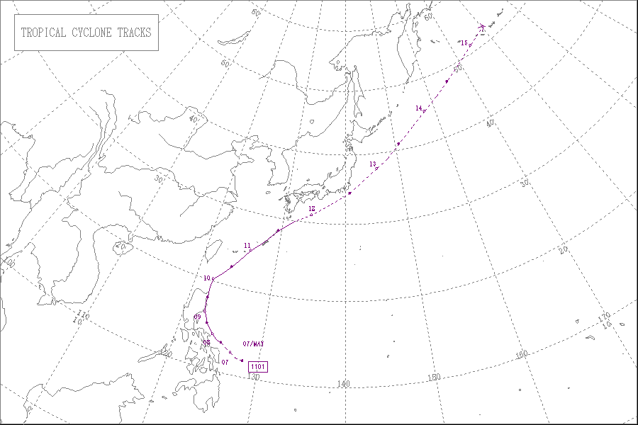
Meteorological history
Early of May 4, an area of low pressure formed about 140 km (85 mi) to the west of PalauPalau
Palau , officially the Republic of Palau , is an island nation in the Pacific Ocean, east of the Philippines and south of Tokyo. In 1978, after three decades as being part of the United Nations trusteeship, Palau chose independence instead of becoming part of the Federated States of Micronesia, a...
Island. On that same day, the low pressure starts to strengthen rapidly with improved LLCC, tightly–wrapped shallow convective banding and a well–defined center. On the next day the low pressure starts to move northwest in general direction to the seas east of Philippine Islands. However it remained almost stationary by afternoon due to the influence of high pressure that located in the northeast of the system. By that time, its LLCC starts to become elongated and the system was also located in favorable sea surface temperatures with low vertical wind shear. Later of that day, its LLCC starts to consolidate again and the system starts to move northwest slowly, whilst the Japan Meteorological Agency
Japan Meteorological Agency
The or JMA, is the Japanese government's weather service. Charged with gathering and reporting weather data and forecasts in Japan, it is a semi-autonomous part of the Ministry of Land, Infrastructure and Transport...
upgraded the system into a tropical depression In the afternoon of May 6, Joint Typhoon Warning Center
Joint Typhoon Warning Center
The Joint Typhoon Warning Center is a joint United States Navy – United States Air Force task force located at the Naval Maritime Forecast Center in Pearl Harbor, Hawaii...
upgraded the low pressure into a tropical depression. In the same evening, PAGASA upgraded the low pressure into a tropical depression and assigned its local name 'Bebeng'. In the afternoon of May 7, JMA
Japan Meteorological Agency
The or JMA, is the Japanese government's weather service. Charged with gathering and reporting weather data and forecasts in Japan, it is a semi-autonomous part of the Ministry of Land, Infrastructure and Transport...
upgraded the tropical depression to a tropical storm, and assigned the name 'Aere'. During the early morning of May 12, the JMA
Japan Meteorological Agency
The or JMA, is the Japanese government's weather service. Charged with gathering and reporting weather data and forecasts in Japan, it is a semi-autonomous part of the Ministry of Land, Infrastructure and Transport...
downgraded Aere to a tropical depression while south of Kyushu Island.
Philippines
Almost immediately after the PAGASA started monitoring the system, the NDRRMC raised storm warning signal 1 over the areas of LuzonLuzon
Luzon is the largest island in the Philippines. It is located in the northernmost region of the archipelago, and is also the name for one of the three primary island groups in the country centered on the Island of Luzon...
and Visayas
Visayas
The Visayas or Visayan Islands and locally known as Kabisay-an gid, is one of the three principal geographical divisions of the Philippines, along with Mindanao and Luzon. It consists of several islands, primarily surrounding the Visayan Sea, although the Visayas are considered the northeast...
. The Philippine National Police were directed to continuously report the events to the NDRRMC as it happened. The Department of Health also alerted all the hospitals in the storm prone regions and asked them to sat in continuous coordination with PAGASA. Soon, the PDRRMC initiated evacuations across the Albay
Albay
Albay is a province of the Philippines located in the Bicol Region in Luzon. Its capital is Legazpi City and the province borders Camarines Sur to the north and Sorsogon to the south. Also to the northeast is Lagonoy Gulf....
province with a population of 63,964 residing in 152 Barangay
Barangay
A barangay is the smallest administrative division in the Philippines and is the native Filipino term for a village, district or ward...
s already evacuated as a pre-emptive measure. Also, the Armed Forces of the Philippines
Armed Forces of the Philippines
The Armed Forces of the Philippines is composed of the Philippine Army, Philippine Navy and Philippine Air Force...
(AFP) deployed several assault vehicles and military personnel to closely monitor the situation across the nation and to haul rice for relief operations.
Taiwan
Officials in TaiwanTaiwan
Taiwan , also known, especially in the past, as Formosa , is the largest island of the same-named island group of East Asia in the western Pacific Ocean and located off the southeastern coast of mainland China. The island forms over 99% of the current territory of the Republic of China following...
issued a sea warning and informed residents on the eastern and southern parts of the island-nation about the torrential rain that Aere may bring. The Central Weather Bureau in Taiwan warned all ships in the Bashi Channel off the southern coast to brace for the storm reporting that the heavy rain may hit eastern and southern Taiwan triggering landslides and flooding.
Philippines
Early on May 8, Aere made landfall over Northern CatanduanesCatanduanes
Catanduanes is an island province of the Philippines located in the Bicol Region in Luzon. Its capital is Virac and the province lies to the east of Camarines Sur across Maqueda Channel. As of 2007, the population of the province is 232,757 people.-Etymology:"Isla de Cobos" was Catanduanes' first...
bringing very to very heavy rainfall across the nation. Around 210 passengers in the port of Lucena bound for Marinduque
Marinduque
In 1945, combined American and Philippine Commonwealth troops attacked from the Japanese Troops liberated to the Battle of Marinduque in the Second World War.-Archaeology:...
and 125 passengers in the port of Romblon
Romblon
Romblon is an island province of the Philippines located in the MIMAROPA region. It lies south of Marinduque and Quezon, east of Mindoro, north of Aklan and Capiz, and west of Masbate. Its capital is also named Romblon....
bound for San Fernando, Romblon
San Fernando, Romblon
San Fernando is a 4th class municipality in the province of Romblon, Philippines. According to the 2000 census, it has a population of 21,214 people in 4,159 households.-Barangays:San Fernando is politically subdivided into 12 barangays.* Agtiwa...
were stranded after their ships were cancelled due to heavy rains and rough sea conditions caused by the storm. More than 100,000 villagers fled from towns threatened by landslides. Aere triggered landslides and floods knocking out power in several areas across Luzon. Thousands were helped to flee from their farms around Mayon volcano in Albay procinve, which was threatened by landslides and heavy rains that have resulted in extensive flooding after the storm. A resident in Sorsogon
Sorsogon
Sorsogon is a province of the Philippines located in the Bicol Region; it is the southernmost province in Luzon and is subdivided into fourteen municipalities and one city. Its capital is Sorsogon City and borders the province of Albay to the north...
province who was one of the victims expressed views on the storm, saying "The floods were so deep, they went past the head". More than 50 flights were canceled or diverted because of the bad weather conditions caused by Aere. President Benigno Aquino III
Benigno Aquino III
Benigno Simeon Cojuangco Aquino III , also known as Noynoy Aquino or PNoy, is a Filipino politician who has been the 15th and current President of the Philippines since June 2010....
delayed his flight home from a summit in Indonesia by a day due to the bad weather. The Disaster officials advised several villagers in the archipelago's agricultural regions situated in the north to stay prepared for landslides and flash floods after heavy rains poured by the storm. The coastguards have stopped smaller boats from leaving ports in Catanduanes
Catanduanes
Catanduanes is an island province of the Philippines located in the Bicol Region in Luzon. Its capital is Virac and the province lies to the east of Camarines Sur across Maqueda Channel. As of 2007, the population of the province is 232,757 people.-Etymology:"Isla de Cobos" was Catanduanes' first...
and surrounding areas, leaving 1,379 people stranded after the NDRRMC's announcement that the security at coasts must be tightened. More than 7,200 hectares (17,800 acres - 27 square miles) of rice, corn and high-value crops costing more than 118 million pesos ($2.7 million) were destroyed or damaged. According to the National Disaster Risk Reduction and Management Council, at least 35 people have been killed and two more are missing as a result of Aere. Agricultural losses are estimated at PHP
Philippine peso
The peso is the currency of the Philippines. It is subdivided into 100 centavos . Before 1967, the language used on the banknotes and coins was English and so "peso" was the name used...
1.37 billion (US$
United States dollar
The United States dollar , also referred to as the American dollar, is the official currency of the United States of America. It is divided into 100 smaller units called cents or pennies....
31.7 million). Widespread flooding and landslides damaged homes, blocked off roads and severed communications. In Catarman, Northern Samar
Catarman, Northern Samar
Catarman is a first class Municipality in the Philippines. It is the capital and largest town in terms of both land area and population in the province of Northern Samar. According to the 2007 census, it has a population of 81,067 making it the most populous municipality in Eastern Visayas...
, 377.4 mm (14.9 in) of rain fell in just 24 hours, resulted in significant flash flooding.
Retirement
Following the storm's severe damages and impacts in the Philippines, the PAGASA announced that the name Bebeng would be retired. No replacement name has been chosen yet.External links
- The JMA's Best Track Data on Tropical Storm Aere (1101)
- The JMA's RSMC Best Track Data (Graphics) on Tropical Storm Aere (1101)
- The JMA's RSMC Best Track Data (Text)