
Transportation in Lethbridge
Encyclopedia
There are many forms of transportation in Lethbridge, Alberta, including highways and public transit. Lethbridge's airport is Lethbridge County Airport (YQL), which is a short drive south of the city boundary. Lethbridge also has an intricate cycling/pedestrian pathway that meets several destinations in the city, including the urban park system in the Oldman River valley.
. This survey found that less than 20% of Lethbridge residents regularly used the public transit system.
In 2006, the Lethbridge Public Library released a study that stated in part up to 130,000 people commute to Lethbridge from a radius of 100 km. Since the local public transit system does not extend outside city boundaries, presumably these commuters use automobiles.
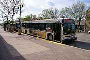
Mass transit in Lethbridge consists of 40 buses (with an average age of 10 years) covering most of the city on 16 routes and managed by Lethbridge Transit
. Traditionally, all bus routes in the city started and ended downtown. In the early 21st century, however, cross-town and shuttle routes have been introduced. For example, there is now service from the University of Lethbridge
to Lethbridge College, University of Lethbridge to the North Lethbridge terminal, and from Lethbridge College to the North Lethbridge terminal. Two of those routes still make brief stops downtown.
The transit system does not use zone fares and the cost of fare is the same regardless of the number of transfers made. Buses meet at four transit terminals: downtown, University of Lethbridge, Lethbridge Community College, and the North Lethbridge terminal. Although not officially a terminal, several routes also converge near the Chinook Regional Hospital
.
In addition to the transit system, Lethbridge has several taxicab
and limousine
companies offering service throughout the city and to destinations outside city limits (including the Lethbridge County Airport). Lethbridge also has a Greyhound
depot, providing bus service to British Columbia
, Saskatchewan
, Calgary and Montana
.
with other areas of the city, including Pavan Park in the north, Henderson Park
in the east, Highways 4 and 5 in the south and a loop in West Lethbridge
(including University Drive and McMaster Blvd).
rail yards in Kipp. The rail yards were moved to Kipp, just west of the city, from downtown Lethbridge
in 1983 to make way for commercial expansion.
The city is located on a mainline of the Canadian Pacific Railway with trackage east to Toronto
, south to the United States
, west to Vancouver
, and north to Calgary. Despite the marshalling yard being located in Kipp, there are still full freight-handling facilities located in the city. In addition, spur trackage serves the industrial areas, and a rail loading facility is available to all businesses.
Rail service in Lethbridge includes the well-known Lethbridge Viaduct
, known locally as the High Level Bridge. It is one of the highest and longest steel railway truss bridges in the world.
Passenger rail service stopping in Lethbridge was discontinued in 1971 by CPR.
provides commercial flights to Calgary
and Edmonton
, as well as private and charter flights to various other destinations. The airport provides customs services for any flights coming in from the United States. The airport is located on Highway 5 two kilometres south of the city.
Lethbridge is 220 km from Calgary International Airport
and 300 km from Great Falls International Airport
, both of which provide commercial service to other destinations.
, 4, 5, and 25) run through or terminate in Lethbridge. This has led to the creation of major arterial roads (including Mayor Magrath Drive
, University Drive and Scenic Drive) and a freeway (Crowsnest Trail). This, and the fact Lethbridge is located on the CANAMEX Corridor
, has led to Lethbridge being a major shipping destination, with over a dozen trucking firms having depots located in the city.
Lethbridge is 100 kilometres (62 mi.) north of the United States
border via Highways 4 and 5; and 210 km (130 mi.) south of Calgary via Highways 2 and 3. Highways 2, 3 and 4 form part of the CANAMEX trade route between Mexico, the United States, and Canada.
Highway 5 leads out to the Lethbridge County Airport, satellite communities (such as Magrath
and Welling
), Waterton Lakes National Park
and the Canada-United States border via Highway 2. In the city limits, it intersects with Highway 4 and becomes Mayor Magrath Drive, which later intersects with the Crowsnest Highway.
Highway 4 leads out to satellite communities (such as Stirling
and Warner
) and the Canada-United States border, where it meets Interstate 15
, connecting eventually to Salt Lake City
, Las Vegas
and San Diego
. In the city limits, it intersects with Highway 5 and becomes Scenic Drive, which later intersects with Whoop-up Drive (the busiest road in Lethbridge) and Crowsnest Trail.
Highway 3 — also known as the Crowsnest Trail — provides east-west service to British Columbia
and Medicine Hat
, where it meets up with the Trans-Canada Highway
. Fort Macleod
is only 51 km (32 mi) west of Lethbridge and provides service to Calgary via Highway 2. Several satellite communities (such as Coalhurst and Coaldale
) are located on Highway 3. Of all the highways servicing Lethbridge, only Highway 3 does not terminate in the city.
Highway 25 provides service to satellite communities (such as Picture Butte
and Diamond City
). In the city, the highway turns into University Drive and services a major retail centre and the University of Lethbridge
. It intersects with Whoop-up Drive and the Crowsnest Highway.
 The following are arterial and collector roads in Lethbridge. The numbers listed are the total number of maximum vehicle traffic during weekdays for 2010. Only roads reaching at least 6,000 vehicles per day, which is the cut off for a "major collector" classification, are listed below.
, the second busiest roadway in Lethbridge, was upgraded to six lanes from 3 Avenue South to 34 Avenue South.
In 2006, Whoop-up Drive, the busiest roadway in the city, was extended to 24 Avenue West. This extension provided direct service for the residential community of Sunset Acres and service for The Crossings, the planned commercial core of West Lethbridge
, and the residential neighbourhood of Copperwood. In addition, University Drive was widened from Whoop-up Drive to the location of the proposed sports arena, making the roadway six lanes in areas, including multiple turning lanes onto access roads for the University of Lethbridge.
Future projects include extending Scenic Drive to Stafford Drive North by 2012. Discussions have taken place regarding the creation of Metis Trail in West Lethbridge (paralleling University Drive) and Chinook Trail, a ring-road intersecting with Crowsnest Trail on the Westside and connecting with 43 Street South in the east. Chinook Trail would include a third crossing of the Oldman River.
Commuting
In 2003, Lethbridge College conducted a public opinion survey regarding commuting choice in LethbridgeLethbridge
Lethbridge is a city in the province of Alberta, Canada, and the largest city in southern Alberta. It is Alberta's fourth-largest city by population after Calgary, Edmonton and Red Deer, and the third-largest by area after Calgary and Edmonton. The nearby Canadian Rockies contribute to the city's...
. This survey found that less than 20% of Lethbridge residents regularly used the public transit system.
In 2006, the Lethbridge Public Library released a study that stated in part up to 130,000 people commute to Lethbridge from a radius of 100 km. Since the local public transit system does not extend outside city boundaries, presumably these commuters use automobiles.
Public transit
Mass transit in Lethbridge consists of 40 buses (with an average age of 10 years) covering most of the city on 16 routes and managed by Lethbridge Transit
Lethbridge Transit
Lethbridge Transit manages and operates the municipally-owned public transportation system in Lethbridge, Alberta, Canada.-History:...
. Traditionally, all bus routes in the city started and ended downtown. In the early 21st century, however, cross-town and shuttle routes have been introduced. For example, there is now service from the University of Lethbridge
University of Lethbridge
The University of Lethbridge is a publicly-funded comprehensive academic and research university, founded in the liberal education tradition, located in Lethbridge, Alberta, Canada, with two other urban campuses in Calgary and Edmonton. The main building sits among the coulees on the west side of...
to Lethbridge College, University of Lethbridge to the North Lethbridge terminal, and from Lethbridge College to the North Lethbridge terminal. Two of those routes still make brief stops downtown.
The transit system does not use zone fares and the cost of fare is the same regardless of the number of transfers made. Buses meet at four transit terminals: downtown, University of Lethbridge, Lethbridge Community College, and the North Lethbridge terminal. Although not officially a terminal, several routes also converge near the Chinook Regional Hospital
Chinook Regional Hospital
Chinook Regional Hospital is the main hospital in southern Alberta and offers many of the health care services for Alberta Health Services. The hospital services a population of over 150,000 and is supported by the Chinook Regional Hospital Foundation....
.
In addition to the transit system, Lethbridge has several taxicab
Taxicab
A taxicab, also taxi or cab, is a type of vehicle for hire with a driver, used by a single passenger or small group of passengers, often for a non-shared ride. A taxicab conveys passengers between locations of their choice...
and limousine
Limousine
A limousine is a luxury sedan or saloon car, especially one with a lengthened wheelbase or driven by a chauffeur. The chassis of a limousine may have been extended by the manufacturer or by an independent coachbuilder. These are called "stretch" limousines and are traditionally black or white....
companies offering service throughout the city and to destinations outside city limits (including the Lethbridge County Airport). Lethbridge also has a Greyhound
Greyhound Lines of Canada
Greyhound Canada is the prominent operator of inter-city coach services in Canada. Greyhound Canada is a subsidiary of Scotland's FirstGroup plc, linked with Dallas-based Greyhound Lines .-History:In 1929, Greyhound Canada was founded as Canadian Greyhound Coaches, Limited, operating in Alberta...
depot, providing bus service to British Columbia
British Columbia
British Columbia is the westernmost of Canada's provinces and is known for its natural beauty, as reflected in its Latin motto, Splendor sine occasu . Its name was chosen by Queen Victoria in 1858...
, Saskatchewan
Saskatchewan
Saskatchewan is a prairie province in Canada, which has an area of . Saskatchewan is bordered on the west by Alberta, on the north by the Northwest Territories, on the east by Manitoba, and on the south by the U.S. states of Montana and North Dakota....
, Calgary and Montana
Montana
Montana is a state in the Western United States. The western third of Montana contains numerous mountain ranges. Smaller, "island ranges" are found in the central third of the state, for a total of 77 named ranges of the Rocky Mountains. This geographical fact is reflected in the state's name,...
.
Coal Banks Trail system
The Parks and Recreation department maintains the city-wide, 30-kilometre, pedestrian/cyclist Coal Banks Trail system (map). The system was designed to connect the Oldman River valleyOldman River valley parks system
The Oldman River valley parks system is a continuous collection of eight urban parks in the Oldman River valley of Lethbridge, Alberta, 100 metres below the prairie level. The parks were created in the 1980s as part of the city's Urban Parks Project...
with other areas of the city, including Pavan Park in the north, Henderson Park
Henderson Park (Lethbridge)
Henderson Park is a 47 hectare located in Lethbridge, Alberta, Canada. The park contains many amenities and attractions, including a 24 hectare man-made lake, the largest lake in the city...
in the east, Highways 4 and 5 in the south and a loop in West Lethbridge
West Lethbridge
West Lethbridge , is one of three geographical areas in Lethbridge, Alberta, Canada. It is the newest and the fastest growing...
(including University Drive and McMaster Blvd).
Rail service
In addition to having significant road service, Lethbridge is very close to the CPRCanadian Pacific Railway
The Canadian Pacific Railway , formerly also known as CP Rail between 1968 and 1996, is a historic Canadian Class I railway founded in 1881 and now operated by Canadian Pacific Railway Limited, which began operations as legal owner in a corporate restructuring in 2001...
rail yards in Kipp. The rail yards were moved to Kipp, just west of the city, from downtown Lethbridge
Downtown Lethbridge
Downtown Lethbridge is the commercial centre of Lethbridge, Alberta, hosting most of the city's banks and several accounting and law practices, including national firms.-Boundaries:...
in 1983 to make way for commercial expansion.
The city is located on a mainline of the Canadian Pacific Railway with trackage east to Toronto
Toronto
Toronto is the provincial capital of Ontario and the largest city in Canada. It is located in Southern Ontario on the northwestern shore of Lake Ontario. A relatively modern city, Toronto's history dates back to the late-18th century, when its land was first purchased by the British monarchy from...
, south to the United States
United States
The United States of America is a federal constitutional republic comprising fifty states and a federal district...
, west to Vancouver
Vancouver
Vancouver is a coastal seaport city on the mainland of British Columbia, Canada. It is the hub of Greater Vancouver, which, with over 2.3 million residents, is the third most populous metropolitan area in the country,...
, and north to Calgary. Despite the marshalling yard being located in Kipp, there are still full freight-handling facilities located in the city. In addition, spur trackage serves the industrial areas, and a rail loading facility is available to all businesses.
Rail service in Lethbridge includes the well-known Lethbridge Viaduct
Lethbridge Viaduct
The Lethbridge Viaduct, commonly known as the High Level Bridge, was constructed between 1907–1909 at Lethbridge, Alberta, Canada at a cost of $1,334,525.- Overview :...
, known locally as the High Level Bridge. It is one of the highest and longest steel railway truss bridges in the world.
Passenger rail service stopping in Lethbridge was discontinued in 1971 by CPR.
Airport
The Lethbridge County AirportLethbridge County Airport
Lethbridge County Airport or Lethbridge Airport, , is located south southeast of Lethbridge, Alberta, Canada. It is 10-15 driving minutes from the downtown area and has scheduled service to the Alberta cities of Calgary and Edmonton. The airport is classified as an airport of entry by NAV CANADA...
provides commercial flights to Calgary
Calgary
Calgary is a city in the Province of Alberta, Canada. It is located in the south of the province, in an area of foothills and prairie, approximately east of the front ranges of the Canadian Rockies...
and Edmonton
Edmonton
Edmonton is the capital of the Canadian province of Alberta and is the province's second-largest city. Edmonton is located on the North Saskatchewan River and is the centre of the Edmonton Capital Region, which is surrounded by the central region of the province.The city and its census...
, as well as private and charter flights to various other destinations. The airport provides customs services for any flights coming in from the United States. The airport is located on Highway 5 two kilometres south of the city.
Lethbridge is 220 km from Calgary International Airport
Calgary International Airport
Calgary International Airport, , is the international airport that serves Calgary, Alberta, Canada and the surrounding region; it is situated approximately northeast of downtown Calgary...
and 300 km from Great Falls International Airport
Great Falls International Airport
Great Falls International Airport is a joint civil-military public airport located within city limits, three miles southwest of central Great Falls in Cascade County, Montana, USA...
, both of which provide commercial service to other destinations.
Highways
Four provincial highways (3Crowsnest Highway
The Crowsnest Highway, also known as the Interprovincial or, in British Columbia, the Southern Trans-Provincial, is an east-west highway, in length, through the southern parts of British Columbia and Alberta, providing the shortest highway connection between British Columbia's Lower Mainland and...
, 4, 5, and 25) run through or terminate in Lethbridge. This has led to the creation of major arterial roads (including Mayor Magrath Drive
Mayor Magrath Drive
Mayor Magrath Drive is the busiest north-south roadway and the second busiest roadway overall in Lethbridge, Alberta. In 2005, it saw roughly 34,000 vehicles per day in weekday traffic...
, University Drive and Scenic Drive) and a freeway (Crowsnest Trail). This, and the fact Lethbridge is located on the CANAMEX Corridor
CANAMEX Corridor
The CANAMEX corridor is a corridor linking Canada to Mexico through the United States. The corridor was established under the North American Free Trade Agreement.Currently the corridor is defined by a series of highways...
, has led to Lethbridge being a major shipping destination, with over a dozen trucking firms having depots located in the city.
Lethbridge is 100 kilometres (62 mi.) north of the United States
United States
The United States of America is a federal constitutional republic comprising fifty states and a federal district...
border via Highways 4 and 5; and 210 km (130 mi.) south of Calgary via Highways 2 and 3. Highways 2, 3 and 4 form part of the CANAMEX trade route between Mexico, the United States, and Canada.
Highway 5 leads out to the Lethbridge County Airport, satellite communities (such as Magrath
Magrath, Alberta
Magrath is a town in Cardston County, Alberta, Canada. Its 2006 population was 2,081. Magrath is located near the Canadian Rockies and is south of Lethbridge and south of Calgary.- History :...
and Welling
Welling, Alberta
Welling is a hamlet in southern Alberta, Canada within Cardston County. It is located north of the junction of Highway 5 and Highway 52, approximately south of the City of Lethbridge.- History :...
), Waterton Lakes National Park
Waterton Lakes National Park
Waterton Lakes National Park is a national park located in the southwest corner of Alberta, Canada, and borders Glacier National Park in Montana, USA. Waterton was Canada's fourth national park, formed in 1895 and named after Waterton Lake, in turn after the Victorian naturalist and conservationist...
and the Canada-United States border via Highway 2. In the city limits, it intersects with Highway 4 and becomes Mayor Magrath Drive, which later intersects with the Crowsnest Highway.
Highway 4 leads out to satellite communities (such as Stirling
Stirling, Alberta
Stirling is a village in the County of Warner No. 5, Alberta, Canada. The village is located on Highway 4, approximately southeast of Lethbridge and northwest of the United States-Canada border....
and Warner
Warner, Alberta
Warner is a village in southern Alberta, Canada. It is located in County of Warner, approximately 65 km south of the city of Lethbridge. Warner is a farming community. Warner is situated at the intersection of Highway 4 and Highway 36, about 38 km north of the Montana border and...
) and the Canada-United States border, where it meets Interstate 15
Interstate 15
Interstate 15 is the fourth-longest north–south Interstate Highway in the United States, traveling through the states of California, Nevada, Arizona, Utah, Idaho, and Montana from San Diego to the Canadian border...
, connecting eventually to Salt Lake City
Salt Lake City, Utah
Salt Lake City is the capital and the most populous city of the U.S. state of Utah. The name of the city is often shortened to Salt Lake or SLC. With a population of 186,440 as of the 2010 Census, the city lies in the Salt Lake City metropolitan area, which has a total population of 1,124,197...
, Las Vegas
Las Vegas, Nevada
Las Vegas is the most populous city in the U.S. state of Nevada and is also the county seat of Clark County, Nevada. Las Vegas is an internationally renowned major resort city for gambling, shopping, and fine dining. The city bills itself as The Entertainment Capital of the World, and is famous...
and San Diego
San Diego, California
San Diego is the eighth-largest city in the United States and second-largest city in California. The city is located on the coast of the Pacific Ocean in Southern California, immediately adjacent to the Mexican border. The birthplace of California, San Diego is known for its mild year-round...
. In the city limits, it intersects with Highway 5 and becomes Scenic Drive, which later intersects with Whoop-up Drive (the busiest road in Lethbridge) and Crowsnest Trail.
Highway 3 — also known as the Crowsnest Trail — provides east-west service to British Columbia
British Columbia
British Columbia is the westernmost of Canada's provinces and is known for its natural beauty, as reflected in its Latin motto, Splendor sine occasu . Its name was chosen by Queen Victoria in 1858...
and Medicine Hat
Medicine Hat, Alberta
Medicine Hat, known to locals as "The Hat", is a city of 61,097 people located in the southeastern part of the province of Alberta, Canada. It is enclaved within Cypress County along with the nearby Town of Redcliff, although neither is part of the county....
, where it meets up with the Trans-Canada Highway
Trans-Canada Highway
The Trans-Canada Highway is a federal-provincial highway system that joins the ten provinces of Canada. It is, along with the Trans-Siberian Highway and Australia's Highway 1, one of the world's longest national highways, with the main route spanning 8,030 km...
. Fort Macleod
Fort Macleod, Alberta
Fort Macleod is a town in the southwest corner of the province of Alberta, Canada. It was founded as a North-West Mounted Police barracks, and is named in honour of the North-West Mounted Police Colonel James Macleod. The town's current mayor is Shawn Patience.- History and heritage preservation...
is only 51 km (32 mi) west of Lethbridge and provides service to Calgary via Highway 2. Several satellite communities (such as Coalhurst and Coaldale
Coaldale, Alberta
Coaldale is a town in southern Alberta, Canada, located east of Lethbridge, along the Crowsnest Highway.- Attractions :The main attractions are the Alberta Birds of Prey Centre, the Land o' Lakes Golf Course, and the Gem of the West Museum....
) are located on Highway 3. Of all the highways servicing Lethbridge, only Highway 3 does not terminate in the city.
Highway 25 provides service to satellite communities (such as Picture Butte
Picture Butte, Alberta
Picture Butte is a town in southern Alberta, Canada. It is located north of the city of Lethbridge. It claims the title of "Livestock Feeding Capital of Canada."...
and Diamond City
Diamond City, Alberta
Diamond City is a hamlet in southern Alberta, Canada within the County of Lethbridge. It is located on Highway 25, approximately north of Lethbridge.Diamond City was first settled at the turn of the 20th century by farmers, ranchers and miners....
). In the city, the highway turns into University Drive and services a major retail centre and the University of Lethbridge
University of Lethbridge
The University of Lethbridge is a publicly-funded comprehensive academic and research university, founded in the liberal education tradition, located in Lethbridge, Alberta, Canada, with two other urban campuses in Calgary and Edmonton. The main building sits among the coulees on the west side of...
. It intersects with Whoop-up Drive and the Crowsnest Highway.
Major roads
| Road | Type | Weekday traffic | Lanes |
|---|---|---|---|
| Whoop-up Drive | Arterial | 44,200 | 6 |
| Mayor Magrath Drive Mayor Magrath Drive Mayor Magrath Drive is the busiest north-south roadway and the second busiest roadway overall in Lethbridge, Alberta. In 2005, it saw roughly 34,000 vehicles per day in weekday traffic... South |
Arterial | 34,000 | 6 |
| Crowsnest Trail | Arterial | 30,300 | 4 |
| Stafford Drive | Arterial | 21,800 | 4 |
| Scenic Drive | Arterial | 21,700 | 2–4 |
| University Drive West | Arterial | 25,400 | 4–6 |
| 13 Street | Arterial | 19,600 | 2–4 |
| 6 Avenue South | Arterial | 18,600 | 4 |
| 3 Avenue South | Arterial | 18,400 | 4 |
| 43 Street | Super collector | 16,000 | 2–4 |
| 2/2A Avenue North | Super collector | 14,300 | 2 |
| 5 Avenue North | Super collector | 14,000 | 2 |
| McMaster Boulevard/Jerry Potts Boulevard | Super collector | 13,200 | 2 |
| 1 Avenue South | Super collector | 11,700 | 4 |
| 10 Avenue South/South Parkside Drive South | Super collector | 10,700 | 2 |
| 20 Avenue South | Super Collector | 9,700 | 2–4 |
| 23 Street North | Super Collector | 9,500 | 2–4 |
| 9 Avenue North | Major collector | 8,600 | 2 |
| 4 Avenue South | Super collector | 8,400 | 4 |
| 16 Avenue South | Super collector | 8,400 | 2 |
| 2/2A Avenue North | Super collector | 14,300 | 2 |
| 26 Avenue North | Major collector | 7,300 | 2 |
| 5 Avenue S | Major collector | 6,500 | 4 |
| Stafford Avenue/St. Edwards Boulevard/18 Avenue North/Park Boulevard | Major collector | 6,500 | 2 |
Major infrastructure projects
Since 2000, several major infrastructure projects have been implemented in the city to accommodate current and planned traffic use. From 2001–2005, Mayor Magrath DriveMayor Magrath Drive
Mayor Magrath Drive is the busiest north-south roadway and the second busiest roadway overall in Lethbridge, Alberta. In 2005, it saw roughly 34,000 vehicles per day in weekday traffic...
, the second busiest roadway in Lethbridge, was upgraded to six lanes from 3 Avenue South to 34 Avenue South.
In 2006, Whoop-up Drive, the busiest roadway in the city, was extended to 24 Avenue West. This extension provided direct service for the residential community of Sunset Acres and service for The Crossings, the planned commercial core of West Lethbridge
West Lethbridge
West Lethbridge , is one of three geographical areas in Lethbridge, Alberta, Canada. It is the newest and the fastest growing...
, and the residential neighbourhood of Copperwood. In addition, University Drive was widened from Whoop-up Drive to the location of the proposed sports arena, making the roadway six lanes in areas, including multiple turning lanes onto access roads for the University of Lethbridge.
Future projects include extending Scenic Drive to Stafford Drive North by 2012. Discussions have taken place regarding the creation of Metis Trail in West Lethbridge (paralleling University Drive) and Chinook Trail, a ring-road intersecting with Crowsnest Trail on the Westside and connecting with 43 Street South in the east. Chinook Trail would include a third crossing of the Oldman River.