

Transportation in Georgia (U.S. state)
Encyclopedia
Transportation in Georgia
utilizes a combination of road, rail, air, and water modes.
 In March 2011, Georgia ranked as a bottom-seven "Worst" state (tied with Illinois
and Oklahoma
) in the American State Litter Scorecard. The Peach State suffers from overall poor effectiveness and quality of its statewide public space cleanliness (primarily from roadway and adjacent litter/debris abatement)--due to state and related eradication standards and performance indicators.
The state of Georgia has 1,244 miles of interstate highway within its borders. Georgia's major Interstate Highway
s are I-95
, I-75
, I-16
, I-85
, I-20
. Other important interstate highways are I-24
and I-59
. I-285
is Atlanta, Georgia
's perimeter route and I-575
connects with counties in north Georgia on I-75. The Georgia Department of Transportation
maintains only 16 percent of the roads in the state. The other 84 percent are the responsibility of the counties and cities; 75 percent of those roads are county roads.
routes: the Crescent
, which runs from New York to Washington, D.C., through north Georgia and Atlanta to New Orleans and the other runs from New York to the Georgia coast and from there to Florida.
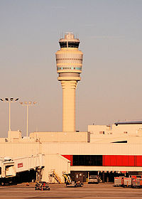 Georgia's principal airport is Hartsfield-Jackson Atlanta International Airport
(ATL), the world's busiest passenger airport. Georgia has one hundred seven public-use airports, nine of which are commercial-aviation airports and ninety-eight which are general-aviation airports. Two of the state's important airports are Savannah/Hilton Head International Airport
, which serves over 1,700,000 passengers each year and DeKalb Peachtree Airport in Chamblee, Georgia
.
Georgia (U.S. state)
Georgia is a state located in the southeastern United States. It was established in 1732, the last of the original Thirteen Colonies. The state is named after King George II of Great Britain. Georgia was the fourth state to ratify the United States Constitution, on January 2, 1788...
utilizes a combination of road, rail, air, and water modes.
Highway system
Illinois
Illinois is the fifth-most populous state of the United States of America, and is often noted for being a microcosm of the entire country. With Chicago in the northeast, small industrial cities and great agricultural productivity in central and northern Illinois, and natural resources like coal,...
and Oklahoma
Oklahoma
Oklahoma is a state located in the South Central region of the United States of America. With an estimated 3,751,351 residents as of the 2010 census and a land area of 68,667 square miles , Oklahoma is the 28th most populous and 20th-largest state...
) in the American State Litter Scorecard. The Peach State suffers from overall poor effectiveness and quality of its statewide public space cleanliness (primarily from roadway and adjacent litter/debris abatement)--due to state and related eradication standards and performance indicators.
The state of Georgia has 1,244 miles of interstate highway within its borders. Georgia's major Interstate Highway
Interstate Highway System
The Dwight D. Eisenhower National System of Interstate and Defense Highways, , is a network of limited-access roads including freeways, highways, and expressways forming part of the National Highway System of the United States of America...
s are I-95
Interstate 95
Interstate 95 is the main highway on the East Coast of the United States, running parallel to the Atlantic Ocean from Maine to Florida and serving some of the most populated urban areas in the country, including Boston, Providence, New Haven, New York City, Newark, Philadelphia, Baltimore,...
, I-75
Interstate 75
Interstate 75 is a major north–south Interstate Highway in the Great Lakes and Southeastern regions of the United States. It travels from State Road 826 and State Road 924 in Hialeah, Florida to Sault Ste. Marie, Michigan, at the Ontario, Canada, border...
, I-16
Interstate 16
Interstate 16 , also known as Jim Gillis Historic Savannah Parkway or State Route 404 , is an intrastate Interstate Highway located entirely within the state of Georgia, United States...
, I-85
Interstate 85
Interstate 85 is a major interstate highway in the Southeastern United States. Its current southern terminus is at an interchange with Interstate 65 in Montgomery, Alabama; its northern terminus interchanges with Interstate 95 in Petersburg, Virginia, near Richmond...
, I-20
Interstate 20
Interstate 20 is a major east–west Interstate Highway in the Southern United States. I‑20 runs 1,535 miles from near Kent, Texas, at Interstate 10 to Florence, South Carolina, at Interstate 95...
. Other important interstate highways are I-24
Interstate 24
Interstate 24 is an Interstate Highway in the Midwestern and Southeastern United States. It runs diagonally from Interstate 57 to Chattanooga, Tennessee, at Interstate 75....
and I-59
Interstate 59
Interstate 59 is an Interstate Highway in the southern United States. Its southern terminus is near Slidell, Louisiana, a suburb of New Orleans, at an intersection with Interstate 10 and Interstate 12, its northern terminus is at Wildwood, Georgia, at an intersection with Interstate 24.The road's...
. I-285
Interstate 285
Interstate 285 is an Interstate Highway loop encircling Atlanta, Georgia, for . I-285 is also known as unsigned State Route 407 and is colloquially referred to as the Perimeter. Suburban sprawl has made it one of the most heavily traveled roadways in the United States, and portions of the highway...
is Atlanta, Georgia
Atlanta, Georgia
Atlanta is the capital and most populous city in the U.S. state of Georgia. According to the 2010 census, Atlanta's population is 420,003. Atlanta is the cultural and economic center of the Atlanta metropolitan area, which is home to 5,268,860 people and is the ninth largest metropolitan area in...
's perimeter route and I-575
Interstate 575
Interstate 575 is an Interstate Highway spur route in the United States, which branches off Interstate 75 in Kennesaw and connects the metro Atlanta area with the north Georgia mountains. I-575 is also the unsigned State Route 417 and is cosigned as SR 5...
connects with counties in north Georgia on I-75. The Georgia Department of Transportation
Georgia Department of Transportation
The Georgia Department of Transportation is the organization in charge of developing and maintaining all state and federal roadways in the U.S. state of Georgia. In addition to highways, the department also has a limited role in developing public transportation and general aviation programs...
maintains only 16 percent of the roads in the state. The other 84 percent are the responsibility of the counties and cities; 75 percent of those roads are county roads.
Bike routes
Georgia has a system of State Bicycle Routes.Railroads
Major freight railroads in Georgia include CSX and Norfolk Southern. Passenger service in Georgia is available on two AmtrakAmtrak
The National Railroad Passenger Corporation, doing business as Amtrak , is a government-owned corporation that was organized on May 1, 1971, to provide intercity passenger train service in the United States. "Amtrak" is a portmanteau of the words "America" and "track". It is headquartered at Union...
routes: the Crescent
Crescent (Amtrak)
The Crescent is a passenger train operated by Amtrak in the eastern part of the United States. It runs daily from Pennsylvania Station in New York City to New Orleans Union Passenger Terminal in New Orleans, Louisiana as train 19 and returns, on the same route, as train 20. Most of the route of...
, which runs from New York to Washington, D.C., through north Georgia and Atlanta to New Orleans and the other runs from New York to the Georgia coast and from there to Florida.
Air transportation
Hartsfield-Jackson Atlanta International Airport
Hartsfield–Jackson Atlanta International Airport , known locally as Atlanta Airport, Hartsfield Airport, and Hartsfield–Jackson, is located seven miles south of the central business district of Atlanta, Georgia, United States...
(ATL), the world's busiest passenger airport. Georgia has one hundred seven public-use airports, nine of which are commercial-aviation airports and ninety-eight which are general-aviation airports. Two of the state's important airports are Savannah/Hilton Head International Airport
Savannah/Hilton Head International Airport
"Savannah/Hilton Head International Airport , formerly Savannah International Airport, Travis Field and Chatham Field, is a joint civil-military airport located northwest of Savannah, Georgia just off Interstate 95, between Savannah and the city of Pooler, Georgia...
, which serves over 1,700,000 passengers each year and DeKalb Peachtree Airport in Chamblee, Georgia
Chamblee, Georgia
As of the 2010 Census Chamblee had a population of 9,892. The racial and ethnic composition of the population was 45.0% white , 7.0% black or African American , 2.1% Native American , 1.8% Vietnamese, 1.6% Asian Indian, 4.6% other Asian, 33.5% from some other race and...
.