

Transport in Niger
Encyclopedia
History of Niger
This is the history of Niger. See also the history of Africa and the history of West Africa.-Pre-historic Niger:Humans have lived in what is now Niger from the earliest times...
(1899–1960), relying upon animal transport, human transport, and limited river transport in the far south west and south east. No railways were constructed in the colonial period, and roads outside the capital remained unpaved. The Niger River is unsuitable for river transport of any large scale, as it lacks depth for most of the year, and is broken by rapids at many spots. Camel caravan
Camel train
A camel train is a series of camels carrying goods or passengers in a group as part of a regular or semi-regular service between two points. Although they rarely travelled faster than the walking speed of a man, camels' ability to handle harsh conditions made camel trains a vital part of...
transport was historically important in the Sahara desert and Sahel
Sahel
The Sahel is the ecoclimatic and biogeographic zone of transition between the Sahara desert in the North and the Sudanian Savannas in the south.It stretches across the North African continent between the Atlantic Ocean and the Red Sea....
regions which cover most of the north.
Governance
Transport, including motor vehicles, highways, airports, and port authorities, are overseen by the Nigerien Ministry of Transport's Directorate for Land Water and Air Transport ("Ministère des Transport et de l'aviation civile/Direction des Transports Terrestres, Maritimes et Fluviaux"). Border controls and import/export duties are overseen by an independent tax police, the "Police du Douanes. Air traffic control is overseen and operated in conjunction with the pan-African ASECNAASECNA
The Agency for Aerial Navigation Safety in Africa and Madagascar is an air traffic control agency based in Dakar, Senegal...
, which bases one of its five air traffic zones at Niamey
Niamey
-Population:While Niamey's population has grown steadily since independence, the droughts of the early 1970s and 1980s, along with the economic crisis of the early 1980s, have propelled an exodus of rural inhabitants to Niger's largest city...
's Hamani Diori International Airport. A non-governmental body, the Nigerien Council of Users of Public Transport ("Conseil Nigérien des Utilisateurs des Transports Publics CNUT") advocates on behalf of users of public transport, including roads and airports.
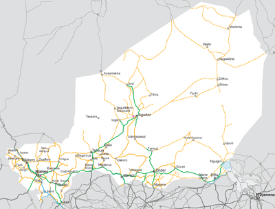
Highways

Arlit
Arlit is an industrial town and capital of the Arlit Department of the Agadez Region of northern-central Niger, built between the Sahara desert and the eastern edge of the Aïr mountains. It is 200 km south by road from the border with Algeria...
to the Benin
Benin
Benin , officially the Republic of Benin, is a country in West Africa. It borders Togo to the west, Nigeria to the east and Burkina Faso and Niger to the north. Its small southern coastline on the Bight of Benin is where a majority of the population is located...
border in the 1970s and 1980s. This road, dubbed the Uranium Highway runs through Arlit
Arlit
Arlit is an industrial town and capital of the Arlit Department of the Agadez Region of northern-central Niger, built between the Sahara desert and the eastern edge of the Aïr mountains. It is 200 km south by road from the border with Algeria...
, Agadez
Agadez
-Sources:* Aboubacar Adamou. "Agadez et sa région. Contribution à l'étude du Sahel et du Sahara nigériens", Études nigériennes, n°44, , 358 p.* Julien Brachet. Migrations transsahariennes. Vers un désert cosmopolite et morcelé . Paris: Le Croquant, , 324 p. ISBN : 978-2-91496865-2.*. Saudi Aaramco...
, Tahoua
Tahoua
Tahoua is a city in Niger and the administrative center of the Department of Tahoua and the larger Tahoua Region. It has a population of 99,900 . The city is primarily a market town for the surrounding agricultural area, and a meeting place for the Tuareg people from the north and the Fulani people...
, Birnin-Konni, and Niamey
Niamey
-Population:While Niamey's population has grown steadily since independence, the droughts of the early 1970s and 1980s, along with the economic crisis of the early 1980s, have propelled an exodus of rural inhabitants to Niger's largest city...
, and is part of the Trans-Sahara Highway
Trans-Sahara Highway
The Trans-Sahara Highway is a transnational highway project to pave, improve and ease border formalities on an existing trade route across the Sahara Desert...
system.
An additional paved highway runs from Niamey via Maradi and Zinder
Zinder
Zinder is the second largest city in Niger, with a population of 170,574 by 2005 was estimated to be over 200,000...
towards Diffa
Diffa
Diffa is a city and Urban Commune in the extreme southeast of Niger, near that country's border with Nigeria, with a population of 23,600 . It is the administrative seat of both Diffa Region, and the smaller Diffa Department...
in the far east of the nation, although the stretch from Zinder to Diffa is only partially paved. Portions of this route are used by the Trans-Sahel Highway route. The Niger section runs 837 km (of which 600 km was in poor condition as of 2000), via Niamey, Dosso
Dosso, Niger
Dosso is a town in the south-west corner of Niger. It lies 130–140 km south-east of the capital Niamey at the junction of the main routes to Zinder and Benin. The seventh most populous town in Niger and the largest in Dosso Region, it had an official population during the 2001 census of 43,561...
, Dogondoutchi
Dogondoutchi
Dogondoutchi is a city located in the east of the Dosso Region of Niger. With a population of 29,244 , Dogondoutchi is the largest city in and administrative center of the Dogondoutchi department, the easternmost section of Dosso Region....
, Birnin-Konni and Maradi to the Nigerian border at Jibiya.
Other roads range from all-weather laterite surfaces to grated dirt or sand Piste
Piste
A piste is a marked ski run or path down a mountain for snow skiing, snowboarding, or other mountain sports. The term is European, from the French for trail or track, synonymous with trail, slope, or groomed run in North America....
s, especially in the desert north.
The United States government in 1996 estimated there were a total of 10100 km of highways in Niger, with 798 km paved and 9302 km, unpaved, but making no distinction between improved or all weather roads and unimproved roads. The government of Niger, in 2009, gave a figure of 18949 km of total roadways.
Routes Nationale
The national road system ("Routes Nationale") are numbered and prefixed with "RN", as RN1. The numbering system contains routes or sections which are as yet unpaved or even unimproved tracks. Route Nationale no. 25, for example, is a major paved highway from Niamey to FilinguéFilingue
Filingue is a town in southwestern Niger and is the capital city of Filingue Department. It is near to Niger's capital city Niamey....
, follows the partially improved Route Nationale no. 26 towards Abala
Abala, Niger
-References:...
, veers off onto a dirt track (locally called a Piste) from the villages of Talcho to Sanam, where RN26 also terminates from another direction. RN25 then continues along a piste, through largely uninhabited desert for almost 100 km before reaching the city of Tahoua
Tahoua
Tahoua is a city in Niger and the administrative center of the Department of Tahoua and the larger Tahoua Region. It has a population of 99,900 . The city is primarily a market town for the surrounding agricultural area, and a meeting place for the Tuareg people from the north and the Fulani people...
, served by other major paved roads. The main "Uranium Highway" then coincides with the RN25 all the way to Arlit
Arlit
Arlit is an industrial town and capital of the Arlit Department of the Agadez Region of northern-central Niger, built between the Sahara desert and the eastern edge of the Aïr mountains. It is 200 km south by road from the border with Algeria...
in the far north. Consequently, the informal names for the routes (e.g. "Uranium Highway") serves a somewhat more practical purpose that the RN numbers.
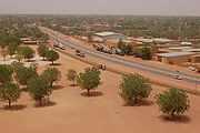
Road transport
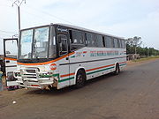
Nigeriens in both urban and rural areas rely on a combination of motor vehicles and animals for transport of themselves and commercial goods. Road transport is the major form of travel across the huge distances between Nigerien population centers, though most Nigeriens do not own vehicles. In cities, public transport systems within cities are largely absent, so a variety of privately operated services carry many urban dwellers. Vans, cars, motor coaches, trucks, and even converted motorbikes provide paid transport. Between cities coach systems are the standard form of personal transport, with the government operating one bus service (the SNTVSociéte Nigerienne de Transports de Voyageurs
The Sociéte Nigerienne de Transports de Voyageurs or SNTV is the Nigerien government owned bus and public transport company.-Operation:...
), and a multitude of buses, "bush taxis" (taxi brousse), small vans and semi-converted trucks taking passengers and goods. Services are sometimes scheduled from the "Highway stations" ("Gares routières") found in every town, but are more frequently ad hoc: vehicles ply the trade between towns, picking up at stations or anywhere along the route, and departing only when full.
Animals pulling wagons and loaded camel trains remain a common sight on Nigerien roads.
Motor vehicle regulation
Vehicles in Niger are subject to the "Laws of the Road" ("Code de la route") for which the government began a continuing reform in 2004-2006 and is based substantially on French models. Vehicles travel on the right side of the road, and roads use French style signage. Routes Nationale are marked with the traditional French MilestoneMilestone
A milestone is one of a series of numbered markers placed along a road or boundary at intervals of one mile or occasionally, parts of a mile. They are typically located at the side of the road or in a median. They are alternatively known as mile markers, mileposts or mile posts...
s: a white tablet with a red top, marked with the route number. Vehicles owners must obtain a Registration document ("Carte grise") and Vehicle license plates ("plaques d’immatriculation"), which are of similar manufacture to those in Guinea and Mali. Licence plates usually contain the national code "RN" for international travel. Niger is a signatory of the September 1949 Geneva Convention on Road Traffic, and thus honours International drivers licenses from other signatories. Drivers licenses are regulated through the national Ministry of Transport, but issued by local officials. Drivers must pass a drivers test to qualify.
A 2009 enforcement blitz in Niamey resulted in numerous arrests of owners of small motorbikes, a common in Nigerien cities. One newspaper reported that most riders believed erroneously that there was no license or regulation required by law for motorbikes under 50cc in engine size, although these had been regulated in law since 2002 but not enforced. Motorbikes are also common means of public transport in some Nigerien cities. These motorcycle "taxis motos", or "kabu kabu", are the primary form of taxis in cities like Zinder, Agadez, and Maradi. In Zinder, a 2009 local newspaper report claimed there were no more than "three to five" automobile taxis operating in a diffuse city which subsequently relies upon the only partially regulated motorcycle taxi sector.
Road safety
Road accidents have been identified as a major public health concern by the Nigerien government. According to Chékarou Bagoudou, Chief of the Division of Road Safety and Security of the Nigerien Ministry of Transport, there were 4338 officially reported road accidents in 2008, with 7443 victims, of which 616 were killed. With the Nigerien government counting 18949 km of roads in the nation, this comes to one accident for every five kilometers in 2008. Speaking before a National Assembly session, Bagoudou said that the 42.2 billion CFA francs spent on medical costs for road accident victims accounted for around 25% of the 2008 budget of the Nigerien Ministry of Public Health. Transport figures concluded that 70% of road accidents were caused by "human factors", 23% by mechanical faults and 7% by road conditions.Waterways
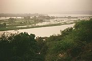
Niger River
The Niger River is the principal river of western Africa, extending about . Its drainage basin is in area. Its source is in the Guinea Highlands in southeastern Guinea...
is navigable 300 km from Niamey
Niamey
-Population:While Niamey's population has grown steadily since independence, the droughts of the early 1970s and 1980s, along with the economic crisis of the early 1980s, have propelled an exodus of rural inhabitants to Niger's largest city...
to Gaya
Gaya, Niger
Gaya is a city in the Dosso Region of Niger. The city is situated 254 km southeast of the capital, Niamey, is located on the banks of the Niger River, and is near the borders with Benin and Nigeria. Gaya has a population of 28,385 . The wettest area in Niger, Gaya averages 800 mm in...
on the Benin
Benin
Benin , officially the Republic of Benin, is a country in West Africa. It borders Togo to the west, Nigeria to the east and Burkina Faso and Niger to the north. Its small southern coastline on the Bight of Benin is where a majority of the population is located...
frontier from mid-December to March. Thereafter a series of falls and rapids render the Niger unnavigable in all seasons. In the navigable stretches, shallows prevent all but the small draft African canoes (Pirogue
Pirogue
A pirogue is a small, flat-bottomed boat of a design associated particularly with the Cajuns of the Louisiana marsh. In West Africa they were used as traditional fishing boats. These boats are not usually intended for overnight travel but are light and small enough to be easily taken onto land...
s and Pinnases) from operating in many areas. As there is only one major bridge over the Niger (The Kennedy Bridge
Kennedy Bridge (Niamey)
The Kennedy Bridge is the main crossing for the Niger River in Niamey, Niger. It was built in 1970, and named for United States President John F. Kennedy. Its construction enabled Niamey to expand onto the right bank of the river to the west...
in Niamey
Niamey
-Population:While Niamey's population has grown steadily since independence, the droughts of the early 1970s and 1980s, along with the economic crisis of the early 1980s, have propelled an exodus of rural inhabitants to Niger's largest city...
: the Niger River bridge at Gaya crosses into Benin), car ferries
Ferry
A ferry is a form of transportation, usually a boat, but sometimes a ship, used to carry primarily passengers, and sometimes vehicles and cargo as well, across a body of water. Most ferries operate on regular, frequent, return services...
are of crucial importance, especially the crossing at Bac Farie, 40 km north of Niamey on the RN4, and the car ferry at Ayorou.
Despite having no ocean or deep draft river ports, Niger does operate a ports authority. Niger relies on the port at Cotonou
Cotonou
-Demographics:*1979: 320,348 *1992: 536,827 *2002: 665,100 *2005: 690,584 The main languages spoken in Cotonou include the Fon language, Aja language, Yoruba language and French.-Transport:...
(Benin
Benin
Benin , officially the Republic of Benin, is a country in West Africa. It borders Togo to the west, Nigeria to the east and Burkina Faso and Niger to the north. Its small southern coastline on the Bight of Benin is where a majority of the population is located...
), and to a lesser degree Lomé
Lomé
Lomé, with an estimated population of 737,751, is the capital and largest city of Togo. Located on the Gulf of Guinea, Lomé is the country's administrative and industrial center and its chief port. The city exports coffee, cocoa, copra, and palm kernels...
(Togo
Togo
Togo, officially the Togolese Republic , is a country in West Africa bordered by Ghana to the west, Benin to the east and Burkina Faso to the north. It extends south to the Gulf of Guinea, on which the capital Lomé is located. Togo covers an area of approximately with a population of approximately...
), and Port Harcourt (Nigeria
Nigeria
Nigeria , officially the Federal Republic of Nigeria, is a federal constitutional republic comprising 36 states and its Federal Capital Territory, Abuja. The country is located in West Africa and shares land borders with the Republic of Benin in the west, Chad and Cameroon in the east, and Niger in...
), as its main route to overseas trade. Abidjan
Abidjan
Abidjan is the economic and former official capital of Côte d'Ivoire, while the current capital is Yamoussoukro. it was the largest city in the nation and the third-largest French-speaking city in the world, after Paris, and Kinshasa but before Montreal...
was is in the process of regaining Niger's port trade, following the disruption of the Ivorian Civil War, beginning in 1999. Niger operates a Nigerien Ports Authority station, as well as customs and tax offices in a section of Cotonou's port, so that imports and exports can be directly transported between Gaya
Gaya, Niger
Gaya is a city in the Dosso Region of Niger. The city is situated 254 km southeast of the capital, Niamey, is located on the banks of the Niger River, and is near the borders with Benin and Nigeria. Gaya has a population of 28,385 . The wettest area in Niger, Gaya averages 800 mm in...
and the port. French Uranium mines in Arlit
Arlit
Arlit is an industrial town and capital of the Arlit Department of the Agadez Region of northern-central Niger, built between the Sahara desert and the eastern edge of the Aïr mountains. It is 200 km south by road from the border with Algeria...
, which produce Niger's largest exports by value, travel through this port to France or the world market.
Airports
The US government estimated there were 27 airports and/or landing strips in Niger as of 2007. Nine (9) of these had paved runways, 18 with unpaved landing strips. ICAO Codes for Niger are prefixed "DR".Of the 9 Airports with paved runway
Runway
According to ICAO a runway is a "defined rectangular area on a land aerodrome prepared for the landing and take-off of aircraft." Runways may be a man-made surface or a natural surface .- Orientation and dimensions :Runways are named by a number between 01 and 36, which is generally one tenth...
s, 2 with paved strips from 2,438 to 3,047 m: Diori Hamani International Airport
Diori Hamani International Airport
Diori Hamani International Airport is an airport in Niamey, the capital of Niger. It is located in the south eastern suburbs of the city, along the Route Nationale 1, the major highway linking Niamey with the east of the nation. The airport complex also includes the major base for the Armed Forces...
and Mano Dayak International Airport
Mano Dayak International Airport
Mano Dayak International Airport is an airport in Agadez in Niger.- External links :*...
. These are the only two Nigerien airports with regular international commercial flights. Six of the remainder have strips between 1,524 and 2,437 m, while one is under 914 m. 18 additional airports have unpaved runways 15 of them with strips between 914 and 1,523 m.
Major airports (with ICAO code
International Civil Aviation Organization airport code
The ICAO airport code or location indicator is a four-character alphanumeric code designating each airport around the world. These codes are defined by the International Civil Aviation Organization, and published in ICAO Document 7910: Location Indicators.The ICAO codes are used by air traffic...
and IATA code
IATA code
IATA codes are abbreviations that the International Air Transport Association publishes to facilitate air travel. They are typically 1-, 2-, 3-, or 4-character combinations that uniquely identify locations, equipment, companies, and times to standardize international flight operations...
) include:
- DRRM (MFQ) – Maradi AirportMaradi Airport- Airlines and destinations :There are currently no scheduled airlines serving the airport .-Former airlines and destinations:* Arik Air - Niamey [ceased operations in February 2010]...
– Maradi - DRRN (NIM) – Diori Hamani International AirportDiori Hamani International AirportDiori Hamani International Airport is an airport in Niamey, the capital of Niger. It is located in the south eastern suburbs of the city, along the Route Nationale 1, the major highway linking Niamey with the east of the nation. The airport complex also includes the major base for the Armed Forces...
– NiameyNiamey-Population:While Niamey's population has grown steadily since independence, the droughts of the early 1970s and 1980s, along with the economic crisis of the early 1980s, have propelled an exodus of rural inhabitants to Niger's largest city... - DRRT (THZ) – Tahoua AirportTahoua Airport- Airlines and destinations :* Arik Air...
– TahouaTahouaTahoua is a city in Niger and the administrative center of the Department of Tahoua and the larger Tahoua Region. It has a population of 99,900 . The city is primarily a market town for the surrounding agricultural area, and a meeting place for the Tuareg people from the north and the Fulani people... - DRZA (AJY) – Mano Dayak International AirportMano Dayak International AirportMano Dayak International Airport is an airport in Agadez in Niger.- External links :*...
– AgadezAgadez-Sources:* Aboubacar Adamou. "Agadez et sa région. Contribution à l'étude du Sahel et du Sahara nigériens", Études nigériennes, n°44, , 358 p.* Julien Brachet. Migrations transsahariennes. Vers un désert cosmopolite et morcelé . Paris: Le Croquant, , 324 p. ISBN : 978-2-91496865-2.*. Saudi Aaramco...
South - DRZL (RLT) – Arlit AirportArlit AirportArlit Airport is an airport serving Arlit in Niger....
– ArlitArlitArlit is an industrial town and capital of the Arlit Department of the Agadez Region of northern-central Niger, built between the Sahara desert and the eastern edge of the Aïr mountains. It is 200 km south by road from the border with Algeria... - DRZR (ZND) – Zinder AirportZinder Airport- Airlines and destinations :There are currently no scheduled airlines serving the airport .-Former airlines and destinations:...
– ZinderZinderZinder is the second largest city in Niger, with a population of 170,574 by 2005 was estimated to be over 200,000... - DRZF – Diffa AirportDiffa AirportDiffa Airport is an airport serving Diffa in Niger....
– DiffaDiffaDiffa is a city and Urban Commune in the extreme southeast of Niger, near that country's border with Nigeria, with a population of 23,600 . It is the administrative seat of both Diffa Region, and the smaller Diffa Department... - DRZD – Dirkou AirportDirkou AirportDirkou Airport is an airport serving Dirkou in Niger....
– DirkouDirkouDirkou is a town in the Bilma Department, Agadez Region of north-eastern Niger. It lies in the northern Kaouar escarpment, a north-south line of cliffs which form an isolated oasis in the Sahara desert.... - DRRB (BKN) – Birni N'Konni Airport – Birni N'Konni
Other airstrips (with ICAO codes
International Civil Aviation Organization airport code
The ICAO airport code or location indicator is a four-character alphanumeric code designating each airport around the world. These codes are defined by the International Civil Aviation Organization, and published in ICAO Document 7910: Location Indicators.The ICAO codes are used by air traffic...
) include:
- DRRI BilmaBilmaBilma is an oasis town in north east Niger with a population of around 2,500 people. It lies protected from the desert dunes under the Kaouar Cliffs and is the largest town along the Kaouar escarpment...
- DRRC DogondoutchiDogondoutchiDogondoutchi is a city located in the east of the Dosso Region of Niger. With a population of 29,244 , Dogondoutchi is the largest city in and administrative center of the Dogondoutchi department, the easternmost section of Dosso Region....
- DRRD DossoDosso, NigerDosso is a town in the south-west corner of Niger. It lies 130–140 km south-east of the capital Niamey at the junction of the main routes to Zinder and Benin. The seventh most populous town in Niger and the largest in Dosso Region, it had an official population during the 2001 census of 43,561...
- DRRG GayaGaya, NigerGaya is a city in the Dosso Region of Niger. The city is situated 254 km southeast of the capital, Niamey, is located on the banks of the Niger River, and is near the borders with Benin and Nigeria. Gaya has a population of 28,385 . The wettest area in Niger, Gaya averages 800 mm in...
- DRZG GoureGoureGoure is a town in southeastern Niger, Zinder Region, Goure Department, of which it is the seat.-Situation:Situated on the main all weather east - west highway in Southern Niger, it is about 170 km east of regional capital, Zinder, on the route east to Diffa, N'Guigmi, and the Lake Chad area...
- DRZI IferouaneIferouaneIferouane , also spelled Iferouan, is an oasis town in northern Niger, in Agadez Department. It is located northeast of Arlit in the northern Aïr,in the Ighazar valleynear the Tamgak Range....
- DRRP La TapoaLa TapoaLa Tapoa is a town on the Niger River in the Tillabéri Region of south-western Niger....
- DRZM Maine Soroa
- DRZN N'guigmiN'guigmiN'guigmi is a city and Commune of fifteen thousand in the eastern most part of Niger, very near to Lake Chad - lying on its shore until the lake retreated....
- DRRU OuallamOuallamOuallam is a town in southwestern Niger. It is around 300 km north of Niamey, is the capital of Ouallam Department, one of four in the Tillabery Region.-Culture:...
- DRZT TanoutTanoutTanout is a town in southern Niger. It is in Zinder Region, Tanout Department, north of the city of Zinder. It is the administrative capital of Tanout Department....
- DRRA TessaouaTessaouaTessaoua is a city located in the Maradi Region of Niger. It has a population of 31,667 . Tessaoua is historically an important city in its region. It is situated in a central geographical location. Tessaoua is a mid-point on a historical trade route between Agadez, Niger in the north and Kano,...
- DRRE TéraTéraTéra is a town in the Tillabéri Region, Tera Department of Niger. It is situated 175 km north-west of the capital Niamey, close to the border with Burkina Faso. It is mainly inhabited by Songhai, Fulani, Gourmantche and Buzu ethnic groups. The majority of the population are farmers.- Commerce...
- DRRL Tillabery
Railway
There are no railways in Niger, although Niger is a user of the Benin and Togo railway lines which carry goods from seaports to the Niger border. Rail lines to NiameyNiamey
-Population:While Niamey's population has grown steadily since independence, the droughts of the early 1970s and 1980s, along with the economic crisis of the early 1980s, have propelled an exodus of rural inhabitants to Niger's largest city...
and other points in Niger were proposed during the colonial period, and continue to be discussed.
Possible rail links projects
NigeriaTransport in Nigeria
Decaying infrastructure is one of the deficiencies that Nigeria’s National Economic Empowerment Development Strategy seeks to address. The government has begun to repair the country’s poorly maintained road network. Because Nigeria’s railways are in a parlous condition, the government is trying...
- no - (cape gauge
Cape gauge
Cape gauge is a track gauge of between the inside of the rail heads and is classified as narrow gauge. It has installations of around .The gauge was first used by Norwegian engineer Carl Abraham Pihl and the first line was opened in 1862.- Nomenclature :...
) Benin
Transport in Benin
This article concerns modes of transport in Benin. Benin is a country in Africa, which possesses railway and road infrastructure, as well as two seaports. Benin currently does not have rail connections to other countries, but new proposals seek to change this....
- no - Mali
Transport in Mali
Mali's transportation infrastructure is regarded as poor, even by regional standards, and deficiencies have limited economic growth and development. Nevertheless, improvements have been noted in the early 2000s...
- no - Algeria
Transport in Algeria
- Railways :There are a total of 3,973 km of railways: 2,888 km is standard gauge, with 283 km of that being electrified and 215 km of that being double tracked...
- no - (Standard gauge
Standard gauge
The standard gauge is a widely-used track gauge . Approximately 60% of the world's existing railway lines are built to this gauge...
) Libya
Transport in Libya
-Railways:Libya has had no railway in operation since 1965, all previous narrow gauge lines having been dismantled. Plans for a new network have been under development for some time , and in 2008 and 2009 various contracts were placed and construction work started on a standard gauge railway...
- no - - under construction
Gauge
Were any railways in Niger to interconnect with railways of adjacent countries, choosing the best gauge will be tricky. matches the gauge of the regional powerhouse of Nigeria, although Nigeria has ambitious plans to convert to . matches the gauge of North Africa and Europe. , while quite common, is fragmented and used by minor countries. Fortunately, it is possible to build plain track suitable for all three (see Dual gauge).Niger would be a participant in the AfricaRail
AfricaRail
AfricaRail is a project to link the railway systems of Ivory Coast, Burkina Faso, Niger, Benin and Togo. All these systems are .A future stage would link Mali, Senegal, Nigeria and Ghana which are of , , changing all to...
project. With gauge railways seemingly under construction in Libya to the north and Nigeria to the south, and an interconnection between the two that quite likely would pass through Nigeria, this would seem to indicate that Niger will acquire standard gauge
Standard gauge
The standard gauge is a widely-used track gauge . Approximately 60% of the world's existing railway lines are built to this gauge...
railways. This would scuttle in part at least proposals to create a gauge network joining Niger with Togo, Benin and beyond. Considering the amount of new construction needed to link such countries, and the construction of a number of heavy duty iron ore railways which would almost certainly be gauge, momentum is created to adopt the gauge throughout.
An Indian proposal has surfaced to link the railways in Benin and Togo with landlocked Niger and Burkino Faso. This network skirts around Ghana
Transport in Ghana
Transport in Ghana is accomplished by road, rail, air and water. Ghana's transportation and communications networks are centered in the southern regions, especially the areas in which gold, cocoa, and timber are produced...
which is the wrong narrow gauge
Narrow gauge
A narrow gauge railway is a railway that has a track gauge narrower than the of standard gauge railways. Most existing narrow gauge railways have gauges of between and .- Overview :...
of . On 6 March 2006 a scheme to extend the Nigerian rail system to neighbouring Niger, conceived 10 years ago, was revived and is currently receiving consideration by the transport ministries of both governments. The route identified runs from the present Nigerian railhead at
Kaura-Namoda via Sokoto
Sokoto
Sokoto is a city located in the extreme northwest of Nigeria, near to the confluence of the Sokoto River and the Rima River. As of 2006 it has a population of 427,760...
to Birnin-Konni (about 250 km altogether) on the border with Niger, which has no railway. A feasibility study on has been carried out by consultants Team (Nig) Ltd of Nigeria; the only obstacle now is the lack of funds. It is hoped that donor agencies will assist. Nigeria is already using gauge convertible sleepers on the Onne
Onne
Onne is a port of Nigeria.Onne is situated at Ogu Creek, a side-arm to Bonny River. It is part of the Odido Clan in the Eleme Local Government Area of Nigeria. It is a major port in the region and has several quays with facilities for cargoships up to 60,000 grt...
line, and would presumably use them on the Niger Extension, so that initially 1067mm gauge would be used with easy conversion to at a later date. Triple gauge sleepers that can also support are also possible.