

Transport in Ghana
Encyclopedia
Ghana
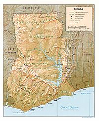
Ghana , officially the Republic of Ghana, is a country located in West Africa. It is bordered by Côte d'Ivoire to the west, Burkina Faso to the north, Togo to the east, and the Gulf of Guinea to the south...
is accomplished by road, rail, air and water. Ghana's transportation and communications networks are centered in the southern regions, especially the areas in which gold, cocoa, and timber are produced. The northern and central areas are connected through a major road system; some areas, however, remain relatively isolated.
The deterioration of the country's transportation and communications networks has been blamed for impeding the distribution of economic inputs and food as well as the transport of crucial exports. Consequently, the first priority of the ERP was to repair physical infrastructure. Under the program's first phase (1983–86), the government allocated US$1.5 billion, or 36 percent of total investment, for that purpose and an additional US$222 million in 1987 for road and rail rehabilitation. In 1991 the Ghanaian government allocated 27 percent of its budget for various road schemes.
Foreign donor support helped to increase the number of new vehicle registrations from 8,000 in 1984 to almost 20,000 in 1989. The distribution of vehicles was skewed, however, because, by 1988, more than half of all vehicles were in Accra, which contained approximately 7 percent of the country's population. Furthermore, most new vehicles are intended for private use rather than for hauling goods and people, a reflection of income disparities. Transportation is especially difficult in eastern regions, near the coast, and in the vast, underdeveloped northern regions, where vehicles are scarce. At any one time, moreover, a large percentage of intercity buses and Accra city buses are out of service.
Railways
The railway system in Ghana has historically been confined to the plains south of the barrier range on mountains north of the city of KumasiKumasi
Kumasi is a city in southern central Ghana's Ashanti region. It is located near Lake Bosomtwe, in the Rain Forest Region about northwest of Accra. Kumasi is approximately north of the Equator and north of the Gulf of Guinea...
. However, the narrow gauge railway, totalling 935 kilometres, is presently undergoing major rehabilitation and inroads to the interior are now being made. In Ghana, most of the lines are single tracked, and in 1997 it was estimated that 32 kilometres were double tracked.

Rail expansion initiatives
In 2005 the Minister of Ports, Harbours and Railways announced plans to extend the railway system to facilitate economic development. To begin, $5 million was sought from the African Development BankAfrican Development Bank
The African Development Bank Group is a development bank established in 1964 with the intention of promoting economic and social development in Africa...
(ADB) for feasibility studies. Possible projects at the time included extending a line from Ejisu
Ejisu
Ejisu is a town and seat of Ejisu-Juaben Municipal District in Ghana....
to Nkoranza
Nkoranza
Nkoranza is a town located in the mid-north of Ghana. It is the district capital of the Nkoranza District in the Brong-Ahafo Region.A leading Brong town, the town led the 1892-93 Brong rebellion against the Ashanti.- Transport :...
and Techiman
Techiman
Techiman is the leading market town in Ghana and is, together with Sunyani, one of the two chief cities of the Brong-Ahafo Region. This city of nearly 80,000 is located at a historical crossroads of trade routes and the Tano River, and serves as capital of the Techiman Municipal...
; a line from Tamale
Tamale, Ghana
Tamale with a population of 360,579 , is the capital of the Northern Region of Ghana and the Tamale Metropolitan District with which it is coterminous Area. The city is located 600 km north of Accra...
to Bolgatanga
Bolgatanga
Bolgatanga, colloquially known as Bolga, is the capital of both the Bolgatanga Municipal District and the Upper East Region of Ghana, and has a population of about 72,000...
and Paga
Paga
Paga is a town in northern Ghana, lying where the nation's main north-south road reaches the Burkina Faso border, north of Bolgatanga. There are plans to extend the Kumasi-Takoradi railway to Paga.- Overview :...
to Burkina Faso
Burkina Faso
Burkina Faso – also known by its short-form name Burkina – is a landlocked country in west Africa. It is surrounded by six countries: Mali to the north, Niger to the east, Benin to the southeast, Togo and Ghana to the south, and Côte d'Ivoire to the southwest.Its size is with an estimated...
; a line from Wenchi
Wenchi
Wenchi is a town in Ghana located at 7.73333 [latitude in decimal degrees], -2.1 [longitude in decimal degrees] at an elevation/altitude of meters. The average elevation of Wenchi, Ghana is 304 meters. The town is approximately 30 km north of Techiman on the Wa road and about 50 km east...
, Bole
Bole, Ghana
Bole is a town in the Northern Region of Ghana. It is connected by road to the towns of Sawla and Bamboi, and Bouna in the Ivory Coast. Bole is home to a number of refugees from the civil war in the Ivory Coast....
to Wa
Wa, Ghana
Wa is the capital of the Upper West Region of Ghana and is the main city of the Wala people. The majority of the inhabitants are Muslim. It is the seat of the Wa-Na, the Paramount Chief of the Wala traditional area. Features of the town include several mosques, the Wa-Na Palace, a museum and a...
and Hamile
Hamile
Hamile is a town in far northwestern Ghana, not far from the border with Burkina Faso.- Transport :In July 2007, contracts were made for the construction of a railway extension to this town.- External links :...
and also to Burkina Faso
Burkina Faso
Burkina Faso – also known by its short-form name Burkina – is a landlocked country in west Africa. It is surrounded by six countries: Mali to the north, Niger to the east, Benin to the southeast, Togo and Ghana to the south, and Côte d'Ivoire to the southwest.Its size is with an estimated...
, and a line to Yendi
Yendi
Yendi is a town in the northeastern quadrant of Ghana in the Dagbon territory. As of 2000, it has a population of 40,336 people. Yendi is the traditional capital of the Dagbon Kingdom with the Ya Na as the Overlord. The people of Dagbon are called Dagombas or Dagbamba...
where there are iron ore deposits.
Over the next two years, there were various studies and in 2007, work began.

Ejisu
Ejisu is a town and seat of Ejisu-Juaben Municipal District in Ghana....
and Kumasi
Kumasi
Kumasi is a city in southern central Ghana's Ashanti region. It is located near Lake Bosomtwe, in the Rain Forest Region about northwest of Accra. Kumasi is approximately north of the Equator and north of the Gulf of Guinea...
, with an extension from Ejisu
Ejisu
Ejisu is a town and seat of Ejisu-Juaben Municipal District in Ghana....
via Mampong
Mampong
Mampong is a town in Ghana. It is found in the Ashanti Region in Ghana, and serves as the administrative capital of Sekyere West District.It is also the home of the Mampong Centre for Scientific Research into Plant Medicine. The center conducts research in the use of plant medicine in the cure of...
, Nkoranza
Nkoranza
Nkoranza is a town located in the mid-north of Ghana. It is the district capital of the Nkoranza District in the Brong-Ahafo Region.A leading Brong town, the town led the 1892-93 Brong rebellion against the Ashanti.- Transport :...
, Tamale
Tamale
A tamale — or more correctly tamal — is a traditional Latin American dish made of masa , which is steamed or boiled in a leaf wrapper. The wrapping is discarded before eating...
, Bolgatanga
Bolgatanga
Bolgatanga, colloquially known as Bolga, is the capital of both the Bolgatanga Municipal District and the Upper East Region of Ghana, and has a population of about 72,000...
and Paga
Paga
Paga is a town in northern Ghana, lying where the nation's main north-south road reaches the Burkina Faso border, north of Bolgatanga. There are plans to extend the Kumasi-Takoradi railway to Paga.- Overview :...
, with a branch from Tamale
Tamale
A tamale — or more correctly tamal — is a traditional Latin American dish made of masa , which is steamed or boiled in a leaf wrapper. The wrapping is discarded before eating...
to Yendi
Yendi
Yendi is a town in the northeastern quadrant of Ghana in the Dagbon territory. As of 2000, it has a population of 40,336 people. Yendi is the traditional capital of the Dagbon Kingdom with the Ya Na as the Overlord. The people of Dagbon are called Dagombas or Dagbamba...
and Sheini. The extension starts at Kumasi
Kumasi
Kumasi is a city in southern central Ghana's Ashanti region. It is located near Lake Bosomtwe, in the Rain Forest Region about northwest of Accra. Kumasi is approximately north of the Equator and north of the Gulf of Guinea...
and will cost $1.6b.
There was another proposal in September 2007 to extend the Western Railway from Awaso
Awaso
Awaso is a town in western Ghana.It has a bauxite mine operated by the Ghana Bauxite Company. The mine is served by a rail branch line on the western Ghana rail system, however in 2007 much of the ore goes by road....
via Techiman
Techiman
Techiman is the leading market town in Ghana and is, together with Sunyani, one of the two chief cities of the Brong-Ahafo Region. This city of nearly 80,000 is located at a historical crossroads of trade routes and the Tano River, and serves as capital of the Techiman Municipal...
, Bole
Bole, Ghana
Bole is a town in the Northern Region of Ghana. It is connected by road to the towns of Sawla and Bamboi, and Bouna in the Ivory Coast. Bole is home to a number of refugees from the civil war in the Ivory Coast....
, Sawla
Sawla
Sawla is a town in southern Ethiopia. Located in the Gamo Gofa Zone of the Southern Nations, Nationalities and Peoples' Region, this town has a latitude and longitude of with an altitude of 1395 meters above sea level...
, Wa
Wa, Ghana
Wa is the capital of the Upper West Region of Ghana and is the main city of the Wala people. The majority of the inhabitants are Muslim. It is the seat of the Wa-Na, the Paramount Chief of the Wala traditional area. Features of the town include several mosques, the Wa-Na Palace, a museum and a...
to Hamile
Hamile
Hamile is a town in far northwestern Ghana, not far from the border with Burkina Faso.- Transport :In July 2007, contracts were made for the construction of a railway extension to this town.- External links :...
.
In February 2008 the Ghana General News reported that the Ministry of Harbours and Railways and the Ghana Railway Corporation (GRC) expected to complete a new commuter line linking Accra
Accra
Accra is the capital and largest city of Ghana, with an urban population of 1,658,937 according to the 2000 census. Accra is also the capital of the Greater Accra Region and of the Accra Metropolitan District, with which it is coterminous...
and Tema
Tema
Tema is a city on the Atlantic coast of Ghana, lying east of the Ghanaian capital city, Accra, in the region of Greater Accra. As of 2005, Tema had a population of 209,000. The Greenwich Meridian passes directly through the city...
by June 2008. The formation was complete from Sakumono
Sakumono
Sakumono was originally a small fishing village on a lagoon, but by 2008 is being swallowed up as the twin cities of Accra and Tema merge. Elevation is 71m.- External links :* *...
to the SSNIT flats near Tema. Diesel multiple-unit trainsets will be imported for use on the line. Construction of sleeper plant for the far north line was also initiated in 2008.
Service pending
These towns are proposed to be served by rail:- EjisuEjisuEjisu is a town and seat of Ejisu-Juaben Municipal District in Ghana....
- KintampoKintampoThe Kintampo archeological site in Ghana dates back to 2500-1400 BCE and is one of the earliest known sites for the cultivation of the cowpea. Evidence of polished stone axes, stone beads, buildings of stone, domestic pots, ceramic sculptures of humans and animals indicate that Kintampo was...
- PagaPagaPaga is a town in northern Ghana, lying where the nation's main north-south road reaches the Burkina Faso border, north of Bolgatanga. There are plans to extend the Kumasi-Takoradi railway to Paga.- Overview :...
- near Burkina Faso and Côte d'Ivoire borders. - HamileHamileHamile is a town in far northwestern Ghana, not far from the border with Burkina Faso.- Transport :In July 2007, contracts were made for the construction of a railway extension to this town.- External links :...
- far northwest corner (Contracts were made for railway extensions in July 2007.)
- Boankra Inland PortBoankra Inland PortThe Boankra Inland Port is a Dry port under construction near the Ghanaian city of Kumasi.- External links :* - External links :*...
(under construction)
Gauge conversion
Korean engineers studying the building of new lines in February 2007 were also to consider conversion to standard gaugeStandard gauge
The standard gauge is a widely-used track gauge . Approximately 60% of the world's existing railway lines are built to this gauge...
.
Highways
Trunk roads in Ghana are classified as National roads, Regional roads, and Inter-regional roads, all of which form the Ghana road network
Ghana road network
The Ghana Road Network is maintained by the Ghana Highway Authority, which was established in 1974 to develop the country's trunk road network totaling 13,367 km. This makes up 33% of Ghana's total road network of 40,186 km...
. National roads, designated with the letter N, link all the major population centers in Ghana. Regional roads, designated with the letter R, are a mix of primary and secondary routes, which serve as feeder roads to National roads; while Inter-Regional roads, designated with the prefix IR, connect major settlements across regional borders. By virtue of National roads linking major cities in the country, they sometimes double as Regional and Inter-Regional roads. The R40, which connects Accra to Adenta through the Tetteh Quarshie Interchange, forms part of the N4 which links Accra to Koforidua and Kumasi through the Tetteh Quarshie Interchange.
With respect to this mode of transport, many people prefer to use the public means. Many of the town and cities in the country can be reached by the use of urvan buses known as "trotro" or taxis. For inter-regional transport bigger buses are normally used.
International highways
The Trans–West African Coastal Highway, part of the Trans-African Highway networkTrans-African Highway network
The Trans-African Highway network comprises transcontinental road projects in Africa being developed by the United Nations Economic Commission for Africa , the African Development Bank , and the African Union in conjunction with regional international communities...
crosses Ghana along the N1, connecting it to Abidjan
Abidjan
Abidjan is the economic and former official capital of Côte d'Ivoire, while the current capital is Yamoussoukro. it was the largest city in the nation and the third-largest French-speaking city in the world, after Paris, and Kinshasa but before Montreal...
, (Côte d'Ivoire
Côte d'Ivoire
The Republic of Côte d'Ivoire or Ivory Coast is a country in West Africa. It has an area of , and borders the countries Liberia, Guinea, Mali, Burkina Faso and Ghana; its southern boundary is along the Gulf of Guinea. The country's population was 15,366,672 in 1998 and was estimated to be...
), Lomé
Lomé
Lomé, with an estimated population of 737,751, is the capital and largest city of Togo. Located on the Gulf of Guinea, Lomé is the country's administrative and industrial center and its chief port. The city exports coffee, cocoa, copra, and palm kernels...
, (Togo
Togo
Togo, officially the Togolese Republic , is a country in West Africa bordered by Ghana to the west, Benin to the east and Burkina Faso to the north. It extends south to the Gulf of Guinea, on which the capital Lomé is located. Togo covers an area of approximately with a population of approximately...
) as well as Benin
Benin
Benin , officially the Republic of Benin, is a country in West Africa. It borders Togo to the west, Nigeria to the east and Burkina Faso and Niger to the north. Its small southern coastline on the Bight of Benin is where a majority of the population is located...
and Nigeria
Nigeria
Nigeria , officially the Federal Republic of Nigeria, is a federal constitutional republic comprising 36 states and its Federal Capital Territory, Abuja. The country is located in West Africa and shares land borders with the Republic of Benin in the west, Chad and Cameroon in the east, and Niger in...
. Eventually the highway will connect to another seven ECOWAS nations to the west. The N2, which connects Tema in the Greater Accra Region to Kulungugu in the Upper East Region; the N10, which connects Yamoransa in the Central Region to Paga in the Upper East Region; and the N12, which connects Elubo in the Western Region to Hamile in the Upper West Region; all connect Ghana to landlocked Burkina Faso
Burkina Faso
Burkina Faso – also known by its short-form name Burkina – is a landlocked country in west Africa. It is surrounded by six countries: Mali to the north, Niger to the east, Benin to the southeast, Togo and Ghana to the south, and Côte d'Ivoire to the southwest.Its size is with an estimated...
, where it joins another highway in the Trans-African network, the Trans-Sahelian Highway
Trans-Sahelian Highway
The Trans-Sahelian Highway or Trans-Sahel Highway is a transnational highway project to pave, improve and ease border formalities on a highway route through the southern fringes of the Sahel region in West Africa between Dakar, Senegal in the west and Ndjamena, Chad, in the east...
.
Ferries and waterways
The VoltaVolta River
The Volta is a river in western Africa that drains into the Gulf of Guinea. It has three main tributaries—the Black Volta, White Volta and Red Volta...
, Ankobra
Ankobra River
The Ankobra River is situated in Western Africa. Rising north east of Wiawso, it flows about 120 miles south to the Gulf of Guinea. Its entire course is in southern Ghana...
, and Tano
Tano River
The Tano or Tanoé River is a river in Ghana. It flows for 400 kilometres from Techiman to Ehy, Tendo and finally Aby Lagoon where it enters the Atlantic Ocean...
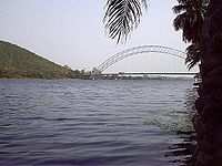
rivers provide 168 km of perennial navigation for launches and lighters; Lake Volta provides 1,125 kilometres of arterial and feeder waterway.
There are ferries on Lake Volta at Yeji
Yeji
Yeji is a city in the Brong-Ahafo Region of Ghana. It is in the north-east of the region, and is adjacent to Lake Volta. Yeji is connected by a ferry to the town of Salaga, and by highway to Ejura and Kwadjokrom.-External links:*...
and Kwadjokrom
Kwadjokrom
Kwadjokrom is a city in the Brong-Ahafo Region of Ghana. It is in the east of the region, and is situated by Lake Volta. Kwadjokrom is connected by a ferry to the town of Kete Krachi, and by road to Ejura and Yeji....
.
Merchant marine
There are six ships (with a volume of or over) totaling /. This includes two petroleum tankerOil tanker
An oil tanker, also known as a petroleum tanker, is a merchant ship designed for the bulk transport of oil. There are two basic types of oil tankers: the crude tanker and the product tanker. Crude tankers move large quantities of unrefined crude oil from its point of extraction to refineries...
s and four refrigerated cargo vessels (1999 estimates).
Aviation
On July 4, 1958, the Ghanaian government established Ghana AirwaysGhana Airways
Ghana Airways Limited was the national airline of the Republic of Ghana with its main base of operation, and hub, at Kotoka International Airport in Accra....
to replace the former African Airways Corporation. By the mid-1990s, Ghana Airways operated international scheduled passenger and cargo service to numerous European, Middle Eastern, and African destinations, including London, Düsseldorf, Rome, Abidjan, Dakar, Lagos, Lomé, and Johannesburg. Ghana Airways ceased all operations and entered into liquidation in 2004.
In 2005, Ghana International Airlines
Ghana International Airlines
Ghana International Airlines was the national airline of the Republic of Ghana. The airline suspended operations on 13 May 2010..GIA operated scheduled and charter passenger and cargo services...
(GIA) began operations as the new national airline of Ghana. GIA presently operates Boeing 757
Boeing 757
The Boeing 757 is a mid-size, narrow-body twin-engine jet airliner manufactured by Boeing Commercial Airplanes. Passenger versions of the twinjet have a capacity of 186 to 289 persons and a maximum range of , depending on variant and cabin configuration...
aircraft and connects Kotoka International Airport
Kotoka International Airport
Kotoka International Airport in Accra, Ghana, is the country's premier international airport and has the capacity for large aircraft such as the Boeing 747-800...
in Accra with London Gatwick and Düsseldorf
Düsseldorf
Düsseldorf is the capital city of the German state of North Rhine-Westphalia and centre of the Rhine-Ruhr metropolitan region.Düsseldorf is an important international business and financial centre and renowned for its fashion and trade fairs. Located centrally within the European Megalopolis, the...
.
Ghana has twelve airports, six with hard surfaced runways. The most important are Kotoka International Airport
Kotoka International Airport
Kotoka International Airport in Accra, Ghana, is the country's premier international airport and has the capacity for large aircraft such as the Boeing 747-800...
at Accra and airports at Sekondi-Takoradi, Kumasi, and Tamale that serve domestic air traffic. In 1990, the government spent US$12 million to improve Accra's facilities. Workmen resurfaced the runway, upgraded the lighting system, and built a new freight terminal. Construction crews also extended and upgraded the terminal building at Kumasi. In early 1991, the government announced further plans to improve Accra's international airport. The main runway was upgraded, improvements were made in freight landing and infrastructure, and the terminal building and the airport's navigational aids were upgraded.
Airports - with paved runways
Kotoka International AirportKotoka International Airport
Kotoka International Airport in Accra, Ghana, is the country's premier international airport and has the capacity for large aircraft such as the Boeing 747-800...
total:
6
2,438 to 3,047 m:
1
1,524 to 2,437 m:
3
914 to 1,523 m:
2 (1999 est.)
Airports - with unpaved runways
total:6
1,524 to 2,437 m:
1
914 to 1,523 m:
3
under 914 m:
2