
Transport in Guyana
Encyclopedia
The transport
sector comprises the physical facilities, terminals, fleets and ancillary equipment of all the various modes of transport operating in Guyana
, the transport services, transport agencies providing these services, the organizations and people who plan, build, maintain, and operate the system, and the policies that mold its development.
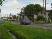 Public transport around Guyana's capital Georgetown
is provided by privately owned mini buses which operate in allocated zones for which there is a well-regulated fare structure. This arrangement extends to all mini bus routes throughout the country. There are few designated stopping points for mini buses, which will pick up passengers at virtually any point on their routes. This practice often poses a serious inconvenience to other vehicles.
Taxis have freer movement around the city and into rural areas. Their fare, while generally standard, is less regulated. Starting in 2010, all taxis must be painted yellow, a regulation designed to protect consumers and to distinguish the vehicles from others that are often used in committing crimes. All taxis are registered under the term "Hackney Carriage" and carry the letter H at the beginning of their number plates.
The network of routes has a number of identifiable starting points which are concentrated in the Stabroek area and along the Avenue of the Republic between Croal and Robb Streets.
Road conditions vary immensely, and maintenance is sometimes deficient. In 2006 there was one operational set of traffic lights but in July 2007, a modern system was installed by Indian firm CMS Traffic Systems Limited, through a US$2.1 million line of credit to the government from India’s EXIM Bank, providing signals for both vehicular and pedestrian traffic.
 In 2004, Guyana's road network was approximately 3995 kilometres (2,482.4 mi) long, 24 percent or 940 kilometers of which comprised primary roads in the coastal and riverine areas serving the agricultural sector, while the road
to Linden
serves the mining and forestry sectors. 21 percent (820 kilometers) is made up of feeder roads that link the agricultural areas along the coast to the primary road network. The remaining 56 percent (2,235 kilometers) is composed of interior roads and trails. Most access roads are in poor condition. However, the Central Government has targeted several roads for complete rehabilitation, and already many have been rehabilitated.
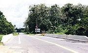
The main coastal roads are, from west to east, the Essequibo Coast Road, the Parika
to Vreed en Hoop
Road, the East Coast Demerara and West Coast Berbice Roads, and the Corentyne Highway from New Amsterdam
to Moleson Creek
(86 kilometres). All these roads are paved.
South of Georgetown the primary road is the East Bank Demerara Road, a two-lane road that runs from Georgetown to Timehri, where the Cheddi Jagan International Airport
- Timehri (CJIAT) is located.
Between 1966 and 1968, Soesdyke, located on the East Bank Demerara Road, was connected to Mackenzie by a modern two lane highway, called the Soesdyke-Linden Highway
. This road was constructed as a section of a highway connecting Georgetown with Lethem
. In 1968 a bridge was built across the Demerara River
at Linden
, and, in 1974, it was decided that the route to Lethem would cross the Demerara River at Linden and go south, along the watershed of the Demerara and Essequibo Rivers, through Mabura, to Kurupukari. From Kurupukari it would run parallel to the old cattle trail to Annai
, and from Annai it would follow an already existing road to Lethem.
 In the early 1970s a two-lane road with modern geometry and surfaced with laterite
was built between Linden and Rockstone
. This road was later connected to Mabura and Kurupukari. In 1990-91 a two-lane laterite road was constructed between Kurupukari and Annai and a vehicle ferry installed at Kurupukari. Since there was already an existing road between Mabura and Kurupukari, and between Annai and Lethem, it was now possible for vehicles to travel between Georgetown and Lethem.
In the period 1974 to 1978, an attempt was made to build a road between Rockstone and Kurupung
to facilitate the construction of a large hydroelectric station. From Rockstone it headed north to Suribanna, where a pontoon ferry was installed across the Essequibo River to Sherima. From Sherima the road went westward, intersecting the Bartica - Mahdia Road at Allsopp Point 19 miles (30.6 km) from Bartica
. From Allsopp Point the road followed the existing road towards Bartica and branched off 5 miles (8 km) from Bartica going to Teperu in the lower reaches on the Mazaruni River. At Teperu a pontoon ferry was installed across the Mazaruni River to Itaballi. From Itaballi the road went westward to Peter's Mine on the Puruni River. From Peter's Mine the road continued as a penetration road to Kurupung. This road is referred to as the UMDA Road.
There is in addition a hinterland east-west main road system that extends from Kwakwani
in the east, through Ituni, Linden, Rockstone, Sherima to Bartica in the west. Linden is therefore one of the main hubs for road transportation in the hinterland.
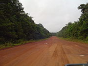
Outside the existing main roads there are several other interior roads or trails that comprise approximately 1,570 kilometres. Most of those roads are unpaved, and will deteriorate if maintenance remains inadequate. They are found mostly in the hinterland and riverain areas and provide linkages with a number of important mining and forestry activities thus facilitating transportation between the mining and forestry communities and the more developed coastal areas. Parts of this road/trail network can be developed into an arterial road system linking the hinterland communities with each other and to the main road network. It is estimated that roads carry 80 percent of Guyana's passenger traffic and about 33 percent of its freight.
Commuters to West Demerara have a choice of road transport via the Demerara Harbour Bridge
or by the Demerara River ferry from the Stabroek Stelling to Vreed en Hoop, which is obliquely opposite.
 The highway that begins on the West Coast of Demerara is heavily trafficked since it provides a link to Parika on the East Bank of the Essequibo River
, which has become an important center of economic activity in the Essequibo region.
It is now possible to travel overland to Suriname
by taking the ferry on the Guyana side at Moleson Creek and crossing the Corentyne River over to Suriname at South Drain
. While travel to Brazil
is via the old cattle trail it has been upgraded into a fair weather track that passes through the bauxite-producing town of Linden and ending at Lethem.
 The coastal main road system is not continuous. There are gaps whenever it intersects the Essequibo, Demerara and Berbice Rivers. People and goods move across these gaps by ferry systems as well as the Demerara Harbour Bridge
(DHB) and the Berbice Bridge
.
The Demerara Harbour Bridge is a two-lane floating bridge, 1.2 miles (1.9 km) long, near the mouth of the Demerara River. It is primarily a low-level bridge which possesses an elevated span with a vertical clearance of 26 feet (7.9 m) in the middle of the river to permit small craft to pass. In addition, across the shipping channel, there are two spans which retract to permit the passage of ocean-going vessels. The DHB is a toll bridge. From mid 1998 toll revenue has been credited to the account of the DHB and not to the Government of Guyana, as it was until then. This is a step towards the establishment of the DHB as an autonomous statutory authority. At present the toll revenue meets the operational and maintenance costs of the bridge.
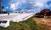
 In 2007, construction resumed on the Takutu River Bridge
to link Guyana and Brazil in the southwest of Guyana near Lethem. The bridge was officially opened on September 14, 2009, enabling economic interests in northern Brazil to link by road to the port at Georgetown. Unprecedented construction and population growth in Lethem since the bridge's opening reflects the significantly increased traffic and movement of goods facilitated by the bridge. The Takutu Bridge is seen as the first of several joint projects between Guyana and Brazil intended to facilitate cargo traffic: Brazil is expected to subsidize the paving of the Lethem-to-Georgetown road, a development that would have profound impacts on the area's economy and environment. Dredging of the Georgetown port to accommodate deeper-draft cargo vessels is also being planned.
services for both passengers and cargo were operated until 1974. Two lines operated - the Demerara-Essequibo Railway, from Vreed en Hoop to Parika (18.5 miles (29.8 km)) and the Demerara-Berbice Railway
, from Georgetown to Rosignol (65 miles (104.6 km)). With the upgrading of the West Coast Demerara/East Bank Essequibo and the East Coast Demerara/West Coast Berbice roadways, the Government decided in mid 1970s to cease operating the railway services, which were being run at a loss. In the Matthew's Ridge
area, there is a 32 miles (51.5 km) railway service.
A railway service was once operated in Linden for the movement of bauxite ore. However trucks are now used to transport the bauxite ore.
The infrastructure that supports water transport in Guyana is located along the banks of the navigable rivers, namely, the Essequibo River, Demerara River and Berbice River. In addition to the wharves and stellings that provide coastal and inland linkages, there are facilities that handle both the country's overseas and local shipping requirements.
Virtually all exports and imports are transported by sea. The main port of Georgetown, located at the mouth of the Demerara River, comprises several wharves, most of which are privately owned. In addition, three berths are available for oceangoing vessels at Linden.
Draught constraints limit the size of vessels using Georgetown's harbour to . However, recent improvements in the channel in the Berbice River have made it possible for ships of up to to dock there.
Guyana's foreign trade is handled by foreign shipping companies. The largest bulk exports are bauxite
and sugar, and the largest volume imports are petroleum and wheat flour. Other important break-bulk exports include rice and timber.
Containers are used but because they are not part of the internal transport system, they are loaded and unloaded at the ports.
Internal barge transport is important for bauxite, sugar, rice and aggregates. In the case of sugar, for example, 98 percent of exports is delivered by barge to the port of Georgetown for export. Rivers are used for moving logs and account also for a significant share of those persons who travel to the interior.
It is estimated that about 1,000 kilometers of waterways in Guyana are utilized for commerce in Guyana. In addition, drainage canals are important transport channels for collecting sugar on the estates and for personal travel.
 Ferry services link the primary roads in the coastal area, and Guyana with Suriname. The Government's Transport and Harbour Department provides scheduled ferry services in the Essequibo, Demerara and Berbice rivers. Small privately owned river-craft supplement these services.
Only two ferry services consistently show profits: the Rosignol-New Amsterdam and the Parika-Adventure. For the remainder, in particular for the Berbice River and the North West services, the Government provides a cross-subsidy funded out of the profits that are always realized by the Harbor Branch of the Transport and Harbors Department. Nevertheless, ferry operations have the potential to be profitable, provided that capital investments are made to improve their physical assets. With the establishment of a Maritime Administration and subsequently a National Sea Ports Authority the ferry operations may be privatized or operated as a commercially viable autonomous agency.
There is also a ferry linking Guyana and Suriname crossing the Corentyne River from Springlands (at Corriverton in Guyana) to Nieuw Nickerie, a town in Suriname.
Ultimately, key ferry links will be replaced with bridges, starting with one from Rosignol to New Amsterdam across the Berbice River.
At the end of 1999 the fleet of ferry vessels owned by the Transport and Harbors Department comprised nine motor vessels, six of which ranged in age from 15 to 55 years. Indeed, two of the vessels were over fifty years of age, and three over 30 years, with an average age of thirty-five. They are in almost continuous need of repair.
Air transportation
Air transportation for business and pleasure is readily available for traveling to many parts of the hinterland. Several local airlines depart from both Ogle Airport
on the East Coast Demerara, 6 miles (9.7 km) south-east of Georgetown and from Cheddi Jagan International Airport
, at Timehri
, 25 miles (40.2 km) south-west of Georgetown.
Air transport plays a vital role in the development of Guyana. Within the country, it provides a link between the coastal areas and communities in the hinterland, many of which are inaccessible by any other means of transportation. Thus, the economic and social well being of these areas and their integration into the fabric of the nation are critically dependent on the availability of air transport. Externally, passengers are moved to and from the country almost entirely by air. In addition, the potential of this mode of transport for the carriage of cargo, especially exports, continues to increase.
The first airplane flight took place in Guyana in March 1913 when George Schmidt, a German, flew a machine over Georgetown, taking off from the Bel Air Park Race Course.
In September 1929, the first airmail service to Guyana began.
The famous American flier, Colonel Charles Lindbergh
, arrived in the Demerara River with his flying boat (an amphibian craft) on September 22, 1929. The first regular flights to the interior started in 1939.
Although air transport in Guyana had its beginnings in the 1920s when the first "bush" services were introduced, Government's earnest participation can be dated from 1947 when a Director of Civil Aviation was appointed to regulate the industry. Regular shipments of beef from the Rupununi to Georgetown by air began on 9 July 1948. Amphibian aircraft have been vital to the development of the country as they are able land both on airstrips and on water.
The development of air transport in Guyana owes much to Arthur "Art" James Williams
, a pilot and mechanic from the United States. He arrived in British Guiana in August 1934, and returned to the United States in October 1955. Over this period, except for the war years
, during which he served with the United States Air Force, he developed British Guiana Airways Ltd. (registered 27 May, 1938) and operating regular internal services since 1939.
On 15 July 1955, the Government purchased British Guiana Airways. However, external services continued to be supplied almost exclusively by foreign airlines until Guyana Airways Corporation commenced regional air services in 1979. Subsequently, restrictions on the repatriation of profits in foreign exchange and other circumstances contributed to the withdrawal of services to Guyana by foreign airlines, with the exception of BWIA. Guyana Airways Corporation was therefore obliged to fill the breach by commencing jet operations to Miami, New York
and Toronto
.
In the 1980s Guyana Airways Corporation's domestic operations started to deteriorate for a number of reasons, not least among them the unrealistically low fares it was required to charge and the lack of access to foreign exchange for imported aircraft parts and other requirements. The private sector therefore began to fill the gap and by 1991 three major domestic charter operators had emerged. In the meantime, Guyana Airways Corporation's domestic service continued to deteriorate and, by 1993, possessed only one Twin Otter DHC-6 to service the entire country. Under new management it was revitalized and saw a partial return to its original domestic role with the reintroduction of several domestic scheduled routes, because of the addition of two Shorts Skyvan SC7 aircraft, and a second Twin Otter DHC-6 aircraft.
In 2010, the International Civil Aviation Organization (ICAO) conferred "international" status to the air terminal at Ogle (IATA: OGL, ICAO: SYGO), a former sugarcane airstrip just a few miles south of Georgetown's center. In anticipation of increased regional air traffic to the facility, an EU-subsidized construction project began in January of that year, intended to upgrade the terminal building and extend the primary paved runway to a usable length of 4000 feet. Ogle is the hub for domestic flights to Guyana's interior and offers once-daily service to the in-town airstrip in Paramaribo, capital of neighboring Suriname.
According to Guyana's National Development Strategy, it is anticipated that by the year 2010 an inter-connected road system would have been established in Guyana. This network would have enabled easy access by road to the neighbouring countries of Brazil, Venezuela and Surinam; reduced the costs of utilising the country's timber and natural resources, thus making them more competitive in international markets; diversified agricultural development by making more easily available suitable areas in the hinterland, particularly in the Intermediate and Rupununi savannahs; relieved the over-crowded coastland of a significant proportion of its population, thus improving the quality of life of the inhabitants of both the coastal and interior areas; and made more feasible the equitable distribution of economic activity, not only in the agricultural but also in the manufacturing and small- industries sector.
In addition, there would have been constructed high-span bridges across the Demerara River at the same site as the Demerara Harbour Bridge, and the Berbice River upstream of Everton; a series of bridges and causeways linking the islands in the mouth of the Essequibo River to Morasi on the East Bank and Supenaam on the West Bank; and another high-span bridge across the Essequibo River at Monkey Jump.
Another new feature in 2010 would be the existence of deep water harbours at the mouths of the Essequibo and Demerara Rivers.
Moreover, the airstrip at Timehri Airport would have been extended, and the entire Airport refurbished to accommodate an increasing number of passengers. The airport at Ogle would have been privatised, and much improved and extended.
Railways
total:
187 km (all dedicated to ore transport)
standard gauge
:
139 km gauge
narrow gauge:
48 km gauge
- no
Highway
total:
7,970 km
paved:
590 km
unpaved:
7,380 km (1996 est.)
Waterway
5,900 km total of navigable waterways; Berbice River, Demerara River, and Essequibo River are navigable by oceangoing vessels for 150 km, 100 km, and 80 km, respectively
1 ship ( or over) totaling /
ships by type: (1999 est.)
International Airport: Cheddi Jagan International Airport
Airports - with paved runways:
total:
9
1,524 to 2,437 m:
2
914 to 1,523 m:
1
under 914 m:
2 (1999 est.)
Airports - with unpaved runways:
total:
84
1,524 to 2,437 m:
2
914 to 1,523 m:
7
under 914 m:
37 (1999 est.)
Transport
Transport or transportation is the movement of people, cattle, animals and goods from one location to another. Modes of transport include air, rail, road, water, cable, pipeline, and space. The field can be divided into infrastructure, vehicles, and operations...
sector comprises the physical facilities, terminals, fleets and ancillary equipment of all the various modes of transport operating in Guyana
Guyana
Guyana , officially the Co-operative Republic of Guyana, previously the colony of British Guiana, is a sovereign state on the northern coast of South America that is culturally part of the Anglophone Caribbean. Guyana was a former colony of the Dutch and of the British...
, the transport services, transport agencies providing these services, the organizations and people who plan, build, maintain, and operate the system, and the policies that mold its development.
City transportation
Georgetown, Guyana
Georgetown, estimated population 239,227 , is the capital and largest city of Guyana, located in the Demerara-Mahaica region. It is situated on the Atlantic Ocean coast at the mouth of the Demerara River and it was nicknamed 'Garden City of the Caribbean.' Georgetown is located at . The city serves...
is provided by privately owned mini buses which operate in allocated zones for which there is a well-regulated fare structure. This arrangement extends to all mini bus routes throughout the country. There are few designated stopping points for mini buses, which will pick up passengers at virtually any point on their routes. This practice often poses a serious inconvenience to other vehicles.
Taxis have freer movement around the city and into rural areas. Their fare, while generally standard, is less regulated. Starting in 2010, all taxis must be painted yellow, a regulation designed to protect consumers and to distinguish the vehicles from others that are often used in committing crimes. All taxis are registered under the term "Hackney Carriage" and carry the letter H at the beginning of their number plates.
The network of routes has a number of identifiable starting points which are concentrated in the Stabroek area and along the Avenue of the Republic between Croal and Robb Streets.
Road conditions vary immensely, and maintenance is sometimes deficient. In 2006 there was one operational set of traffic lights but in July 2007, a modern system was installed by Indian firm CMS Traffic Systems Limited, through a US$2.1 million line of credit to the government from India’s EXIM Bank, providing signals for both vehicular and pedestrian traffic.
Roads
Soesdyke-Linden Highway
The Soesdyke-Linden Highway is a 44-mile long 2-lane highway that runs between Soesdyke and Linden in Guyana. The highway was constructed between 1966 and 1968....
to Linden
Linden, Guyana
Linden is the second largest town in Guyana after Georgetown, and capital of the Upper Demerara-Berbice region, located at , altitude 48 metres . It was declared a town in 1970, and includes the communities of MacKenzie and Wismar. It lies on the Demerara River and has a population of roughly...
serves the mining and forestry sectors. 21 percent (820 kilometers) is made up of feeder roads that link the agricultural areas along the coast to the primary road network. The remaining 56 percent (2,235 kilometers) is composed of interior roads and trails. Most access roads are in poor condition. However, the Central Government has targeted several roads for complete rehabilitation, and already many have been rehabilitated.
The main coastal roads are, from west to east, the Essequibo Coast Road, the Parika
Parika
Parika is a port township located in the Essequibo Islands-West Demerara region of Guyana. It is popular for its ferry service, operated by the Ministry of Transportation, to and from the Essequibo Islands and West Demerara area. It is also notable for its Sunday markets...
to Vreed en Hoop
Vreed en Hoop
Vreed en Hoop is a town at the mouth of the Demerara River on its left bank, in the Essequibo Islands-West Demerara Region of Guyana, located at , altitude 0 metres...
Road, the East Coast Demerara and West Coast Berbice Roads, and the Corentyne Highway from New Amsterdam
New Amsterdam, Guyana
New Amsterdam , located in the East Berbice-Corentyne Region, 62 miles from the capital, Georgetown, is one of the largest towns in Guyana. It is located four miles upriver from the Atlantic Ocean mouth of the Berbice River, on its eastern bank, immediately south of the Canje River...
to Moleson Creek
Moleson Creek
Moleson Creek is a community on the Corentyne River in the East Berbice-Corentyne region of Guyana, located at . It is north of Orealla Mission, 10km south of Corriverton, and approximately 90 km from New Amsterdam....
(86 kilometres). All these roads are paved.
South of Georgetown the primary road is the East Bank Demerara Road, a two-lane road that runs from Georgetown to Timehri, where the Cheddi Jagan International Airport
Cheddi Jagan International Airport
Cheddi Jagan International Airport , formerly Timehri International Airport, is the national airport of Guyana. The airport is located on the right bank of the Demerara River in the city of Timehri, south of Guyana's capital, Georgetown.-History:...
- Timehri (CJIAT) is located.
Between 1966 and 1968, Soesdyke, located on the East Bank Demerara Road, was connected to Mackenzie by a modern two lane highway, called the Soesdyke-Linden Highway
Soesdyke-Linden Highway
The Soesdyke-Linden Highway is a 44-mile long 2-lane highway that runs between Soesdyke and Linden in Guyana. The highway was constructed between 1966 and 1968....
. This road was constructed as a section of a highway connecting Georgetown with Lethem
Lethem
- People :* Gordon James Lethem , Gouverneur of the Leeward Islands and Guyana* Richard Brown Lethem , an avant-garde painter ∞ Judith Lethem, a political activist** Blake Lethem, an artist** Mara Lethem, a photographer and writer...
. In 1968 a bridge was built across the Demerara River
Demerara River
The Demerara River is a river in eastern Guyana that rises in the central rainforests of the country and flows to the north for 346 kilometres until it reaches the Atlantic Ocean. Georgetown, Guyana's largest seaport and capital, is situated on the east bank of the river's mouth. The Demerara's...
at Linden
Linden, Guyana
Linden is the second largest town in Guyana after Georgetown, and capital of the Upper Demerara-Berbice region, located at , altitude 48 metres . It was declared a town in 1970, and includes the communities of MacKenzie and Wismar. It lies on the Demerara River and has a population of roughly...
, and, in 1974, it was decided that the route to Lethem would cross the Demerara River at Linden and go south, along the watershed of the Demerara and Essequibo Rivers, through Mabura, to Kurupukari. From Kurupukari it would run parallel to the old cattle trail to Annai
Annai
Annai is a small village in the Upper Takutu-Upper Essequibo Region of Guyana. Annai stands at an altitude of 95 metres , at the edge of the Rupununi savannah, where the cattle trail to the Atlantic coast begins. It is nestled in the foothills of the Pakaraima Mountains, and is close to the...
, and from Annai it would follow an already existing road to Lethem.
Laterite
Laterites are soil types rich in iron and aluminium, formed in hot and wet tropical areas. Nearly all laterites are rusty-red because of iron oxides. They develop by intensive and long-lasting weathering of the underlying parent rock...
was built between Linden and Rockstone
Rockstone
Rockstone is a town on the right bank of the Essequibo River in the Upper Demerara-Berbice Region of Guyana, located at , altitude 6 Metres . Rockstone is approximately 26 km west of Linden and is linked by road....
. This road was later connected to Mabura and Kurupukari. In 1990-91 a two-lane laterite road was constructed between Kurupukari and Annai and a vehicle ferry installed at Kurupukari. Since there was already an existing road between Mabura and Kurupukari, and between Annai and Lethem, it was now possible for vehicles to travel between Georgetown and Lethem.
In the period 1974 to 1978, an attempt was made to build a road between Rockstone and Kurupung
Kurupung
Kurupung is a mining community in the Cuyuni-Mazaruni Region of Guyana, near the Pakaraima Mountains, located at .Kurupung has two airstrips , a primary school, a police station, a health unit, and a sub-office of the Elections Commission....
to facilitate the construction of a large hydroelectric station. From Rockstone it headed north to Suribanna, where a pontoon ferry was installed across the Essequibo River to Sherima. From Sherima the road went westward, intersecting the Bartica - Mahdia Road at Allsopp Point 19 miles (30.6 km) from Bartica
Bartica
Bartica, Essequibo is a town on the left bank of the Essequibo River in Cuyuni-Mazaruni , at the confluence of the Cuyuni and Mazaruni Rivers with the Essequibo River...
. From Allsopp Point the road followed the existing road towards Bartica and branched off 5 miles (8 km) from Bartica going to Teperu in the lower reaches on the Mazaruni River. At Teperu a pontoon ferry was installed across the Mazaruni River to Itaballi. From Itaballi the road went westward to Peter's Mine on the Puruni River. From Peter's Mine the road continued as a penetration road to Kurupung. This road is referred to as the UMDA Road.
There is in addition a hinterland east-west main road system that extends from Kwakwani
Kwakwani
Kwakwani is a village on the Berbice River in the Upper Demerara-Berbice Region of Guyana, located at , altitude 44 Metres . Kwakwani is approximately 40 km south of Linden. Bauxite mining is the main industry....
in the east, through Ituni, Linden, Rockstone, Sherima to Bartica in the west. Linden is therefore one of the main hubs for road transportation in the hinterland.
Outside the existing main roads there are several other interior roads or trails that comprise approximately 1,570 kilometres. Most of those roads are unpaved, and will deteriorate if maintenance remains inadequate. They are found mostly in the hinterland and riverain areas and provide linkages with a number of important mining and forestry activities thus facilitating transportation between the mining and forestry communities and the more developed coastal areas. Parts of this road/trail network can be developed into an arterial road system linking the hinterland communities with each other and to the main road network. It is estimated that roads carry 80 percent of Guyana's passenger traffic and about 33 percent of its freight.
Commuters to West Demerara have a choice of road transport via the Demerara Harbour Bridge
Demerara Harbour Bridge
The Demerara Harbour Bridge is a long floating toll bridge. It was commissioned on 2 July 1978. The bridge crosses the Demerara River south of the Guyanese capital Georgetown, from Peter's Hall, East Bank Demerara to Schoon Ord, West Bank Demerara. There is a pedestrian footwalk. A raised...
or by the Demerara River ferry from the Stabroek Stelling to Vreed en Hoop, which is obliquely opposite.
Essequibo River
The Esequibo River is the largest river in Guyana, and the largest river between the Orinoco and Amazon. Rising in the Acarai Mountains near the Brazil-Guyana border, the Essequibo flows to the north for 1,010 km through forest and savanna into the Atlantic Ocean.-Geography:There are countless...
, which has become an important center of economic activity in the Essequibo region.
It is now possible to travel overland to Suriname
Suriname
Suriname , officially the Republic of Suriname , is a country in northern South America. It borders French Guiana to the east, Guyana to the west, Brazil to the south, and on the north by the Atlantic Ocean. Suriname was a former colony of the British and of the Dutch, and was previously known as...
by taking the ferry on the Guyana side at Moleson Creek and crossing the Corentyne River over to Suriname at South Drain
South Drain
South Drain, also Zuiddrain, is a town in western Suriname. Since the pavement of road section to Nieuw Nickerie, it is the final destination of the northern East-West Link. The European Union funded the reconstruction, which started in 2007, with 13.2 million euro. The section was opened on 30...
. While travel to Brazil
Brazil
Brazil , officially the Federative Republic of Brazil , is the largest country in South America. It is the world's fifth largest country, both by geographical area and by population with over 192 million people...
is via the old cattle trail it has been upgraded into a fair weather track that passes through the bauxite-producing town of Linden and ending at Lethem.
Bridges
Demerara Harbour Bridge
The Demerara Harbour Bridge is a long floating toll bridge. It was commissioned on 2 July 1978. The bridge crosses the Demerara River south of the Guyanese capital Georgetown, from Peter's Hall, East Bank Demerara to Schoon Ord, West Bank Demerara. There is a pedestrian footwalk. A raised...
(DHB) and the Berbice Bridge
Berbice Bridge
The Berbice Bridge is a pontoon bridge over the Berbice River near New Amsterdam in Guyana. The bridge is tolled and was opened on 23 December 2008....
.
The Demerara Harbour Bridge is a two-lane floating bridge, 1.2 miles (1.9 km) long, near the mouth of the Demerara River. It is primarily a low-level bridge which possesses an elevated span with a vertical clearance of 26 feet (7.9 m) in the middle of the river to permit small craft to pass. In addition, across the shipping channel, there are two spans which retract to permit the passage of ocean-going vessels. The DHB is a toll bridge. From mid 1998 toll revenue has been credited to the account of the DHB and not to the Government of Guyana, as it was until then. This is a step towards the establishment of the DHB as an autonomous statutory authority. At present the toll revenue meets the operational and maintenance costs of the bridge.
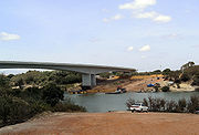
Takutu River Bridge
The Takutu River Bridge is a bridge across the Takutu River, linking Lethem in Guyana to Bonfim in Brazil. It was completed in 2009 and opened on 31 July 2009. Its official inauguration was on 14 September 2009, in the presence of leaders of both countries. It cost USD 5 million and was paid for...
to link Guyana and Brazil in the southwest of Guyana near Lethem. The bridge was officially opened on September 14, 2009, enabling economic interests in northern Brazil to link by road to the port at Georgetown. Unprecedented construction and population growth in Lethem since the bridge's opening reflects the significantly increased traffic and movement of goods facilitated by the bridge. The Takutu Bridge is seen as the first of several joint projects between Guyana and Brazil intended to facilitate cargo traffic: Brazil is expected to subsidize the paving of the Lethem-to-Georgetown road, a development that would have profound impacts on the area's economy and environment. Dredging of the Georgetown port to accommodate deeper-draft cargo vessels is also being planned.
Rail transport
Commercial railwayRail transport
Rail transport is a means of conveyance of passengers and goods by way of wheeled vehicles running on rail tracks. In contrast to road transport, where vehicles merely run on a prepared surface, rail vehicles are also directionally guided by the tracks they run on...
services for both passengers and cargo were operated until 1974. Two lines operated - the Demerara-Essequibo Railway, from Vreed en Hoop to Parika (18.5 miles (29.8 km)) and the Demerara-Berbice Railway
Demerara-Berbice Railway
The Railways of Guyana comprised two public railways and several industrial railways, including the first in South America.-Demerara-Berbice railway:...
, from Georgetown to Rosignol (65 miles (104.6 km)). With the upgrading of the West Coast Demerara/East Bank Essequibo and the East Coast Demerara/West Coast Berbice roadways, the Government decided in mid 1970s to cease operating the railway services, which were being run at a loss. In the Matthew's Ridge
Matthew's Ridge
Matthew's Ridge is a small town within the Barima-Waini administrative region of Guyana. It is located at .-History:During the 1960s, Matthews Ridge was being considered as a potential area in which to relocate the capital city of Guyana...
area, there is a 32 miles (51.5 km) railway service.
A railway service was once operated in Linden for the movement of bauxite ore. However trucks are now used to transport the bauxite ore.
Fluvial transport
It is generally agreed that, for the movement of bulky low-value goods over great distances, water transport is cheapest. This is especially true in Guyana, where the road infrastructure is poorly advanced. Moreover, with the widespread decentralization of economic activity that is being proposed by the government, and with the corresponding development of the interior regions of the country, the demand for water transport might, perhaps paradoxically, increase rather than diminish.The infrastructure that supports water transport in Guyana is located along the banks of the navigable rivers, namely, the Essequibo River, Demerara River and Berbice River. In addition to the wharves and stellings that provide coastal and inland linkages, there are facilities that handle both the country's overseas and local shipping requirements.
Virtually all exports and imports are transported by sea. The main port of Georgetown, located at the mouth of the Demerara River, comprises several wharves, most of which are privately owned. In addition, three berths are available for oceangoing vessels at Linden.
Draught constraints limit the size of vessels using Georgetown's harbour to . However, recent improvements in the channel in the Berbice River have made it possible for ships of up to to dock there.
Guyana's foreign trade is handled by foreign shipping companies. The largest bulk exports are bauxite
Bauxite
Bauxite is an aluminium ore and is the main source of aluminium. This form of rock consists mostly of the minerals gibbsite Al3, boehmite γ-AlO, and diaspore α-AlO, in a mixture with the two iron oxides goethite and hematite, the clay mineral kaolinite, and small amounts of anatase TiO2...
and sugar, and the largest volume imports are petroleum and wheat flour. Other important break-bulk exports include rice and timber.
Containers are used but because they are not part of the internal transport system, they are loaded and unloaded at the ports.
Internal barge transport is important for bauxite, sugar, rice and aggregates. In the case of sugar, for example, 98 percent of exports is delivered by barge to the port of Georgetown for export. Rivers are used for moving logs and account also for a significant share of those persons who travel to the interior.
It is estimated that about 1,000 kilometers of waterways in Guyana are utilized for commerce in Guyana. In addition, drainage canals are important transport channels for collecting sugar on the estates and for personal travel.
Ferries
Only two ferry services consistently show profits: the Rosignol-New Amsterdam and the Parika-Adventure. For the remainder, in particular for the Berbice River and the North West services, the Government provides a cross-subsidy funded out of the profits that are always realized by the Harbor Branch of the Transport and Harbors Department. Nevertheless, ferry operations have the potential to be profitable, provided that capital investments are made to improve their physical assets. With the establishment of a Maritime Administration and subsequently a National Sea Ports Authority the ferry operations may be privatized or operated as a commercially viable autonomous agency.
There is also a ferry linking Guyana and Suriname crossing the Corentyne River from Springlands (at Corriverton in Guyana) to Nieuw Nickerie, a town in Suriname.
Ultimately, key ferry links will be replaced with bridges, starting with one from Rosignol to New Amsterdam across the Berbice River.
At the end of 1999 the fleet of ferry vessels owned by the Transport and Harbors Department comprised nine motor vessels, six of which ranged in age from 15 to 55 years. Indeed, two of the vessels were over fifty years of age, and three over 30 years, with an average age of thirty-five. They are in almost continuous need of repair.
Air transportationAviationAviation is the design, development, production, operation, and use of aircraft, especially heavier-than-air aircraft. Aviation is derived from avis, the Latin word for bird.-History:...
Air transportation for business and pleasure is readily available for traveling to many parts of the hinterland. Several local airlines depart from both Ogle AirportOgle Airport
Ogle Airport is located on the Atlantic Ocean coast of Guyana, 6 miles east of the capital, Georgetown.In 2003 the airport was a local hub shuttling some 50,000 passengers and 1,800 tons of cargo annually. Construction began that year to expand the facility to an international airport with...
on the East Coast Demerara, 6 miles (9.7 km) south-east of Georgetown and from Cheddi Jagan International Airport
Cheddi Jagan International Airport
Cheddi Jagan International Airport , formerly Timehri International Airport, is the national airport of Guyana. The airport is located on the right bank of the Demerara River in the city of Timehri, south of Guyana's capital, Georgetown.-History:...
, at Timehri
Timehri
Timehri is a town in Guyana located 41 kilometers to the south of the nation's capital Georgetown. The name "Timehri" is an Amerindian word meaning "paintings and drawings on the rock"...
, 25 miles (40.2 km) south-west of Georgetown.
Air transport plays a vital role in the development of Guyana. Within the country, it provides a link between the coastal areas and communities in the hinterland, many of which are inaccessible by any other means of transportation. Thus, the economic and social well being of these areas and their integration into the fabric of the nation are critically dependent on the availability of air transport. Externally, passengers are moved to and from the country almost entirely by air. In addition, the potential of this mode of transport for the carriage of cargo, especially exports, continues to increase.
The first airplane flight took place in Guyana in March 1913 when George Schmidt, a German, flew a machine over Georgetown, taking off from the Bel Air Park Race Course.
In September 1929, the first airmail service to Guyana began.
The famous American flier, Colonel Charles Lindbergh
Charles Lindbergh
Charles Augustus Lindbergh was an American aviator, author, inventor, explorer, and social activist.Lindbergh, a 25-year-old U.S...
, arrived in the Demerara River with his flying boat (an amphibian craft) on September 22, 1929. The first regular flights to the interior started in 1939.
Although air transport in Guyana had its beginnings in the 1920s when the first "bush" services were introduced, Government's earnest participation can be dated from 1947 when a Director of Civil Aviation was appointed to regulate the industry. Regular shipments of beef from the Rupununi to Georgetown by air began on 9 July 1948. Amphibian aircraft have been vital to the development of the country as they are able land both on airstrips and on water.
The development of air transport in Guyana owes much to Arthur "Art" James Williams
Arthur James Williams
Lt. Col. Arthur "Art" James Williams, USAAF, AAM, OBE was a pioneering pilot who helped develop aviation in Guyana, then British Guiana.Art Williams arrived in British Guiana in August 1934 piloting an Ireland amphibian biplane, NC183M, powered by a Pratt & Whitney "Wasp", 9-cylinder 450 HP radial...
, a pilot and mechanic from the United States. He arrived in British Guiana in August 1934, and returned to the United States in October 1955. Over this period, except for the war years
World War II
World War II, or the Second World War , was a global conflict lasting from 1939 to 1945, involving most of the world's nations—including all of the great powers—eventually forming two opposing military alliances: the Allies and the Axis...
, during which he served with the United States Air Force, he developed British Guiana Airways Ltd. (registered 27 May, 1938) and operating regular internal services since 1939.
On 15 July 1955, the Government purchased British Guiana Airways. However, external services continued to be supplied almost exclusively by foreign airlines until Guyana Airways Corporation commenced regional air services in 1979. Subsequently, restrictions on the repatriation of profits in foreign exchange and other circumstances contributed to the withdrawal of services to Guyana by foreign airlines, with the exception of BWIA. Guyana Airways Corporation was therefore obliged to fill the breach by commencing jet operations to Miami, New York
New York
New York is a state in the Northeastern region of the United States. It is the nation's third most populous state. New York is bordered by New Jersey and Pennsylvania to the south, and by Connecticut, Massachusetts and Vermont to the east...
and Toronto
Toronto
Toronto is the provincial capital of Ontario and the largest city in Canada. It is located in Southern Ontario on the northwestern shore of Lake Ontario. A relatively modern city, Toronto's history dates back to the late-18th century, when its land was first purchased by the British monarchy from...
.
In the 1980s Guyana Airways Corporation's domestic operations started to deteriorate for a number of reasons, not least among them the unrealistically low fares it was required to charge and the lack of access to foreign exchange for imported aircraft parts and other requirements. The private sector therefore began to fill the gap and by 1991 three major domestic charter operators had emerged. In the meantime, Guyana Airways Corporation's domestic service continued to deteriorate and, by 1993, possessed only one Twin Otter DHC-6 to service the entire country. Under new management it was revitalized and saw a partial return to its original domestic role with the reintroduction of several domestic scheduled routes, because of the addition of two Shorts Skyvan SC7 aircraft, and a second Twin Otter DHC-6 aircraft.
In 2010, the International Civil Aviation Organization (ICAO) conferred "international" status to the air terminal at Ogle (IATA: OGL, ICAO: SYGO), a former sugarcane airstrip just a few miles south of Georgetown's center. In anticipation of increased regional air traffic to the facility, an EU-subsidized construction project began in January of that year, intended to upgrade the terminal building and extend the primary paved runway to a usable length of 4000 feet. Ogle is the hub for domestic flights to Guyana's interior and offers once-daily service to the in-town airstrip in Paramaribo, capital of neighboring Suriname.
Challenges and future development
The gross inadequacy of Guyana's transportation system militates against its social and economic development in several ways. First, it increases production costs and, therefore, reduces competitiveness, particularly in the mining and forestry sectors. Second, it inhibits the capacity to fully utilise those natural resources (gold, timber, diamonds, soils suitable for agriculture) that are not located on the coastland. Third, by severely limiting communication between those who live on the coast and those who inhabit the hinterland, it effectively divides the country into two almost unbridgeable cultures. Fourth, it acts as a barrier to the unity of the country in both a physical and spiritual sense: because they are not unified physically, Guyanese seem to find it difficult to think as Guyanese, to act as if they are one nation. Fifth, it restricts the coastal population's penetration of the interior, and forces coastlanders to live in a cramped and crowded manner on the coast, struggling and competing for land-space and other amenities, while more suitable areas are available farther south. And sixth, failure to occupy the greater part of the country, might tend to bolster some of the claims of Guyana's neighbours to its territory.According to Guyana's National Development Strategy, it is anticipated that by the year 2010 an inter-connected road system would have been established in Guyana. This network would have enabled easy access by road to the neighbouring countries of Brazil, Venezuela and Surinam; reduced the costs of utilising the country's timber and natural resources, thus making them more competitive in international markets; diversified agricultural development by making more easily available suitable areas in the hinterland, particularly in the Intermediate and Rupununi savannahs; relieved the over-crowded coastland of a significant proportion of its population, thus improving the quality of life of the inhabitants of both the coastal and interior areas; and made more feasible the equitable distribution of economic activity, not only in the agricultural but also in the manufacturing and small- industries sector.
In addition, there would have been constructed high-span bridges across the Demerara River at the same site as the Demerara Harbour Bridge, and the Berbice River upstream of Everton; a series of bridges and causeways linking the islands in the mouth of the Essequibo River to Morasi on the East Bank and Supenaam on the West Bank; and another high-span bridge across the Essequibo River at Monkey Jump.
Another new feature in 2010 would be the existence of deep water harbours at the mouths of the Essequibo and Demerara Rivers.
Moreover, the airstrip at Timehri Airport would have been extended, and the entire Airport refurbished to accommodate an increasing number of passengers. The airport at Ogle would have been privatised, and much improved and extended.
RailwaysRail transportRail transport is a means of conveyance of passengers and goods by way of wheeled vehicles running on rail tracks. In contrast to road transport, where vehicles merely run on a prepared surface, rail vehicles are also directionally guided by the tracks they run on...
total:187 km (all dedicated to ore transport)
standard gauge
Standard gauge
The standard gauge is a widely-used track gauge . Approximately 60% of the world's existing railway lines are built to this gauge...
:
139 km gauge
narrow gauge:
48 km gauge
Railway links with adjacent countries
Venezuela - no Brazil - no SurinameTransport in Suriname
The South American country of Suriname has a number of forms of transport.-Railways:*Railways, total: 166 km single track.**standard gauge: 80 km gauge in West-Suriname, but not in use...
- no
HighwayHighwayA highway is any public road. In American English, the term is common and almost always designates major roads. In British English, the term designates any road open to the public. Any interconnected set of highways can be variously referred to as a "highway system", a "highway network", or a...
s
total:7,970 km
paved:
590 km
unpaved:
7,380 km (1996 est.)
- Driving is on the left, a practice inherited from United KingdomUnited KingdomThe United Kingdom of Great Britain and Northern IrelandIn the United Kingdom and Dependencies, other languages have been officially recognised as legitimate autochthonous languages under the European Charter for Regional or Minority Languages...
colonial authorities. GuyanaGuyanaGuyana , officially the Co-operative Republic of Guyana, previously the colony of British Guiana, is a sovereign state on the northern coast of South America that is culturally part of the Anglophone Caribbean. Guyana was a former colony of the Dutch and of the British...
& SurinameSurinameSuriname , officially the Republic of Suriname , is a country in northern South America. It borders French Guiana to the east, Guyana to the west, Brazil to the south, and on the north by the Atlantic Ocean. Suriname was a former colony of the British and of the Dutch, and was previously known as...
are the only 2 countries on the (in-land) American continent who still drive on the left.
WaterwayWaterwayA waterway is any navigable body of water. Waterways can include rivers, lakes, seas, oceans, and canals. In order for a waterway to be navigable, it must meet several criteria:...
s
5,900 km total of navigable waterways; Berbice River, Demerara River, and Essequibo River are navigable by oceangoing vessels for 150 km, 100 km, and 80 km, respectivelyMerchant marine
total:1 ship ( or over) totaling /
ships by type: (1999 est.)
- cargo shipCargo shipA cargo ship or freighter is any sort of ship or vessel that carries cargo, goods, and materials from one port to another. Thousands of cargo carriers ply the world's seas and oceans each year; they handle the bulk of international trade...
1
Airports
51 (1999 est.)International Airport: Cheddi Jagan International Airport
Airports - with paved runways:
total:
9
1,524 to 2,437 m:
2
914 to 1,523 m:
1
under 914 m:
2 (1999 est.)
Airports - with unpaved runways:
total:
84
1,524 to 2,437 m:
2
914 to 1,523 m:
7
under 914 m:
37 (1999 est.)