

List of traffic circles in New Jersey
Encyclopedia
U.S. state
A U.S. state is any one of the 50 federated states of the United States of America that share sovereignty with the federal government. Because of this shared sovereignty, an American is a citizen both of the federal entity and of his or her state of domicile. Four states use the official title of...
of New Jersey
New Jersey
New Jersey is a state in the Northeastern and Middle Atlantic regions of the United States. , its population was 8,791,894. It is bordered on the north and east by the state of New York, on the southeast and south by the Atlantic Ocean, on the west by Pennsylvania and on the southwest by Delaware...
at one point had a total of 101 traffic circle
Traffic circle
A traffic circle or rotary is a type of circular intersection in which traffic must travel in one direction around a central island. In some countries, traffic entering the circle has the right-of-way and drivers in the circle must yield. In many other countries, traffic entering the circle must...
s, 44 of which were part of state roads
State highway
State highway, state road or state route can refer to one of three related concepts, two of them related to a state or provincial government in a country that is divided into states or provinces :#A...
. However, the number has shrunk as traffic circles have been phased out by the New Jersey Department of Transportation
New Jersey Department of Transportation
The New Jersey Department of Transportation is the agency responsible for transportation issues and policy in New Jersey. It is headed by the Commissioner of Transportation...
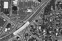
. In the 1920s and 1930s, New Jersey felt that traffic circles were an efficient way for moving traffic through three or more intersecting roads. Built in 1925, the first traffic circle in New Jersey was the Airport Circle
Airport Circle (Pennsauken)
The Airport Circle is a traffic circle in Pennsauken Township, New Jersey, United States. It is located at the intersection of Route 38, U.S. Route 30, and U.S. Route 130, close to the Camden border. South of the circle, Route 30 and Route 130 run concurrent until they reach the former Collingswood...
in Pennsauken
Pennsauken Township, New Jersey
Pennsauken Township is a township in Camden County, New Jersey, USA, and a suburb of Philadelphia. As of the 2010 census, the township population was 35,885....
. Many of these interchanges are rotaries in design, as opposed to the more successful modern roundabout
Roundabout
A roundabout is the name for a road junction in which traffic moves in one direction around a central island. The word dates from the early 20th century. Roundabouts are common in many countries around the world...
.
As suburban and rural populations grew New Jersey's traffic circles became outdated. The increased number of drivers on the roads resulted in traffic circles being more likely to hinder traffic than help it. Increased number of vehicles and faster traffic speeds made traffic circles more dangerous and accidents common. Many traffic circles became notorious for having frequent accidents and being confusing, especially for non-locals. The confusion frequently is the result of ignorance of the elementary traffic law which governs right of way while using traffic circles, NJSA 39:4-90, "The driver of a vehicle approaching an intersection shall yield the right of way to a vehicle which has entered the intersection. When 2 vehicles enter an intersection at the same time the driver of the vehicle on the left shall yield the right of way to the driver of the vehicle on the right.". Since a circle is comprised as a series of uncontrolled intersections, the driver to the right (entering the circle) has the right of way. Starting around the 1970s, the New Jersey Department of Transportation began phasing out traffic circles. Common methods of eliminating traffic circles are building a road through the circle, adding traffic light
Traffic light
Traffic lights, which may also be known as stoplights, traffic lamps, traffic signals, signal lights, robots or semaphore, are signalling devices positioned at road intersections, pedestrian crossings and other locations to control competing flows of traffic...
s, and the use of grade separation
Grade separation
Grade separation is the method of aligning a junction of two or more transport axes at different heights so that they will not disrupt the traffic flow on other transit routes when they cross each other. The composition of such transport axes does not have to be uniform; it can consist of a...
.
Traffic circles
Modified traffic circles are intersections where parts or all of the original circle still exist as a major part of the intersection.| Name | Image | Location | Status | Intersecting roads | Notes |
|---|---|---|---|---|---|
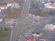
| Airport Circle | Newark Newark, New Jersey Newark is the largest city in the American state of New Jersey, and the seat of Essex County. As of the 2010 United States Census, Newark had a population of 277,140, maintaining its status as the largest municipality in New Jersey. It is the 68th largest city in the U.S... |
Defunct | |||
| Airport Circle Airport Circle (Pennsauken) The Airport Circle is a traffic circle in Pennsauken Township, New Jersey, United States. It is located at the intersection of Route 38, U.S. Route 30, and U.S. Route 130, close to the Camden border. South of the circle, Route 30 and Route 130 run concurrent until they reach the former Collingswood... |
Pennsauken Pennsauken Township, New Jersey Pennsauken Township is a township in Camden County, New Jersey, USA, and a suburb of Philadelphia. As of the 2010 census, the township population was 35,885.... 39.9337°N 75.0823°W |
Modified | US 30 U.S. Route 30 in New Jersey U.S. Route 30 is a U.S. highway running from Astoria, Oregon east to Atlantic City, New Jersey. In the U.S. state of New Jersey, US 30 runs from the Benjamin Franklin Bridge at the Delaware River in Camden, Camden County while concurrent with Interstate 676 southeast to Virginia... , US 130 U.S. Route 130 U.S. Route 130 is a north–south U.S. Highway completely within the state of New Jersey. It runs from Interstate 295 and US 40 at Deepwater in Pennsville Township, Salem County, where the road continues east as Route 49, north to US 1 in North Brunswick Township, Middlesex County, where... , NJ 70, NJ 38, Kaighn Ave. |
First traffic circle in New Jersey. Traffic lights, ramps and overpasses have been added. | |
| Airport Circle | Egg Harbor Township Egg Harbor Township, New Jersey Egg Harbor Township is a township in Atlantic County, New Jersey, United States. As of the 2010 census, the township population was 43,323, a growth of more than 40% since the previous enumeration.... 39.4318°N 74.5791°W |
Modified | CR 563 County Route 563 (New Jersey) County Route 563, abbreviated CR 563, is a county highway in the U.S. state of New Jersey. The highway extends from CR 629/Ocean Drive in Margate City, Atlantic County north to Route 72 in Woodland Township, Burlington County... , CR 646, Amelia Earhart Blvd. |
Entrance to the Atlantic City International Airport Atlantic City International Airport Atlantic City International Airport is a joint civil-military public airport located nine nautical miles northwest of the central business district of Atlantic City, in Atlantic County, New Jersey... . In 2011, the circle was revised to allow Delilah Road motorists to pass straight through the circle, plus the addition of traffic signals. |
|
| Allwood Circle | Clifton Clifton, New Jersey Clifton is a city in Passaic County, New Jersey, United States. As of the 2010 United States Census, the city had a total population of 84,136. The 2010 population represented an increase of 5,464 residents from its population of 78,672 in the 2000 Census, making it the state's 11th largest... 40.843°N 74.1596°W |
Modified | Allwood Road (CR 602), Bloomfield Avenue (CR 622) | ||
| Allenwood Circle (Hurleys Corner Circle) |  |
Allenwood Wall Township, New Jersey Wall Township is a township in Monmouth County, New Jersey, United States. As of the 2010 United States Census, the township population was 26,164.Wall Township was formally incorporated as a township by an act of the New Jersey Legislature on March 7, 1851... 40.1501°N 74.0960°W |
NJ 34 & Allaire Road | ||
| Asbury Park Circle | Asbury Park Asbury Park, New Jersey Asbury Park is a city in Monmouth County, New Jersey, United States, located on the Jersey Shore and part of the New York City Metropolitan Area. As of the 2010 United States Census, the city population was 16,116. The city is known for its rich musical history, including its association with... 40.2261°N 74.0377°W |
NJ 35, NJ 66, CR 16 | |||
| Barrington Circle | Barrington Barrington, New Jersey Barrington is a Borough in Camden County, New Jersey, United States. As of the 2010 United States Census, the borough population was 6,983.Barrington was incorporated as a borough on March 27, 1917, from portions of the now-defunct Centre Township, based on the results of a referendum held on April... |
Modified | |||
| Bayway Circle | Elizabeth Elizabeth, New Jersey Elizabeth is a city in Union County, New Jersey, United States. As of the 2010 United States Census, the city had a total population of 124,969, retaining its ranking as New Jersey's fourth largest city with an increase of 4,401 residents from its 2000 Census population of 120,568... 40.6507°N 74.2211°W |
Modified | US 1/9 U.S. Route 1/9 U.S. Route 9 is a U.S. highway in the northeast United States, running from Laurel, Delaware north to the Canadian border near Champlain, New York... , New Jersey Route 439 |
||
| Berlin Circle Berlin Circle (traffic circle) The Berlin Circle was a traffic circle in Berlin Township, New Jersey, United States located at the intersection of Route 73, Berlin-Cross Keys Road and Walker Avenue, and which also received traffic from nearby U.S. Route 30, and County Route 561. The New Jersey Department of Transportation ... |
Berlin Township Berlin Township, New Jersey Berlin Township is a Township in Camden County, New Jersey, United States. As of the 2010 United States Census, the township population was 5,357.Berlin was incorporated as a township on April 11, 1910, from portions of Waterford Township... 39.8016°N 74.9316°W |
Defunct | NJ 73, Berlin-Cross Keys Rd., Walker Ave. | ||
| Boulevard and Passaic Avenue Circle | Hasbrouck Heights Hasbrouck Heights, New Jersey Hasbrouck Heights is a borough in Bergen County, New Jersey, United States. As of the 2010 census, the borough population was 11,842. An inner-ring suburb of New York City, Hasbrouck Heights is located approximately northwest of Midtown Manhattan and west of Upper Manhattan.Hasbrouck Heights was... , Wood-Ridge Wood-Ridge, New Jersey Wood-Ridge is a borough in Bergen County, New Jersey, United States. As of the 2010 United States Census, the borough population was 7,626.Wood-Ridge was incorporated as a borough by an Act of the New Jersey Legislature on December 6, 1894, from portions of Bergen Township, based on the results of... |
||||
| Bound Brook Circle | Bound Brook Bound Brook, New Jersey Bound Brook is a borough in Somerset County, New Jersey, United States. At the United States 2010 Census, the population was 10,402.Bound Brook was originally incorporated as a town by an Act of the New Jersey Legislature on March 24, 1869, within portions of Bridgewater Township... 40.5615°N 74.5278°W |
East Main St and Bolmer Blvd. | |||
| Brielle Circle Brielle Circle The Brielle Circle was a traffic circle in Wall Township, New Jersey, United States, located where Route 34, Route 35, and Route 70 meet. It was the southern end for the never-built Route 18 extension. In 2001 the circle was replaced by an at-grade intersection with jughandles.... |
Wall Township Wall Township, New Jersey Wall Township is a township in Monmouth County, New Jersey, United States. As of the 2010 United States Census, the township population was 26,164.Wall Township was formally incorporated as a township by an act of the New Jersey Legislature on March 7, 1851... 40.1162°N 74.0729°W |
Defunct | NJ 34, NJ 35, NJ 70 | Replaced with an at-grade intersection At-grade intersection An at-grade intersection is a junction at which two or more transport axes cross at the same level .-Traffic management:With areas of high or fast traffic, an at-grade intersection normally requires a traffic control device such as a stop sign, traffic light or railway signal to manage conflicting... with jughandle Jughandle A jughandle is a type of ramp or slip road that changes the way traffic turns left at at-grade intersections. Instead of a standard left turn being made from the left lane, left-turning traffic uses a ramp on the right side of the road... s. |
|
| Brookdale Circle | Lincroft Lincroft, New Jersey Lincroft is a part of Middletown Township, in Monmouth County, New Jersey. As of the 2010 United States Census, the Lincroft census-designated place had a population was 6,135.-Geography:Lincroft is located at .... 40.3321°N 74.1317°W |
CR 520 County Route 520 (New Jersey) County Route 520 is a county highway in the U.S. state of New Jersey. County Route 520 is a major road across Monmouth County connecting the county's central towns to the Jersey Shore at Sea Bright.-Route description:... , Campus Drive |
Added in 2007; previously an at-grade intersection with a traffic light. Located at the entrance to Brookdale Community College Brookdale Community College Brookdale Community College is an accredited coeducational public community college in Lincroft, Monmouth County, New Jersey. Brookdale Community College was founded in 1967 and has Higher Education Centers in Neptune, Freehold, Hazlet, Long Branch, Sandy Hook, and Wall.Brookdale is an... . |
||
| Brooklawn Circle | Brooklawn Brooklawn, New Jersey Brooklawn is a Borough in Camden County, New Jersey, United States. As of the 2010 United States Census, the borough population was 1,955.Brooklawn was incorporated as a borough on March 11, 1924, from portions of the now-defunct Centre Township, based on the results of a referendum held on April... |
||||
| Browning Road Circle | Pennsauken Pennsauken Township, New Jersey Pennsauken Township is a township in Camden County, New Jersey, USA, and a suburb of Philadelphia. As of the 2010 census, the township population was 35,885.... |
Defunct | |||
| Brunswick Circle | Trenton Trenton, New Jersey Trenton is the capital of the U.S. state of New Jersey and the county seat of Mercer County. As of the 2010 United States Census, Trenton had a population of 84,913... 40.2453°N 74.7428°W |
US 206 U.S. Route 206 U.S. Route 206 is a long north–south United States highway in New Jersey and Pennsylvania, United States. Only about a half a mile of its length is in Pennsylvania; the Milford-Montague Toll Bridge carries it over the Delaware River into New Jersey, where it is the remainder of the route... , US 1 Bus. U.S. Route 1 Business (Trenton, New Jersey) U.S. Route 1 Business is a four-lane surface road that provides an alternate to the Trenton Freeway northeast of Trenton in Mercer County, New Jersey. The route is long and runs between US 1 in Trenton and Lawrence Township. On the border of Trenton and Lawrence Township, US 1 Business... , CR 645 Calhoun Street Extension The Calhoun Street Extension is a series of roads in Trenton, New Jersey and nearby Lawrence Township. It runs from the Calhoun Street Bridge over the Delaware River to Brunswick Circle, and is composed of the following named streets:*Calhoun Street... |
|||
| Burnet Street Circle | New Brunswick New Brunswick, New Jersey New Brunswick is a city in Middlesex County, New Jersey, USA. It is the county seat and the home of Rutgers University. The city is located on the Northeast Corridor rail line, southwest of Manhattan, on the southern bank of the Raritan River. At the 2010 United States Census, the population of... |
Defunct | |||
| Camp Merritt Memorial Circle Camp Merritt Memorial Circle The Camp Merritt Memorial Circle is a traffic circle in Cresskill and Dumont, New Jersey at the intersection of Madison Avenue and Knickerbocker Road .... |
Cresskill Cresskill, New Jersey Cresskill is a borough in Bergen County, New Jersey, United States. As of the 2010 United States Census, the borough population was 8,573. The town got its name from the watercress that grew in its streams, or "kills".... 40.9413°N 73.9768°W |
CR 505 County Route 505 (New Jersey) County Route 505 is a county highway in the U.S. state of New Jersey. The highway extends 20.64 miles from John F. Kennedy Boulevard in Union City to the New York state line in Northvale.-Route description:... , Madison Ave. |
|||
| Cardiff Circle | Egg Harbor Egg Harbor Township, New Jersey Egg Harbor Township is a township in Atlantic County, New Jersey, United States. As of the 2010 census, the township population was 43,323, a growth of more than 40% since the previous enumeration.... 39.4073°N 74.5637°W |
Defunct | US 40 U.S. Route 40 in New Jersey U.S. Route 40 is a U.S. highway running from Park City, Utah east to Atlantic City, New Jersey. The easternmost segment of the route runs through the southern part of New Jersey between the Delaware Memorial Bridge over the Delaware River in Pennsville Township, Salem County, where it continues... , US 322 U.S. Route 322 in New Jersey U.S. Route 322 is a U.S. highway running from Cleveland, Ohio east to Atlantic City, New Jersey. The easternmost segment of the route in New Jersey runs from the Commodore Barry Bridge over the Delaware River in Logan Township, Glocuester County, where it continues into Chester, Pennsylvania,... , CR 563 County Route 563 (New Jersey) County Route 563, abbreviated CR 563, is a county highway in the U.S. state of New Jersey. The highway extends from CR 629/Ocean Drive in Margate City, Atlantic County north to Route 72 in Woodland Township, Burlington County... |
||
| Charlotte Circle | Jersey City Jersey City, New Jersey Jersey City is the seat of Hudson County, New Jersey, United States.Part of the New York metropolitan area, Jersey City lies between the Hudson River and Upper New York Bay across from Lower Manhattan and the Hackensack River and Newark Bay... |
Defunct | |||
| Clark Circle Clark Circle The Clark Circle is a traffic circle located in the town of Clark, New Jersey. It currently connects Central Avenue, Brant Avenue, Valley Road, and the Garden State Parkway via Exit 135. As of September 2007, plans are underway to reconstruct the traffic circle with signals. This job ended in... |
Clark Clark, New Jersey Clark is a township in southern Union County, New Jersey, United States. As of the 2010 United States Census, the township population was 14,756.-History:... 40.6269°N 74.3044°W |
Modified | G.S. Pkwy. Garden State Parkway The Garden State Parkway is a 172.4-mile limited-access toll parkway that stretches the length of New Jersey from the New York line at Montvale, New Jersey, to Cape May at New Jersey's southernmost tip. Its name refers to New Jersey's nickname, the "Garden State." Most New Jersey residents refer... , CR 613, CR 632 |
Exit 135 of the Garden State Pkwy., traffic lights added in 2007. | |
| Collingswood Circle Collingswood Circle The Collingswood Circle was a rotary in Collingswood, New Jersey, United States. It was located at the intersection of U.S. Route 130, U.S. Route 30, and Woodlynne Avenue. North of the former circle, U.S. Route 30 and U.S. Route 130 run concurrent until they reach the Airport Circle in Pennsauken.... |
Collingswood Collingswood, New Jersey Collingswood is a borough in Camden County, New Jersey, United States. As of the 2010 United States Census, the borough population was 13,926.... 39.9189°N 75.0888°W |
Defunct | US 30 U.S. Route 30 in New Jersey U.S. Route 30 is a U.S. highway running from Astoria, Oregon east to Atlantic City, New Jersey. In the U.S. state of New Jersey, US 30 runs from the Benjamin Franklin Bridge at the Delaware River in Camden, Camden County while concurrent with Interstate 676 southeast to Virginia... , US 130 U.S. Route 130 U.S. Route 130 is a north–south U.S. Highway completely within the state of New Jersey. It runs from Interstate 295 and US 40 at Deepwater in Pennsville Township, Salem County, where the road continues east as Route 49, north to US 1 in North Brunswick Township, Middlesex County, where... , White Horse Pike, Woodlynne Ave. |
Replaced by an at-grade intersection with jughandles in 2009. | |
| Collingwood Circle Collingwood Circle The Collingwood Circle is a traffic circle in New Jersey. Route 33 and Route 34 split around this circle in Wall Township, New Jersey. CR 547 also intersects the circle.... |
Wall Township Wall Township, New Jersey Wall Township is a township in Monmouth County, New Jersey, United States. As of the 2010 United States Census, the township population was 26,164.Wall Township was formally incorporated as a township by an act of the New Jersey Legislature on March 7, 1851... 40.2192°N 74.1284°W |
NJ 33, NJ 34, CR 547 County Route 547 (New Jersey) County Route 547, abbreviated CR 547, is a county highway in the U.S. state of New Jersey. The highway extends from Route 70 in Lakehurst to Broad Street in Eatontown... |
|||
| Cooper Landing Circle | Cherry Hill Cherry Hill, New Jersey Cherry Hill is a township in Camden County, New Jersey, in the United States. As of the 2010 United States Census, the township had a population of 71,045, representing an increase of 1,080 from the 69,965 residents enumerated during the 2000 Census... 39.9405°N 75.0098°W |
Modified | NJ 38, Cooper Landing Road, Church Road | ||
| Cranbury-Hightstown Circle | Cranbury Cranbury Township, New Jersey - Demographics :As of the census of 2000, there were 3,227 people, 1,091 households, and 877 families residing in the township. The population density was 240.6 people per square mile . There were 1,121 housing units at an average density of 83.6 per square mile... 40.2919°N 74.5205°W |
US 130 U.S. Route 130 U.S. Route 130 is a north–south U.S. Highway completely within the state of New Jersey. It runs from Interstate 295 and US 40 at Deepwater in Pennsville Township, Salem County, where the road continues east as Route 49, north to US 1 in North Brunswick Township, Middlesex County, where... , CR 539 County Route 539 (New Jersey) County Route 539, abbreviated CR 539, is a county highway in the U.S. state of New Jersey. The highway extends from Main Street in Tuckerton to U.S. Route 130 in Cranbury Township. However, signage on CR 539 suggests that it crosses U.S... , CR 685 |
|||
| Eatontown Circle Eatontown Circle The Eatontown Circle was a traffic circle in Eatontown, New Jersey, located at the intersection of Route 35, Route 36, Wall Street, and near Wyckoff Road CR 547, near the Monmouth Mall. At the time of its construction, the southwest quadrant was built on a farm owned by the Valentino Family from... |
Eatontown Eatontown, New Jersey Eatontown is a borough in Monmouth County, New Jersey, United States. As of the 2010 census, the borough population was 12,709.What is now Eatontown was originally incorporated as Eatontown Township by an Act of the New Jersey Legislature on April 4, 1873, from portions of Ocean Township and... 40.2909°N 74.0518°W |
Defunct | NJ 35, NJ 36 | ||
| Ellisburg Circle Ellisburg Circle The Ellisburg Circle was a traffic circle that stood in Cherry Hill Township, New Jersey from 1938 to 1992, at the intersection between Route 41, Route 70 and Route 154. The name is used as a shopping center at the location of the former circle.... |
Cherry Hill Cherry Hill, New Jersey Cherry Hill is a township in Camden County, New Jersey, in the United States. As of the 2010 United States Census, the township had a population of 71,045, representing an increase of 1,080 from the 69,965 residents enumerated during the 2000 Census... 39.9138°N 75.0102°W |
Defunct | NJ 41, NJ 70, NJ 154 | ||
| Flemington Circle | 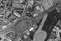 |
Flemington Flemington, New Jersey Flemington is a borough in Hunterdon County, New Jersey, United States. As of the United States 2010 Census, the borough population was 4,581. It is the county seat of Hunterdon County.... 40.5026°N 74.8534°W |
US 202 U.S. Route 202 in New Jersey U.S. Route 202 is a U.S. Highway running from New Castle, Delaware northeast to Bangor, Maine. In the U.S. state of New Jersey, the route runs from the New Hope-Lambertville Toll Bridge over the Delaware River at the Pennsylvania border in Delaware Township, Hunterdon County near Lambertville... , NJ 12, NJ 31 |
To be replaced with a modern roundabout Roundabout A roundabout is the name for a road junction in which traffic moves in one direction around a central island. The word dates from the early 20th century. Roundabouts are common in many countries around the world... . |
|
| Four Mile Circle Four Mile Circle Four Mile Circle is a traffic circle in the U.S. state of New Jersey. It is located at the junction of Route 70, Route 72, Buddtown Road , and New Lisbon Road . This junction is between Southampton, Pemberton, and Woodland Townships, located within the New Jersey Pine Barrens.-External links:*... |
Southampton Southampton Township, New Jersey Southampton Township is a Township in Burlington County, New Jersey, United States. As of the United States 2000 Census, the township population was 10,388.... , Pemberton Pemberton Township, New Jersey Pemberton Township is a township in Burlington County, New Jersey, United States. As of the 2000 United States Census, the township population was 28,691.... 39.8989°N 74.5963°W |
NJ 70, NJ 72, CR 644, CR 646 | |||
| Franklin Lake Circle | Franklin Lakes Franklin Lakes, New Jersey Franklin Lakes is a borough in Bergen County, New Jersey, United States. As of the 2010 census, the borough population was 10,590. As of the 2000 Census, Franklin Lakes had the 18th-highest per-capita income of all 566 municipalities in the state. Nationwide, Franklin Lakes ranked 17th among the... |
||||
| Freehold Circle | Freehold Freehold Borough, New Jersey Freehold is a borough in Monmouth County, New Jersey, United States. As of the 2010 United States Census, the borough population was 12,052. It is the county seat of Monmouth County.... 40.2592°N 74.2912°W |
Defunct | US 9, NJ 33 Bus., Manalapan Ave. | ||
| Ho-Ho-Kus Circle | Ho-Ho-Kus Ho-Ho-Kus, New Jersey Ho-Ho-Kus is a borough in Bergen County, New Jersey, United States. As of the 2010 census, the borough population was 4,078. It is the home of several historical landmarks, including the Ho-Ho-Kus Inn and The Hermitage.... |
Defunct | |||
| Lakehurst Circle | Lakehurst Lakehurst, New Jersey Lakehurst is a Borough in Ocean County, New Jersey, United States. As of the United States 2010 Census, the borough population was 2,654.Lakehurst was incorporated as a borough by an Act of the New Jersey Legislature on April 7, 1921, from portions of Manchester Township, based on the results of a... 40.0128°N 74.3052°W |
NJ 37, NJ 70 | |||
| Laurelton Circle | Brick Township Brick Township, New Jersey -Transportation:The major county routes that pass through are CR 528, and CR 549 . Two state routes pass through: Route 70 and Route 88... 40.0688°N 74.1303°W |
Defunct | NJ 70, NJ 88, CR 630 | ||
| Ledgewood Circle Ledgewood Circle The Ledgewood Circle was the intersection of New Jersey State Route 10 and U.S. Route 46 in the Ledgewood neighborhood of Roxbury Township, New Jersey. Both highways are major east–west arteries in Morris County, New Jersey, and both are also lined with businesses and strip malls. ... |
Ledgewood Ledgewood, New Jersey Ledgewood is an unincorporated area within Roxbury Township in Morris County, New Jersey, United States. The area is served as United States Postal Service ZIP Code 07852.... 40.8790°N 74.6508°W |
Defunct | US 46 U.S. Route 46 U.S. Route 46 is an east–west U.S. Highway, running for , completely within the state of New Jersey. The west end is at an interchange with Interstate 80 and Route 94 in Columbia, Warren County on the Delaware River... , NJ 10, Circle Dr. |
||
| Linden Circle | Linden Linden, New Jersey - Local government :, the Mayor of Linden is . The former longtime Mayor of Linden is 82-year-old John T. Gregorio, who served as mayor of Linden for 30, nonconsecutive years and was repeatedly tagged with scandal during his mayoral career, including one felony conviction, later pardoned, which... 40.6399°N 74.2879°W |
Defunct | CR 607, CR 615 | ||
| Little Ferry Circle Little Ferry Circle The Little Ferry Circle is a traffic circle connecting U.S. Route 46 and Bergen Turnpike in Little Ferry, New Jersey.The circle was originally constructed in 1933... |
Little Ferry Little Ferry, New Jersey Little Ferry is a borough in Bergen County, New Jersey, United States. As of the 2010 census, the borough population was 10,626.-Geography:Little Ferry is located at .... 40.8529°N 74.0340°W |
Modified | US 46 U.S. Route 46 U.S. Route 46 is an east–west U.S. Highway, running for , completely within the state of New Jersey. The west end is at an interchange with Interstate 80 and Route 94 in Columbia, Warren County on the Delaware River... , Bergen Tpke. |
||
| Livingston Circle | Livingston Livingston, New Jersey Livingston is a township in Essex County, New Jersey, United States. As of the United States 2000 Census, the township population was 29,366.Livingston was incorporated as a township by an Act of the New Jersey Legislature on February 5, 1813, from portions of Caldwell Township and Springfield... |
Modified | |||
| Main Street Circle | Flemington Flemington, New Jersey Flemington is a borough in Hunterdon County, New Jersey, United States. As of the United States 2010 Census, the borough population was 4,581. It is the county seat of Hunterdon County.... 40.5018°N 74.8586°W |
NJ 12, Main St., South Main St., Reaville Ave. | |||
| Manasquan Circle | Wall Township Wall Township, New Jersey Wall Township is a township in Monmouth County, New Jersey, United States. As of the 2010 United States Census, the township population was 26,164.Wall Township was formally incorporated as a township by an act of the New Jersey Legislature on March 7, 1851... 40.1323°N 74.0652°W |
NJ 35, CR 524 Spur | |||
| Marlton Circle Marlton Circle The Marlton Circle was a traffic circle in the Marlton section of Evesham Township, New Jersey, located at the intersection of Route 70 and Route 73... |
|
Evesham Township Evesham Township, New Jersey Evesham Township is a township in Burlington County, New Jersey, United States. The township population was 45,538 as of the 2010 United States Census.... 39.8938°N 74.9278°W |
Defunct | NJ 70, NJ 73 | Replaced with an interchange in 2011. |
| Medford Circle | Medford | Defunct | |||
| Morlot Avenue Bridge Circle | Paterson Paterson, New Jersey Paterson is a city serving as the county seat of Passaic County, New Jersey, United States. As of the 2010 United States Census, its population was 146,199, rendering it New Jersey's third largest city and one of the largest cities in the New York City Metropolitan Area, despite a decrease of 3,023... 40.9230°N 74.1413°W |
Defunct | NJ 20, CR 651 | ||
| Netcong Circle | Netcong Netcong, New Jersey Netcong is a Borough in Morris County, New Jersey, United States. As of the United States 2000 Census, the borough population was 2,580. Its estimated population in 2006 was 3,292... 40.8968°N 74.7003°W |
US 46 U.S. Route 46 U.S. Route 46 is an east–west U.S. Highway, running for , completely within the state of New Jersey. The west end is at an interchange with Interstate 80 and Route 94 in Columbia, Warren County on the Delaware River... , NJ 183 New Jersey Route 183 Route 183 is a long state highway in the northern regions of New Jersey. The southern end of NJ 183 is at an interchange with Interstate 80 and U.S. Route 206 near Netcong, while the northern end is at an interchange with US 206 in Stanhope. The route heads northward through downtown Netcong and... |
|||
| Park Avenue and Passaic Avenue | Rutherford Rutherford, New Jersey Rutherford is a borough in Bergen County, New Jersey, United States. As of the 2010 United States Census, the borough population was 18,061. It is an inner-ring suburb of New York City, located west of Midtown Manhattan.... 40.8263°N 74.1072°W |
Modified | |||
| Pennington Circle | Pennington Pennington, New Jersey Pennington is a Borough in Mercer County, New Jersey, United States. As of the 2010 United States Census, the borough population was 2,585.Pennington was established as a borough by an Act of the New Jersey Legislature on January 31, 1890, from portions of Hopewell Township, based on the results of... 40.3082°N 74.7866°W |
NJ 31, CR 546 County Route 546 (New Jersey) County Route 546, abbreviated CR 546, is a county highway in the U.S. state of New Jersey. The highway begins at the Washington Crossing Bridge at Titusville, New Jersey and extends from Route 29 in Hopewell Township to U.S... , CR 640 |
|||
| Penns Neck Circle Penns Neck Circle Penns Neck Circle is a traffic circle in West Windsor Township, New Jersey. It is located at the junction of U.S. 1 and Washington Road. It is a major intersection, as Washington Road is one of three connections between Route 1 and Princeton, New Jersey.... |
 |
West Windsor West Windsor Township, New Jersey -Demographics:As of Census 2010, West Windsor had a population of 27,165. The median age was 39.6. The racial and ethnic composition of the population was 54.9% White, 3.7% Black or African American, 0.1% Native American, 37.7% Asian, 1.0% some other race and 2.6% reporting two or more races... 40.3315°N 74.6380°W |
Modified | US 1 U.S. Route 1 in New Jersey U.S. Route 1 is a United States highway which parallels the East Coast of the United States, running from Key West, Florida in the south to Fort Kent, Maine at the Canadian border in the north. Of the entire length of the route, of it runs through New Jersey... , CR 571 County Route 571 (New Jersey) County Route 571, abbreviated CR 571, is a county highway in the U.S. state of New Jersey. The highway extends from Route 37 in Toms River Township to Route 27 in the Borough of Princeton.-Ocean County:... |
|
| Pole Tavern Circle Pole Tavern Circle Pole Tavern Circle is a traffic circle in Upper Pittsgrove Township, New Jersey, located at the intersection of U.S. Route 40, State Route 77, Monroeville Road , and Daretown Road .... |
Upper Pittsgrove Upper Pittsgrove Township, New Jersey Upper Pittsgrove Township is a Township in Salem County, New Jersey, United States. As of the 2000 United States Census, the township population was 3,468.Upper Pittsgrove Township was incorporated on March 10, 1846, from portions of Pittsgrove Township... 39.6170°N 75.2294°W |
US 40 U.S. Route 40 in New Jersey U.S. Route 40 is a U.S. highway running from Park City, Utah east to Atlantic City, New Jersey. The easternmost segment of the route runs through the southern part of New Jersey between the Delaware Memorial Bridge over the Delaware River in Pennsville Township, Salem County, where it continues... , NJ 77, CR 604, CR 635 |
|||
| Pudgy Circle | McGuire AFB McGuire Air Force Base JB MDL McGuire is a United States Air Force base located approximately south-southeast of Trenton, New Jersey. McGuire is under the jurisdiction of the USAF Air Mobility Command... |
McGuire Blvd, First Street | |||
| Race Track Circle Race Track Circle The Race Track Circle was a traffic circle in Cherry Hill Township, New Jersey, United States. It was located at the intersection of Route 70 and Haddonfield Road . It takes its name from the former Garden State Park race track, which was located by the circle. The circle has been replaced by an... |
Cherry Hill Cherry Hill, New Jersey Cherry Hill is a township in Camden County, New Jersey, in the United States. As of the 2010 United States Census, the township had a population of 71,045, representing an increase of 1,080 from the 69,965 residents enumerated during the 2000 Census... 39.9194°N 75.0343°W |
Defunct | NJ 70, CR 644 | ||
| Red Lion Circle | Southampton Southampton Township, New Jersey Southampton Township is a Township in Burlington County, New Jersey, United States. As of the United States 2000 Census, the township population was 10,388.... 39.8872°N 74.7411°W |
US 206 U.S. Route 206 U.S. Route 206 is a long north–south United States highway in New Jersey and Pennsylvania, United States. Only about a half a mile of its length is in Pennsylvania; the Milford-Montague Toll Bridge carries it over the Delaware River into New Jersey, where it is the remainder of the route... , NJ 70 |
|||
| Ridgefield Circle | Ridgefield Ridgefield, New Jersey There were 4,020 households out of which 32.1% had children under the age of 18 living with them, 59.7% were married couples living together, 9.9% had a female householder with no husband present, and 26.2% were non-families. 23.0% of all households were made up of individuals and 11.8% had someone... |
Defunct | |||
| Route 12 Circle | Flemington Flemington, New Jersey Flemington is a borough in Hunterdon County, New Jersey, United States. As of the United States 2010 Census, the borough population was 4,581. It is the county seat of Hunterdon County.... 40.5044°N 74.8712°W |
NJ 12, CR 523 County Route 523 (New Jersey) County Route 523 is a county highway in the U.S. state of New Jersey. The highway extends from Main Street in Stockton to Hillside Avenue in Bedminster Township.-Hunterdon County:... , Mine St. |
|||
| Routes 1 & 130 Circle | North Brunswick North Brunswick Township, New Jersey -Demographics:At the 2010 census, there were 40,742 people, 13,635 households and 9,367 families residing in the township. The population density was 3,018.3 per square mile . There were 13,932 housing units at an average density of 1,158.8 per square mile... 40.4627°N 74.4553°W |
Defunct | US 1 U.S. Route 1 in New Jersey U.S. Route 1 is a United States highway which parallels the East Coast of the United States, running from Key West, Florida in the south to Fort Kent, Maine at the Canadian border in the north. Of the entire length of the route, of it runs through New Jersey... , US 130 U.S. Route 130 U.S. Route 130 is a north–south U.S. Highway completely within the state of New Jersey. It runs from Interstate 295 and US 40 at Deepwater in Pennsville Township, Salem County, where the road continues east as Route 49, north to US 1 in North Brunswick Township, Middlesex County, where... , NJ 171 |
Replaced by at-grade intersection, now an interchange. | |
| Somers Point Circle | Somers Point Somers Point, New Jersey Somers Point is a city in Atlantic County, New Jersey, United States. At the 2010 United States Census, the city population was 10,795.The City of Somers Point is in the eastern part of Atlantic County, southwest of Atlantic City.-History:... 39.3087°N 74.5993°W |
Defunct | NJ 52 New Jersey Route 52 Route 52 is a state highway in the southern part of the U.S. state of New Jersey. The highway runs from Palen Avenue in Ocean City, Cape May County north to U.S. Route 9 in Somers Point, Atlantic County. It is composed mostly of a series of four-lane undivided bridges over Great Egg Harbor Bay... , CR 559 County Route 559 (New Jersey) County Route 559, abbreviated CR 559, is a county highway in the U.S. state of New Jersey also known as Weymouth Rd. The highway extends from the former Somers Point Circle at MacArthur Boulevard in Somers Point to Egg Harbor Road in Hammonton.-Route description:CR 559 begins at an intersection... , CR 585 County Route 585 (New Jersey) County Route 585, abbreviated CR 585, is a county highway in the U.S. state of New Jersey. The highway extends from MacArthur Boulevard in Somers Point to Absecon Boulevard in Absecon.- Route description :... |
Replaced by an intersection with traffic signals. | |
| Somerville Circle Somerville Circle The Somerville Circle is a traffic circle located on the border of Bridgewater Township and Raritan, New Jersey, United States. The circle is at the intersection of U.S. Routes 202 and 206, and New Jersey Route 28... |
 |
Bridgewater Bridgewater Township, New Jersey Bridgewater Township is a township in Somerset County, New Jersey, United States. , the township population was 44,464.Bridgewater Township was originally created by Royal Charter on April 4, 1749, from portions of the Northern precinct, and was incorporated as one of New Jersey's initial group of... , Raritan Raritan, New Jersey Raritan is a Borough in Somerset County, New Jersey, United States. As of the United States 2010 Census, the borough population was 6,881.-Geography:Raritan is located at .... 40.5757°N 74.6290°W |
Modified | US 202 U.S. Route 202 in New Jersey U.S. Route 202 is a U.S. Highway running from New Castle, Delaware northeast to Bangor, Maine. In the U.S. state of New Jersey, the route runs from the New Hope-Lambertville Toll Bridge over the Delaware River at the Pennsylvania border in Delaware Township, Hunterdon County near Lambertville... , US 206 U.S. Route 206 U.S. Route 206 is a long north–south United States highway in New Jersey and Pennsylvania, United States. Only about a half a mile of its length is in Pennsylvania; the Milford-Montague Toll Bridge carries it over the Delaware River into New Jersey, where it is the remainder of the route... , NJ 28 |
An overpass and traffic lights were added in the 1990s. |
| Station Square | Rutherford Rutherford, New Jersey Rutherford is a borough in Bergen County, New Jersey, United States. As of the 2010 United States Census, the borough population was 18,061. It is an inner-ring suburb of New York City, located west of Midtown Manhattan.... 40.8284°N 74.1011°W |
Modified | Park Avenue, Orient Way, Union Avenue, and Erie Avenue | Redesigned in 2005. | |
| Teaneck Circle | Teaneck Teaneck, New Jersey Teaneck is a township in Bergen County, New Jersey, and a suburb in the New York metropolitan area. As of the 2010 United States Census, the township population was 39,776, making it the second-most populous among the 70 municipalities in Bergen County.... |
Defunct | |||
| Tonnele Circle Tonnele Circle The Tonnele Circle is an intersection in Jersey City, New Jersey, United States. It is named after Tonnele Avenue, the north-south road that runs through it. Entrances and exits are, listed clockwise from north:*Tonnele Avenue north... |
 |
Jersey City Jersey City, New Jersey Jersey City is the seat of Hudson County, New Jersey, United States.Part of the New York metropolitan area, Jersey City lies between the Hudson River and Upper New York Bay across from Lower Manhattan and the Hackensack River and Newark Bay... 40.7394°N 74.0654°W |
Modified | US 1/9 U.S. Route 1/9 U.S. Route 9 is a U.S. highway in the northeast United States, running from Laurel, Delaware north to the Canadian border near Champlain, New York... , US 1/9 Truck, NJ 139, Tonnele Ave. |
|
| Union Avenue Circle | Lakehurst Lakehurst, New Jersey Lakehurst is a Borough in Ocean County, New Jersey, United States. As of the United States 2010 Census, the borough population was 2,654.Lakehurst was incorporated as a borough by an Act of the New Jersey Legislature on April 7, 1921, from portions of Manchester Township, based on the results of a... 40.0117°N 74.3259°W |
NJ 70, Union Ave., South Union Ave., Pine St., Myrtle Ave. | |||
| Victory Circle Victory Circle Victory Circle was a traffic circle where U.S. Route 9 and NJ 35 merged and split in South Amboy, New Jersey, United States. Victory Circle has been replaced by the Victory Interchange.... |
South Amboy South Amboy, New Jersey South Amboy is a city in Middlesex County, New Jersey, on the Raritan Bay. As of the 2000 United States Census, the city population was 7,913.South Amboy, and Perth Amboy across the Raritan River, are collectively referred to as The Amboys... 40.4962°N 74.2978°W |
Defunct | US 9, NJ 35, Chevalier Ave., Main St. | Replaced with a diamond interchange in 2006. | |
| Watchung Circle | Mountainside Mountainside, New Jersey If you are looking for the community in Ontario, see Mountainside, Ontario.Mountainside is a borough in Union County, New Jersey, United States... 40.6872°N 74.3639°W |
CR 645, CR 642 | |||
| Westfield Circle | Westfield Westfield, New Jersey Westfield is a town in Union County, New Jersey, United States. As of the 2010 United States Census, the town population was 30,316. The old village area, now the downtown district, was settled in 1720 as part of the Elizabethtown Tract.... 40.6485°N 74.3503°W |
CR 509 County Route 509 (New Jersey) County Route 509 is a county highway in the U.S. state of New Jersey. The highway extends 25.78 miles from North Avenue in Westfield to Straight Street in Paterson.... , CR 610, NJ 28, Westfield Ave., Watterson St. |
Expanded to two lanes in 2005 with one way designations added to Watterson St. (Inbound), and Westfield Ave. (Outbound) | ||
| White Horse Circle | White Horse White Horse, New Jersey White Horse is a census-designated place and unincorporated area located within Hamilton Township, in Mercer County, New Jersey. As of the United States 2000 Census, the CDP population was 9,373.-Geography:White Horse is located at .... 40.1882°N 74.7048°W |
Modified | US 206 U.S. Route 206 U.S. Route 206 is a long north–south United States highway in New Jersey and Pennsylvania, United States. Only about a half a mile of its length is in Pennsylvania; the Milford-Montague Toll Bridge carries it over the Delaware River into New Jersey, where it is the remainder of the route... , CR 524 County Route 524 (New Jersey) County Route 524 is a county highway in the U.S. state of New Jersey. The highway extends from the Whitehorse Circle in Hamilton Township to Route 71 in Spring Lake Heights.... , CR 533 County Route 533 (New Jersey) County Route 533 is a county highway in the U.S. state of New Jersey. The highway extends from the White Horse Circle, in Hamilton Township to County Route 527 in Bound Brook. Route 533 shares a major concurrency with U.S... |
||