
The Sugarlands
Encyclopedia
Great Smoky Mountains
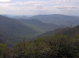
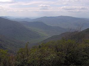
The Great Smoky Mountains are a mountain range rising along the Tennessee–North Carolina border in the southeastern United States. They are a subrange of the Appalachian Mountains, and form part of the Blue Ridge Physiographic Province. The range is sometimes called the Smoky Mountains or the...
, located
in the Southeastern United States. Formerly home to a string of small Appalachia
Appalachia
Appalachia is a term used to describe a cultural region in the eastern United States that stretches from the Southern Tier of New York state to northern Alabama, Mississippi, and Georgia. While the Appalachian Mountains stretch from Belle Isle in Canada to Cheaha Mountain in the U.S...
n
communities, the valley is now the location of the Great Smoky Mountains National Park
Great Smoky Mountains National Park
Great Smoky Mountains National Park is a United States National Park and UNESCO World Heritage Site that straddles the ridgeline of the Great Smoky Mountains, part of the Blue Ridge Mountains, which are a division of the larger Appalachian Mountain chain. The border between Tennessee and North...
headquarters and the Sugarlands Visitor Center. Lying just south of Gatlinburg, the
Sugarlands is one of the park's most popular access points.
The Sugarlands area stretches roughly from Grapeyard Ridge and Roaring Fork
Roaring Fork (Great Smoky Mountains)
Roaring Fork is a stream in the Great Smoky Mountains of Tennessee, located in the Southeastern United States. Once the site of a small Appalachian community, today the stream's area is home to the Roaring Fork Motor Nature Trail and the Roaring Fork Historic District.Like many mountain streams,...
in the
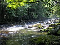
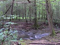
east to the slopes of Sugarland Mountain to the west. Mount Le Conte rises 5,000 feet above the valley to the south and southeast. The West Fork of the Little Pigeon River
Little Pigeon River (Tennessee)
The Little Pigeon River is a river located entirely within Sevier County, Tennessee.It rises from a series of streams which flow together on the dividing ridge between the states of Tennessee and North Carolina inside the boundary of the Great Smoky Mountains National Park. The river is subdivided...
, its source high in the mountains, slices through the Sugarlands, draining much of the valley.
When the first Euro-American settlers arrived in the early 19th century, they named the valley after the many sugar maple
Sugar Maple
Acer saccharum is a species of maple native to the hardwood forests of northeastern North America, from Nova Scotia west to southern Ontario, and south to Georgia and Texas...
trees growing in the area at the time. Syrup
Maple syrup
Maple syrup is a syrup usually made from the xylem sap of sugar maple, red maple, or black maple trees, although it can also be made from other maple species such as the bigleaf maple. In cold climates, these trees store starch in their trunks and roots before the winter; the starch is then...
was made from the sap in these trees and used as a sweetener in the days before the availability of cane sugar. While these trees were cleared by the early settlers, the sugar maple is still common throughout the park.
Geology
Precambrian
The Precambrian is the name which describes the large span of time in Earth's history before the current Phanerozoic Eon, and is a Supereon divided into several eons of the geologic time scale...
sandstone of the Ocoee Supergroup, known specifically as Roaring Fork sandstone. This rock, like other formations throughout
the Appalachian
Appalachian Mountains
The Appalachian Mountains #Whether the stressed vowel is or ,#Whether the "ch" is pronounced as a fricative or an affricate , and#Whether the final vowel is the monophthong or the diphthong .), often called the Appalachians, are a system of mountains in eastern North America. The Appalachians...
region, was formed from ancient ocean sediments
nearly one billion years ago. Erosional forces throughout the Mesozoic
Mesozoic
The Mesozoic era is an interval of geological time from about 250 million years ago to about 65 million years ago. It is often referred to as the age of reptiles because reptiles, namely dinosaurs, were the dominant terrestrial and marine vertebrates of the time...
and Cenozoic
Cenozoic
The Cenozoic era is the current and most recent of the three Phanerozoic geological eras and covers the period from 65.5 mya to the present. The era began in the wake of the Cretaceous–Tertiary extinction event at the end of the Cretaceous that saw the demise of the last non-avian dinosaurs and...
eras — especially during the last Ice Age
Ice age
An ice age or, more precisely, glacial age, is a generic geological period of long-term reduction in the temperature of the Earth's surface and atmosphere, resulting in the presence or expansion of continental ice sheets, polar ice sheets and alpine glaciers...
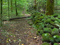
— have carried rocks of various sizes down from boulder fields high up on the surrounding mountain slopes, leaving the valley coated with a bouldery alluvium
Alluvium
Alluvium is loose, unconsolidated soil or sediments, eroded, deposited, and reshaped by water in some form in a non-marine setting. Alluvium is typically made up of a variety of materials, including fine particles of silt and clay and larger particles of sand and gravel...
. Early farmers, having to move these rocks in order plant crops, stacked them up to make crude stone walls, many of which remain today.
History
In CherokeeCherokee
The Cherokee are a Native American people historically settled in the Southeastern United States . Linguistically, they are part of the Iroquoian language family...
lore, the Sugarlands was part of the area known as "Walasi'yi", or "Frog place".
Walasi'yi included Mount Le Conte and Bull Head, as well as "the ridge extending
into Sevier County, Tennessee, between the Middle and West forks of Little Pigeon River." In the legend "Aganunitsi and the Uktena," the Shawano
Shawnee
The Shawnee, Shaawanwaki, Shaawanooki and Shaawanowi lenaweeki, are an Algonquian-speaking people native to North America. Historically they inhabited the areas of Ohio, Virginia, West Virginia, Western Maryland, Kentucky, Indiana, and Pennsylvania...
medicine man, Aganunitsi, in exchange for his freedom, seeks out the great serpent, Uktena, in hopes of snatching a magical jewel from its forehead. After searching the surrounding mountains, Aganunitsi found his way to Walasi'yi:
Going still south to Walasi'yi, the Frog place, he found a great frog squatting in the gap, but when the people who came to see it were frightened like the others and ran away from the monster he mocked at them for being afraid of a frog and went on to the next gap.
Early pioneers
of the Sugarlands. William Trentham would homestead in the Fighting Creek area, where the Sugarlands Visitor Center now stands. In subsequent decades, three communities developed in the Sugarlands valley— the Forks-of-the-River and Fighting Creek communities in the vicinity of what is now the Sugarlands Visitor Center, and the Sugarlands community proper, which lay further to the south, between the two "Quiet Walkways" opposite the Huskey Gap Trail and the Chimney picnic area. Most of the inhabitants still living in the Sugarlands when the park
Great Smoky Mountains National Park
Great Smoky Mountains National Park is a United States National Park and UNESCO World Heritage Site that straddles the ridgeline of the Great Smoky Mountains, part of the Blue Ridge Mountains, which are a division of the larger Appalachian Mountain chain. The border between Tennessee and North...
was formed were descended from these early settlers.
For much of the 19th Century, Sugarlanders lived in log cabin
Log cabin
A log cabin is a house built from logs. It is a fairly simple type of log house. A distinction should be drawn between the traditional meanings of "log cabin" and "log house." Historically most "Log cabins" were a simple one- or 1½-story structures, somewhat impermanent, and less finished or less...
s. The typical mountain cabin consisted of one room, 16' × 20', constructed of notched logs and puncheon floors. A chimney — usually made of slate and clay — rose along one wall. A lone window was on the wall opposite the chimney. Around 1900, modern frame houses slowly started replacing the log cabins.
A standard farm in the Sugarlands consisted of the cabin or house and a small vegetable garden, all of which was surrounded by a paling fence, and several outbuildings. A smokehouse and woodshed would likely be found near the kitchen, and a springhouse would straddle a nearby spring. Other likely outbuildings included barns, corn crib
Corn crib
A corn crib or corncrib is a type of granary used to dry and store corn. It is also known as a cornhouse or corn house, though this term can refer to any granary....
s (often affixed to the barns), chicken coop
Chicken coop
A chicken coop is a building where female chickens are kept. Inside there are often nest boxes for egg laying and perches on which the birds can sleep, although coops for meat birds seldom have either of these features....
s, and toolsheds. There were at least five gristmill
Gristmill
The terms gristmill or grist mill can refer either to a building in which grain is ground into flour, or to the grinding mechanism itself.- Early history :...
s in the Sugarlands, the largest belonging to Caleb Trentham. The tubwheel-powered mill of Noah "Bud" Ogle still stands today at Cherokee Orchard.
The Civil War
Appalachia
Appalachia is a term used to describe a cultural region in the eastern United States that stretches from the Southern Tier of New York state to northern Alabama, Mississippi, and Georgia. While the Appalachian Mountains stretch from Belle Isle in Canada to Cheaha Mountain in the U.S...
, the U.S. Civil War proved devastating for the Sugarlands. The mountain communities of East Tennessee (most of which were pro-Union
Union (American Civil War)
During the American Civil War, the Union was a name used to refer to the federal government of the United States, which was supported by the twenty free states and five border slave states. It was opposed by 11 southern slave states that had declared a secession to join together to form the...
) were especially vulnerable, as they were easy targets for Confederate
Confederate States of America
The Confederate States of America was a government set up from 1861 to 1865 by 11 Southern slave states of the United States of America that had declared their secession from the U.S...
raiders from North Carolina. During the war, Will Thomas
William Holland Thomas
William Holland Thomas was Principal Chief of the Eastern Band of Cherokee Indians and an officer in the Confederate States Army during the American Civil War....
— a Confederate colonel and later Cherokee chief — made improvements to the Oconaluftee Turnpike to allow Confederate marauders easier access to Sevier County. The Sugarlands would have been among the first communities approached along this road heading north from Chimney Tops
Chimney Tops
Chimney Tops is a mountain in the central Great Smoky Mountains, located in the Southeastern United States. It has an elevation of 4,800 feet . It is one of the park's most recognizable geological structures and a popular hiking destination....
.
Early in the war, Thomas' forces ascended the turnpike and occupied Gatlinburg. Thomas erected a small fort on Burg Hill in hopes of protecting salt peter mines at Alum Cave, along the northern slopes of Mount Le Conte. He was forced to withdraw, however, when a Union relief force threatened to surround the fort.
The late 19th and early 20th centuries
Ford (crossing)
A ford is a shallow place with good footing where a river or stream may be crossed by wading or in a vehicle. A ford is mostly a natural phenomenon, in contrast to a low water crossing, which is an artificial bridge that allows crossing a river or stream when water is low.The names of many towns...
of the Pigeon River had the most lucrative storefronts. Among them were Richard Reason Reagan (1830–1912), who owned a general store near the Sugarland Branch ford, and Alex Cole, who operated a storefront further up the river.
Around 1900, sawmills began moving into the area to harvest the thick forests of the Smokies. Andrew Huff had erected a sawmill in Gatlinburg, and the Little River Lumber Company began operating in the upper reaches of Little River
Little River (Tennessee)
Little River is a scenic river in Tennessee which drains a area containing some of the most spectacular scenery in the southeastern United States. The first of the river are all located within the borders of the Great Smoky Mountains National Park...
by 1908. Many Sugarlanders found employment with the latter in Elkmont
Elkmont, Tennessee
Elkmont is a region situated in the upper Little River Valley of the Great Smoky Mountains of Sevier County, in the U.S. state of Tennessee. Throughout its history, the valley has been home to a pioneer Appalachian community, a logging town, and a resort community...
, which could be reached on foot by crossing Sugarland Mountain via what is now the Huskey Gap Trail. Bark from trees cut in the Sugarlands was often used for tanning
Tanning
Tanning is the making of leather from the skins of animals which does not easily decompose. Traditionally, tanning used tannin, an acidic chemical compound from which the tanning process draws its name . Coloring may occur during tanning...
bark.
Poverty plagued much of Appalachia in the early 1900s, and the Sugarlands was no exception. Former resident Alie Newman Maples recalled in a poem:
The Sugarlands so clear and clean,
Altho our meals were mighty lean.
Pi Beta Phi
Pi Beta Phi is an international fraternity for women founded as I.C. Sorosis on April 28, 1867, at Monmouth College in Monmouth, Illinois. Its headquarters are located in Town and Country, Missouri, and there are 134 active chapters and over 330 alumnae organizations across the United States and...
women's fraternity established the Pi Beta Phi settlement school
Arrowmont School of Arts and Crafts
The Arrowmont School of Arts and Crafts is an arts and crafts center in the U.S. city of Gatlinburg, Tennessee. The oldest craft school in Tennessee, Arrowmont offers workshops in arts and crafts such as painting, woodworking, glassblowing, photography, basket weaving, and metalworking, and...
in Gatlinburg to combat poverty in the area.
The early Pi Phi teachers' scrapbooks and letters recalled the region's sub-par conditions. One remarked that the Sugarlands was a "land of poorer homes" than even Gatlinburg, itself selected for the settlement school as the community most in need. Another recalled a dining experience with a family in the Sugarlands where the food was served on "large pail lids" while chickens roamed freely through the house. Some of the area children didn't know simple childhood games, and others knew nothing about Christmas
Christmas
Christmas or Christmas Day is an annual holiday generally celebrated on December 25 by billions of people around the world. It is a Christian feast that commemorates the birth of Jesus Christ, liturgically closing the Advent season and initiating the season of Christmastide, which lasts twelve days...
. Regardless, building on the initial successes of the Gatlinburg school, the Pi Phis decided to open a school in the Sugarlands in 1920. The school was located near the old Ransom Sims place, in the vicinity of the Sugarlands Cemetery.
While the Sugarlanders were initially suspicious of the Phi Phis' intentions, they eventually welcomed the benefits of the settlement school. Its presence allowed children in Gatlinburg and the Sugarlands to get a basic education, and helped to improve the health and economy of the area.
Moonshining
By 1900, moonshining had become rampant throughout the Smokies. The dense forest, isolated coves, and ready availability of corn made mountain valleys such as the Sugarlands the perfect places tohide and operate illegal stills. Horace Kephart
Horace Kephart
Horace Kephart was an American travel writer and librarian, best known as the author of Our Southern Highlanders, about his life in the Great Smoky Mountains of western North Carolina.-Biography:...
, a writer who lived on the North Carolina side of the mountains in the early 1900s, described the Sugarlands during this period:
...a country of ill fame, hidden deep in remote gorges, difficult of access, tenanted by a sparse population who preferred to be a law unto themselves. For many a year it had been known on our side as Blockaders' Glory, which is the same as saying Moonshiners' Paradise, and we all believed it to be fitly named.
Kephart goes on to give a quasi-factual account of a North Carolina deputy's raid into the Sugarlands to find three fugitives. Kephart describes a cornfield planted on a slope "so steep that it must have been dug with mattocks and hoed on hands and knees." The residents, while polite, seemed very suspicious of the outsiders, offering no information on the three fugitives and refusing overnight lodging. The party eventually found a house to take them in for the night, but would return to North Carolina empty-handed.
While moonshining no doubt occurred, Kephart's account is probably exaggerated. Gladys Trentham Russell, who grew up in the Fighting Creek area, estimated that less than 20% of mountain families ever engaged in the practice. Those who consumed moonshine often did so for medicinal purposes. Russell did acknowledge, however, that "bootleggers" and "bad men" made the far reaches of the Sugarlands too dangerous for women and children.
The Coming of the park
Little River Railroad (Tennessee)
The Little River Railroad is a historic class III railroad that operated between Maryville and Elkmont, Tennessee during the period 1901 to 1939.-History:...
, began offering daily train service from Knoxville to Elkmont in conjunction with Knoxville's Southern Railroad. Tourists also began pouring into Gatlinburg, especially after Andrew Huff opened the Mountain View Hotel in 1916. With the arrival of tourism, Sugarlanders found a wider market for their furs and produce.
When various entities began buying up land for the national park in the 1920s and 1930s, most of the inhabitants of the Sugarlands were displaced. Russell recalls:
Most folks were happy with the prospects of selling their rocky fields and hillsides for more money than they estimated it to be worth, but some felt they didn't want to be driven from their old homeplaces at any price.
While most Sugarlanders accepted buy-out offers, a few had to be forced out via condemnation suits. Shortly after the formation of the park, the Civilian Conservation Corps
Civilian Conservation Corps
The Civilian Conservation Corps was a public work relief program that operated from 1933 to 1942 in the United States for unemployed, unmarried men from relief families, ages 18–25. A part of the New Deal of President Franklin D...
constructed a camp along the West Fork which operated from 1933–1942, and would build roads and trails in the area for the park service. The ruins of this camp remain along a bend in the Old Sugarlands Trail. The closing of the CCC camp after World War II
World War II
World War II, or the Second World War , was a global conflict lasting from 1939 to 1945, involving most of the world's nations—including all of the great powers—eventually forming two opposing military alliances: the Allies and the Axis...
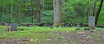
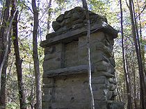
was the end of permanent human habitation in the Sugarlands. The forest quickly reclaimed the farmland, and other than a few small mountain cemeteries and the occasional odd clearing or pile of stones, few signs of the former inhabitants remain today.
Present day
U.S. Route 441
U.S. Route 441 is a spur route of U.S. Route 41. It currently runs for 939 miles from U.S. Route 41 in Miami, Florida to U.S. Route 25W in Lake City, Tennessee. Between its termini, US 441 passes through the states of Florida, Georgia, North Carolina, and Tennessee...
) — intersect at the Sugarlands Visitor Center. From this intersection, it is approximately
25 miles to Cades Cove
Cades Cove
Cades Cove is an isolated valley located in the Tennessee section of Great Smoky Mountains National Park, USA. The valley was home to numerous settlers before the formation of the national park...
in the Western Smokies, 22 miles to Newfound Gap
Newfound Gap
Newfound Gap is a mountain pass located near the center of the Great Smoky Mountains National Park of the southern Appalachian Mountains in the United States of America. Situated along the border of Tennessee and North Carolina, the state line crosses the gap, as does U.S...
, and
34 miles to Cherokee
Cherokee, North Carolina
Cherokee is a town in Swain County, North Carolina, USA, within the Qualla Boundary land trust. It is located in the Oconaluftee River Valley, near the intersection of U.S. Route 19 and U.S...
, North Carolina. Gatlinburg is just two miles to the north.
Hiking trails
The Old Sugarlands Trail, which is both a hiking and horse trail, connects the Fighting Creek area along Newfound Gap Road with the Cherokee Orchard area. The Bullhead TrailBullhead Trail
The Bullhead Trail is an American hiking trail in the Great Smoky Mountains National Park, in Sevier County, Tennessee. The trail ascends Mount Le Conte, the tallest mountain east of the Mississippi River and offers outstanding views before joining the Rainbow Falls Trail before terminating...
branches off from the Old Sugarlands Trail, crossing the slopes of Bull Head before intersecting the Boulevard Trail atop Mount Le Conte. The Huskey Gap Trail, with its trailhead along Newfound Gap Road a mile past the visitors center, ascends Sugarland Mountain to the Sugarland Mountain Trail
Sugarland Mountain Trail
The Sugarland Mountain Trail is an American hiking trail, in the Great Smoky Mountains National Park of Sevier County, Tennessee. The trail traverses Sugarland Mountain, a massive ridge running perpendicular to the main crest of the Smokies and effectively dividing the park's north-central section...
. Both the Boulevard Trail and Sugarland Mountain Trail intersect the Appalachian Trail
Appalachian Trail
The Appalachian National Scenic Trail, generally known as the Appalachian Trail or simply the AT, is a marked hiking trail in the eastern United States extending between Springer Mountain in Georgia and Mount Katahdin in Maine. It is approximately long...
along the crest of the Smokies to the south.
Two short trails labelled "Quiet Walkways" connect Newfound Gap Road with an area of stone ruins along the West Fork of the Little Pigeon River. An interpretive loop trail behind the Sugarlands Visitor Center leads past the John Ownby Cabin and the ruins of the Noah McCarter place. Cherokee Orchard Road connects US-441 in Gatlinburg to the Cherokee Orchard and Roaring Fork areas, and passes by the Noah Ogle homestead and the eastern head of the Old Sugarlands Trail.
Historical structures
The Noah Ogle PlaceNoah Ogle Place
The Noah "Bud" Ogle Place was a homestead located in the Great Smoky Mountains of Sevier County, in the U.S. state of Tennessee. The homestead presently consists of a cabin, barn, and tub mill built by mountain farmer Noah "Bud" Ogle in the late 19th-century...
at the northeastern fringe of the valley, the John Ownby Cabin near the Sugarland Visitor Center, and the Alex Cole Cabin now at Roaring Fork are the last remaining extant building from the valley's pre-park communities. Various stone foundations, chimney falls, and crude rock walls remain scattered throughout the valley, giving hints of the layout of the early Appalachian settlements. The farmland, however, has been almost wholly reclaimed by hardwood
Hardwood
Hardwood is wood from angiosperm trees . It may also be used for those trees themselves: these are usually broad-leaved; in temperate and boreal latitudes they are mostly deciduous, but in tropics and subtropics mostly evergreen.Hardwood contrasts with softwood...
forest.
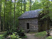
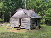
John Ownby Cabin
Built in 1860, the John Ownby CabinJohn Ownby Cabin
The John Ownby Cabin is a historic cabin in Sevier County, Tennessee, United States. Located in The Sugarlands, it lies within the boundaries of the Great Smoky Mountains National Park. It was built in 1860, and is the last surviving structure from the pre-park Forks-of-the-River community...
is the last surviving structure from the pre-park Forks-of-the-River community. Repaired in 1964, it was added to the National Register of Historic Places in 1976.
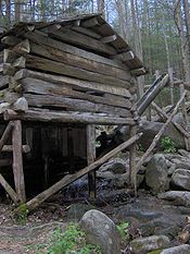
Noah Ogle Place
The Noah Ogle Place, located along LeConte Creek just south of Gatlinburg, consists of a cabin, barn, and tub millGristmill
The terms gristmill or grist mill can refer either to a building in which grain is ground into flour, or to the grinding mechanism itself.- Early history :...
that were once part of the homestead of Noah "Bud" Ogle (1863–1913). The cabin is a "saddlebag" cabin, a design in which two cabins are built around the same chimney, with both cabins consisting of one story and loft. Ogle's barn is the last remaining four-pen barn in the park, consisting of four 11 feet (3.4 m) by 11 feet (3.4 m) pens. Ogle's tub mill, one of the park's two surviving tub mills (the other is at the Alfred Reagan Place at Roaring Fork), consists of a millhouse connected via vertical shaft to a tubwheel turbine. An 80 feet (24.4 m) flume diverts water from LeConte Creek to power the mill.
Alex Cole Cabin
The Alex Cole Cabin was originally located on the east bank of the West Fork of Little Pigeon River along the old Indian Gap Road (the "Quiet Walkway" opposite the Huskey Gap Trailhead along Newfound Gap Road follows this road along the river's west bank), but was later moved to the Jim Bales Place along the Roaring Motor Nature Trail a few miles to the east. Like many Sugarlanders, Albert Alexander "Alex" Cole (1870–1958) and his sons worked for the Little River Lumber Company at Elkmont, making a weekly trek across Sugarland Mountain via what is now the Huskey Gap Trail. During the tourism boom in subsequent decades, Cole was a much sought-after mountain guide due to his knowledge of the Mount Le Conte area.External links
- Great Smoky Mountains National Park Visitor Centers — Information on operating hours, exhibits, etc. at the Sugarlands Visitor Center
- From Pi Beta Phi to Arrowmont — A site hosted by the Great Smoky Mountains Regional Project; contains valuable pre-park photos and scrapbooks relating to the Sugarlands and Gatlinburg
- The Smoky Mountain Historical Society
- The Great Smoky Mountains Association — Non-profit GSMNP partner; contains news, historical information, and photo galleries of the Sugarlands and other park locales.