
Chimney Tops
Encyclopedia
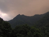
Chimney Tops is a mountain in the central Great Smoky Mountains
, located in the Southeastern United States. It has an elevation of 4,800 feet (1463 m). It is one of the park's most recognizable geological structures and a popular hiking destination.
Chimney Tops is a double-capstone knob on the eastern slope of the Sugarland Mountain massif
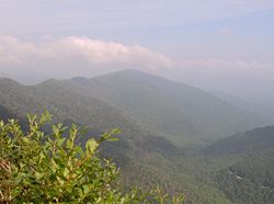
. This massif stretches north-to-south across the north-central section of the Smokies. Mount Le Conte dominates the area immediately east of Chimney Tops, and Mt. Mingus rises to the north. Thus, while the view from the summit is 360 degrees, Chimney Tops is practically "walled in" on three sides.
Like most of the Appalachian Mountains
, Chimney Tops was formed 200 million years ago when the North American and African plates collided during the Appalachian orogeny.
 The Cherokee
name for Chimney Tops is Duniskwalgunyi, or "forked antler", referring to its resemblance to the antlers of a deer. In the Cherokee legend "Aganunitsi and the Uktena", the captured medicine man, Aganunitsi, in exchange for his freedom, searches remote parts of the Smokies in hopes of finding the giant reptile, the Uktena, and seizing a powerful amulet from its forehead. In his quest, Aganunitsi searches distant gaps and peaks in the Smokies before he "went on to Duniskwalgunyi, the Gap of the Forked Antler, and to the enchanted lake of Atagahi, and at each found monstrous reptiles, but he said they were nothing."
 The Road Prong Trail, which follows the stream of the same name at the base of Chimney Tops, is one of the oldest trails in the Smokies. In the 18th and 19th centuries, this ancient path was known commonly as the Indian Gap Trail. In 1832, the Oconaluftee Turnpike was constructed between Indian Gap and Smokemont
. This road was expanded during the Civil War by Cherokee leader Col. Will Thomas
, running parallel to the modern trail.
The mountain's current name was probably given to it by residents of the Sugarlands, a valley to the north of the mountain that was home to a small Appalachian community before the national park
was formed. Before the Sugarlands was reforested, Chimney Tops was clearly visible from most of the valley. Local legend even suggested that the top of the mountain was covered in soot.
 By far the most common route to the top of Chimney Tops is the Chimney Tops Trail, which can be accessed from Newfound Gap Road (US-441). While the trailhead is clearly marked, it shouldn't be confused with the Chimneys Campground, which is a few miles to the north. The trail ends at the foot of the south capstone (the higher of the two), but various unmaintained spurs cross over to the lower summit.
Another route is to follow the Appalachian Trail
west from Newfound Gap
to the Road Prong Trail. The Road Prong Trail, following the river at the base of the mountain, connects the Appalachian Trail with the Chimney Tops Trail. This route is twice as long as the route from the Chimney Tops parking lot.
While no technical gear is needed, a short climb is necessary to reach the top of the capstones. From the summit, Mount Le Conte and Mount Kephart
dominate the view to the east and Sugarland Mountain dominates the view to the west. On a clear day, the Sugarlands valley is visible to the north.
Great Smoky Mountains
The Great Smoky Mountains are a mountain range rising along the Tennessee–North Carolina border in the southeastern United States. They are a subrange of the Appalachian Mountains, and form part of the Blue Ridge Physiographic Province. The range is sometimes called the Smoky Mountains or the...
, located in the Southeastern United States. It has an elevation of 4,800 feet (1463 m). It is one of the park's most recognizable geological structures and a popular hiking destination.
Chimney Tops is a double-capstone knob on the eastern slope of the Sugarland Mountain massif
Massif
In geology, a massif is a section of a planet's crust that is demarcated by faults or flexures. In the movement of the crust, a massif tends to retain its internal structure while being displaced as a whole...
. This massif stretches north-to-south across the north-central section of the Smokies. Mount Le Conte dominates the area immediately east of Chimney Tops, and Mt. Mingus rises to the north. Thus, while the view from the summit is 360 degrees, Chimney Tops is practically "walled in" on three sides.
Geology
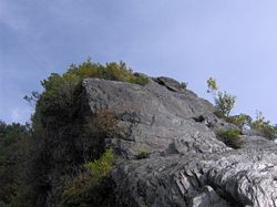
Chimney Tops is one of the few instances of a bare rock summit in the Smokies. Over the centuries, the bedrock atop the mountain has been exposed through natural weathering of the upper layers of soil strata. This rock is mostly Anakeesta Formation metamorphic rock, especially slate, phyllite, and metasiltsone. The grainy, contorted capstones offer excellent footholds and handholds for climbing.Like most of the Appalachian Mountains
Appalachian Mountains
The Appalachian Mountains #Whether the stressed vowel is or ,#Whether the "ch" is pronounced as a fricative or an affricate , and#Whether the final vowel is the monophthong or the diphthong .), often called the Appalachians, are a system of mountains in eastern North America. The Appalachians...
, Chimney Tops was formed 200 million years ago when the North American and African plates collided during the Appalachian orogeny.
History
Cherokee
The Cherokee are a Native American people historically settled in the Southeastern United States . Linguistically, they are part of the Iroquoian language family...
name for Chimney Tops is Duniskwalgunyi, or "forked antler", referring to its resemblance to the antlers of a deer. In the Cherokee legend "Aganunitsi and the Uktena", the captured medicine man, Aganunitsi, in exchange for his freedom, searches remote parts of the Smokies in hopes of finding the giant reptile, the Uktena, and seizing a powerful amulet from its forehead. In his quest, Aganunitsi searches distant gaps and peaks in the Smokies before he "went on to Duniskwalgunyi, the Gap of the Forked Antler, and to the enchanted lake of Atagahi, and at each found monstrous reptiles, but he said they were nothing."
Oconaluftee (Great Smoky Mountains)
Oconaluftee is the name of a river valley in the Great Smoky Mountains of North Carolina, located in the Southeastern United States. Formerly the site of a Cherokee village and Appalachian community, the valley's bottomland is now home to the main entrance to the North Carolina section of the...
. This road was expanded during the Civil War by Cherokee leader Col. Will Thomas
William Holland Thomas
William Holland Thomas was Principal Chief of the Eastern Band of Cherokee Indians and an officer in the Confederate States Army during the American Civil War....
, running parallel to the modern trail.
The mountain's current name was probably given to it by residents of the Sugarlands, a valley to the north of the mountain that was home to a small Appalachian community before the national park
Great Smoky Mountains National Park
Great Smoky Mountains National Park is a United States National Park and UNESCO World Heritage Site that straddles the ridgeline of the Great Smoky Mountains, part of the Blue Ridge Mountains, which are a division of the larger Appalachian Mountain chain. The border between Tennessee and North...
was formed. Before the Sugarlands was reforested, Chimney Tops was clearly visible from most of the valley. Local legend even suggested that the top of the mountain was covered in soot.
Access
Another route is to follow the Appalachian Trail
Appalachian Trail
The Appalachian National Scenic Trail, generally known as the Appalachian Trail or simply the AT, is a marked hiking trail in the eastern United States extending between Springer Mountain in Georgia and Mount Katahdin in Maine. It is approximately long...
west from Newfound Gap
Newfound Gap
Newfound Gap is a mountain pass located near the center of the Great Smoky Mountains National Park of the southern Appalachian Mountains in the United States of America. Situated along the border of Tennessee and North Carolina, the state line crosses the gap, as does U.S...
to the Road Prong Trail. The Road Prong Trail, following the river at the base of the mountain, connects the Appalachian Trail with the Chimney Tops Trail. This route is twice as long as the route from the Chimney Tops parking lot.
While no technical gear is needed, a short climb is necessary to reach the top of the capstones. From the summit, Mount Le Conte and Mount Kephart
Mount Kephart
Mount Kephart is a mountain in the central Great Smoky Mountains, located in the Southeastern United States. The Appalachian Trail crosses the mountain's south slope, making it a key destination for thru-hikers. The Jumpoff, a cliff on the northeast side of the mountain, allows for spectacular...
dominate the view to the east and Sugarland Mountain dominates the view to the west. On a clear day, the Sugarlands valley is visible to the north.