

Tennessee-Tombigbee Waterway
Encyclopedia

Waterway
A waterway is any navigable body of water. Waterways can include rivers, lakes, seas, oceans, and canals. In order for a waterway to be navigable, it must meet several criteria:...
that extends from the Tennessee River
Tennessee River
The Tennessee River is the largest tributary of the Ohio River. It is approximately 652 miles long and is located in the southeastern United States in the Tennessee Valley. The river was once popularly known as the Cherokee River, among other names...
to the junction of the Black Warrior
Black Warrior River
The Black Warrior River is a waterway in west central Alabama in the southeastern United States. The river rises in the extreme southern edges of the Appalachian Highlands and flows 178 miles to the Tombigbee River, of which the Black Warrior is the primary tributary...
-Tombigbee River
Tombigbee River
The Tombigbee River is a tributary of the Mobile River, approximately 200 mi long, in the U.S. states of Mississippi and Alabama. It is one of two major rivers, along with the Alabama River, that unite to form the short Mobile River before it empties into Mobile Bay on the Gulf of Mexico...
system near Demopolis, Alabama
Demopolis, Alabama
Demopolis is the largest city in Marengo County, Alabama, United States. The population was 7,483 at the time of the 2010 United States Census....
, United States. The Tenneessee-Tombigbee Waterway links commercial navigation from the nation’s midsection to the Gulf of Mexico
Gulf of Mexico
The Gulf of Mexico is a partially landlocked ocean basin largely surrounded by the North American continent and the island of Cuba. It is bounded on the northeast, north and northwest by the Gulf Coast of the United States, on the southwest and south by Mexico, and on the southeast by Cuba. In...
. The major features of the waterway are 10 locks
Lock (water transport)
A lock is a device for raising and lowering boats between stretches of water of different levels on river and canal waterways. The distinguishing feature of a lock is a fixed chamber in which the water level can be varied; whereas in a caisson lock, a boat lift, or on a canal inclined plane, it is...
and dam
Dam
A dam is a barrier that impounds water or underground streams. Dams generally serve the primary purpose of retaining water, while other structures such as floodgates or levees are used to manage or prevent water flow into specific land regions. Hydropower and pumped-storage hydroelectricity are...
s, a 175 feet (53.3 m) deep canal connecting the Tombigbee River watershed with the Tennessee River, and 234 miles (376.6 km) of navigation channels. Under construction for twelve years by the U.S. Army Corps of Engineers, the Tennessee-Tombigbee Waterway was completed in December 1984 at a total cost of nearly $2 billion.
The Tenn-Tom encompasses 17 public port
Port
A port is a location on a coast or shore containing one or more harbors where ships can dock and transfer people or cargo to or from land....
s and terminals, 110000 acres (445.2 km²) of land, and another 88000 acres (356.1 km²) managed by state conservation agencies for wildlife habitat
Habitat
* Habitat , a place where a species lives and grows*Human habitat, a place where humans live, work or play** Space habitat, a space station intended as a permanent settlement...
preservation and recreational use.
Although supported by southern Congressmen, the Tenn-Tom Waterway was widely criticized at its creation as an example of exorbitant spending.
Early history and construction
First proposed in the Colonial period, the idea for a commercial waterway link between the Tennessee and Tombigbee rivers did not receive serious attention until the advent of steamboatSteamboat
A steamboat or steamship, sometimes called a steamer, is a ship in which the primary method of propulsion is steam power, typically driving propellers or paddlewheels...
traffic in the early nineteenth century. As steamboat efficiency gains caused water transport costs to decline, in 1875, for the first time, engineers surveyed a potential canal route. However, they issued a negative report at that point in time, emphasizing that prohibitive cost estimates still prevented the project from economic feasibility.
Enthusiasm for the project languished until the presidency of Franklin D. Roosevelt
Franklin D. Roosevelt
Franklin Delano Roosevelt , also known by his initials, FDR, was the 32nd President of the United States and a central figure in world events during the mid-20th century, leading the United States during a time of worldwide economic crisis and world war...
. The development of the Tennessee River by TVA
TVA
-Organizations:*Tennessee Valley Authority*Toronto Vegetarian Association*Tibetan Volunteers for Animals*TVA Media, a media corporation operating out of Littleton, Colorado formerly called The Valley Authority.*Tidewater Volleyball Association-Television:...
, especially the construction of the Pickwick Lock and Dam
Pickwick Landing Dam
Pickwick Landing Dam is a hydroelectric dam on the Tennessee River in Hardin County, in the U.S. state of Tennessee. The dam is one of nine dams on the river owned and operated by the Tennessee Valley Authority, which built the dam in the 1930s as part of a New Deal-era initiative to create a...
in 1938, helped decrease Tenn-Tom's potential economic costs and increase its potential benefits. Additionally, political candidates began to favor the construction of the waterway for political reasons, that is, in order to appeal to the voters in the South
Southern United States
The Southern United States—commonly referred to as the American South, Dixie, or simply the South—constitutes a large distinctive area in the southeastern and south-central United States...
, rather than for economic reasons. As part of his "Southern Strategy
Southern strategy
In American politics, the Southern strategy refers to the Republican Party strategy of winning elections in Southern states by exploiting anti-African American racism and fears of lawlessness among Southern white voters and appealing to fears of growing federal power in social and economic matters...
" for reelection, President Nixon
Richard Nixon
Richard Milhous Nixon was the 37th President of the United States, serving from 1969 to 1974. The only president to resign the office, Nixon had previously served as a US representative and senator from California and as the 36th Vice President of the United States from 1953 to 1961 under...
included $1 million in the Corps of Engineers' 1971 budget to start construction of the Tenn-Tom. Funding shortages and legal challenges delayed construction until December 1972, but President Nixon’s efforts nevertheless initiated official Tenn-Tom waterway construction.
The U.S. Army Corps of Engineers began work on the project in 1972. During the construction process, land excavation reached about 175 feet (53.3 m) in depth. The Tenn-Tom is the largest earth-moving project in world history, requiring the excavation of nearly 310 million cubic yards of soil. (This is the equivalent of more than 100-million dump truck loads and more dirt than required in the Panama Canal
Panama Canal
The Panama Canal is a ship canal in Panama that joins the Atlantic Ocean and the Pacific Ocean and is a key conduit for international maritime trade. Built from 1904 to 1914, the canal has seen annual traffic rise from about 1,000 ships early on to 14,702 vessels measuring a total of 309.6...
.) The project was completed on December 12, 1984, nearly two years ahead of schedule.
Controversy
The $2 billion in necessary funding for the Tenn-Tom waterway was repeatedly attacked by elected representatives and political organizations. Opponents asserted that the estimated economic benefits of the waterway by the Corps of Engineers were unsupportable based on projected traffic volume. Immediately after his election, President Jimmy CarterJimmy Carter
James Earl "Jimmy" Carter, Jr. is an American politician who served as the 39th President of the United States and was the recipient of the 2002 Nobel Peace Prize, the only U.S. President to have received the Prize after leaving office...
announced a plan to slash Tenn-Tom federal funding. However, over 6,500 waterway supporters attended a public hearing held in Columbus, Mississippi
Columbus, Mississippi
Columbus is a city in Lowndes County, Mississippi, United States that lies above the Tombigbee River. It is approximately northeast of Jackson, north of Meridian, south of Tupelo, northwest of Tuscaloosa, Alabama, and west of Birmingham, Alabama. The population was 25,944 at the 2000 census...
as part of Carter's review of the waterway. This overwhelming outpouring of public support for the project led to the President withdrawing his opposition.
Additionally, a series of lawsuits were filed by the Louisville and Nashville Railroad
Louisville and Nashville Railroad
The Louisville and Nashville Railroad was a Class I railroad that operated freight and passenger services in the southeast United States.Chartered by the state of Kentucky in 1850, the L&N, as it was generally known, grew into one of the great success stories of American business...
to halt construction of the waterway. Railroad companies, who served as a major transport alternative and stood to potentially lose the most value from its creation, asserted that the waterway construction violated the National Environmental Policy Act
National Environmental Policy Act
The National Environmental Policy Act is a United States environmental law that established a U.S. national policy promoting the enhancement of the environment and also established the President's Council on Environmental Quality ....
.
Nevertheless, federal courts ruled in favor of the project.
Economic impact
When completed, the Tenn-Tom waterway’s total cost, including non-federal costs, was $1.992 billion. Given these staggering costs, before the project was completed, some political and economic commentators derided the Tenn-Tom waterway as "pork-barrel politics at its worst.”For the first few years after its creation, these criticisms appeared somewhat prudent. The Tennessee-Tombigbee Waterway opened two years ahead of schedule in the midst of an economic recession in the barge business—a factor that initially resulted in a disappointingly low use of the waterway.
However, the 1988 drought closed the Mississippi River
Mississippi River
The Mississippi River is the largest river system in North America. Flowing entirely in the United States, this river rises in western Minnesota and meanders slowly southwards for to the Mississippi River Delta at the Gulf of Mexico. With its many tributaries, the Mississippi's watershed drains...
, shifting traffic to the Tenn-Tom canal. This coincided with an economic turnaround on the Tennessee-Tombigbee corridor, wherein trade tonnage and commercial investment have increased steadily in the past several years.
Today, the two primary commodities shipped via the Tenn-Tom are coal and timber products, together comprising about 70 percent of total commercial shipping on the waterway. The Tenn-Tom also provides access to over 34 million acres (137,593.2 km²) of commercial forests and approximately two-thirds of all recoverable coal reserves in the nation. Industries that utilize these natural resources have found the Waterway to be their most cost-efficient mode of transportation. Other popular Tenn-Tom trade products include grain, gravel, sand, and iron.
According to a 2009 Troy University study, since 1996, the United States has realized a direct, indirect, and induced economic impact of nearly $43 billion due to the existence and usage of the Tenn-Tom Waterway and it has directly created more than 29,000 jobs. Without the Waterway as a viable source of transportation, an average of 284,000 additional truckloads per year would be required to handle the materials currently being shipped.
Given that the Tenn-Tom Waterway has an estimated lifetime of well over 50 years, the Waterway is expected to play a significant role in southern interstate trade for years to come.
Divide Cut
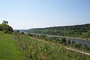
Tennessee River
The Tennessee River is the largest tributary of the Ohio River. It is approximately 652 miles long and is located in the southeastern United States in the Tennessee Valley. The river was once popularly known as the Cherokee River, among other names...
. It connects Pickwick Lake
Pickwick Lake
Pickwick Lake is the reservoir created by Pickwick Landing Dam as part of the Tennessee Valley Authority. The lake stretches from Pickwick Landing Dam to Wilson Dam....
on the Tennessee to Bay Springs Lake
Bay Springs Lake
Bay Springs Lake is a reservoir on the Tennessee-Tombigbee Waterwayin the U.S. state of Mississippi. It is impounded by the Jamie Whitten Lock and Dam. The lake is approximately nine miles long, between waterway mile markers 412 at the dam, and 421 near the entrance to the divide cut....
at Mississippi Highway 30.
It is a popular location for boaters on Pickwick Lake to waterski and wakeboard.
Locks
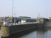
- Jamie Whitten Lock and DamJamie Whitten Lock and DamThe Jamie Whitten Lock and Dam is part of the Tennessee-Tombigbee Waterway . It is located at in south Tishomingo County, Mississippi, close to the Prentiss County line....
; formerly named Bay Springs Lock and Dam - impounds Bay Springs LakeBay Springs LakeBay Springs Lake is a reservoir on the Tennessee-Tombigbee Waterwayin the U.S. state of Mississippi. It is impounded by the Jamie Whitten Lock and Dam. The lake is approximately nine miles long, between waterway mile markers 412 at the dam, and 421 near the entrance to the divide cut.... - G. V. Montgomery LockG. V. Montgomery LockThe Gillespie V. Montgomery Lock is part of the Tennessee-Tombigbee Waterway . It is located in north Itawamba County, Mississippi, close to the Prentiss County line....
; formerly named Lock E - John Rankin LockJohn Rankin LockThe John Rankin Lock is part of the Tennessee-Tombigbee Waterway . It is located in Itawamba County, Mississippi, approximately north of Fulton....
; formerly named Lock D - Fulton LockFulton LockThe Fulton Lock is part of the Tennessee-Tombigbee Waterway. It is located close to Fulton, Mississippi....
; located in Fulton, MississippiFulton, MississippiFulton is a city in Itawamba County, Mississippi, United States. The population was 3,882 at the 2000 census. It is the county seat of Itawamba County.This city is part of the Tupelo Micropolitan Statistical Area.-Geography:...
, formerly named Lock C - Glover Wilkins LockGlover Wilkins LockThe Glover Wilkins Lock is part of the Tennessee-Tombigbee Waterway. It is located close to Smithville, Mississippi. It was named for Glover Wilkins....
; located in Smithville, MississippiSmithville, MississippiSmithville is a town in Monroe County, Mississippi, United States. The population was 882 at the 2000 census. Smithville is the birthplace of Rod Brasfield, a member of the Country Music Hall of Fame.-Geography:...
, formerly named Lock B - Amory LockAmory LockThe Amory Lock is part of the Tennessee-Tombigbee Waterway. It is located close to Amory, Mississippi....
; located in Amory, MississippiAmory, MississippiAmory is a city in Monroe County, Mississippi, United States. The population is 6,956 as of the 2000 census.-History:Amory was the first planned city in Mississippi. The Kansas City, Memphis & Birmingham Railroad needed a mid-point between Memphis, Tennessee and Birmingham, Alabama for their...
, formerly named Lock A - Aberdeen Lock and DamAberdeen Lock and DamThe Aberdeen Lock and Dam is one of four lock and dam structures on the Tennessee-Tombigbee Waterway that generally lie along the original course of the Tombigbee River. It is located east of Aberdeen in Monroe County, Mississippi and impounds Aberdeen Lake....
; located in Aberdeen, MississippiAberdeen, MississippiAberdeen is a city in Monroe County in the U.S. state of Mississippi. The population was 6,415 at the 2000 census. It is the county seat of Monroe County....
- impounds Aberdeen LakeAberdeen Lake (Mississippi)Aberdeen Lake is a lake in northeast Mississippi on the Tennessee-Tombigbee Waterway. Close to Aberdeen, it is impounded by the Aberdeen Lock and Dam.... - John C. Stennis Lock and DamJohn C. Stennis Lock and DamThe John C. Stennis Lock and Dam, formerly named Columbus Lock and Dam, is one of four lock and dam structures on the Tennessee-Tombigbee Waterway that generally lie along the original course of the Tombigbee River. It is located near Columbus, Mississippi, and impounds Columbus Lake. It is named...
; formerly named ColumbusColumbus, MississippiColumbus is a city in Lowndes County, Mississippi, United States that lies above the Tombigbee River. It is approximately northeast of Jackson, north of Meridian, south of Tupelo, northwest of Tuscaloosa, Alabama, and west of Birmingham, Alabama. The population was 25,944 at the 2000 census...
Lock and Dam - impounds Columbus LakeColumbus Lake (Mississippi)Columbus Lake is a lake in northeast Mississippi on the Tennessee-Tombigbee Waterway. Close to Columbus, it is impounded by the John C. Stennis Lock and Dam. Many people go there for the great recreational opportunities.... - Tom Bevill Lock and DamTom Bevill Lock and DamThe Tom Bevill Lock and Dam, formerly named Aliceville Lock and Dam, is one of four lock and dam structures on the Tennessee-Tombigbee Waterway that generally lie along the original course of the Tombigbee River. It is located near Aliceville, Alabama and impounds Aliceville Lake. It is named for...
; formerly named AlicevilleAliceville, AlabamaAliceville is a city in Pickens County, Alabama, United States. At the 2000 census the population was 2,567. According to the 2005 U.S. Census estimates, the city had a population of 2,465. -Geography:...
Lock and Dam - impounds Aliceville LakeAliceville LakeAliceville Lake is a reservoir in western Alabama and eastern Mississippi, on the Tennessee-Tombigbee Waterway. Close to Aliceville, it is impounded by the Tom Bevill Lock and Dam.... - Howell Heflin Lock and DamHowell Heflin Lock and DamThe Howell Heflin Lock and Dam, formerly Gainesville Lock and Dam, is one of four lock and dam structures on the Tennessee-Tombigbee Waterway that generally lie along the original course of the Tombigbee River. It is located near Gainesville, Alabama, and impounds Gainesville Lake. It is named for...
; formerly named GainesvilleGainesville, AlabamaGainesville is a town in Sumter County, Alabama, United States. At the 2000 census the population was 220.-Geography:Gainesville is located at .According to the U.S. Census Bureau, the town has a total area of , all of it land....
Lock and Dam - impounds Gainesville LakeGainesville Lake (Alabama)Gainesville Lake is a reservoir in northwest Alabama on the Tennessee-Tombigbee Waterway. Close to Gainesville, it is impounded by the Howell Heflin Lock and Dam....