

Tombigbee River
Encyclopedia

Mobile River
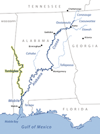
The Mobile River is located in southern Alabama in the United States. Formed out of the confluence of the Tombigbee and Alabama rivers, the approximately river drains an area of of Alabama, with a watershed extending into Mississippi, Georgia, and Tennessee. Its drainage basin is the...
, approximately 200 mi (325 km) long, in the U.S. states of Mississippi
Mississippi
Mississippi is a U.S. state located in the Southern United States. Jackson is the state capital and largest city. The name of the state derives from the Mississippi River, which flows along its western boundary, whose name comes from the Ojibwe word misi-ziibi...
and Alabama
Alabama
Alabama is a state located in the southeastern region of the United States. It is bordered by Tennessee to the north, Georgia to the east, Florida and the Gulf of Mexico to the south, and Mississippi to the west. Alabama ranks 30th in total land area and ranks second in the size of its inland...
. It is one of two major rivers, along with the Alabama River
Alabama River
The Alabama River, in the U.S. state of Alabama, is formed by the Tallapoosa and Coosa rivers, which unite about north of Montgomery.The river flows west to Selma, then southwest until, about from Mobile, it unites with the Tombigbee, forming the Mobile and Tensaw rivers, which discharge into...
, that unite to form the short Mobile River before it empties into Mobile Bay
Mobile Bay
Mobile Bay is an inlet of the Gulf of Mexico, lying within the state of Alabama in the United States. Its mouth is formed by the Fort Morgan Peninsula on the eastern side and Dauphin Island, a barrier island on the western side. The Mobile River and Tensaw River empty into the northern end of the...
on the Gulf of Mexico
Gulf of Mexico
The Gulf of Mexico is a partially landlocked ocean basin largely surrounded by the North American continent and the island of Cuba. It is bounded on the northeast, north and northwest by the Gulf Coast of the United States, on the southwest and south by Mexico, and on the southeast by Cuba. In...
. The Tombigbee watershed encompasses much of the rural coastal plain
Coastal plain
A coastal plain is an area of flat, low-lying land adjacent to a seacoast and separated from the interior by other features. One of the world's longest coastal plains is located in eastern South America. The southwestern coastal plain of North America is notable for its species diversity...
of western Alabama and northeastern Mississippi, flowing generally southward. The river provides one of the principal routes of commercial navigation in the southern United States, navigable along much of its length through locks and connected in its upper reaches to the Tennessee River
Tennessee River
The Tennessee River is the largest tributary of the Ohio River. It is approximately 652 miles long and is located in the southeastern United States in the Tennessee Valley. The river was once popularly known as the Cherokee River, among other names...
via the Tennessee-Tombigbee Waterway
Tennessee-Tombigbee Waterway
The Tennessee–Tombigbee Waterway is a 234-mile man-made, artificial waterway that extends from the Tennessee River to the junction of the Black Warrior-Tombigbee River system near Demopolis, Alabama, United States. The Tenneessee-Tombigbee Waterway links commercial navigation from the nation’s...
.
The name "Tombigbee" comes from Choctaw
Choctaw language
The Choctaw language, traditionally spoken by the Native American Choctaw people of the southeastern United States, is a member of the Muskogean family...
/itumbi ikbi/, meaning "box maker, coffin maker", from /itumbi/, "box, coffin", and /ikbi/, "maker". The river formed the eastern boundary of the historical Choctaw people lands, from the 17th century when they coalesced as a people, to the forced Indian Removal
Indian Removal
Indian removal was a nineteenth century policy of the government of the United States to relocate Native American tribes living east of the Mississippi River to lands west of the river...
by the United States in the 1830s.
Description
The river begins in north Mississippi in Itawamba CountyItawamba County, Mississippi
In 2000, there were 8,773 households out of which 33.20% had children under the age of 18 living with them, 60.30% were married couples living together, 9.90% had a female householder with no husband present, and 25.90% were non-families. 23.40% of all households were made up of individuals and...
. Historically, the beginning of the river was in northern Monroe County
Monroe County, Mississippi
-Demographics:As of the census of 2000, there were 38,014 people, 14,603 households, and 10,660 families residing in the county. The population density was 50 people per square mile . There were 16,236 housing units at an average density of 21 per square mile...
, by the confluence of Town Creek
Town Creek (Mississippi)
Town Creek, also known as Old Town Creek or West Fork Tombigbee River, is a tributary stream of the Tombigbee River in northeast Mississippi.Old Town was a Chickasaw village.-References:. Retrieved 13 June 2005.. Retrieved 21 May 2008....
(also known as West Fork Tombigbee River) and East Fork Tombigbee River
East Fork Tombigbee River
East Fork Tombigbee River was a historical name of a tributary stream of the Tombigbee River in northeast Mississippi. Its confluence with Town Creek in Monroe County was the historical beginning of the Tombigbee. Today, however, what was once known as the east fork is now designated as the...
. Today, however, what was once known as the east fork is now designated as the Tombigbee itself.
It flows east through Aberdeen Lake
Aberdeen Lake (Mississippi)
Aberdeen Lake is a lake in northeast Mississippi on the Tennessee-Tombigbee Waterway. Close to Aberdeen, it is impounded by the Aberdeen Lock and Dam....
near Aberdeen
Aberdeen, Mississippi
Aberdeen is a city in Monroe County in the U.S. state of Mississippi. The population was 6,415 at the 2000 census. It is the county seat of Monroe County....
, and Columbus Lake
Columbus Lake (Mississippi)
Columbus Lake is a lake in northeast Mississippi on the Tennessee-Tombigbee Waterway. Close to Columbus, it is impounded by the John C. Stennis Lock and Dam. Many people go there for the great recreational opportunities....
near Columbus
Columbus, Mississippi
Columbus is a city in Lowndes County, Mississippi, United States that lies above the Tombigbee River. It is approximately northeast of Jackson, north of Meridian, south of Tupelo, northwest of Tuscaloosa, Alabama, and west of Birmingham, Alabama. The population was 25,944 at the 2000 census...
. It flows through Aliceville Lake
Aliceville Lake
Aliceville Lake is a reservoir in western Alabama and eastern Mississippi, on the Tennessee-Tombigbee Waterway. Close to Aliceville, it is impounded by the Tom Bevill Lock and Dam....
on the Mississippi-Alabama border, then generally SSE across western Alabama in a highly meander
Meander
A meander in general is a bend in a sinuous watercourse. A meander is formed when the moving water in a stream erodes the outer banks and widens its valley. A stream of any volume may assume a meandering course, alternately eroding sediments from the outside of a bend and depositing them on the...
ing course, past Gainesville
Gainesville, Alabama
Gainesville is a town in Sumter County, Alabama, United States. At the 2000 census the population was 220.-Geography:Gainesville is located at .According to the U.S. Census Bureau, the town has a total area of , all of it land....
and Demopolis
Demopolis, Alabama
Demopolis is the largest city in Marengo County, Alabama, United States. The population was 7,483 at the time of the 2010 United States Census....
, where it is joined from the northeast by the Black Warrior River
Black Warrior River
The Black Warrior River is a waterway in west central Alabama in the southeastern United States. The river rises in the extreme southern edges of the Appalachian Highlands and flows 178 miles to the Tombigbee River, of which the Black Warrior is the primary tributary...
. South of Demopolis it flows generally south across southwestern Alabama, past Jackson
Jackson, Alabama
Jackson is a city in Clarke County, Alabama, United States. The population was 5,228 at the 2010 census. It is one of three wet settlements in an otherwise-dry county.-Geography:Jackson is located at coordinates . According to the U.S...
. It joins the Alabama from the north on the Mobile
Mobile County, Alabama
Mobile County[p] is a county of the U.S. state of Alabama. Its name is in honor of a tribe of Indians, the Maubila tribe . As of 2011, its population was 415,704. Its county seat is Mobile, Alabama...
-Baldwin
Baldwin County, Alabama
-2010:Whereas according to the 2010 U.S. Census Bureau:*85.7% White*9.4% Black*0.7% Native American*0.7% Asian*0.0% Native Hawaiian or Pacific Islander*1.5% Two or more races*4.4% Hispanic or Latino -2000:...
county line, approximately 30 mi (50 km) north of Mobile
Mobile, Alabama
Mobile is the third most populous city in the Southern US state of Alabama and is the county seat of Mobile County. It is located on the Mobile River and the central Gulf Coast of the United States. The population within the city limits was 195,111 during the 2010 census. It is the largest...
, to form the Mobile River.
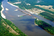
After the completion of the Tennessee-Tombigbee Waterway
Tennessee-Tombigbee Waterway
The Tennessee–Tombigbee Waterway is a 234-mile man-made, artificial waterway that extends from the Tennessee River to the junction of the Black Warrior-Tombigbee River system near Demopolis, Alabama, United States. The Tenneessee-Tombigbee Waterway links commercial navigation from the nation’s...
in 1985, much of the middle course of the river in northwestern Mississippi was diverted into the new straightened channel. Above Aberdeen Lake, the waterway flows alongside the original course of the river.
In addition to the Black Warrior, the river is joined by the Buttahatchee River
Buttahatchee River
The Buttahatchee River is a tributary of the Tombigbee River, about long, in northwestern Alabama and northeastern Mississippi in the United States...
from the east north of Columbus, Mississippi. To the South of Columbus,Mississippi, the Luxapalila Creek joins with the Tombigbee River, approximately 5.2 miles from downtown Columbus, Mississippi. Approximately 10 mi (15 km) north of Gainesville it is joined from the north by the Sipsey River
Sipsey River
The Sipsey River is a swampy low-lying river in west central Alabama. The Sipsey is surrounded by some exceptional wetland habitat. It originates near Glen Allen, and discharges into the Tombigbee River near Vienna....
. At Gainesville it is joined from the west by the Noxubee River
Noxubee River
200px|rightThe Noxubee River is a tributary of the Tombigbee River, about 140 mi long, in east-central Mississippi and west-central Alabama in the United States...
.
The Choctaw National Wildlife Refuge
Choctaw National Wildlife Refuge
The Choctaw National Wildlife Refuge is a 4,218 acre National Wildlife Refuge located along the Tombigbee River near Coffeeville, Alabama...
is along the river in southwestern Alabama, approximately 20 mi (30 km) northwest of Jackson.
The upper reaches of the Tombigbee formed the homeland of the formidable Chickasaw
Chickasaw
The Chickasaw are Native American people originally from the region that would become the Southeastern United States...
prior to their removal in 1838. The Tombigbee was the route taken by Bienville's
Jean-Baptiste Le Moyne, Sieur de Bienville
Jean-Baptiste Le Moyne de Bienvillepronounce] was a colonizer, born in Montreal, Quebec and an early, repeated governor of French Louisiana, appointed 4 separate times during 1701-1743. He was a younger brother of explorer Pierre Le Moyne d'Iberville...
1736 campaign against them.
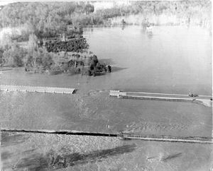
Cahaba Incident
On April 28, 1979, a tugboat named M/V Cahaba was on the Tombigbee near Demopolis, AlabamaDemopolis, Alabama
Demopolis is the largest city in Marengo County, Alabama, United States. The population was 7,483 at the time of the 2010 United States Census....
.
The tugboat was attempting to guide 2 coal barges under a flooded side-span of the old Rooster Bridge (removed years later), but the flood current was too strong. The tug and barges approached the drawbridge
Drawbridge
A drawbridge is a type of movable bridge typically associated with the entrance of a castle surrounded by a moat. The term is often used to describe all different types of movable bridges, like bascule bridges and lift bridges.-Castle drawbridges:...
-section, which failed to re-open fast enough while the river was near flood stage (drawbridges must close & re-open to allow waiting traffic to cross). The fast currents pinned the craft, starboard side, against the bridge in high waters. The force was so dramatic that it pulled the boat downward, tilting it beneath the bridge, and fully submerging it in the river. The underwater pressure blew out a port-side window in the pilot house, which began filling with water, while the captain remained at the helm. However, soon, the tugboat emerged out the other side of the bridge, and righted itself, with water pouring from the doorways and decks. One of the 2 main ventilator funnels had tilted to the center, but one engine was still running, to steer/anchor the tugboat in a flooded cornfield. Another downstream tugboat, M/V Tallapoosa rescued the captain and all 3 crew members, with the pilot, then secured the 2 barges of coal. The barges were later towed to Mobile by the same company's towboat M/V Mauvilla
Mauvilla
-Places:* the word "Mauvilla" which became: Mavilla, Mauvila, Maubila. By 1693, the name had become fairly standardized as "Mobila" or "Movila"....
, which itself became infamous, 14 years later, for the 1993 Big Bayou Canot train wreck.
Recreation
Pleasure boats, cruising America's Great LoopGreat loop
The circumnavigation of Eastern North America by water is known as The Great Loop. Also improperly referred to as the Great Circle Route , the trip varies from 5,000 miles to 7,500 miles depending on the options used. The boats used range from personal watercraft to 60-foot yachts...
, use the waterway each year in the fall.
Folklore
The river is closely associated with the Eliza BattleEliza Battle
The Eliza Battle was a Tombigbee River steamboat that ran a route between Columbus, Mississippi and Mobile, Alabama during the 1850s. She was destroyed in a fire on the river near modern Pennington, Alabama on March 1, 1858...
disaster and its associated folklore.