

TIROS
Encyclopedia

Weather satellite
The weather satellite is a type of satellite that is primarily used to monitor the weather and climate of the Earth. Satellites can be either polar orbiting, seeing the same swath of the Earth every 12 hours, or geostationary, hovering over the same spot on Earth by orbiting over the equator while...
s launched by NASA
NASA
The National Aeronautics and Space Administration is the agency of the United States government that is responsible for the nation's civilian space program and for aeronautics and aerospace research...
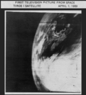
, beginning with TIROS-1 in 1960. TIROS was the first satellite that was capable of remote sensing of the Earth. This initial remote-sensing effort was significant because it enabled Earth scientists to view our planet from a new perspective: space. The program was extremely successful in proving the usefulness of satellite weather observation and in its time, perhaps considered to be too successful; causing people to question the need for many of the military spy apparatus that were in development or use at the time. TIROS demonstrated at that time that "the key to genius is often simplicity."
The 270 lb satellite
Satellite
In the context of spaceflight, a satellite is an object which has been placed into orbit by human endeavour. Such objects are sometimes called artificial satellites to distinguish them from natural satellites such as the Moon....
was launched into orbit by a Thor Able
Thor (launch vehicle)
Thor was an American space launch vehicle derived from the PGM-17 Thor intermediate-range ballistic missile. The Thor rocket was the first in a large family of space launch vehicles that came to be known as Delta...
rocket. Drum shaped with a 42 inch diameter, and height of 19 inches, the TIROS satellite carried two 6 inch long television cameras with it as it entered its nearly circular low earth orbit
Low Earth orbit
A low Earth orbit is generally defined as an orbit within the locus extending from the Earth’s surface up to an altitude of 2,000 km...
. One of the cameras had a wide-angle lens
Wide-angle lens
From a design perspective, a wide angle lens is one that projects a substantially larger image circle than would be typical for a standard design lens of the same focal length; this enables either large tilt & shift movements with a view camera, or lenses with wide fields of view.More informally,...
with an f/1.6 (focal length
Focal length
The focal length of an optical system is a measure of how strongly the system converges or diverges light. For an optical system in air, it is the distance over which initially collimated rays are brought to a focus...
) that could view 800 miles of the earth. The other camera had a telephoto lens
Telephoto lens
In photography and cinematography, a telephoto lens is a specific type of a long-focus lens in which the physical length of the lens is shorter than the focal length. This is achieved by incorporating a special lens group known as a telephoto group that extends the light path to create a long-focus...
with an f/1.8 and had a 10 to 12 power magnification
Magnification
Magnification is the process of enlarging something only in appearance, not in physical size. This enlargement is quantified by a calculated number also called "magnification"...
over the wide angle camera.
The satellite itself was stabilized in its orbit by spinning like a gyroscope
Gyroscope
A gyroscope is a device for measuring or maintaining orientation, based on the principles of angular momentum. In essence, a mechanical gyroscope is a spinning wheel or disk whose axle is free to take any orientation...
. When it first separated from the rockets third stage, it was spinning at about 136 revolutions per minute
Revolutions per minute
Revolutions per minute is a measure of the frequency of a rotation. It annotates the number of full rotations completed in one minute around a fixed axis...
(rpm). To take unblurred photographs
Motion blur
Motion blur is the apparent streaking of rapidly moving objects in a still image or a sequence of images such as a movie or animation. It results when the image being recorded changes during the recording of a single frame, either due to rapid movement or long exposure.- Photography :When a camera...
, a de-spin mechanism slowed the satellite down to 12 rpm after the orbit was accomplished.
The camera shutters
Shutter (photography)
In photography, a shutter is a device that allows light to pass for a determined period of time, for the purpose of exposing photographic film or a light-sensitive electronic sensor to light to capture a permanent image of a scene...
made possible the series of still pictures which were stored and transmitted back to earth via 2-watt
Watt
The watt is a derived unit of power in the International System of Units , named after the Scottish engineer James Watt . The unit, defined as one joule per second, measures the rate of energy conversion.-Definition:...
FM
Frequency modulation
In telecommunications and signal processing, frequency modulation conveys information over a carrier wave by varying its instantaneous frequency. This contrasts with amplitude modulation, in which the amplitude of the carrier is varied while its frequency remains constant...
transmitters as the satellite approached one of its ground command points. After transmission, the tape was erased or cleaned and readied for more recording.
TIROS continued as the ESSA
Environmental Science Services Administration
The U. S. Environmental Science Services Administration was a United States Federal executive agency created in 1965 as part of a reorganization of the United States Department of Commerce...
TIROS Operational System, and was eventually succeeded by the NOAA ITOS (Improved TIROS Operational System), or TIROS-M, and then by the TIROS-N and Advanced TIROS-N series of satellites. The naming of the satellite becomes a little confusing because the satellites share the same name as the over-seeing organization, such as ESSA
Environmental Science Services Administration
The U. S. Environmental Science Services Administration was a United States Federal executive agency created in 1965 as part of a reorganization of the United States Department of Commerce...
& ESSA 1 and NOAA
National Oceanic and Atmospheric Administration
The National Oceanic and Atmospheric Administration , pronounced , like "noah", is a scientific agency within the United States Department of Commerce focused on the conditions of the oceans and the atmosphere...
& NOAA M. NOAA-N Prime is the last in the TIROS series of NOAA satellites that observe Earth’s weather and the environment.
Participants in this satellite project included the United States National Aeronautics and Space Administration, United States Army Signal Research and Development Lab
United States Army Signal Corps
The United States Army Signal Corps develops, tests, provides, and manages communications and information systems support for the command and control of combined arms forces. It was established in 1860, the brainchild of United States Army Major Albert J. Myer, and has had an important role from...
, Radio Corporation of America, the United States Weather Bureau
National Weather Service
The National Weather Service , once known as the Weather Bureau, is one of the six scientific agencies that make up the National Oceanic and Atmospheric Administration of the United States government...
, and the United States Naval Photographic Interpretation Center
National Geospatial-Intelligence Agency
The National Geospatial-Intelligence Agency is an agency of the federal government of the United States with the primary mission of collecting, analyzing and distributing geospatial intelligence in support of national security. NGA was formerly known as the National Imagery and Mapping Agency ...
.
- TIROS-1TIROS-1TIROS I was the first successful weather satellite, and the first of a series of Television Infrared Observation Satellites...
(A)- launched April 1, 1960, suffered electrical system failure on June 15, 1960 - TIROS-2TIROS-2TIROS 2 was a spin-stabilized meteorological satellite. It was the second in a series of Television Infrared Observation Satellite. TIROS 2 was launched on 11 November 1960 at 6:13 a.m., by a Thor-Delta rocket from Cape Canaveral, Florida. The spacecraft functioned nominally until 22 January 1961...
(B)- launched November 23, 1960, failed January 22, 1961 - TIROS-3 (C)- launched July 12, 1961, deactivated February 28, 1962
- TIROS-4 (D)- launched February 8, 1962, failed on June 30, 1962 (both cameras failed earlier)
- TIROS-5 (E)- launched June 19, 1962, failed on May 13, 1963
- TIROS-6 (F)- launched September 18, 1962, failed October 21 1963
- TIROS-7 (G)- launched June 19, 1963, deactivated June 3, 1968
- TIROS-8 (H)- launched December 21, 1963, deactivated July 1, 1967
- TIROS-9 (I)- launched January 1, 1965, failed February 15 1967. First Tiros satellite in near-polar orbit
- TIROS-10 (OT-1)- launched July 2, 1965, deactivated July 31, 1966
As of June 2009, all TIROS satellites launched between 1960 and 1965 (with the exception of TIROS-7) are still in orbit.
TIROS Operational System
- ESSA-1ESSA-1ESSA-1 was a spin-stabilized operational meteorological satellite. ESSA-1 was launched on 3 February 1966 at 07:41 UTC. It was launched atop of a Delta rocket from Cape Canaveral, Florida. The spacecraft had a mass of at the time of launch. ESSA-1 had an inclination of 97.91, and an orbited the...
(OT-3) - ESSA-2 (OT-2)
- ESSA-3 (TOS-A)
- ESSA-4 (TOS-B)
- ESSA-5 (TOS-C)
- ESSA-6 (TOS-D)
- ESSA-7 (TOS-E)
- ESSA-8ESSA-8ESSA-8 was a weather satellite launched by NASA on December 15, 1968. It operated for 2,644 days until it was deactivated on March 12, 1976. ESSA-8 was launched from Vandenberg Air Force Base, CA....
(TOS-F) - ESSA-9ESSA-9ESSA-9, also known as TOS-G, was a meteorological satellite. ESSA-9 replaced the ESSA-7 satellite.-Launch & orbit:The ESSA-9 was launched on a three stage Delta rocket from Cape Canaveral, Florida. The launch occurred at 07:47 UTC on 26 February 1969. The spacecraft was placed in a sun-synchronous...
(TOS-G)
ITOS/TIROS-M
- TIROS-M (ITOS-1) January 23, 1970 launch
- NOAA-1 (ITOS-A) December 11, 1970 launch
- ITOS-B October 21, 1971 launch; unusable orbit
- ITOS-C
- NOAA-2 (ITOS-D) October 15, 1972 launch
- ITOS-E July 16, 1973 launch, failed to orbit
- NOAA-3 (ITOS-F) November 6, 1973 launch
- NOAA-4NOAA-4NOAA-4, also known as ITOS-G was a weather satellite operated by the National Oceanic and Atmospheric Administration . It was part of a series of satellites called ITOS, or improved TIROS. NOAA-4 was launched on a Delta rocket on 15 November 1974. The launch carried two other satellites:...
(ITOS-G) November 15, 1974 launch - NOAA-5 (ITOS-H) July 29, 1976 launch
TIROS-N
- TIROS-N Launched October 13, 1978
- NOAA-6 (A) Launched June 27, 1979
- NOAA-BNOAA-BNOAA-B was a failed mission and a destroyed satellite that was launched on May 29, 1980. It became space debris. It was considered a failure because of its very elliptical orbit.-Launch Problems:...
Launched May 29, 1980. It failed to achieve a usable orbit because of a booster engine anomaly. - NOAA-7NOAA-7NOAA-7 was launched on 23 June 1981 from Vandenberg Air Force Base, California. NOAA-7 was launched atop an Atlas F rocket. Launch occurred at 3:53am PST. Its mass was . It had an orbital time of 102 minutes at an inclination of 98.9, a perigee of and an apogee of...
(C) Launched June 23, 1981
Advanced TIROS-N
- NOAA-8 (E) NOAA-E was launched March 28, 1983 out of sequence (before NOAA-D) to get the first US search and rescue satellite operational.
- NOAA-9 (F) Launched December 12, 1984
- NOAA-10 (G) Launched September 17, 1986
- NOAA-11 (H) Launched September 24, 1988
- NOAA-12 (D) NOAA-D was launched May 14, 1991 and deactivated on August 10, 2007 setting an extended lifetime record of over 16 years.
- NOAA-13 (I) Launched August 9, 1993; two weeks after launch the spacecraft suffered a catastrophic power system anomaly.
- NOAA-14 (J) Launched December 30, 1994
- NOAA-15NOAA-15NOAA-15 is one of the NASA-provided TIROS series of weather forecasting satellite run by NOAA. It was launched on 13 May 1998, and is currently operational, in a sun-synchronous orbit, 807 km above the Earth, orbiting every 101 minutes...
(K) Launched May 13, 1998 - NOAA-16NOAA-16NOAA-16 is one of the NASA-provided TIROS series of weather forecasting satellite run by NOAA. It was launched on 21 September 2000, and is currently operational, in a sun-synchronous orbit, 849 km above the Earth, orbiting every 102 minutes. It hosts the AMSU, AVHRR and High Resolution...
(L) Launched September 21, 2000 - NOAA-17NOAA-17NOAA-17 is a weather forecasting satellite run by NOAA. It was launched on 24 June 2002, and is currently operational, in a sun-synchronous orbit, 824 km above the Earth, orbiting every 101 minutes. It hosts the AMSU, AVHRR and High Resolution Infrared Radiation Sounder instruments.APT...
(M) Launched June 24, 2002 - NOAA-18NOAA-18NOAA-18 is a weather forecasting satellite run by NOAA. NOAA-N was launched on May 20, 2005, into a sun-synchronous orbit at an altitude of 854 km above the Earth, with an orbital period of 102 minutes. It hosts the AMSU-A, MHS, AVHRR and High Resolution Infrared Radiation Sounder instruments, as...
(N) Launched May 20, 2005 - NOAA-19NOAA-19NOAA-19, designated NOAA-N prior to launch, is the last of the United States National Oceanic and Atmospheric Administration's POES series of weather satellites...
(N Prime) Launched February 6, 2009