

Swyre Head, Lulworth
Encyclopedia
Jurassic Coast
The Jurassic Coast is a World Heritage Site on the English Channel coast of southern England. The site stretches from Orcombe Point near Exmouth in East Devon to Old Harry Rocks near Swanage in East Dorset, a distance of ....
between Bat's Head
Bat's Head
Bat's Head is a chalk headland on the Dorset coast in southern England, located between Swyre Head and Durdle Door to the east, and White Nothe to the west.There is a small but very visible cave at the base of the headland known as Bat's Cave...
to the west and Durdle Door
Durdle Door
Durdle Door is a natural limestone arch on the Jurassic Coast near Lulworth in Dorset, England. It is privately owned by the Welds, a family who own in Dorset in the name of the Lulworth Estate. It is open to the public...
to the east, close to Lulworth
Lulworth
Lulworth is the popular name for an area on the coast of Dorset, South West England notable for its castle and cove. However there is no actual place or feature called simply "Lulworth", the villages are East and West Lulworth and the coastal feature is Lulworth Cove.See:*East Lulworth *Lulworth...
(further to the east) in Dorset
Dorset
Dorset , is a county in South West England on the English Channel coast. The county town is Dorchester which is situated in the south. The Hampshire towns of Bournemouth and Christchurch joined the county with the reorganisation of local government in 1974...
, England
England
England is a country that is part of the United Kingdom. It shares land borders with Scotland to the north and Wales to the west; the Irish Sea is to the north west, the Celtic Sea to the south west, with the North Sea to the east and the English Channel to the south separating it from continental...
. Swyre Head is located approximately 13 kilometers east of Weymouth and 14 kilometers west of Swanage
Swanage
Swanage is a coastal town and civil parish in the south east of Dorset, England. It is situated at the eastern end of the Isle of Purbeck, approximately 10 km south of Poole and 40 km east of Dorchester. The parish has a population of 10,124 . Nearby are Ballard Down and Old Harry Rocks,...
.
Confusingly, it has the same name as the highest point
Swyre Head
Swyre Head is the highest point of the Purbeck Hills and the Isle of Purbeck in Dorset, on the south coast of England. The hill Swyre Head lies about two kilometres southwest of the village Kingston, about five kilometres south of Corfe Castle and eight kilometres west of Swanage.Although not very...
of the Purbeck Hills
Purbeck Hills
The Purbeck Hills and South Dorset Downs are a ridge of chalk downs in Dorset, England. The hills extend from the Dorset Downs west of Dorchester, where the River Frome begins to form a valley dividing them from the larger area of downland to the north. The ridge then runs east through the Isle...
in the Isle of Purbeck
Isle of Purbeck
The Isle of Purbeck, not a true island but a peninsula, is in the county of Dorset, England. It is bordered by the English Channel to the south and east, where steep cliffs fall to the sea; and by the marshy lands of the River Frome and Poole Harbour to the north. Its western boundary is less well...
(actually a peninsula rather than an island), where this Swyre Head by Kingston
Kingston, Purbeck, Dorset
Kingston is a small village on the Isle of Purbeck in the county of Dorset in southern England.-Location:Kingston is situated about two miles south of Corfe Castle and five miles west of Swanage. The village of Kingston is situated on a hill near Swyre Head, the highest point of the Purbeck Hills...
is also located.
The cliffs are of chalk
Chalk
Chalk is a soft, white, porous sedimentary rock, a form of limestone composed of the mineral calcite. Calcite is calcium carbonate or CaCO3. It forms under reasonably deep marine conditions from the gradual accumulation of minute calcite plates shed from micro-organisms called coccolithophores....
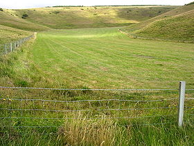
and are steep, with grassland and a footpath above. The footpath is steeply undulating over Swyre Head. Despite the steepness, it is popular for walks and the scenery is spectacular. The cliff cuts into the hill that forms Swyre Head at this point.
The area between Swyre Head and Durdle Door is aptly known as "Scratchy Bottom" because of its steepness.