
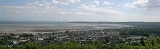
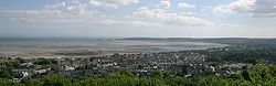
Swansea Bay
Encyclopedia
Headlands and bays
Headlands and bays are two related features of the coastal environment.- Geology and geography :Headlands and bays are often found on the same coastline. A bay is surrounded by land on three sides, whereas a headland is surrounded by water on three sides. Headlands are characterized by high,...
on the Bristol Channel
Bristol Channel
The Bristol Channel is a major inlet in the island of Great Britain, separating South Wales from Devon and Somerset in South West England. It extends from the lower estuary of the River Severn to the North Atlantic Ocean...
on the South
South Wales
South Wales is an area of Wales bordered by England and the Bristol Channel to the east and south, and Mid Wales and West Wales to the north and west. The most densely populated region in the south-west of the United Kingdom, it is home to around 2.1 million people and includes the capital city of...
Wales
Wales
Wales is a country that is part of the United Kingdom and the island of Great Britain, bordered by England to its east and the Atlantic Ocean and Irish Sea to its west. It has a population of three million, and a total area of 20,779 km²...
coast. Places on the bay include Mumbles
Mumbles
Mumbles or The Mumbles is an area and community in Swansea, Wales which takes its name from the adjacent headland stretching into Swansea Bay...
, Swansea
Swansea
Swansea is a coastal city and county in Wales. Swansea is in the historic county boundaries of Glamorgan. Situated on the sandy South West Wales coast, the county area includes the Gower Peninsula and the Lliw uplands...
and Port Talbot
Port Talbot
Port Talbot is a town in Neath Port Talbot, Wales. It had a population of 35,633 in 2001.-History:Port Talbot grew out of the original small port and market town of Aberafan , which belonged to the medieval Lords of Afan. The area of the parish of Margam lying on the west bank of the lower Afan...
. The River Neath
River Neath
River Neath is a river in south Wales running south west from its source in the Brecon Beacons National Park to its mouth at Baglan Bay below Briton Ferry on the east side of Swansea Bay.Several minor rivers rise on the southern slopes of Fforest Fawr...
, River Tawe
River Tawe
The River Tawe is a river in South Wales. It flows in a principally south-westerly direction for some from its source below Moel Feity in the Old Red Sandstone hills of the western Brecon Beacons to the Bristol Channel at Swansea. Its main tributaries are the right bank Upper and Lower Clydach...
, River Afan
River Afan
The River Afan is a river in southwest Wales whose river valley formed the territory of the medieval Lords of Afan. The town of Aberavon grew up on the banks of the river, and was later subsumed by the larger centre of population known as Port Talbot...
and Blackpill stream flow into the bay.
Swansea Bay (and all of the upper reaches of the Bristol Channel
Bristol Channel
The Bristol Channel is a major inlet in the island of Great Britain, separating South Wales from Devon and Somerset in South West England. It extends from the lower estuary of the River Severn to the North Atlantic Ocean...
) experiences one of the largest tidal range
Tidal range
The tidal range is the vertical difference between the high tide and the succeeding low tide. Tides are the rise and fall of sea levels caused by the combined effects of the gravitational forces exerted by the Moon and the Sun and the rotation of the Earth...
s in the world with a maximum range of about 10 m. The shipping ports in Swansea Bay are Swansea Docks
Swansea docks
Swansea Docks is the collective name for several docks in Swansea, Wales. The Swansea docks are located immediately south east of Swansea city centre. In the mid-19th century the port was exporting 60% of the world's copper from factories situated in the Tawe valley...
, Port Talbot Docks
Port Talbot Docks
The port of Port Talbot is located on the River Afan estuary next to Port Talbot Steelworks in the industrial town of Port Talbot, South Wales. The whole basin complex covers about , consisting of: an inner set of floating docks, developed from 1834 onwards; and an outer tidal basin, completed in...
and Briton Ferry
Briton Ferry
Briton Ferry is a town and community in the county borough of Neath Port Talbot, Wales. The town encompasses the electoral wards of Briton Ferry East and Briton Ferry West....
wharfs.
History
OysterOyster
The word oyster is used as a common name for a number of distinct groups of bivalve molluscs which live in marine or brackish habitats. The valves are highly calcified....
fishing was once an important industry in Swansea Bay, employing 600 people at its height in the 1860s. However, overfishing, disease
Disease
A disease is an abnormal condition affecting the body of an organism. It is often construed to be a medical condition associated with specific symptoms and signs. It may be caused by external factors, such as infectious disease, or it may be caused by internal dysfunctions, such as autoimmune...
and pollution
Pollution
Pollution is the introduction of contaminants into a natural environment that causes instability, disorder, harm or discomfort to the ecosystem i.e. physical systems or living organisms. Pollution can take the form of chemical substances or energy, such as noise, heat or light...
had all but wiped out the oyster population by 1920. In 2005 plans were announced to reintroduce the Oyster farming
Oyster farming
Oyster farming is an aquaculture practice in which oysters are raised for human consumption. Oyster farming most likely developed in tandem with pearl farming, a similar practice in which oysters are farmed for the purpose of developing pearls...
industry.
Beaches
The bay is lined with sandy beachBeach
A beach is a geological landform along the shoreline of an ocean, sea, lake or river. It usually consists of loose particles which are often composed of rock, such as sand, gravel, shingle, pebbles or cobblestones...
es. Each stretch of beach within the bay has its own individual name:
- Aberavon BeachAberavon BeachAberavon Beach, also known as Aberavon Sands is three-mile stretch of sandy beach located on the north-eastern edge of Swansea Bay in Sandfields, Port Talbot, Wales. With its high breaker waves, it is popular with surfers...
- Baglan BayBaglan BayBaglan Bay is a part of the Swansea Bay coastline and a district of Neath Port Talbot county borough, Wales. The area currently has no inhabitants and is entirely occupied by industrial and commercial developments. Baglan Bay is also the name of a local government community coterminous with the...
- Jersey Marine Beach
- Swansea BeachSwansea BeachSwansea Beach stretches for five miles along Swansea Bay between the Maritime Quarter and the "Knab Rock" near Mumbles. It is backed by a promenade/cycle track and a coastal road. The southern section of the Swansea Bay beach between Blackpill and Mumbles is designated Site of Special Scientific...
- Mumbles BeachMumbles BeachMumbles Beach is a very small sheltered area of sand and rock pools sandwiched between Swansea Bay beach and Bracelet Bay in the south eastern corner of the Gower Peninsula, Swansea, Wales....
Pollution
For the last two decades of the 20th century, the bay was blighted by pollutionPollution
Pollution is the introduction of contaminants into a natural environment that causes instability, disorder, harm or discomfort to the ecosystem i.e. physical systems or living organisms. Pollution can take the form of chemical substances or energy, such as noise, heat or light...
, partly from the surrounding heavy industry and partly from sewerage
Sanitary sewer
A sanitary sewer is a separate underground carriage system specifically for transporting sewage from houses and commercial buildings to treatment or disposal. Sanitary sewers serving industrial areas also carry industrial wastewater...
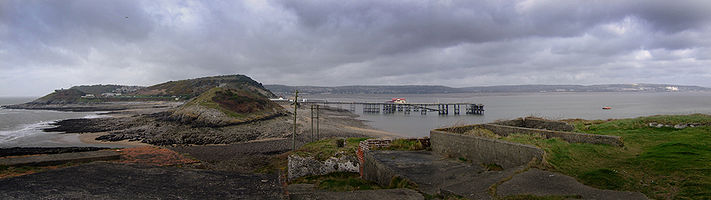
outlets being sited at inappropriate locations including the main one that was located just seaward of Mumbles Lighthouse
Mumbles Lighthouse
Mumbles Lighthouse is a lighthouse located in Mumbles, near Swansea. The structure, which sits on the outer of two islands off Mumbles Head, is clearly visible from any point along the five mile sweep of Swansea Bay...
. A pumping station
Pumping station
Pumping stations are facilities including pumps and equipment for pumping fluids from one place to another. They are used for a variety of infrastructure systems, such as the supply of water to canals, the drainage of low-lying land, and the removal of sewage to processing sites.A pumping station...
inside the cliff adjacent to Knab Rock brought all of Swansea city's effluent in a raw form to this point. Adding to the problem was the natural current flow of the waters in the Bay which often did not move the polluted waters further out to sea. Ironically, the outgoing tide did not carry the raw sewage
Sewage
Sewage is water-carried waste, in solution or suspension, that is intended to be removed from a community. Also known as wastewater, it is more than 99% water and is characterized by volume or rate of flow, physical condition, chemical constituents and the bacteriological organisms that it contains...
down the adjacent Bristol Channel
Bristol Channel
The Bristol Channel is a major inlet in the island of Great Britain, separating South Wales from Devon and Somerset in South West England. It extends from the lower estuary of the River Severn to the North Atlantic Ocean...
, but instead cause it to be sucked in around the circumference of the Bay and only then out down the Channel. If not fully discharged on that tide, the incoming tide would then push the same effluent
Wastewater
Wastewater is any water that has been adversely affected in quality by anthropogenic influence. It comprises liquid waste discharged by domestic residences, commercial properties, industry, and/or agriculture and can encompass a wide range of potential contaminants and concentrations...
up the Channel, and once again circulate around the Bay. Efforts were made by the local authority to reduce the pollution in the Bay but care had to be taken to ensure the pollution did not move to the popular beach resorts in south Gower
Gower Peninsula
Gower or the Gower Peninsula is a peninsula in south Wales, jutting from the coast into the Bristol Channel, and administratively part of the City and County of Swansea. Locally it is known as "Gower"...
instead.
This original sewer outlet was finally made inactive in around 1996 following the construction of a brand new pipeline which ran all the way back around the Bay following the line of the old Mumbles Railway as far as Beach Street, along the sea-side of the Maritime Quarter
Maritime Quarter
The Maritime Quarter, or Swansea Marina, is a residential area of Swansea, Wales, UK located immediately south of the city centre shopping core. It falls within Swansea's Castle ward...
and through Swansea Docks
Swansea docks
Swansea Docks is the collective name for several docks in Swansea, Wales. The Swansea docks are located immediately south east of Swansea city centre. In the mid-19th century the port was exporting 60% of the world's copper from factories situated in the Tawe valley...
to a new £90 million sewage treatment
Sewage treatment
Sewage treatment, or domestic wastewater treatment, is the process of removing contaminants from wastewater and household sewage, both runoff and domestic. It includes physical, chemical, and biological processes to remove physical, chemical and biological contaminants...
plant at Crymlyn Burrows
Crymlyn Burrows
Crymlyn Burrows is an area of land in Wales, UK to the east of Swansea city centre, and south of Crymlyn Bog. It is bounded by Jersey Marine Beach to the south and the River Neath to the east...
near Port Tennant
Port Tennant
Port Tennant is a suburban district of Swansea, Wales, falling within the St. Thomas ward. Port Tennant lies at the southern foot of Kilvey Hill just east of St. Thomas and is bounded by the Fabian Way to the south. It is a mostly residential area....
from which a new outlet was made, extending further out to sea. As a consequence of the huge improvement these works have made, it is hoped that Swansea Bay will achieve Blue Flag Beach
Blue Flag beach
The Blue Flag is a certification by the Foundation for Environmental Education that a beach or marina meets its stringent standards.The Blue Flag is a trademark owned by FEE which is a not-for-profit, non-governmental organisation consisting of 65 organisations in 60 member countries in Europe,...
status sometime in the latter half of the millennium decade. Aberavon beach was awarded Blue Flag status in December 2007.
Power generation
There is a gas-fired power stationBaglan Bay power station
Baglan Bay power station is a 525MWe gas-fired power station situated on Baglan Moors just west of Port Talbot in Wales.-History:The power was built on the site of the former Isopropanol BP chemicals in September 2003, costing £300m. At the time of its development, it was considered the most...
located just inland at Baglan Bay. A new biomass
Biomass
Biomass, as a renewable energy source, is biological material from living, or recently living organisms. As an energy source, biomass can either be used directly, or converted into other energy products such as biofuel....
power station has been approved for construction near the coast at Port Talbot.
Future plans
Swansea Bay (along with the rest of the UK) has one of the highest tidal ranges in the world. This offers a potential for electricity generation using tidal lagoons. A proposal has been put forward by Tidal Electric for a tidal lagoonTidal power
Tidal power, also called tidal energy, is a form of hydropower that converts the energy of tides into useful forms of power - mainly electricity....
to be constructued. The tidal lagoon would be sited about a mile offshore and would be about 5 square kilometres in size.
In addition to tidal power, construction of an offshore windfarm
WindFarm
WindFarm is wind energy software used to analyse, design, optimise and visualise wind farms. It calculates and optimises the energy yield subject to natural, planning and engineering constraints. WindFarm has the wind modelling software MS-Micro integrated. MS-Micro is based on the same...
in the Bay has been approved, but construction has now been deferred owing to the costs involved. The windfarm was to have been sited at Scarweather Sands, about three miles off the coast and visible from Porthcawl
Porthcawl
Porthcawl is a town on the south coast of Wales in the county borough of Bridgend, 25 miles west of the capital city, Cardiff and 19 miles southeast of Swansea...
.
External links
- Swansea Bay Official site from South West Wales Tourist Board
- Swansea Bay: Explore Gower
- Visit Swansea Bay
- An interactive, social networking and tourism web site based on the Gower Peninsula.
- Forces of Nature: Swansea Bay: Beach Information
- Swansea Bay
- Tidal Lagoon Presentation
- www.geograph.co.uk : photos of Swanse Bay and surrounding area