

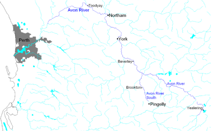
Avon River (Western Australia)
Encyclopedia
River
A river is a natural watercourse, usually freshwater, flowing towards an ocean, a lake, a sea, or another river. In a few cases, a river simply flows into the ground or dries up completely before reaching another body of water. Small rivers may also be called by several other names, including...
in Western Australia
Western Australia
Western Australia is a state of Australia, occupying the entire western third of the Australian continent. It is bounded by the Indian Ocean to the north and west, the Great Australian Bight and Indian Ocean to the south, the Northern Territory to the north-east and South Australia to the south-east...
. It is a tributary
Tributary
A tributary or affluent is a stream or river that flows into a main stem river or a lake. A tributary does not flow directly into a sea or ocean...
of the Swan River
Swan River (Western Australia)
The Swan River estuary flows through the city of Perth, in the south west of Western Australia. Its lower reaches are relatively wide and deep, with few constrictions, while the upper reaches are usually quite narrow and shallow....
totalling 280 kilometres in length, with a catchment area of 125,000 square kilometres.
Catchment area
Lake YealeringYealering, Western Australia
Yealering is a town in the Wheatbelt region of Western Australia, approximately 220km south-east of Perth between the towns of Wickepin and Corrigin. It is located beside a lake of the same name. While the town's population is small, it services a large agricultural district in the northern...
in the Shire of Wickepin
Shire of Wickepin
The Shire of Wickepin is a Local Government Area in the Wheatbelt region of Western Australia, east of Narrogin and about southeast of the state capital, Perth. The Shire covers an area of , and its seat of government is the town of Wickepin.-History:...
is the point of origin for the upper Avon river, and the catchment size above the confluence with the Salt River at Yenyenning Lake is 91 500 km2.
The basin covers much of West Australian wheatbelt and extends beyond that in some areas near almost-always-dry Lake Moore in the northeast, water is received regularly from only the extreme western edge of the basin. Indeed, until an abnormally wet year in 1963 it was not realised that the northeastern part of the basin beyond Wongan Hills
Wongan Hills, Western Australia
Wongan Hills is a town in the Shire of Wongan-Ballidu, in the Wheatbelt region of Western Australia. The town is approximately 182 km north of the State capital Perth, at an altitude of 286 metres....
ever drained water into the river. Under present climatic conditions, it is almost impossible to produce runoff from anywhere outside the extreme west of the basin because the amount of rain required to fall before runoff would begin is as high or higher than the mean annual rainfall.
Soils
Due to the extraordinary age of the soilSoil
Soil is a natural body consisting of layers of mineral constituents of variable thicknesses, which differ from the parent materials in their morphological, physical, chemical, and mineralogical characteristics...
s in the basin (which is on the extremely ancient Yilgarn Craton
Yilgarn craton
The Yilgarn Craton is a large craton which constitutes the bulk of the Western Australian land mass. It is bounded by a mixture of sedimentary basins and Proterozoic fold and thrust belts...
), the rooting density of native flora is very high and its average specific discharge probably the lowest of any basin of comparable size in the world. The extreme age of the soils also means that, at least after clearing for agriculture, almost all rivers in the basin have salinities above 0.3% (one tenth that of the oceans and eight times that necessary to qualify as "fresh" water) and some much more than that.
Passing through some of the oldest settled European agricultural areas in Western Australia, the catchment area has extensive soil salinity issues, which have attracted governmental programmes to alleviate the loss of agricultural lands. Catchment groups that oversee projects in the tributary parts of the river have had considerable support and funding from commercial and non-governmental sources as well.
Tributaries
Thirty creeks and rivers flow into the Avon, some of the larger tributariesTributary
A tributary or affluent is a stream or river that flows into a main stem river or a lake. A tributary does not flow directly into a sea or ocean...
include the Dale River
Dale River (Western Australia)
Dale River was named after Robert Dale, the first European exlorer to venture into the Darling Ranges in Western Australia in 1829.The Dale river is a tributary of the Avon river, it joins the Avon 10 km west of Beverley near the Avondale Agricultural Research Station.Tributaries of the Dale...
, Brockman River
Brockman River
Brockman River is a river in wheatbelt region of Western Australia that rises north of Bindoon Hill and then flows in a southerly direction. The river crosses the Great Northern Highway near the Bindoon-Moora Road turn off then travels parallel with the highway as it continues southward...
, Mortlock River
Mortlock River
The Mortlock River is a river in the Wheatbelt of Western Australia.The headwaters of the river rise near Belmunging then flow in a northerly direction crossing the Goldfields Road and continuing in a north westerly direction to finally flow parallel to the Northam York Road and crossing Great...
and the Mackie River
Mackie River
The Mackie River is a river in the Wheatbelt region of Western Australia. The river is ephemeral and flows actively following rain events in winter and spring, the water discharged is saline....
. Most of these watercourese are ephemeral
Ephemeral
Ephemeral things are transitory, existing only briefly. Typically the term is used to describe objects found in nature, although it can describe a wide range of things....
and only flow after rain events in winter and spring. Some permanent pools exist along the course of the river including Robins Pool, Long Pool, Cobblers Pool and Jimperding Pool.
Valley
The Avon River Valley is the third and final route for the Eastern Railway line through the Darling ScarpDarling Scarp
The Darling Scarp, also referred to as the Darling Range or Darling Ranges, is a low escarpment running north-south to the east of the Swan Coastal Plain and Perth, Western Australia...
between Midland
Midland, Western Australia
Midland is a suburb in the Perth, Western Australia metropolitan area, as well as the regional centre for the City of Swan local government area that covers the Swan Valley and parts of the Darling Scarp to the east. It is situated at the intersection of Great Eastern Highway and Great Northern...
and Northam
Northam, Western Australia
Northam is a town in Western Australia, situated at the confluence of the Avon and Mortlock Rivers, about north-east of Perth in the Avon Valley. At the 2006 census, Northam had a population of 6,009. Northam is the largest town in the Avon region...
, having been constructed in the 1960s.
It is the site of an annual whitewater
Whitewater
Whitewater is formed in a rapid, when a river's gradient increases enough to disturb its laminar flow and create turbulence, i.e. form a bubbly, or aerated and unstable current; the frothy water appears white...
boating event, the Avon Descent
Avon Descent
The Avon Descent is an annual, two-day, white water event involving both paddle craft and small motor boats. It runs from Northam to Perth, Western Australia along the Avon and Swan Rivers, and is held in August of every year....
.
External links
- http://www.wheatbeltnrm.org.au/ - formerly the Avon Catchment Council - known now as the Wheatbelt Natural Resource Management Inc.
Further reading
- Harris, T. F. W. (1996) The Avon : an introduction Perth, W.A.: Water and Rivers Commission ISBN 0730969894
See also
- Other Rivers Avon