

Helena River
Encyclopedia
Swan River (Western Australia)
The Swan River estuary flows through the city of Perth, in the south west of Western Australia. Its lower reaches are relatively wide and deep, with few constrictions, while the upper reaches are usually quite narrow and shallow....
in Western Australia
Western Australia
Western Australia is a state of Australia, occupying the entire western third of the Australian continent. It is bounded by the Indian Ocean to the north and west, the Great Australian Bight and Indian Ocean to the south, the Northern Territory to the north-east and South Australia to the south-east...
. The river rises in country east of Mount Dale
Mount Dale
Mount Dale is a mountain in Western Australia. It is located at , about 25 km east of Armadale in the Shire of Beverley. At 546 m high, it is one of the highest points in the Darling Scarp....
and moves to the north west to Mundaring Weir, where it is dammed. It then flows west until it reaches the Darling Scarp.
It passes through the western edge of the Darling Scarp
Darling Scarp
The Darling Scarp, also referred to as the Darling Range or Darling Ranges, is a low escarpment running north-south to the east of the Swan Coastal Plain and Perth, Western Australia...
between Gooseberry Hill
Gooseberry Hill, Western Australia
Gooseberry Hill is a suburb of Perth, Western Australia, located within the Shire of Kalamunda. It is the site of Gooseberry Hill National Park....
, and Greenmount Hill
Greenmount, Western Australia
Greenmount is a locality and a geographical feature in the Shire of Mundaring, Western Australia, on the edge of the Darling Scarp. It is a vital point in the transport routes from the Swan Coastal Plain into the hinterland of Western Australia....
before joining the Swan River at the southern edge of the historic town now suburb of Guildford
Guildford, Western Australia
Guildford is a suburb of Perth, Western Australia, located 13 km northeast of the city. Its Local Government Area is the City of Swan.-History:Guildford was established in 1829 on the Swan River, being sited near a permanent fresh water supply...
.
Catchment area
Many of the tributaries of the Helena River are un-named due to their seasonality and size. However on the northern side of the catchment Nyaania CreekNyaania Creek
Nyaania was also a stopping place and locality name associated with the first route of the Eastern Railway between Bellevue and Mundaring in Western Australia-Significance:...
and on the southern side Piesse Brook are significant in their moving through built up areas which makes them susceptible to urban environment issues.
Upper Helena catchment (i.e. above Mundaring Weir) has on the north side of Lake C.Y. O'Connor (formerly the Helena River Reservoir) a range of named creeks that occur in State Forest no 71 and 13:
- Manns Gully
- Chinaman Gully
- Jones Gully
- Michael Gully
- Chauncy Gully
- Middle Brook
- Helena Brook
- Hancock Brook
- Emu Brook
- Warin Brook
Environment
In the higher ground the Helena River passes mainly through State Forest or reserve. This has been beneficial for some of the catchment area, as it has been an important buffer between the urban settlements in the Mundaring and Kalamunda areas. The flora of the Helena valley has been recognised as being of importance because of the relative richness.It is at Darlington
Darlington, Western Australia
Darlington, Western Australia, is a locality in the Shire of Mundaring on the Darling Scarp, dissected by Nyaania Creek and north of the Helena River.- Location :...
, and the locality of Helena Valley
Helena Valley, Western Australia
Helena Valley is the name of a river valley and a locality in the foothills of the Darling Scarp in Perth, Western Australia. It is located approximately 10 minutes from Midland.-Geology:...
that there is housing and agriculture on its banks before it emerges out on to the Swan Coastal Plain
Swan Coastal Plain
The Swan Coastal Plain in Western Australia is the geographic feature which contains the Swan River as it travels west to the Indian Ocean. The coastal plain continues well beyond the boundaries of the Swan River and its tributaries, as a geological and biological zone, one of Western Australia's...
.
At Bellevue
Bellevue, Western Australia
Bellevue is an eastern suburb of Perth, Western Australia. Its Local Government Areas are the City of Swan and the Shire of Mundaring, and it is located at the foot of the slopes of Greenmount, a landmark on the Darling Scarp that is noted in the earliest of travel journals of the early Swan River...
and Midland
Midland, Western Australia
Midland is a suburb in the Perth, Western Australia metropolitan area, as well as the regional centre for the City of Swan local government area that covers the Swan Valley and parts of the Darling Scarp to the east. It is situated at the intersection of Great Eastern Highway and Great Northern...
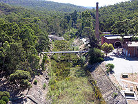
the river has historically passed hazardous industrial sites. This includes the Midland Railway Workshops
Midland Railway Workshops
The Midland Railway Workshops in Midland, Western Australia were the main workshops for the Western Australian Government Railways for over 80 years.-History:...
site and the Midland livestock sale yards.
Dams
It is dammed in two places - the best known is the upper river dam known as Mundaring Weir which was part of C.Y O'Connor's Goldfields Water Supply SchemeGoldfields Water Supply Scheme
The Goldfields Water Supply Scheme is a pipeline and dam project which delivers potable water to communities in Western Australia's Eastern Goldfields, particularly Coolgardie and Kalgoorlie...
.
Since the lower dam - known as the Pipehead Dam has been constructed in the 1970s, flooding of the lower Helena River (in East Guildford and Guildford
Guildford, Western Australia
Guildford is a suburb of Perth, Western Australia, located 13 km northeast of the city. Its Local Government Area is the City of Swan.-History:Guildford was established in 1829 on the Swan River, being sited near a permanent fresh water supply...
) has been substantially reduced. Most of the water collected in the Pipehead Dam is pumped back into Mundaring Weir. Due to this, restrictions in the Helena River catchment have been made to not allow activities that affect the quality of the Pipehad Dam - despite being adjacent to the built up areas within the Shire of Mundaring
Shire of Mundaring
The Shire of Mundaring is a Local Government Area on the eastern fringe of metropolitan Perth, the capital of Western Australia. The Shire covers an area of and has a population of 35,097 .-History:...
on the north side of the Helena River catchment.
Bridges
The bridges design and strength were of releavnt to higher water flow prior to the construction of the pipehead dam, as significant flooding occurred in the early and mid twentieth century.The main bridges are at: -
- Below Mundaring Weir
- Helena Valley Locality
- Bellevue - Reid Highway
- Midland -
- Woodbridge -
- East Guildford -
- Guildford -