

Sulphur Creek (California)
Encyclopedia
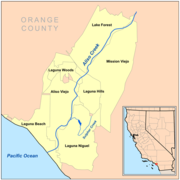
Sulphur Creek is a 4.5 miles (7.2 km) tributary of Aliso Creek in Orange County
in the U.S. state
of California
. Draining about 6 square miles (15.5 km²) of mostly residential land in the southern San Joaquin Hills
, it is the creek's largest tributary.
Geologically the Sulphur Creek watershed was once part of a large and shallow sea that covered most of southern California. As the San Joaquin Hills rose and river sediments were deposited, land gradually emerged to form the present-day Orange County coast. Sulphur Creek is located in a crumpled, hilly area in the southern part of this range, formed differently from the continuous mountain chain to the north. Historically, being south of Aliso Creek, the Sulphur Creek watershed was part of the territory of the semi-nomad
ic Acjachemen Indian group, conquered by Spanish conquistador
s in the 17th and 18th centuries and renamed the Juaneño
by them.
During the 19th century, the watershed became part of a rancho
. In 1966, the creek was dammed to form Sulphur Creek Reservoir
, while the surrounding hills were leveled as residential communities were constructed in the area following the '60s and '70s. The creek's basin eventually became part of the cities of Laguna Hills
, Laguna Niguel
, and a small portion in San Juan Capistrano. Increasing urban runoff
in the 1960s caused most of the flow in the creek to be unnatural. The creek has since been channelized along most of its length to prevent floods from inundating the roads and houses that now line much of its banks.
The Sulphur Creek watershed includes parts of Laguna Niguel Regional Park
and Aliso and Wood Canyons Regional Park. Despite its heavy pollution and increasing population of exotic species, for much of its length the creek is a riparian corridor.
exiting into daylight downstream of a shopping center near the intersection of Crown Valley Parkway and Greenfield Drive. It then flows generally south through a concrete storm channel, then diverted into another culvert that takes it underneath a small access road. For the next few miles, the creek parallels Crown Valley Parkway as it winds west and south through a valley almost entirely filled by residential development. The creek flows through a concrete channel and three more culverts before regaining its natural riverbed. At the third of these four culverts, the creek enters Sulphur Creek Park, which follows the Sulphur Creek riparian corridor to where it turns west-northwest into Crown Valley Park, just upstream of Laguna Niguel Regional Park
. Here, it receives two small tributaries (Niguel Storm Drain and an unnamed creek flowing from a spring on the hillside) on the left bank. The creek then enters a box-cut concrete channel that takes it to Sulphur Creek Reservoir
, a 44 acre (0.17806184 km²) lake about 1.5 miles (2.4 km) long, formed by a dam at its north end. At the lake, another small unnamed tributary, from a filled-in canyon on the east side, joins Sulphur Creek.
The creek then exits the dam from the concrete spillway
on the east side, flowing into a small valley inside Laguna Niguel Regional Park. About 0.5 mile (0.80467 km) downstream from Sulphur Creek Reservoir, it receives the water of a large storm drain
on the right bank. This storm drain is responsible for much of the pollution problems in the Sulphur Creek watershed.
It then flows past a small mountain on the north, known as Kite Hill, and is diverted into a large culvert underneath Alicia Parkway that drains it to a small canyon. The creek then flows into Aliso Creek, just outside the boundary of Aliso and Wood Canyons Regional Park.
began along a blind thrust fault
that stretches north into the Los Angeles Basin
, eventually rising to an average of 500 to 700 ft (152.4 to 213.4 m) above sea level, with the highest peaks topping out at about 1000 feet (304.8 m). Rising at about 0.6 to 0.8 ft (0.18288 to 0.24384 m) per one thousand years, a series of marine terraces formed along with the hills' uplift.
This uplift changed the course of Sulphur Creek to run north to Aliso Creek, instead of flowing south to Salt Creek (see Watershed).
River sediments helped to create the broad and flat terrain and river valleys between the San Joaquin Hills and the much higher Santa Ana Mountains
to the east. Sulphur Creek's watershed is located in a southern area of the San Joaquin Hills where many smaller hills have formed in a wider area instead of a single, tall, narrow mountain chain. These lower hills are composed primarily of sedimentary rocks and date from the Miocene
period. The oldest rocks in this area are referred to as the Vaqueros Formation, while the younger are named the Monterey Formation
. This hilly area is drained by Sulphur Creek to the northwest, Salt Creek to the south, small and unnamed coastal canyons to the southwest, and small tributaries of Trabuco
and Oso
Creeks to the east. This area is located northwest of the San Juan Creek
valley, southeast of the Aliso Creek valley, and west of the Oso Creek
drainage.
watershed, a tributary basin of the Trabuco Creek
watershed. Most of the basin of Sulphur Creek is hilly, but not very mountainous, although the creek has been largely changed by human occupation. Several canyons that originally drained into the creek have been filled in with material excavated from the surrounding mountain-tops, creating smoother terrain. Many present-day storm drain
s still follow the original course of these canyons. About 30 percent of the creek's course has been inundated by the Sulphur Creek Reservoir
, formed in the 1950s by a large dam across a broad north-trending valley.
The Sulphur Creek watershed has had a long history of water pollution, which can be attributed to residential development. While no raw sewage flows into the creek, the creek is contaminated by large quantities of urban runoff
from impervious paved surfaces that collects toxins before pouring untreated into the creek. There are over four large storm drain outlets that pour directly into Sulphur Creek. Such untreated runoff has caused E. coli
and Enterovirus
to increasingly harm the creek and its remaining biodiversity. Channelization is also another factor, and standing water in the Sulphur Creek Reservoir
has suffered eutrophication
. The primary source of bacteria contamination is the largest tributary of Sulphur Creek, now mostly underground. The channel joins the creek not too far from its mouth. It has been proved that 87 percent of the Sulphur Creek mainstem is severely degraded.
and Trabuco
creeks.
A nearby village, Niguili, was located near the mouth of Aliso Creek likely near the confluence of Aliso and Sulphur Creeks. Present-day Laguna Niguel
takes its name from this settlement. The Acjachemen were renamed the Juaneño
by Spanish priests in the 18th century, who established a mission
at the present-day location of San Juan Capistrano. Following the Spanish arrival, most Juaneño clustered around the mission in the south. Like many other once widespread Juaneño villages, Niguili was likely abandoned soon after, and there is no trace of it remaining.
From 1842 to the 1960s, the entire land area was known as Rancho Niguel
, a Mexican land grant
originally belonging to Juan Avila. Eventually, after passing through several ownerships, the ranch was purchased in 1881 by Lewis Moulton and Jean Pierre Daguerre, who expanded it to 21000 acres (85 km²). By the 1960s, the City of Laguna Niguel bought a large portion of the ranch from the Moulton family; it was later donated to the county for recreational use. Resultantly, the upper and lower sections of the creek are now under county ownership, and the Sulphur Creek Reservoir is managed by the Orange County Flood Control District.
In the 1950s, a large dam
, about 485 feet (147.8 m) long and 42 feet (12.8 m) high, was raised across lower Sulphur Creek by the U.S. Army Corps of Engineers to create Sulphur Creek Reservoir
(otherwise known as Laguna Niguel Lake). This flooded 1.5 miles (2.4 km) and 44 acre (0.17806184 km²) of the original course of the creek, creating a 520 acre.foot impoundment. This lake was annually stocked with fish, and by the 1960s, residential communities began to rise on the hills west of the main (southward-flowing) segment of the creek, while increasingly contaminated urban runoff
began to contribute to the creek's flow. These hills originally consisted of high, narrow ridges dissected by steep but shallow and short canyons, but were leveled to make way for buildings. In 1973 the 236 acre (0.95505896 km²) Laguna Niguel Regional Park was established in the lower third of the creek course, covering the extent of the creek from the head of Sulphur Creek Reservoir to where the creek crosses Alicia Parkway through a large culvert. In 1990 the final reach of the creek became part of Aliso and Wood Canyons Regional Park.
and coastal sage scrub
, with native riparian vegetation, likely consisting of live oak
, sycamore
s, and alders (the namesake of Aliso Creek; Aliso is the Spanish translation of Alder) and other small trees, lined the small and seasonally flowing creek. Fish were likely nonexistent in the historic Sulphur Creek watershed - although Aliso Creek was perennial, steelhead trout were found to not have inhabited Aliso Creek even during flow periods, despite claims of some residents. (See Wildlife of Aliso Creek for a detailed explanation on the absence of steelhead.)
 With the introduction of non-native species, predominantly giant reed, castor bean and tobacco
tree, native plant species in the watershed began to die out. As giant reed is not suitable habitat for many species, areas infested by giant reed are biologically dead in comparison with unaffected areas. It can grow extremely fast, removing too much water from the creek, and during flood events, many parts of the giant reed can wash downstream and re-establish themselves as a new colony, increasing the problem. Along with increasing concentrations of nutrients from fertilizer and other substances contained in runoff, algal blooms began to hurt the water quality of the creek, especially above Sulphur Creek Reservoir. The historically seasonal creek was replaced with a constant flow of polluted water from several large storm drains and many smaller ones.
Fish thrived for a limited time in Sulphur Creek between the introduction of perennial flows and the devastating floods at the end of the 20th century. These floods wiped out many of the remaining riparian areas lining waterways in the watershed. Despite the massive environmental degradation in the Sulphur Creek watershed, it is not biologically dead yet, and still supports some native species. Work is under way in the watershed to remove non-native species and restore native riparian vegetation.
Aliso and Wood Canyons Regional Park, which is located at the lower extreme of Sulphur Creek, supports far more native species than the Sulphur Creek watershed (see Wildlife of Aliso Creek for detail).
, catfish
and bass
. Aside from the reservoir, there is no body of water in the watershed that is navigable. There are several other parks in the watershed; these are Crown Valley Park, Sulphur Creek Park and others. A paved trail follows Sulphur Creek from near the terminus of Crown Valley Park to near its mouth at Alicia Parkway.
 The Geographic Names Information System
lists "Arroyo Salada" (Spanish
: Salt Canyon) as a variant name. Cañada Salada, translated to "Valley of Salt" or "Salt Canyon" (Durham's Place Names of the Greater Los Angeles Area, 2001) is another name for the lower section of the creek. These names, dating to Spanish times, imply that the creek was naturally salty or briny. As Salt Creek to the south bears a name of similar meaning, and that the "Arroyo Salada" Storm Channel occupies the lower section of the prehistoric Sulphur Creek watershed, there is further proof by salt concentrations that the two watersheds were once linked (see Watershed).
Orange County, California
Orange County is a county in the U.S. state of California. Its county seat is Santa Ana. As of the 2010 census, its population was 3,010,232, up from 2,846,293 at the 2000 census, making it the third most populous county in California, behind Los Angeles County and San Diego County...
in the U.S. state
U.S. state
A U.S. state is any one of the 50 federated states of the United States of America that share sovereignty with the federal government. Because of this shared sovereignty, an American is a citizen both of the federal entity and of his or her state of domicile. Four states use the official title of...
of California
California
California is a state located on the West Coast of the United States. It is by far the most populous U.S. state, and the third-largest by land area...
. Draining about 6 square miles (15.5 km²) of mostly residential land in the southern San Joaquin Hills
San Joaquin Hills
The San Joaquin Hills are a set of low hills in coastal Orange County, California. They extend in a northwest-southeast direction, starting in the northwest in Newport Beach at the southern edge of the Los Angeles Basin, and extending southeast to San Juan Capistrano.-Geography and habitats:Named...
, it is the creek's largest tributary.
Geologically the Sulphur Creek watershed was once part of a large and shallow sea that covered most of southern California. As the San Joaquin Hills rose and river sediments were deposited, land gradually emerged to form the present-day Orange County coast. Sulphur Creek is located in a crumpled, hilly area in the southern part of this range, formed differently from the continuous mountain chain to the north. Historically, being south of Aliso Creek, the Sulphur Creek watershed was part of the territory of the semi-nomad
Nomad
Nomadic people , commonly known as itinerants in modern-day contexts, are communities of people who move from one place to another, rather than settling permanently in one location. There are an estimated 30-40 million nomads in the world. Many cultures have traditionally been nomadic, but...
ic Acjachemen Indian group, conquered by Spanish conquistador
Conquistador
Conquistadors were Spanish soldiers, explorers, and adventurers who brought much of the Americas under the control of Spain in the 15th to 16th centuries, following Europe's discovery of the New World by Christopher Columbus in 1492...
s in the 17th and 18th centuries and renamed the Juaneño
Juaneño
The Juaneño or Acagchemem are a Native American group from Southern California. The Juaneño lived in what is now part of Orange and San Diego Counties and received their Spanish name from the priests of the California mission chain due to their proximity to Mission San Juan Capistrano...
by them.
During the 19th century, the watershed became part of a rancho
Ranchos of California
The Spanish, and later the Méxican government encouraged settlement of territory now known as California by the establishment of large land grants called ranchos, from which the English ranch is derived. Devoted to raising cattle and sheep, the owners of the ranchos attempted to pattern themselves...
. In 1966, the creek was dammed to form Sulphur Creek Reservoir
Sulphur Creek Reservoir
Sulphur Creek Reservoir is an artificial fishing and recreational lake in Laguna Niguel, California. It is created by the Sulphur Creek Dam, which was completed in 1966. It is located at and is above sea level. It is fed from two sources, one of which is Sulphur Creek itself and one is a storm...
, while the surrounding hills were leveled as residential communities were constructed in the area following the '60s and '70s. The creek's basin eventually became part of the cities of Laguna Hills
Laguna Hills, California
Laguna Hills is a city located in southern Orange County, California, United States. Its name refers to its proximity to Laguna Canyon and the much older Laguna Beach. Other newer cities nearby—Laguna Niguel and Laguna Woods—are similarly named.-Geography:...
, Laguna Niguel
Laguna Niguel, California
Laguna Niguel is an affluent city located in southern Orange County, California. The name "Laguna Niguel" is derived from the Spanish word "Laguna" which means lagoon, and the word "Nigueli" which was the name of a Juaneño Indian village that was once located on Aliso Creek. The population was...
, and a small portion in San Juan Capistrano. Increasing urban runoff
Urban runoff
Urban runoff is surface runoff of rainwater created by urbanization. This runoff is a major source of water pollution in many parts of the United States and other urban communities worldwide.-Overview:...
in the 1960s caused most of the flow in the creek to be unnatural. The creek has since been channelized along most of its length to prevent floods from inundating the roads and houses that now line much of its banks.
The Sulphur Creek watershed includes parts of Laguna Niguel Regional Park
Laguna Niguel Regional Park
Laguna Niguel Regional Park is a public park in Laguna Niguel, in southern Orange County, California. Its main feature is Sulphur Creek Reservoir, located within the park's boundaries.Laguna Niguel's 4th of July fireworks show is held at the park every year....
and Aliso and Wood Canyons Regional Park. Despite its heavy pollution and increasing population of exotic species, for much of its length the creek is a riparian corridor.
Course
The creek begins as a storm culvertCulvert
A culvert is a device used to channel water. It may be used to allow water to pass underneath a road, railway, or embankment. Culverts can be made of many different materials; steel, polyvinyl chloride and concrete are the most common...
exiting into daylight downstream of a shopping center near the intersection of Crown Valley Parkway and Greenfield Drive. It then flows generally south through a concrete storm channel, then diverted into another culvert that takes it underneath a small access road. For the next few miles, the creek parallels Crown Valley Parkway as it winds west and south through a valley almost entirely filled by residential development. The creek flows through a concrete channel and three more culverts before regaining its natural riverbed. At the third of these four culverts, the creek enters Sulphur Creek Park, which follows the Sulphur Creek riparian corridor to where it turns west-northwest into Crown Valley Park, just upstream of Laguna Niguel Regional Park
Laguna Niguel Regional Park
Laguna Niguel Regional Park is a public park in Laguna Niguel, in southern Orange County, California. Its main feature is Sulphur Creek Reservoir, located within the park's boundaries.Laguna Niguel's 4th of July fireworks show is held at the park every year....
. Here, it receives two small tributaries (Niguel Storm Drain and an unnamed creek flowing from a spring on the hillside) on the left bank. The creek then enters a box-cut concrete channel that takes it to Sulphur Creek Reservoir
Sulphur Creek Reservoir
Sulphur Creek Reservoir is an artificial fishing and recreational lake in Laguna Niguel, California. It is created by the Sulphur Creek Dam, which was completed in 1966. It is located at and is above sea level. It is fed from two sources, one of which is Sulphur Creek itself and one is a storm...
, a 44 acre (0.17806184 km²) lake about 1.5 miles (2.4 km) long, formed by a dam at its north end. At the lake, another small unnamed tributary, from a filled-in canyon on the east side, joins Sulphur Creek.
The creek then exits the dam from the concrete spillway
Spillway
A spillway is a structure used to provide the controlled release of flows from a dam or levee into a downstream area, typically being the river that was dammed. In the UK they may be known as overflow channels. Spillways release floods so that the water does not overtop and damage or even destroy...
on the east side, flowing into a small valley inside Laguna Niguel Regional Park. About 0.5 mile (0.80467 km) downstream from Sulphur Creek Reservoir, it receives the water of a large storm drain
Storm drain
A storm drain, storm sewer , stormwater drain or drainage well system or simply a drain or drain system is designed to drain excess rain and ground water from paved streets, parking lots, sidewalks, and roofs. Storm drains vary in design from small residential dry wells to large municipal systems...
on the right bank. This storm drain is responsible for much of the pollution problems in the Sulphur Creek watershed.
It then flows past a small mountain on the north, known as Kite Hill, and is diverted into a large culvert underneath Alicia Parkway that drains it to a small canyon. The creek then flows into Aliso Creek, just outside the boundary of Aliso and Wood Canyons Regional Park.
Geology
About ten million years ago, much of western and southern Orange County and most of coastal Southern California was part of a warm and shallow sea. This sea receded over time, leaving a large and flat coastal plain. Over 1.22 million years ago, the uplift of the San Joaquin HillsSan Joaquin Hills
The San Joaquin Hills are a set of low hills in coastal Orange County, California. They extend in a northwest-southeast direction, starting in the northwest in Newport Beach at the southern edge of the Los Angeles Basin, and extending southeast to San Juan Capistrano.-Geography and habitats:Named...
began along a blind thrust fault
Thrust fault
A thrust fault is a type of fault, or break in the Earth's crust across which there has been relative movement, in which rocks of lower stratigraphic position are pushed up and over higher strata. They are often recognized because they place older rocks above younger...
that stretches north into the Los Angeles Basin
Los Angeles Basin
The Los Angeles Basin is the coastal sediment-filled plain located between the Peninsular and Transverse ranges in southern California in the United States containing the central part of the city of Los Angeles as well as its southern and southeastern suburbs...
, eventually rising to an average of 500 to 700 ft (152.4 to 213.4 m) above sea level, with the highest peaks topping out at about 1000 feet (304.8 m). Rising at about 0.6 to 0.8 ft (0.18288 to 0.24384 m) per one thousand years, a series of marine terraces formed along with the hills' uplift.
This uplift changed the course of Sulphur Creek to run north to Aliso Creek, instead of flowing south to Salt Creek (see Watershed).
River sediments helped to create the broad and flat terrain and river valleys between the San Joaquin Hills and the much higher Santa Ana Mountains
Santa Ana Mountains
The Santa Ana Mountains are a short peninsular mountain range along the coast of Southern California in the United States. They extend for approximately 36 mi southeast of the Los Angeles Basin largely along the border between Orange and Riverside counties.- Geography :The range starts in the...
to the east. Sulphur Creek's watershed is located in a southern area of the San Joaquin Hills where many smaller hills have formed in a wider area instead of a single, tall, narrow mountain chain. These lower hills are composed primarily of sedimentary rocks and date from the Miocene
Miocene
The Miocene is a geological epoch of the Neogene Period and extends from about . The Miocene was named by Sir Charles Lyell. Its name comes from the Greek words and and means "less recent" because it has 18% fewer modern sea invertebrates than the Pliocene. The Miocene follows the Oligocene...
period. The oldest rocks in this area are referred to as the Vaqueros Formation, while the younger are named the Monterey Formation
Monterey Formation
The Monterey Formation is an extensive Miocene oil-rich geological sedimentary formation in California, with massive outcroppings of the formation in areas of the California Coast Ranges, Peninsular Ranges, and on some of California's off-shore islands...
. This hilly area is drained by Sulphur Creek to the northwest, Salt Creek to the south, small and unnamed coastal canyons to the southwest, and small tributaries of Trabuco
Trabuco Creek
Trabuco Creek is a small river in the U.S. state of California, flowing from the westernmost extreme of Riverside County through Orange County to join San Juan Creek in the city of San Juan Capistrano. long, its watershed covers in southeastern Orange County, including portions of three...
and Oso
Oso Creek
Oso Creek is an approximately tributary of Trabuco Creek in southern Orange County in the U.S. state of California. Draining about in a region north of the San Joaquin Hills and south of the Santa Ana Mountains, the creek is Trabuco Creek's largest tributary, and is part of the San Juan Creek...
Creeks to the east. This area is located northwest of the San Juan Creek
San Juan Creek
San Juan Creek, also called the San Juan River, is a stream in Orange County, California that consists of a catchment basin encompassing . Its mainstem rises in the Santa Ana Mountains, in the Trabuco Ranger District of the Cleveland National Forest...
valley, southeast of the Aliso Creek valley, and west of the Oso Creek
Oso Creek
Oso Creek is an approximately tributary of Trabuco Creek in southern Orange County in the U.S. state of California. Draining about in a region north of the San Joaquin Hills and south of the Santa Ana Mountains, the creek is Trabuco Creek's largest tributary, and is part of the San Juan Creek...
drainage.
Watershed
The Sulphur Creek subwatershed covers about 17 percent of the entire Aliso Creek watershed, encompassing about 6 square miles (15.5 km²) in the southwesternmost corner of the 35 square miles (90.6 km²) Aliso Creek basin. Primarily residential, it is bordered on the north by the Aliso Hills Channel drainage area (tributary to Aliso Creek), on the south and southwest by the basin of Salt Creek, and to the west by the Oso CreekOso Creek
Oso Creek is an approximately tributary of Trabuco Creek in southern Orange County in the U.S. state of California. Draining about in a region north of the San Joaquin Hills and south of the Santa Ana Mountains, the creek is Trabuco Creek's largest tributary, and is part of the San Juan Creek...
watershed, a tributary basin of the Trabuco Creek
Trabuco Creek
Trabuco Creek is a small river in the U.S. state of California, flowing from the westernmost extreme of Riverside County through Orange County to join San Juan Creek in the city of San Juan Capistrano. long, its watershed covers in southeastern Orange County, including portions of three...
watershed. Most of the basin of Sulphur Creek is hilly, but not very mountainous, although the creek has been largely changed by human occupation. Several canyons that originally drained into the creek have been filled in with material excavated from the surrounding mountain-tops, creating smoother terrain. Many present-day storm drain
Storm drain
A storm drain, storm sewer , stormwater drain or drainage well system or simply a drain or drain system is designed to drain excess rain and ground water from paved streets, parking lots, sidewalks, and roofs. Storm drains vary in design from small residential dry wells to large municipal systems...
s still follow the original course of these canyons. About 30 percent of the creek's course has been inundated by the Sulphur Creek Reservoir
Sulphur Creek Reservoir
Sulphur Creek Reservoir is an artificial fishing and recreational lake in Laguna Niguel, California. It is created by the Sulphur Creek Dam, which was completed in 1966. It is located at and is above sea level. It is fed from two sources, one of which is Sulphur Creek itself and one is a storm...
, formed in the 1950s by a large dam across a broad north-trending valley.
The Sulphur Creek watershed has had a long history of water pollution, which can be attributed to residential development. While no raw sewage flows into the creek, the creek is contaminated by large quantities of urban runoff
Urban runoff
Urban runoff is surface runoff of rainwater created by urbanization. This runoff is a major source of water pollution in many parts of the United States and other urban communities worldwide.-Overview:...
from impervious paved surfaces that collects toxins before pouring untreated into the creek. There are over four large storm drain outlets that pour directly into Sulphur Creek. Such untreated runoff has caused E. coli
Escherichia coli
Escherichia coli is a Gram-negative, rod-shaped bacterium that is commonly found in the lower intestine of warm-blooded organisms . Most E. coli strains are harmless, but some serotypes can cause serious food poisoning in humans, and are occasionally responsible for product recalls...
and Enterovirus
Enterovirus
Enteroviruses are a genus of ssRNA viruses associated with several human and mammalian diseases. Serologic studies have distinguished 66 human enterovirus serotypes on the basis of antibody neutralization tests. Additional antigenic variants have been defined within several of the serotypes on the...
to increasingly harm the creek and its remaining biodiversity. Channelization is also another factor, and standing water in the Sulphur Creek Reservoir
Sulphur Creek Reservoir
Sulphur Creek Reservoir is an artificial fishing and recreational lake in Laguna Niguel, California. It is created by the Sulphur Creek Dam, which was completed in 1966. It is located at and is above sea level. It is fed from two sources, one of which is Sulphur Creek itself and one is a storm...
has suffered eutrophication
Eutrophication
Eutrophication or more precisely hypertrophication, is the movement of a body of water′s trophic status in the direction of increasing plant biomass, by the addition of artificial or natural substances, such as nitrates and phosphates, through fertilizers or sewage, to an aquatic system...
. The primary source of bacteria contamination is the largest tributary of Sulphur Creek, now mostly underground. The channel joins the creek not too far from its mouth. It has been proved that 87 percent of the Sulphur Creek mainstem is severely degraded.
History
Located to the southwest of Aliso Creek, Sulphur Creek historically lay in the territory of the Acjachemen Indian group, whose main population center was actually farther south, at the confluence of San JuanSan Juan Creek
San Juan Creek, also called the San Juan River, is a stream in Orange County, California that consists of a catchment basin encompassing . Its mainstem rises in the Santa Ana Mountains, in the Trabuco Ranger District of the Cleveland National Forest...
and Trabuco
Trabuco Creek
Trabuco Creek is a small river in the U.S. state of California, flowing from the westernmost extreme of Riverside County through Orange County to join San Juan Creek in the city of San Juan Capistrano. long, its watershed covers in southeastern Orange County, including portions of three...
creeks.
A nearby village, Niguili, was located near the mouth of Aliso Creek likely near the confluence of Aliso and Sulphur Creeks. Present-day Laguna Niguel
Laguna Niguel, California
Laguna Niguel is an affluent city located in southern Orange County, California. The name "Laguna Niguel" is derived from the Spanish word "Laguna" which means lagoon, and the word "Nigueli" which was the name of a Juaneño Indian village that was once located on Aliso Creek. The population was...
takes its name from this settlement. The Acjachemen were renamed the Juaneño
Juaneño
The Juaneño or Acagchemem are a Native American group from Southern California. The Juaneño lived in what is now part of Orange and San Diego Counties and received their Spanish name from the priests of the California mission chain due to their proximity to Mission San Juan Capistrano...
by Spanish priests in the 18th century, who established a mission
Mission San Juan Capistrano
Mission San Juan Capistrano was a Spanish mission in Southern California, located in present-day San Juan Capistrano. It was founded on All Saints Day November 1, 1776, by Spanish Catholics of the Franciscan Order...
at the present-day location of San Juan Capistrano. Following the Spanish arrival, most Juaneño clustered around the mission in the south. Like many other once widespread Juaneño villages, Niguili was likely abandoned soon after, and there is no trace of it remaining.
From 1842 to the 1960s, the entire land area was known as Rancho Niguel
Rancho Niguel
Rancho Niguel was a Mexican land grant in present day Orange County, California given in 1842 by Governor Juan B. Alvarado to Juan Avila. The rancho was named for a local Indian village called "Niguili." The grant extended along the Pacific coast from Laguna Canyon and Laguna Beach, past Aliso...
, a Mexican land grant
Ranchos of California
The Spanish, and later the Méxican government encouraged settlement of territory now known as California by the establishment of large land grants called ranchos, from which the English ranch is derived. Devoted to raising cattle and sheep, the owners of the ranchos attempted to pattern themselves...
originally belonging to Juan Avila. Eventually, after passing through several ownerships, the ranch was purchased in 1881 by Lewis Moulton and Jean Pierre Daguerre, who expanded it to 21000 acres (85 km²). By the 1960s, the City of Laguna Niguel bought a large portion of the ranch from the Moulton family; it was later donated to the county for recreational use. Resultantly, the upper and lower sections of the creek are now under county ownership, and the Sulphur Creek Reservoir is managed by the Orange County Flood Control District.
In the 1950s, a large dam
Sulphur Creek Dam
Sulphur Creek Dam is a dam across Sulphur Creek in Orange County, in the U.S. state of California. The dam and the Sulphur Creek Reservoir lie entirely within the city of Laguna Niguel...
, about 485 feet (147.8 m) long and 42 feet (12.8 m) high, was raised across lower Sulphur Creek by the U.S. Army Corps of Engineers to create Sulphur Creek Reservoir
Sulphur Creek Reservoir
Sulphur Creek Reservoir is an artificial fishing and recreational lake in Laguna Niguel, California. It is created by the Sulphur Creek Dam, which was completed in 1966. It is located at and is above sea level. It is fed from two sources, one of which is Sulphur Creek itself and one is a storm...
(otherwise known as Laguna Niguel Lake). This flooded 1.5 miles (2.4 km) and 44 acre (0.17806184 km²) of the original course of the creek, creating a 520 acre.foot impoundment. This lake was annually stocked with fish, and by the 1960s, residential communities began to rise on the hills west of the main (southward-flowing) segment of the creek, while increasingly contaminated urban runoff
Urban runoff
Urban runoff is surface runoff of rainwater created by urbanization. This runoff is a major source of water pollution in many parts of the United States and other urban communities worldwide.-Overview:...
began to contribute to the creek's flow. These hills originally consisted of high, narrow ridges dissected by steep but shallow and short canyons, but were leveled to make way for buildings. In 1973 the 236 acre (0.95505896 km²) Laguna Niguel Regional Park was established in the lower third of the creek course, covering the extent of the creek from the head of Sulphur Creek Reservoir to where the creek crosses Alicia Parkway through a large culvert. In 1990 the final reach of the creek became part of Aliso and Wood Canyons Regional Park.
Wildlife and flora
Historically, the Sulphur Creek watershed was mostly hilly terrain consisting of chaparralChaparral
Chaparral is a shrubland or heathland plant community found primarily in the U.S. state of California and in the northern portion of the Baja California peninsula, Mexico...
and coastal sage scrub
Coastal sage scrub
Coastal sage scrub is a low scrubland plant community found in the California chaparral and woodlands ecoregion of coastal California and northern Baja California. It is characterized by low-growing aromatic, and drought-deciduous shrubs adapted to the semi-arid Mediterranean climate of the...
, with native riparian vegetation, likely consisting of live oak
Live oak
Live oak , also known as the southern live oak, is a normally evergreen oak tree native to the southeastern United States...
, sycamore
Sycamore
Sycamore is a name which is applied at various times and places to three very different types of trees, but with somewhat similar leaf forms....
s, and alders (the namesake of Aliso Creek; Aliso is the Spanish translation of Alder) and other small trees, lined the small and seasonally flowing creek. Fish were likely nonexistent in the historic Sulphur Creek watershed - although Aliso Creek was perennial, steelhead trout were found to not have inhabited Aliso Creek even during flow periods, despite claims of some residents. (See Wildlife of Aliso Creek for a detailed explanation on the absence of steelhead.)
Tobacco
Tobacco is an agricultural product processed from the leaves of plants in the genus Nicotiana. It can be consumed, used as a pesticide and, in the form of nicotine tartrate, used in some medicines...
tree, native plant species in the watershed began to die out. As giant reed is not suitable habitat for many species, areas infested by giant reed are biologically dead in comparison with unaffected areas. It can grow extremely fast, removing too much water from the creek, and during flood events, many parts of the giant reed can wash downstream and re-establish themselves as a new colony, increasing the problem. Along with increasing concentrations of nutrients from fertilizer and other substances contained in runoff, algal blooms began to hurt the water quality of the creek, especially above Sulphur Creek Reservoir. The historically seasonal creek was replaced with a constant flow of polluted water from several large storm drains and many smaller ones.
Fish thrived for a limited time in Sulphur Creek between the introduction of perennial flows and the devastating floods at the end of the 20th century. These floods wiped out many of the remaining riparian areas lining waterways in the watershed. Despite the massive environmental degradation in the Sulphur Creek watershed, it is not biologically dead yet, and still supports some native species. Work is under way in the watershed to remove non-native species and restore native riparian vegetation.
Aliso and Wood Canyons Regional Park, which is located at the lower extreme of Sulphur Creek, supports far more native species than the Sulphur Creek watershed (see Wildlife of Aliso Creek for detail).
Recreation
Sulphur Creek Reservoir is the primary recreational facility in the watershed, and is said to be one of the largest fisheries of Southern Orange County. The lake is annually stocked with bluegillBluegill
The Bluegill is a species of freshwater fish sometimes referred to as bream, brim, or copper nose. It is a member of the sunfish family Centrarchidae of the order Perciformes.-Range and distribution:...
, catfish
Catfish
Catfishes are a diverse group of ray-finned fish. Named for their prominent barbels, which resemble a cat's whiskers, catfish range in size and behavior from the heaviest and longest, the Mekong giant catfish from Southeast Asia and the second longest, the wels catfish of Eurasia, to detritivores...
and bass
Bass (fish)
Bass is a name shared by many different species of popular gamefish. The term encompasses both freshwater and marine species. All belong to the large order Perciformes, or perch-like fishes, and in fact the word bass comes from Middle English bars, meaning "perch."-Types of basses:*The temperate...
. Aside from the reservoir, there is no body of water in the watershed that is navigable. There are several other parks in the watershed; these are Crown Valley Park, Sulphur Creek Park and others. A paved trail follows Sulphur Creek from near the terminus of Crown Valley Park to near its mouth at Alicia Parkway.
Etymology
Geographic Names Information System
The Geographic Names Information System is a database that contains name and locative information about more than two million physical and cultural features located throughout the United States of America and its territories. It is a type of gazetteer...
lists "Arroyo Salada" (Spanish
Spanish language
Spanish , also known as Castilian , is a Romance language in the Ibero-Romance group that evolved from several languages and dialects in central-northern Iberia around the 9th century and gradually spread with the expansion of the Kingdom of Castile into central and southern Iberia during the...
: Salt Canyon) as a variant name. Cañada Salada, translated to "Valley of Salt" or "Salt Canyon" (Durham's Place Names of the Greater Los Angeles Area, 2001) is another name for the lower section of the creek. These names, dating to Spanish times, imply that the creek was naturally salty or briny. As Salt Creek to the south bears a name of similar meaning, and that the "Arroyo Salada" Storm Channel occupies the lower section of the prehistoric Sulphur Creek watershed, there is further proof by salt concentrations that the two watersheds were once linked (see Watershed).
See also
- Tributaries of Aliso Creek
- Wood Canyon CreekWood Canyon CreekWood Canyon Creek is a small stream in Aliso and Wood Canyons Regional Park, which is located in Orange County in the U.S. state of California. A tributary of Aliso Creek, it drains a notable valley bounded on the east side by Aliso Viejo....
- Wood Canyon Creek
- List of rivers of Orange County, California
- List of rivers of California
Works cited
- Armor, Samuel (1921). History of Orange County, California. Historic Record Co.
- Carle, David (2005). Introduction to Water in California. University of California Press. ISBN 0-520-24086-3.
- Corby, Grant White (1922). The geology and paleontology of the San Joaquin and Niguel Hills, Orange County, California. Stanford University.
- Durham, David L. (2001). Durham's Place Names of Greater Los Angeles. Quill Driver Books. ISBN 1-88499-528-4.
- Fritsche, A. Eugene; Behl, Richard J (2008). Geology of Orange County, California and the Irvine Ranch National Natural Landmark. Pacific Section, SEPM - The Society for Sedimentary Geology. ISBN 1-878861-99-9.